2013 CT Anglers Guide - CT.gov
2013 CT Anglers Guide - CT.gov
2013 CT Anglers Guide - CT.gov
Create successful ePaper yourself
Turn your PDF publications into a flip-book with our unique Google optimized e-Paper software.
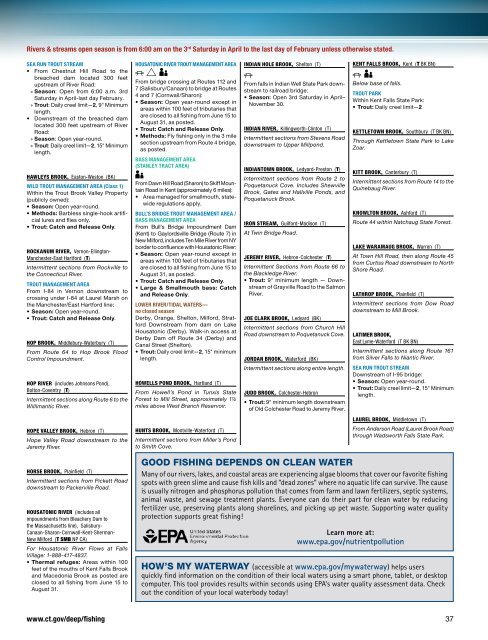
Rivers & streams open season is from 6:00 am on the 3 rd Saturday in April to the last day of February unless otherwise stated.<br />
SEA RUN TROUT STREAM<br />
• From Chestnut Hill Road to the<br />
breached dam located 300 feet<br />
upstream of River Road:<br />
»»<br />
Season: Open from 6:00 a.m. 3rd<br />
Saturday in April-last day February.<br />
»»<br />
Trout: Daily creel limit—2, 9" Minimum<br />
length.<br />
• Downstream of the breached dam<br />
located 300 feet upstream of River<br />
Road:<br />
»»<br />
Season: Open year-round.<br />
»»<br />
Trout: Daily creel limit—2, 15" Minimum<br />
length.<br />
Hawleys Brook, Easton-Weston (BK)<br />
WILD TROUT MANAGEMENT AREA (Class 1)<br />
Within the Trout Brook Valley Property<br />
(publicly owned):<br />
• Season: Open year-round.<br />
• Methods: Barbless single-hook artificial<br />
lures and flies only.<br />
• Trout: Catch and Release Only.<br />
HOCKANUM RIVER, Vernon-Ellington-<br />
Manchester-East Hartford (T)<br />
Intermittent sections from Rockville to<br />
the Connecticut River.<br />
TROUT MANAGEMENT AREA<br />
From I-84 in Vernon downstream to<br />
crossing under I-84 at Laurel Marsh on<br />
the Manchester/East Hartford line:<br />
• Season: Open year-round.<br />
• Trout: Catch and Release Only.<br />
HOP BROOK, Middlebury-Waterbury (T)<br />
From Route 64 to Hop Brook Flood<br />
Control Impoundment.<br />
HOP RIVER (includes Johnsons Pond),<br />
Bolton-Coventry (T)<br />
Intermittent sections along Route 6 to the<br />
Willimantic River.<br />
HOUSATONIC RIVER TROUT MANAGEMENT AREA<br />
PGC<br />
From bridge crossing at Routes 112 and<br />
7 (Salisbury/Canaan) to bridge at Routes<br />
4 and 7 (Cornwall/Sharon):<br />
• Season: Open year-round except in<br />
areas within 100 feet of tributaries that<br />
are closed to all fishing from June 15 to<br />
August 31, as posted.<br />
• Trout: Catch and Release Only.<br />
• Methods: Fly fishing only in the 3 mile<br />
section upstream from Route 4 bridge,<br />
as posted.<br />
BASS MANAGEMENT AREA<br />
(Stanley Tract Area)<br />
C<br />
From Dawn Hill Road (Sharon) to Skiff Mountain<br />
Road in Kent (approximately 6 miles):<br />
• Area managed for smallmouth, statewide<br />
regulations apply.<br />
BULL’S BRIDGE TROUT MANAGEMENT AREA /<br />
BASS MANAGEMENT AREA<br />
From Bull’s Bridge Impoundment Dam<br />
(Kent) to Gaylordsville Bridge (Route 7) in<br />
New Milford, includes Ten Mile River from NY<br />
border to confluence with Housatonic River:<br />
• Season: Open year-round except in<br />
areas within 100 feet of tributaries that<br />
are closed to all fishing from June 15 to<br />
August 31, as posted.<br />
• Trout: Catch and Release Only.<br />
• Large & Smallmouth bass: Catch<br />
and Release Only.<br />
Lower river/tidal waters—<br />
no closed season<br />
Derby, Orange, Shelton, Milford, Stratford<br />
Downstream from dam on Lake<br />
Housatonic (Derby). Walk-in access at<br />
Derby Dam off Route 34 (Derby) and<br />
Canal Street (Shelton).<br />
• Trout: Daily creel limit—2, 15" minimum<br />
length.<br />
HOWELLS POND BROOK, Hartland (T)<br />
From Howell’s Pond in Tunxis State<br />
Forest to Mill Street, approximately 1½<br />
miles above West Branch Reservoir.<br />
INDIAN HOLE BROOK, Shelton (T)<br />
P<br />
From falls in Indian Well State Park downstream<br />
to railroad bridge:<br />
• Season: Open 3rd Saturday in April–<br />
November 30.<br />
INDIAN RIVER, Killingworth-Clinton (T)<br />
Intermittent sections from Stevens Road<br />
downstream to Upper Millpond.<br />
INDIANTOWN BROOK, Ledyard-Preston (T)<br />
Intermittent sections from Route 2 to<br />
Poquetanuck Cove. Includes Shewville<br />
Brook, Gates and Hallville Ponds, and<br />
Poquetanuck Brook.<br />
IRON STREAM, Guilford-Madison (T)<br />
At Twin Bridge Road.<br />
JEREMY RIVER, Hebron-Colchester (T)<br />
Intermittent Sections from Route 66 to<br />
the Blackledge River.<br />
• Trout: 9" minimum length — Downstream<br />
of Grayville Road to the Salmon<br />
River.<br />
JOE CLARK BROOK, Ledyard (BK)<br />
Intermittent sections from Church Hill<br />
Road downstream to Poquetanuck Cove.<br />
JORDAN BROOK, Waterford (BK)<br />
Intermittent sections along entire length.<br />
JUDD BROOK, Colchester-Hebron<br />
• Trout: 9" minimum length downstream<br />
of Old Colchester Road to Jeremy River.<br />
KENT FALLS BROOK, Kent (T BK BN)<br />
P C<br />
Below base of falls.<br />
TROUT PARK<br />
Within Kent Falls State Park:<br />
• Trout: Daily creel limit—2<br />
KETTLETOWN BROOK, Southbury (T BK BN)<br />
Through Kettletown State Park to Lake<br />
Zoar.<br />
KITT BROOK, Canterbury (T)<br />
Intermittent sections from Route 14 to the<br />
Quinebaug River.<br />
KNOWLTON BROOK, Ashford (T)<br />
Route 44 within Natchaug State Forest.<br />
LAKE WARAMAUG BROOK, Warren (T)<br />
At Town Hill Road, then along Route 45<br />
from Curtiss Road downstream to North<br />
Shore Road.<br />
LATHROP BROOK, Plainfield (T)<br />
Intermittent sections from Dow Road<br />
downstream to Mill Brook.<br />
LATIMER BROOK,<br />
East Lyme-Waterford (T BK BN)<br />
Intermittent sections along Route 161<br />
from Silver Falls to Niantic River.<br />
SEA RUN TROUT STREAM<br />
Downstream of I-95 bridge:<br />
• Season: Open year-round.<br />
• Trout: Daily creel limit—2, 15" Minimum<br />
length.<br />
LAUREL BROOK, Middletown (T)<br />
From Anderson Road (Laurel Brook Road)<br />
through Wadsworth Falls State Park.<br />
HOPE VALLEY BROOK, Hebron (T)<br />
Hope Valley Road downstream to the<br />
Jeremy River.<br />
HUNTS BROOK, Montville-Waterford (T)<br />
Intermittent sections from Miller’s Pond<br />
to Smith Cove.<br />
HORSE BROOK, Plainfield (T)<br />
Intermittent sections from Pickett Road<br />
downstream to Packerville Road.<br />
HOUSATONIC RIVER (includes all<br />
impoundments from Bleachery Dam to<br />
the Massachusetts line), Salisbury-<br />
Canaan-Sharon-Cornwall-Kent-Sherman-<br />
New Milford (T SMB NP CA)<br />
For Housatonic River Flows at Falls<br />
Village: 1-888-417-4837.<br />
• Thermal refuges: Areas within 100<br />
feet of the mouths of Kent Falls Brook<br />
and Macedonia Brook as posted are<br />
closed to all fishing from June 15 to<br />
August 31.<br />
Good Fishing Depends on Clean Water<br />
Many of our rivers, lakes, and coastal areas are experiencing algae blooms that cover our favorite fishing<br />
spots with green slime and cause fish kills and “dead zones” where no aquatic life can survive. The cause<br />
is usually nitrogen and phosphorus pollution that comes from farm and lawn fertilizers, septic systems,<br />
animal waste, and sewage treatment plants. Everyone can do their part for clean water by reducing<br />
fertilizer use, preserving plants along shorelines, and picking up pet waste. Supporting water quality<br />
protection supports great fishing!<br />
Learn more at:<br />
www.epa.<strong>gov</strong>/nutrientpollution<br />
How’s my waterway (accessible at www.epa.<strong>gov</strong>/mywaterway) helps users<br />
quickly find information on the condition of their local waters using a smart phone, tablet, or desktop<br />
computer. This tool provides results within seconds using EPA’s water quality assessment data. Check<br />
out the condition of your local waterbody today!<br />
www.ct.<strong>gov</strong>/deep/fishing 37


