NM 532 Curve Correction Project - New Mexico Department of ...
NM 532 Curve Correction Project - New Mexico Department of ...
NM 532 Curve Correction Project - New Mexico Department of ...

Create successful ePaper yourself
Turn your PDF publications into a flip-book with our unique Google optimized e-Paper software.
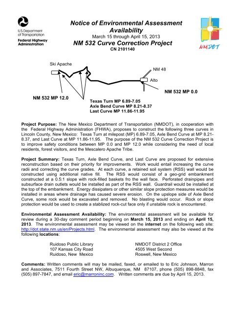
Notice <strong>of</strong> Environmental Assessment<br />
Availability<br />
March 15 through April 15, 2013<br />
<strong>NM</strong> <strong>532</strong> <strong>Curve</strong> <strong>Correction</strong> <strong>Project</strong><br />
CN 2101140<br />
Ski Apache<br />
<strong>NM</strong> 48<br />
<strong>NM</strong> <strong>532</strong> MP 12.0<br />
Texas Turn MP 6.89-7.05<br />
Axle Bend <strong>Curve</strong> MP 8.21-8.37<br />
Last <strong>Curve</strong> MP 11.86-11.95<br />
Alto<br />
<strong>NM</strong> <strong>532</strong> MP 0.0<br />
<strong>Project</strong> Purpose: The <strong>New</strong> <strong>Mexico</strong> <strong>Department</strong> <strong>of</strong> Transportation (<strong>NM</strong>DOT), in cooperation with<br />
the Federal Highway Administration (FHWA), proposes to construct the following three curves in<br />
Lincoln County, <strong>New</strong> <strong>Mexico</strong>: Texas Turn at milepost (MP) 6.89-7.05, Axle Bend <strong>Curve</strong> at MP 8.21-<br />
8.37, and Last <strong>Curve</strong> at MP 11.86-11.95. The purpose <strong>of</strong> the <strong>NM</strong> <strong>532</strong> <strong>Curve</strong> <strong>Correction</strong> <strong>Project</strong> is<br />
to improve safety conditions between MP 0.0 and MP 12.0 while considering the need <strong>of</strong> local<br />
residents, forest visitors, and the Mescalero Apache Tribe.<br />
<strong>Project</strong> Summary: Texas Turn, Axle Bend <strong>Curve</strong>, and Last <strong>Curve</strong> are proposed for extensive<br />
reconstruction based on their priority for improvements. Work would entail increasing the curve<br />
radii and correcting the curve grades. At each curve, a retained soil system (RSS) wall would be<br />
constructed using additional native fill. The RSS would consist <strong>of</strong> a geo-grid embankment<br />
constructed at a 0.5:1 slope with rock-filled baskets fro the wall face. Perforated drainpipes and<br />
subsurface drain outlets would be installed as part <strong>of</strong> the RSS wall. Guardrail would be installed at<br />
the top <strong>of</strong> the embankment. Energy dissipaters or other similar slope protection measures would be<br />
installed in areas where drainage has caused severe erosion. On the upslope side <strong>of</strong> Axle Bend<br />
<strong>Curve</strong>, some rock would be excavated and removed. No blasting would occur. Rock or slope<br />
protection would be used to create a stablized rock-cut face only if unstable rock is encountered.<br />
Environmental Assessment Availability: The environmental assessment will be available for<br />
review during a 30-day comment period beginning on March 15, 2013 and ending on April 15,<br />
2013. The environmental assessment may be viewed on the internet on the following web site:<br />
http://dot.state.nm.us/en/<strong>Project</strong>s.html. The environmental assessment may also be viewed at the<br />
following locations:<br />
Ruidoso Public Library<br />
<strong>NM</strong>DOT District 2 Office<br />
107 Kansas City Road 4505 West Second<br />
Ruidoso, <strong>New</strong> <strong>Mexico</strong><br />
Roswell, <strong>New</strong> <strong>Mexico</strong><br />
Comments: Written comments will may be mailed, faxed, or emailed to to Eric Johnson, Marron<br />
and Associates, 7511 Fourth Street NW, Albuquerque, <strong>NM</strong> 87107, phone (505) 898-8848, fax<br />
(505) 897-7847, and email eric@marroninc.com. Written comments are due by April 15, 2013.
<strong>NM</strong> <strong>532</strong> <strong>Curve</strong> <strong>Correction</strong> <strong>Project</strong><br />
MP 0.0 - MP 12.0<br />
CN 2101140<br />
Lincoln County, <strong>New</strong> <strong>Mexico</strong><br />
Environmental Assessment<br />
<strong>New</strong> <strong>Mexico</strong> <strong>Department</strong> <strong>of</strong> Transportation<br />
Federal Highway Administration<br />
March 2013
TABLE OF CONTENTS<br />
1.0 SUMMARY ................................................................................................................................1<br />
2.0 PURPOSE AND NEED, HISTORY, AND EXISTING CONDITIONS ....................................4<br />
2.1 <strong>Project</strong> Purpose and Need ......................................................................................................4<br />
2.2 <strong>Project</strong> History .......................................................................................................................4<br />
2.3 Traffic Conditions ..................................................................................................................4<br />
2.4 Roadway Conditions ..............................................................................................................6<br />
2.5 Drainage ................................................................................................................................6<br />
2.6 Right-<strong>of</strong>-way ..........................................................................................................................6<br />
3.0 ALTERNATIVES CONSIDERED ................................................................................................7<br />
3.1 Alternatives Considered but Eliminated from Further Consideration ...................................7<br />
3.2 No-Build Alternative .............................................................................................................7<br />
3.3 Recommended Build Alternative ..........................................................................................7<br />
4.0 AFFECTED ENVIRO<strong>NM</strong>ENT AND IMPACTS ..........................................................................9<br />
4.1 General <strong>Project</strong> Setting ..........................................................................................................9<br />
4.2 Landforms and Geology ........................................................................................................9<br />
4.3 Soils ................................................................................................................................9<br />
4.4 Surface and Ground Water ..................................................................................................10<br />
4.5 Wetlands ..............................................................................................................................10<br />
4.6 Vegetation ............................................................................................................................11<br />
4.7 Fish and Wildlife .................................................................................................................11<br />
4.8 Threatened and Endangered Species ...................................................................................11<br />
4.9 Cultural Resources ...............................................................................................................13<br />
4.10 Climate and Air Quality .......................................................................................................13<br />
4.11 Noise ..............................................................................................................................13<br />
4.12 Visual Resources .................................................................................................................14<br />
4.13 Communities and Land Use .................................................................................................14<br />
4.14 Socioeconomics and Environmental Justice ........................................................................14<br />
4.15 Section 4(f) Properties .........................................................................................................15<br />
4.16 Wilderness and Protected Areas ..........................................................................................16<br />
4.17 Farmland ..............................................................................................................................16<br />
4.18 Right-<strong>of</strong>-way ........................................................................................................................16<br />
4.19 Multi-Modal Transportation ................................................................................................16<br />
4.20 Recreation ............................................................................................................................16<br />
4.21 Hazardous Substances .........................................................................................................17<br />
4.22 Cumulative Impacts .............................................................................................................17<br />
4.23 Indirect Impacts ...................................................................................................................17<br />
4.24 Conclusions ..........................................................................................................................17<br />
5.0 PUBLIC INVOLVEMENT ............................................................................................................18<br />
5.1 Public Involvement and Local Coordination .......................................................................18<br />
5.2 Agency Coordination ...........................................................................................................18<br />
6.0 ENVIRO<strong>NM</strong>ENTAL COMMITMENTS ......................................................................................19<br />
i<br />
March 2013 CN 2101140
APPENDICES<br />
A <strong>Project</strong> Plans<br />
B Agency Correspondence<br />
C Bibliography<br />
FIGURES<br />
1.1 <strong>Project</strong> Area Map .................................................................................................................2<br />
1.1 <strong>Curve</strong> Location Map ............................................................................................................3<br />
2.1 Fire Perimeter Map ..............................................................................................................5<br />
3.1 Photograph <strong>of</strong> Texas Turn ...................................................................................................8<br />
3.2 Photograph <strong>of</strong> Axle Bend <strong>Curve</strong> ..........................................................................................8<br />
3.3 Photograph <strong>of</strong> Last <strong>Curve</strong> ....................................................................................................9<br />
4.1 Ground photograph <strong>of</strong> area affected by 2012 Little Bear Fire along <strong>NM</strong> <strong>532</strong> ..................12<br />
4.2 Aerial photograph <strong>of</strong> area affected by 2012 Little Bear Fire along <strong>NM</strong> <strong>532</strong> ....................12<br />
TABLES<br />
2.1 2001-2005 Crash Numbers and Locations ...........................................................................6<br />
4.1 Socioeconomic Characteristics <strong>NM</strong> <strong>532</strong> Region ...............................................................15<br />
5.1 <strong>NM</strong> <strong>532</strong> Public Involvement Meetings ..............................................................................18<br />
6.1 Environmental Commitments ............................................................................................19<br />
ii<br />
March 2013 CN 2101140
<strong>NM</strong> <strong>532</strong> <strong>Curve</strong> <strong>Correction</strong> <strong>Project</strong> Environmental Assessment<br />
1.0 SUMMARY<br />
The <strong>New</strong> <strong>Mexico</strong> <strong>Department</strong> <strong>of</strong> Transportation (<strong>NM</strong>DOT), in cooperation with the Federal Highway<br />
Administration (FHWA), proposes to reconstruct three curves <strong>of</strong> the <strong>NM</strong> <strong>532</strong> roadway in Lincoln County,<br />
<strong>New</strong> <strong>Mexico</strong> (see Figure 1.1). <strong>NM</strong> <strong>532</strong> is a rural arterial roadway that extends from <strong>NM</strong> 48 in Alto to<br />
Ski Apache, and it provides the only roadway access to Ski Apache and nearby areas on the Lincoln<br />
National Forest. The project area is located within <strong>NM</strong>DOT District 2. The <strong>NM</strong> <strong>532</strong> <strong>Curve</strong> <strong>Correction</strong><br />
<strong>Project</strong> is listed in the Fiscal Year (FY) 2012-2015 Statewide Transportation Improvement Program<br />
(STIP) Amendment 4 as control number (CN) 2101140. The <strong>NM</strong> <strong>532</strong> <strong>Curve</strong> <strong>Correction</strong> <strong>Project</strong> EA was<br />
developed in accordance with the National Environmental Policy Act (NEPA), <strong>NM</strong>DOT Location Study<br />
Procedures (<strong>NM</strong>DOT, 2000) and Federal Highway Administration (FHWA) Technical Advisory T<br />
6640.8A, 23 Code <strong>of</strong> Federal Regulations (CFR) Parts 771 and 772, and other applicable guidelines and<br />
regulations.<br />
The purpose <strong>of</strong> the <strong>NM</strong> <strong>532</strong> <strong>Curve</strong> <strong>Correction</strong> <strong>Project</strong> is to improve traffic and safety conditions between<br />
MP 0.0 and MP 12.0 while considering the needs <strong>of</strong> local residents, forest visitors, and the Mescalero<br />
Apache Tribe. The project need is based on the following conditions: insufficient shoulder width;<br />
roadway geometry does not meet current standards resulting in several sharp curves; post-fire soil erosion<br />
undercuts the roadway, steep drop-<strong>of</strong>fs next to driving lanes; limited signage to inform drivers <strong>of</strong> roadway<br />
conditions; lack <strong>of</strong> pull-<strong>of</strong>f areas; poor pedestrian access at scenic areas; extensive maintenance needs;<br />
and economic viability <strong>of</strong> recreation-related businesses.<br />
The following three curves are proposed for extensive reconstruction: Texas Turn at MP 6.89-7.05, Axle<br />
Bend <strong>Curve</strong> at MP 8.21-8.37, and Last <strong>Curve</strong> at MP 11.86-11.95 (see Figure 1.2). These curves have<br />
been identified as priority for improvements. Work would entail increasing the curve radii and correcting<br />
the curve grades. At each curve, a retained soil system (RSS) wall would be constructed using additional<br />
native fill. The RSS would consist <strong>of</strong> a geo-grid embankment constructed at a 0.5:1 slope with rock-filled<br />
baskets for the wall face. Perforated drainpipes and subsurface drain outlets would be installed as part <strong>of</strong><br />
the RSS wall. Guardrail would be installed at the top <strong>of</strong> the embankment. Energy dissipaters or other<br />
similar slope protection measures would be installed in areas where drainage has caused severe erosion.<br />
On the upslope side <strong>of</strong> Axle Bend <strong>Curve</strong>, some rock would be excavated and removed. No blasting<br />
would occur. Rock or slope protection would be used to create a stabilized rock-cut face only if unstable<br />
rock is encountered.<br />
The current proposed typical section would consist <strong>of</strong> two 11-foot travel lanes, two 3-foot shoulders, and<br />
two 2.5 foot tapers. Existing vehicle pull-<strong>of</strong>f areas at each curve would be paved. In some areas, slopes<br />
would be excavated and additional fill would be placed. Walls, guardrails, and signs would be installed in<br />
some sections.<br />
The total estimated project cost for the Recommended Build Alternative is $1.8 million. Construction <strong>of</strong><br />
the project would begin in 2013.<br />
This EA concludes that the Recommended Build Alternative meets the purpose and need <strong>of</strong> the proposed<br />
project and is not expected to have significant adverse social, economic, or environmental impacts that<br />
will warrant an Environmental Impact Statement. Unless significant impacts are identified as a result <strong>of</strong><br />
public review, a Finding <strong>of</strong> No Significant Impact (FONSI) will be requested from FHWA. If a FONSI is<br />
issued, it will provide approval for final design and construction <strong>of</strong> <strong>NM</strong> <strong>532</strong> at Texas Turn at MP 6.89-<br />
7.05, Axle Bend <strong>Curve</strong> at MP 8.21-8.37, and Last <strong>Curve</strong> at MP 11.86-11.95.<br />
March 2013 1 CN 2101140
11<br />
EOP<br />
(Mile Post 12.0)<br />
San Juan Rio Arriba Taos<br />
Los Alamos Mora<br />
Harding<br />
McKinley Sandoval<br />
San Miguel<br />
Santa Fe<br />
Cibola<br />
Guadalupe Quay<br />
Valencia Torrance<br />
Curry<br />
De Baca<br />
Catron Socorro<br />
Roosevelt<br />
Lincoln<br />
Sierra<br />
Grant<br />
Otero<br />
Doña Ana<br />
Luna<br />
Hidalgo<br />
Colfax<br />
Union<br />
Chaves<br />
Eddy<br />
Last <strong>Curve</strong><br />
MP 11.86-11.95<br />
<strong>Project</strong> Area<br />
Lea<br />
11<br />
Nogal Peak, <strong>NM</strong> (1982)<br />
USGS 7.5' Quadrangle<br />
10<br />
Legend<br />
8<br />
<strong>Project</strong> Area<br />
6<br />
7<br />
Axle Bend <strong>Curve</strong><br />
MP 8.21-8.37<br />
Texas Turn<br />
MP 6.89-7.05<br />
4<br />
<strong>532</strong><br />
¬«<strong>NM</strong><br />
USGS 7.5' Quadrangle<br />
Angus, <strong>NM</strong> (1982)<br />
2<br />
3<br />
±<br />
T10S, R13E;<br />
Lincoln National Forest<br />
Unplatted Lands<br />
Lincoln County, <strong>New</strong> <strong>Mexico</strong><br />
1:47,000<br />
0 0.5 1 1.5<br />
Kilometers<br />
BOP<br />
(Mile Post 0.0)<br />
Marron<br />
and Associates, Inc.<br />
9<br />
8<br />
<strong>NM</strong> <strong>532</strong><br />
Proposed Upgrades<br />
Figure 1.1<br />
<strong>Project</strong> Area Map<br />
10
Texas Turn<br />
MP 6.89-7.05<br />
Last <strong>Curve</strong><br />
MP 11.86-11.95<br />
San Juan Rio Arriba Taos Colfax Union<br />
Los Alamos Mora<br />
Harding<br />
McKinley Sandoval<br />
San Miguel<br />
Santa Fe<br />
<strong>Project</strong> Area Cibola<br />
Guadalupe Quay<br />
Valencia Torrance<br />
Curry<br />
De Baca<br />
Catron Socorro Lincoln Roosevelt<br />
!(<br />
Sierra<br />
Grant<br />
Otero<br />
LunaDoña Ana<br />
Hidalgo<br />
Chaves<br />
Eddy<br />
Lea<br />
LEGEND<br />
Nogal Peak, <strong>NM</strong> (1982)<br />
USGS 7.5' Quadrangle<br />
<strong>Curve</strong> Locations<br />
¬«<strong>NM</strong><br />
<strong>532</strong><br />
USGS 7.5' Quadrangle<br />
Angus, <strong>NM</strong> (1982)<br />
Axle Bend <strong>Curve</strong><br />
MP 8.21-8.37<br />
±<br />
T10S, R13E;<br />
Lincoln National Forest<br />
Marron<br />
Unplatted Lands<br />
and Associates, Inc.<br />
Lincoln County, <strong>New</strong> <strong>Mexico</strong><br />
1:30,000<br />
0 0.5 1<br />
Kilometers<br />
<strong>NM</strong> <strong>532</strong><br />
<strong>Curve</strong> Improvement<br />
Figure 1.2<br />
<strong>Curve</strong> Location Map
<strong>NM</strong> <strong>532</strong> <strong>Curve</strong> <strong>Correction</strong> <strong>Project</strong> Environmental Assessment<br />
2.0 PURPOSE AND NEED, HISTORY, AND EXISTING CONDITIONS<br />
2.1 <strong>Project</strong> Purpose and Need<br />
The purpose <strong>of</strong> the <strong>NM</strong> <strong>532</strong> <strong>Curve</strong> <strong>Correction</strong> <strong>Project</strong> is to improve traffic and safety conditions between<br />
MP 0.0 and MP 12.0 while considering the needs <strong>of</strong> local residents, forest visitors, and the Mescalero<br />
Apache Tribe. The project need is based on the following conditions:<br />
• Insufficient shoulder width; roadway geometry does not meet current standards resulting in<br />
several sharp curves;<br />
• Post-fire soil erosion undercuts the roadway;<br />
• Steep drop-<strong>of</strong>fs next to driving lanes;<br />
• Limited signage to inform drivers <strong>of</strong> roadway conditions;<br />
• Lack <strong>of</strong> pull-<strong>of</strong>f areas;<br />
• Poor pedestrian access at scenic areas;<br />
• Extensive maintenance needs; and<br />
• Economic viability <strong>of</strong> recreation-related businesses.<br />
2.2 <strong>Project</strong> History<br />
Initially <strong>NM</strong> <strong>532</strong> was established as an unpaved road to provide access to Ski Apache, which opened in<br />
1961. The road was later paved in 1965 (Kidder and Brunell, 2009). During the next 40 years, the road<br />
was maintained, but no major improvements were constructed until 2008 when <strong>NM</strong>DOT constructed<br />
roadway and slope improvements in selected sections that were failing. In 2006, <strong>NM</strong>DOT initiated a<br />
corridor study to inventory existing conditions and development alternatives for improving access<br />
between the <strong>NM</strong> 48 intersection at MP 0.0 and Ski Apache at MP 12.0. <strong>NM</strong>DOT contracted with Smith<br />
Engineering Company (Smith) to prepare the corridor study. To obtain public input on the <strong>NM</strong> <strong>532</strong><br />
<strong>Curve</strong> <strong>Correction</strong> <strong>Project</strong>, <strong>NM</strong>DOT and Smith held a series <strong>of</strong> public meetings in Ruidoso during the fall<br />
2006 to identify and rank issues <strong>of</strong> concern. Local stakeholders including local residents, skiers, local<br />
businesses, Mescalero Apache Tribe, and Lincoln National Forest attended the meetings. The top four<br />
issues as ranked by stakeholders were:<br />
• Safety – risk <strong>of</strong> serious injury or death;<br />
• Safety – emergency medical services (EMS) response time to Ski Apache;<br />
• Local economy – increasing business at Ski Apache; and<br />
• Local economy – revenues <strong>of</strong> local businesses.<br />
The <strong>NM</strong> <strong>532</strong> Corridor Study recommended constructing a gondola between Eagle Lakes and Ski Apache<br />
and improving the existing <strong>NM</strong> <strong>532</strong> alignment as two viable alternatives. The Mescalero Apache Tribe<br />
subsequently received funding from the <strong>NM</strong>DOT to further develop these alternatives for moving the<br />
project forward. The Mescalero Apache Tribe intends to eventually identify a funding source and<br />
develop plans for constructing a gondola. Since gondola funding is not likely to be obtained in the next<br />
1-3 years, a decision was made to focus on improving <strong>NM</strong> <strong>532</strong> between MP 0.0 and MP 12.0 since such<br />
improvements would have a lower cost and have a higher probability <strong>of</strong> obtaining funding. In 2009 and<br />
2010, preliminary plans were prepared, and initial environmental studies were conducted for Texas Turn,<br />
Axle Bend <strong>Curve</strong>, and No Last <strong>Curve</strong>. In 2012, the plans and environmental studies were updated and are<br />
presented in this EA as the <strong>NM</strong> <strong>532</strong> <strong>Curve</strong> <strong>Correction</strong> <strong>Project</strong>. The Little Bear Fire burned many areas<br />
along the project area during the summer <strong>of</strong> 2012 (see Figure 2.1).<br />
2.3 Traffic Conditions<br />
<strong>NM</strong> <strong>532</strong> is an undivided two-lane roadway that extends from the <strong>NM</strong> 48 intersection in Alto to Ski<br />
Apache. The roadway section covered in this EA document extends from the <strong>NM</strong> 48 intersection at MP<br />
0.0 to Ski Apache at MP 12.0.<br />
March 2013 4 CN 2101140
San Juan Rio Arriba Taos Colfax<br />
Union<br />
Los Alamos Mora<br />
Harding<br />
McKinley Sandoval<br />
San Miguel<br />
Santa Fe<br />
Cibola Bernalillo Guadalupe Quay<br />
Valencia Torrance<br />
Curry<br />
De Baca<br />
Catron Socorro<br />
Lincoln<br />
Roosevelt<br />
<strong>Project</strong> Area<br />
Chaves<br />
Sierra<br />
Grant<br />
Lea<br />
Otero<br />
Doña Ana<br />
Eddy<br />
Luna<br />
Hidalgo<br />
Last <strong>Curve</strong><br />
MP 11.86-11.95<br />
LEGEND<br />
<strong>Curve</strong>s<br />
Fire Perimeter<br />
Nogal Peak, <strong>NM</strong> (1982)<br />
USGS 7.5' Quadrangle<br />
Texas Turn<br />
MP 6.89-7.05<br />
USGS 7.5' Quadrangle<br />
Angus, <strong>NM</strong> (1982)<br />
<strong>NM</strong><br />
<strong>532</strong><br />
Axle Bend <strong>Curve</strong><br />
MP 8.21-8.37<br />
T10S, R13E;<br />
Lincoln National Forest<br />
Unplatted Lands<br />
Lincoln County, <strong>New</strong> <strong>Mexico</strong><br />
0 0.5 1<br />
Kilometers<br />
0 0.5 1 1:36,210<br />
Miles<br />
<strong>NM</strong> <strong>532</strong><br />
<strong>Curve</strong> Improvement<br />
Figure 2.1<br />
Fire Perimeter Map
<strong>NM</strong> <strong>532</strong> <strong>Curve</strong> <strong>Correction</strong> <strong>Project</strong> Environmental Assessment<br />
During most <strong>of</strong> the year, <strong>NM</strong> <strong>532</strong> has little traffic, and traffic flow is acceptable. Drivers tend to be<br />
cautious and drive slowly in response to the steep drop-<strong>of</strong>fs, difficult curves, and lack <strong>of</strong> sight distance<br />
and passing lanes. Drivers become especially cautious when the roadway is covered in ice and snow.<br />
Traffic increases during peak ski season. The average annualized traffic volume was 663 vehicles per day<br />
in 2007. During ski season, peak hour traffic can reach 1,298 vehicles per hour, and 20-year projections<br />
foresee peak hour traffic volumes <strong>of</strong> 3,200 vehicles per hour (Smith, 2008).<br />
Forty-eight crashes occurred along <strong>NM</strong> <strong>532</strong> from 2001 through 2005 based on police reports (see Table<br />
2.1). Additional crashes have occurred on <strong>NM</strong> <strong>532</strong> but were not reported to the police based on<br />
information provided by local residents. There have been no documented fatality crashes on <strong>NM</strong> <strong>532</strong>.<br />
Crash locations were dispersed along <strong>NM</strong> <strong>532</strong> although it appears that most crashes occurred at sharp<br />
curves or at the <strong>NM</strong> 48 intersection.<br />
Table 2.1 2001-2005 Crash Numbers and Locations<br />
Road Section<br />
Number <strong>of</strong> Crashes<br />
MP 0.0 to MP 4.0 18<br />
MP 4.8 to MP 8.0 11<br />
MP 8.0 to MP 11.9 19<br />
Source: Smith (2008)<br />
2.4 Roadway Conditions<br />
<strong>NM</strong> <strong>532</strong> from MP 0.0 to MP 12.0 is characterized by steep grades and several sharp curves. <strong>NM</strong> <strong>532</strong> has<br />
a posted speed limit <strong>of</strong> 25 mph, but it does not meet current AASHTO design standards for this posted<br />
speed limit. The existing typical section consists <strong>of</strong> two travel lanes, varying in width from 11 to 12 feet.<br />
The roadway has narrow gravel shoulders <strong>of</strong> 0 to 2 feet in width. The lane widths are <strong>of</strong>ten further<br />
reduced during winter due to snowdrifts and piles <strong>of</strong> plowed snow. Steep drop-<strong>of</strong>f sections and rocky<br />
near-vertical cliffs exist outside the narrow shoulders, providing little to no room for emergency pull-<strong>of</strong>f<br />
areas.<br />
Adjoining slopes are rocky in many areas and some are unstable. Erosion as a result <strong>of</strong> the 2012 Little<br />
Bear Fire has undercut portions <strong>of</strong> the roadway. Shoulder space, guardrail, road striping, and clear zones<br />
are lacking along most <strong>of</strong> <strong>NM</strong> <strong>532</strong>. The 0-2 foot shoulders are next to either steep drop-<strong>of</strong>fs or vertical<br />
cliff sections. Except for the guardrail improvements constructed in 2008, most <strong>of</strong> the roadway guardrails<br />
do not meeting AASHTO standards. Many <strong>of</strong> the drainage culverts are not separated from the roadway<br />
with the minimal acceptable clear zone horizontal distance or guardrail. Any vehicle that accidentally<br />
leaves the roadway surface is likely to encounter a steep drop-<strong>of</strong>f, vertical cliff section, or drainage<br />
culvert.<br />
2.5 Drainage<br />
The <strong>NM</strong> <strong>532</strong> <strong>Project</strong> Area is located within the Eagle Creek and Rio Ruidoso watersheds <strong>of</strong> the Hondo<br />
basin. The steep slopes along <strong>NM</strong> <strong>532</strong> allow for good roadway drainage with little ponding <strong>of</strong> water.<br />
Some <strong>of</strong> the drainage structures need improvement.<br />
2.6 Right-<strong>of</strong>-way<br />
Most <strong>of</strong> the <strong>NM</strong>DOT right-<strong>of</strong>-way along <strong>NM</strong> <strong>532</strong> has limited available space for roadway widening<br />
because <strong>of</strong> steep slopes. The right-<strong>of</strong>-way is 132 feet wide on land used under a permit from the Lincoln<br />
National Forest. Lands bordering the right-<strong>of</strong>-way are owned by the Lincoln National Forest.<br />
March 2013 6 CN 2101140
<strong>NM</strong> <strong>532</strong> <strong>Curve</strong> <strong>Correction</strong> <strong>Project</strong> Environmental Assessment<br />
3.0 ALTERNATIVES CONSIDERED<br />
This section discusses the alternatives under consideration for meeting the project purpose and need. The<br />
alternatives were developed and refined during the development <strong>of</strong> preliminary project concepts and<br />
plans. The Recommended Build Alternative was carried through the environmental analysis discussed in<br />
Section 4.0 <strong>of</strong> this document.<br />
3.1 Alternatives Considered but Eliminated from Further Consideration<br />
<strong>New</strong> roadway alternatives were considered but eliminated because <strong>of</strong> their high costs, challenging<br />
constructability, and potential for substantial environmental damage with construction in active stream<br />
channels and undisturbed habitat (Smith, 2008). Construction <strong>of</strong> a gondola is still considered a viable<br />
alternative, but no funding for a gondola is expected to be identified or available within the foreseeable<br />
future.<br />
3.2 No-Build Alternative<br />
Under the No Build Alternative, roadway improvements would not be constructed. Sharp curves would<br />
not be modified. The roadway would not be reconstructed. No guardrail would be added. Safety<br />
concerns related to the sharp curves and steep drop-<strong>of</strong>fs without guardrail would continue. <strong>NM</strong>DOT<br />
would continue to implement a high level <strong>of</strong> maintenance in order to keep <strong>NM</strong> <strong>532</strong> functional. The<br />
average annual maintenance cost for the curves has been approximately $6,000.<br />
3.3 Recommended Build Alternative<br />
Roadway<br />
The existing roadway would be reconstructed from the BIA 21 / Eagle Lakes intersection at MP 0.0 to the<br />
Ski Apache entrance at MP 12.0. The design speed would be 40 mph. Sharp curves and steep grade<br />
sections would have a 20-35 mph design speed. The posted speed limit would be 35 mph and 15-30 mph<br />
at sharp curves and steep grades. The typical section would consist <strong>of</strong> two 11-foot travel lanes, two 3-<br />
foot paved shoulders, and two 2.5-foot tapers. In some areas, additional fill would be excavated <strong>of</strong>f-site<br />
and placed for the proposed typical section. RSS walls, guardrail, and signage would be installed in<br />
some sections.<br />
<strong>Curve</strong>s<br />
The following three curves are proposed for extensive reconstruction: Texas Turn at MP 6.89-7.05, Axle<br />
Bend <strong>Curve</strong> at MP 8.21-8.37, and Last <strong>Curve</strong> at MP 11.86-11.95 (see Figures 3.1-3.3). Work would<br />
entail increasing the curve radii and correcting the curve grades. At each curve, a retained soil system<br />
(RSS) wall would be constructed using additional native fill. The RSS would consist <strong>of</strong> a geo-grid<br />
embankment constructed at a 0.5:1 slope with rock-filled baskets for the wall face. Perforated drainpipes<br />
and subsurface drain outlets would be installed as part <strong>of</strong> the RSS wall. Guardrail would be installed at<br />
the top <strong>of</strong> the embankment. Energy dissipaters or other similar slope protection measures would be<br />
installed in areas where drainage has caused severe erosion. On the upslope side <strong>of</strong> Axle Bend <strong>Curve</strong>,<br />
some rock would be excavated and removed. No blasting would occur. Rock or slope protection would<br />
be used to create a stabilized rock-cut face only if unstable rock is encountered. Paved parking areas/pull<br />
<strong>of</strong>fs would be constructed at Texas Turn and Last <strong>Curve</strong>.<br />
Drainage<br />
Drainage structures would be repaired to improve drainage at Last <strong>Curve</strong>, and rip-rap would be installed<br />
in some areas. At the three curves, perforated drainpipes and subsurface drain outlets would be installed<br />
as part <strong>of</strong> the RSS wall.<br />
March 2013 7 CN 2101140
<strong>NM</strong> <strong>532</strong> <strong>Curve</strong> <strong>Correction</strong> <strong>Project</strong> Environmental Assessment<br />
Right-<strong>of</strong>-way<br />
<strong>NM</strong>DOT would continue to utilize its U.S. Forest Service permitted right-<strong>of</strong>-way along <strong>NM</strong> <strong>532</strong>. No<br />
additional right-<strong>of</strong>-way would be needed at the curves.<br />
Construction and Sequencing<br />
The reconstruction <strong>of</strong> the three curves would be constructed in a single phase. Construction would begin<br />
in 2013.<br />
Figure 3.1 Photograph <strong>of</strong> Texas Turn.<br />
Figure 3.2 Photograph <strong>of</strong> Axle Bend <strong>Curve</strong>.<br />
March 2013 8 CN 2101140
<strong>NM</strong> <strong>532</strong> <strong>Curve</strong> <strong>Correction</strong> <strong>Project</strong> Environmental Assessment<br />
Figure 3.3 Photograph <strong>of</strong> Last <strong>Curve</strong>.<br />
4.0 AFFECTED ENVIRO<strong>NM</strong>ENT<br />
This section describes the existing environmental conditions in the project area, evaluates the impacts <strong>of</strong><br />
the proposed action, and suggests mitigation measures for any environmental impacts that cannot be<br />
avoided.<br />
The No-Build Alternative does not meet the project need, and in general, has little effect on most<br />
components <strong>of</strong> the existing environment. Drainage structures would continue to become silted in with<br />
reduced effective drainage. The ability <strong>of</strong> the roadway to serve local residents may decrease as roadway<br />
conditions deteriorate. The remainder <strong>of</strong> this section evaluates the Recommended Build Alternative<br />
described in Section 3.0.<br />
4.1 General <strong>Project</strong> Setting<br />
The Recommended Build Alternative project area is located in Lincoln County, <strong>New</strong> <strong>Mexico</strong> (see Figures<br />
1.1 and 1.2). The project area covers approximately 10.0 acres with approximately 6 acres <strong>of</strong> vegetation<br />
disturbance proposed. <strong>NM</strong>DOT has a permitted right-<strong>of</strong>-way within the Lincoln National Forest.<br />
4.2 Landforms and Geology<br />
Existing Conditions – Volcanic activity created many <strong>of</strong> the geologic and topographic features <strong>of</strong> the<br />
Sierra Blanca region. Sierra Blanca is a composite volcano that erupted about 35 million years ago<br />
(Chronic, 1987). The <strong>NM</strong> <strong>532</strong> <strong>Project</strong> Area is located in the Sacramento Section <strong>of</strong> the Basin and Range<br />
Physiographic Province (Williams, 1986). Elevation ranges from 7319 feet above mean sea level (amsl)<br />
at the <strong>NM</strong> 48 / <strong>NM</strong> <strong>532</strong> junction to 10,080 feet along <strong>NM</strong> <strong>532</strong> between Windy Point and Ski Apache Ski<br />
Area. Principal geologic formations in the project area are Middle Tertiary volcanic rocks and Tertiary<br />
intrusive rocks (<strong>New</strong> <strong>Mexico</strong> Bureau <strong>of</strong> Geology and Mineral Resources, 2003).<br />
Potential Effects and Mitigation Measures – Correcting design deficiencies would be costly because<br />
<strong>of</strong> steep slopes and uneven topography. As with the No Build Alternative, steep grades and sharp curves<br />
March 2013 9 CN 2101140
<strong>NM</strong> <strong>532</strong> <strong>Curve</strong> <strong>Correction</strong> <strong>Project</strong> Environmental Assessment<br />
create challenging driving conditions. Along the existing alignment, the average grade <strong>of</strong> 8% would<br />
remain the same except for minor modifications at curves. Extensive cut and fill construction activities<br />
would be completed to correct curve geometrics, roadway grade, and slope stability conditions at the<br />
Texas Turn, Axle Bend <strong>Curve</strong>, and Last <strong>Curve</strong>. Rock or slope protection would be used to create a<br />
stabilized rock-cut face only if unstable rock is encountered. Rock would be excavated mechanically<br />
without the use <strong>of</strong> explosives. RSS wall with rock-filled baskets would be installed at the curves. Less<br />
long-term maintenance would be required.<br />
4.3 Soils<br />
Existing Conditions – Soils in the <strong>NM</strong> <strong>532</strong> <strong>Project</strong> Area are not well mapped. In general, the soils range<br />
from deeper alluvial soils in valley bottoms to shallower, rocky soils on mountains side and ridge tops.<br />
Because <strong>of</strong> the steeps slopes in many areas, the soils are subject to erosion, slippage, and landslides when<br />
vegetation is removed.<br />
Potential Effects and Mitigation Measures – During construction activities, soil excavation and<br />
disturbance would occur. Approximately 10 acres would be affected. A Stormwater Pollution Prevention<br />
Plan (SWPPP) containing Best Management Practices (BMPs) to reduce erosion would be prepared prior<br />
to construction. Slope stabilization and drainage improvements would improve water quality through the<br />
reduction <strong>of</strong> erosion and sediment transport.<br />
4.4 Surface and Ground Water<br />
Existing Conditions – The <strong>NM</strong> <strong>532</strong> <strong>Project</strong> Area is located within the Eagle Creek and Rio Ruidoso<br />
watersheds <strong>of</strong> the Hondo basin. The North Fork <strong>of</strong> the Rio Ruidoso has headwaters in the western part <strong>of</strong><br />
the project area. Eagle Creek, south <strong>of</strong> <strong>NM</strong> <strong>532</strong>, is a tributary <strong>of</strong> the Rio Ruidoso, which empties into the<br />
Rio Hondo near the town <strong>of</strong> Hondo. A few drainage crossings may be jurisdictional waters subject to<br />
Section 404 permits. Stream flows in Eagle Creek below South Fork can range from less than 1000 acrefeet<br />
to 4000 acre-feet per year (Donohoe, 2004). Development is increasing the demand for surface and<br />
ground water in the Ruidoso area. The 100-year floodplains are not well mapped in this area (Federal<br />
Insurance Administration, 1977). The project area has an upland location and flooding is not a concern.<br />
Potential Effects and Mitigation Measures – Reconstruction <strong>of</strong> the curves would correct drainage<br />
issues at those locations; however, the existing drainage problems at other sections along <strong>NM</strong> <strong>532</strong> would<br />
persist. Construction at Last <strong>Curve</strong> would not involve modification to the existing drainage culvert or<br />
work within the Rio Ruidoso. Under current design, Section 404 permitting from the U.S. Army Corps <strong>of</strong><br />
Engineers (USACE) and Section 401 permitting from the <strong>New</strong> <strong>Mexico</strong> Environment <strong>Department</strong><br />
(<strong>NM</strong>ED) would not be necessary. Wetlands at Last <strong>Curve</strong> are discussed under wetlands in the next<br />
section. Since the area <strong>of</strong> disturbance exceeds one acre, the construction contractor will prepare a SWPPP<br />
as part <strong>of</strong> obtaining coverage under a National Pollutant Discharge Elimination System (NPDES) general<br />
construction activity permit. The SWPPP will include BMPs to minimize soil erosion and sediment<br />
transport including mitigation measures to protect water quality. Temporary erosion and sediment control<br />
plans will be included in the plan sets. Slope stabilization and drainage improvements would improve<br />
water quality through the reduction <strong>of</strong> erosion and sediment transport.<br />
4.5 Wetlands<br />
Existing Conditions – Wetlands are identified by vegetation, soil, and hydrologic indicators diagnostic<br />
<strong>of</strong> wetland conditions as defined in the 1987 Corps <strong>of</strong> Engineers Wetland Delineation Manual (USACE,<br />
1987). Wetlands are present outside <strong>of</strong> the project area at Last <strong>Curve</strong>.<br />
Potential Effects and Mitigation Measures – No wetlands are present at Texas Turn or Axle Bend<br />
<strong>Curve</strong>, but wetlands are adjacent to Last <strong>Curve</strong>. Construction activities will avoid the wetlands at Last<br />
<strong>Curve</strong>. Temporary fencing will be constructed around the wetlands to keep construction activities away<br />
from the wetlands.<br />
March 2013 10 CN 2101140
<strong>NM</strong> <strong>532</strong> <strong>Curve</strong> <strong>Correction</strong> <strong>Project</strong> Environmental Assessment<br />
4.6 Vegetation<br />
Existing Conditions –The major vegetation types are montane coniferous forest, subalpine coniferous<br />
forest, and montane grassland. Montane coniferous woodland has a tree canopy with dominant species<br />
consisting <strong>of</strong> ponderosa pine, Douglas fir, and white fir. Subalpine coniferous forest occurs at higher<br />
elevations than the montane coniferous woodland and has a tree canopy with dominant species consisting<br />
<strong>of</strong> corkbark fir and Engelmann Spruce. Montane grassland grows in open areas without a tree canopy<br />
and is dominated by grasses such as Thurber fescue, Arizona fescue, and Kentucky bluegrass. Large<br />
areas <strong>of</strong> gambel oak thickets are also present in the project area. Portions <strong>of</strong> the project area were burned<br />
in the 2012 Little Bear Fire (see Figures 2.1, 4.1, and 4.2).<br />
Potential Effects and Mitigation Measures – Vegetation disturbance would occur at cut and fill areas<br />
and other roadside areas. Approximately 6 acres <strong>of</strong> vegetation would be affected.<br />
4.7 Fish and Wildlife<br />
Existing Conditions – High quality wildlife habitat occurs along the <strong>NM</strong> <strong>532</strong> <strong>Project</strong> Area. The mixture<br />
<strong>of</strong> forest cover, open grasslands, and riparian areas with good water sources results in relatively high<br />
wildlife populations. Both elk and mule deer have large populations and are easily observed. Black bear,<br />
coyote, striped skunk, and a wide variety <strong>of</strong> small mammals are present. The mixture <strong>of</strong> forested and<br />
open areas with easily accessible water sources provide good bird habitat. Important fish habitat occurs<br />
downstream <strong>of</strong> the project area in the North Fork <strong>of</strong> the Rio Ruidoso, Eagle Creek, and Eagle Lakes.<br />
Potential Effects and Mitigation Measures – Wildlife habitat disturbance would occur at cut and fill<br />
areas in the <strong>NM</strong> <strong>532</strong> <strong>Project</strong> Area, affecting approximately 6 acres. Any tree cutting or shrub clearing<br />
would occur outside <strong>of</strong> the migratory bird nesting season (March 1 through August 30), or a nesting<br />
survey would be completed prior to tree cutting. Wildlife would be temporarily disturbed during<br />
construction. BMPs would be needed to ensure protection <strong>of</strong> fish habitat water quality during and after<br />
construction. Improved drainage would reduce erosion and sediment transport resulting in improved<br />
water quality.<br />
4.8 Threatened and Endangered Species<br />
Existing Conditions – Three protected species are known to occur along <strong>NM</strong> <strong>532</strong>. The Mexican spotted<br />
owl is listed as a threatened species under the Endangered Species Act. Designated critical habitat for<br />
the Mexican spotted owl is located adjacent to <strong>NM</strong> <strong>532</strong>. Owls are present in the Carlton protected<br />
activity center (PAC), which is adjacent to the <strong>NM</strong> <strong>532</strong> <strong>Project</strong> Area at Texas Turn. The Sacramento<br />
Mountain salamander occurs near Last <strong>Curve</strong>. The salamander is classified as a federal species <strong>of</strong><br />
concern, state threatened, and Forest Service sensitive species. <strong>New</strong> <strong>Mexico</strong> stonecrop, a Forest Service<br />
sensitive species, occurs at locations outside <strong>of</strong> the project area along <strong>NM</strong> <strong>532</strong>.<br />
Potential Effects and Mitigation Measures – Renovation <strong>of</strong> the existing alignment would have no<br />
effect on federal, state, and U.S. Forest Service listed endangered, threatened, and sensitive protected<br />
species. Specific mitigation and avoidance measures have been developed for threatened and endangered<br />
species and are listed in Table 6.1. These measures are focused on the Mexican spotted owl and<br />
Sacramento Mountain salamander. With these measures, the project would have no effect on the<br />
Mexican spotted owl since construction activities will be restricted at Texas Turn between March 1 and<br />
August 30 to mitigate potential impacts to the Mexican spotted owl. The project may affect, not<br />
adversely affect the Sacramento Mountain salamander. The project would have no effect on other federal<br />
and state threatened and endangered species.<br />
March 2013 11 CN 2101140
<strong>NM</strong> <strong>532</strong> <strong>Curve</strong> <strong>Correction</strong> <strong>Project</strong> Environmental Assessment<br />
Figure 4.1 Ground photograph <strong>of</strong> area affected by 2012 Little Bear Fire along <strong>NM</strong> <strong>532</strong>.<br />
Figure 4.2 Aerial photograph <strong>of</strong> area affected by 2012 Little Bear Fire along <strong>NM</strong> <strong>532</strong>.<br />
March 2013 12 CN 2101140
<strong>NM</strong> <strong>532</strong> <strong>Curve</strong> <strong>Correction</strong> <strong>Project</strong> Environmental Assessment<br />
4.9 Cultural Resources<br />
Existing Conditions – Pursuant to Section 106 <strong>of</strong> the National Historic Preservation Act (16 USC 470),<br />
<strong>NM</strong>DOT and FHWA are required to evaluate the potential impacts <strong>of</strong> the proposed project on cultural<br />
resources listed or eligible for listing on the National Register <strong>of</strong> Historic Places (NRHP). Cultural<br />
resource eligibility and potential for adverse effects are evaluated in consultation with the State Historic<br />
Preservation Officer (SHPO) at the <strong>New</strong> <strong>Mexico</strong> Historic Preservation Division. A cultural resource<br />
study inventoried and evaluated cultural resources within the project area. No archaeological sites or<br />
historic properties were found in the project area.<br />
Potential Impacts and Mitigation Measures – No archaeological sites or historic properties would be<br />
affected by the Recommended Build Alternative. <strong>NM</strong>DOT has obtained concurrence from the State<br />
Historic Preservation Officer (SHPO) for this determination.<br />
4.10 Climate and Air Quality<br />
Existing Conditions – The climate in the <strong>NM</strong> <strong>532</strong> <strong>Project</strong> Area has mild summers and cold winters.<br />
Based on 30-year records, the average annual temperature in Ruidoso is 49.2 degrees Fahrenheit (°F)<br />
(National Climatic Data Center, 2002). Average maximum temperatures range from 49.5 °F in January to<br />
81.5 °F in June. Average minimum temperatures range from 19.8 °F in January to 48.6 °F in July.<br />
Ruidoso’s average annual rainfall is 22.71 inches and ranges from 0.68 inches in April to 4.40 inches in<br />
August. Because <strong>of</strong> its higher elevation, the <strong>NM</strong> <strong>532</strong> <strong>Project</strong> Area experiences cooler temperatures and<br />
more precipitation than Ruidoso.<br />
The Clean Air Act established National Ambient Air Quality Standards (NAAQS) for the following<br />
criteria pollutants: carbon monoxide, ozone, nitrogen dioxide, sulfur dioxide, lead, and airborne<br />
particulates. Lincoln County is in attainment with the NAAQS. With few emission sources, air quality is<br />
excellent at the project area. The issue <strong>of</strong> global climate change is an important national and global<br />
concern that is being addressed by the federal and state governments. The transportation sector is the<br />
second largest source <strong>of</strong> total greenhouse gases (CHGs) in the United States and the largest source <strong>of</strong><br />
carbon dioxide emissions, the predominant CHG. Almost all (98 percent) <strong>of</strong> transportation-sector<br />
emissions result from the consumption <strong>of</strong> petroleum products such as gasoline, diesel fuel, and aviation<br />
fuel. FHWA is working nationally with other agencies through the <strong>Department</strong> <strong>of</strong> Transportation Center<br />
for Climate Change and Environmental Forecasting.<br />
Potential Effects and Mitigation Measures – The Recommended Build Alternative would have no<br />
long-term impact on air quality. Vehicle air emissions are not expected to increase as a result <strong>of</strong> the<br />
proposed roadway improvements. Regional air quality is not expected to change, and the project would<br />
have little effect on global climate change trends. The Council on Environmental Quality guidance<br />
requires federal agencies to consider how proposed federal actions could affect sources and sinks <strong>of</strong><br />
greenhouse gases and how climate change could potentially be affected. <strong>NM</strong>DOT is studying energy<br />
consumption and CHG emissions from <strong>New</strong> <strong>Mexico</strong>’s transportation sector. Because climate change is a<br />
global issue and emissions changes due to the Recommended Build Alternative would be very small<br />
compared to global totals, the CHG emissions associated with the Recommended Build Alternative were<br />
not calculated. Short-term dust impacts would occur during construction. Dust control mitigation<br />
measures are recommended during construction as specified in <strong>NM</strong>DOT Standard Specifications for<br />
Highway and Bridge Construction, 1017.14.5 Air Quality Requirements and Dust Abatement.<br />
4.11 Noise<br />
Existing Conditions – <strong>NM</strong>DOT noise policies and procedures are based on FHWA noise regulations and<br />
are specified in the <strong>NM</strong>DOT Infrastructure Design Directive IDD-2011-02, Procedures for Abatement <strong>of</strong><br />
Highway Traffic Noise and Construction Noise. Most <strong>of</strong> the area near the <strong>NM</strong> <strong>532</strong> <strong>Project</strong> Area is<br />
undeveloped. No residences, schools, or hospitals are located within 1.0 mile <strong>of</strong> the project area. Noise<br />
from the roadway is audible at the Oak Grove and Eagle Lakes campgrounds and Ski Apache.<br />
March 2013 13 CN 2101140
<strong>NM</strong> <strong>532</strong> <strong>Curve</strong> <strong>Correction</strong> <strong>Project</strong> Environmental Assessment<br />
Potential Impacts and Mitigation Measures – According to <strong>NM</strong>DOT’s noise policy, noise abatement<br />
must be considered when predicted traffic noise levels for a particular land use "approach" or exceed the<br />
noise level threshold defined for its activity category, which is 67 decibels (dBA) for land uses near the<br />
project area. Noise abatement must also be considered when a roadway project results in a substantial<br />
increase over existing noise levels. A 10 decibel increase is considered a substantial increase over<br />
existing noise levels. The Recommended Build Alternative would not produce increased noise levels<br />
since traffic is not expected to increase substantially as a result <strong>of</strong> the Recommended Build Alternative.<br />
4.12 Visual Resources<br />
Existing Conditions - The <strong>NM</strong> <strong>532</strong> <strong>Project</strong> Area has high visual quality. Views from the roadway <strong>of</strong><br />
Sierra Blanca and nearby peaks are distinctive landmarks valued by local residents and visitors. The<br />
attractive mountainous and forested landscapes near the project area contribute to the area’s high<br />
recreation value. Key viewpoints along <strong>NM</strong> <strong>532</strong> include the Windy Point Vista and the Ski Apache<br />
resort.<br />
Potential Effects and Mitigation Measures – The Recommended Build Alternative would result in<br />
minimal modification <strong>of</strong> existing visual resources. The new cut and fill locations would clear currently<br />
forested areas and result in minor visual modifications between MP 0.0 and MP 12.0. Proposed road<br />
improvements would affect the road surface and shoulders but not substantially increase the amount <strong>of</strong><br />
visible rock face or exposed road fill. The cut and fill areas at Texas Turn, Axle Bend <strong>Curve</strong>, and Last<br />
<strong>Curve</strong> would result in moderate visual modifications. Increased areas <strong>of</strong> rock face and RSS wall would<br />
be visible. The high quality views <strong>of</strong> the night sky would not be changed and would comply with the<br />
<strong>New</strong> <strong>Mexico</strong> Night Sky Protection Act.<br />
4.13 Communities and Land Use<br />
Existing Conditions – <strong>NM</strong> <strong>532</strong> is located within the Lincoln National Forest. The forest covers<br />
approximately 1,103,629 acres with 87% <strong>of</strong> the land classified as forest and 13% as nonforest (Shaw,<br />
2006). National forest lands are managed for multiple uses including recreation, wildlife, timber, forest<br />
fire control, livestock grazing, watershed protection, and wilderness. The Smokey Bear Ranger District,<br />
based in Ruidoso, manages the portion <strong>of</strong> the Lincoln National Forest along <strong>NM</strong> <strong>532</strong>. Alto is located<br />
approximately 2.0 miles east <strong>of</strong> the project area and is the closest community to the project area. Ruidoso<br />
and Village <strong>of</strong> Ruidoso Downs, located about 4-8 miles southeast <strong>of</strong> the project area, are the main<br />
regional communities. These communities are where the majority <strong>of</strong> regional residents reside and include<br />
most <strong>of</strong> the region’s commercial establishments.<br />
Potential Effects and Mitigation Measures – The Recommended Build Alternative would not change<br />
the undeveloped, rural character <strong>of</strong> lands along <strong>NM</strong> <strong>532</strong>. Roadway improvements would improve driving<br />
conditions <strong>of</strong> travelers to Oak Grove campground, Windy Point Vista, the trailhead at Last <strong>Curve</strong>, and Ski<br />
Apache.<br />
4.14 Socioeconomics and Environmental Justice<br />
Existing Conditions – An analysis <strong>of</strong> social impacts includes a consideration <strong>of</strong> disproportionate impacts<br />
on particular population groups, loss <strong>of</strong> community cohesion, changes in accessibility to facilities or<br />
services, and the displacement <strong>of</strong> people. Economic impacts include effects on business viability,<br />
employment, the local tax base, and factors that are relevant to local economic conditions.<br />
Lincoln County is a rural county with a mixture <strong>of</strong> private and Lincoln National Forest lands. Lincoln<br />
County had a population <strong>of</strong> 20,497 in 2010, which is projected to increase to 24,640 by 2030 (see Table<br />
4.1). Lincoln County’s projected growth rate is 0.73%, which is lower than the state growth rate <strong>of</strong><br />
1.72%. Census Tract 9604 that covers the project area and surrounding region had a 2010 population <strong>of</strong><br />
6,771.<br />
March 2013 14 CN 2101140
<strong>NM</strong> <strong>532</strong> <strong>Curve</strong> <strong>Correction</strong> <strong>Project</strong> Environmental Assessment<br />
Table 4.1 Socioeconomic Characteristics <strong>NM</strong> <strong>532</strong> Region<br />
Characteristic <strong>New</strong> <strong>Mexico</strong> Lincoln<br />
County<br />
Census Tract<br />
9604<br />
Demographics<br />
- 2010 Population 2,059,179 20,497 6,771<br />
- 2030 <strong>Project</strong>ed Population 2,864,796 24,640 --<br />
- 2010-2015 <strong>Project</strong> Annual Population Growth Rate 1.72% 0.73% --<br />
2010 Minority Representation<br />
- Hispanic (any race) 46.3% 29.8% 36.4%<br />
- White 68.4% 85.1% 85.4%<br />
- African American 2.1% 0.5% 0.5%<br />
- Native American 9.4% 2.4% 2.6%<br />
- Asian 1.4% 0.4% 0.3%<br />
- Hawaiian/Pacific Islander 0.1% 0.0% 0.1%<br />
- Some Other Race 15.0% 9.2% 11.0%<br />
- Two or More Races 3.7% 2.5% 2.1%<br />
2006-2010 Economic Data<br />
Median family income $52,565 $53,871 $50,768<br />
Per capita income $22,966 $24,290 $23,227<br />
Family poverty rate 13.9% 8.1% 12.4%<br />
Individual poverty rate 18.4% 12.9% 17.0%<br />
Source: U.S. Census Bureau (2012) and University <strong>of</strong> <strong>New</strong> <strong>Mexico</strong> Bureau <strong>of</strong> Business and Economic Research<br />
(2008a, 2008b, and 2009)<br />
During the years 2006-2010, Lincoln County incomes were slightly above the state median family and<br />
per capita incomes. Median family income in Lincoln County was $53,871, and per capita income was<br />
$24,290. The state’s median family income was $52,565, and the per capita income was $22,966. The<br />
poverty rates had a corresponding pattern with a 12.9% individual poverty rate in Lincoln County versus<br />
a higher 18.4% individual statewide poverty rate.<br />
Potential Effects and Mitigation Measures - The Recommended Build Alternative is not expected<br />
to result in population growth or large-scale migration near the project area. The alternative is expected<br />
to have no effect on populations and incomes in Lincoln County and area communities. There would be a<br />
slight reduction in travel time to Ski Apache and improved safety. Providing a safer <strong>NM</strong> <strong>532</strong> roadway<br />
may increase tourist visits to Ski Apache and the Lincoln National Forest, especially during the winter.<br />
Increased tourist visitation at Ski Apache and Lincoln National Forest may indirectly benefit the regional<br />
economy. The project would not have negative impacts on business viability, employment, or the local<br />
tax base.<br />
Hispanic/Latino is the largest minority group representing 46.3% <strong>of</strong> the population in <strong>New</strong> <strong>Mexico</strong>,<br />
29.8% in Lincoln County, and 36.4% in Census Tract 9604. Native Americans represent 2.4% and<br />
African Americans represent 0.5% <strong>of</strong> the Lincoln County’s population. In terms <strong>of</strong> environmental justice,<br />
the Recommended Build Alternative would not disproportionately impact any identified environmental<br />
justice populations including low income or minority communities.<br />
4.15 Section 4(f) Properties<br />
Existing Conditions – As part <strong>of</strong> the Section 4(f) requirements, FHWA evaluates projects for impacts on<br />
public parks, recreation areas, wildlife and waterfowl refuges, and historic sites. FHWA projects are<br />
required to avoid such lands unless there is no prudent and feasible alternative to using that land. If such<br />
lands are used, the project must take steps to minimize harm to the land. Potential Section 4(f) properties<br />
are located at the Eagle Lakes campground operated by the Mescalero Apache tribe, Windy Point<br />
Overlook, and Oak Grove campground.<br />
March 2013 15 CN 2101140
<strong>NM</strong> <strong>532</strong> <strong>Curve</strong> <strong>Correction</strong> <strong>Project</strong> Environmental Assessment<br />
Potential Effects and Mitigation Measures – No Section 4(f) properties would be used by the<br />
Recommended Build Alternative. The Recommended Build Alternative would not use the Eagle Lakes<br />
campground or Oak Grove campground.<br />
4.16 Wilderness and Protected Areas<br />
Existing Conditions – Reserved lands, such as wilderness, are areas that are not designated for<br />
development, road construction, or timber harvesting. Eight percent <strong>of</strong> the Lincoln National Forest is<br />
designated as reserved lands (Shaw, 2006). The 48,873-acre White Mountain Wilderness Area is located<br />
near MP 11.9. This wilderness area was first designated as a 25,000 acre Primitive Area by Congress in<br />
1933 and added to the National Wilderness System in 1964 with additional acreage added in 1980<br />
(Lincoln National Forest, 2007). The White Mountain Wilderness Area can be accessed from <strong>NM</strong> <strong>532</strong><br />
near Last <strong>Curve</strong> via Lookout Trail 78 or Scenic Trail 15.<br />
Potential Effects and Mitigation Measures – The Recommended Build Alternative would not affect<br />
any wilderness or other protected areas. Indirect impacts could occur to the White Mountain Wilderness<br />
if transportation improvements resulted in increased hikers through this wilderness area.<br />
4.17 Farmland<br />
Existing Conditions – No cultivated farmland occurs within or adjoins the <strong>NM</strong> <strong>532</strong> <strong>Project</strong> Area.<br />
Adjoining lands are too steep and rocky for crop production.<br />
Potential Impacts and Proposed Mitigation Measures – No prime farmland or farmland <strong>of</strong> statewide<br />
importance would be affected by the Recommended Build Alternative.<br />
4.18 Right-<strong>of</strong>-way<br />
Existing Conditions – The <strong>NM</strong>DOT has a 132-foot wide right-<strong>of</strong>-way along <strong>NM</strong> <strong>532</strong> under permit with<br />
the Lincoln National Forest.<br />
Potential Impacts and Proposed Mitigation Measures – No additional right-<strong>of</strong>-way would be needed<br />
at the three curves.<br />
4.19 Multi-Modal Transportation<br />
Existing Conditions – Pedestrian, bicycle, equestrian, and transit opportunities are present in the <strong>NM</strong><br />
<strong>532</strong> <strong>Project</strong> Area. Pedestrians tend to use hiking trails on the Lincoln National Forest, but pedestrians<br />
occasionally walk along short segments <strong>of</strong> <strong>NM</strong> <strong>532</strong>. Bicyclists will occasionally ride along <strong>NM</strong> <strong>532</strong>.<br />
The narrow roadway and sharp curves create some potential for conflicts with vehicles. The need to<br />
improve bicycle opportunities has been identified in public meetings. Equestrian use is primarily <strong>of</strong>f <strong>of</strong><br />
<strong>NM</strong> <strong>532</strong> along hiking trails and on the Mescalero Apache Reservation and Lincoln National Forest.<br />
Equestrian use increases during the summer tourist season and fall hunting season. Shuttle buses<br />
transport skiers from hotels in Ruidoso and Ruidoso Downs to Ski Apache. Increased use <strong>of</strong> transit to<br />
transport skiers as well as summer tourists is possible but would likely require funding assistance.<br />
Potential Impacts and Proposed Mitigation Measures – Multi-modal opportunities would improve.<br />
Roadway improvements would provide pedestrians and bicyclists with more shoulder space. The<br />
proposed improvements would be minor and pedestrians and bicyclists would still need to share the road<br />
in some areas. Equestrians would have access to nearby areas but use <strong>of</strong> <strong>NM</strong> <strong>532</strong> would be very limited.<br />
The shuttle bus service would continue and have opportunities to develop increased service.<br />
4.20 Recreation<br />
Existing Conditions – The Lincoln National Forest areas near <strong>NM</strong> <strong>532</strong> have much recreation use<br />
including skiing, hiking, camping, hunting, fishing, and wildlife watching. Ski Apache is also located on<br />
the Lincoln National Forest. <strong>NM</strong> <strong>532</strong> is the only road to Ski Apache, operated by the Mescalero Apache<br />
Tribe. In addition to the ski area, other popular recreation destinations are located along this roadway<br />
including the Lincoln National Forest, fishing areas along Eagle Creek, and Windy Point Vista. Several<br />
March 2013 16 CN 2101140
<strong>NM</strong> <strong>532</strong> <strong>Curve</strong> <strong>Correction</strong> <strong>Project</strong> Environmental Assessment<br />
campgrounds have access <strong>of</strong>f <strong>of</strong> <strong>NM</strong> <strong>532</strong> including the Eagle Creek Campground operated by the<br />
Mescalero Apache Tribe and three U.S. Forest Service campgrounds: Monjeau, Oak Grove, and Skyline<br />
campgrounds. As mentioned above, tourism is an important component <strong>of</strong> the regional economy.<br />
Potential Effects and Mitigation Measures – The Recommended Build Alternative would have no<br />
impact on recreation. Improvements to <strong>NM</strong> <strong>532</strong> would improve safety conditions for travelers to<br />
recreation destinations. No recreation areas would be directly impacted by improvements to <strong>NM</strong> <strong>532</strong>.<br />
4.21 Hazardous Substances<br />
Existing Conditions - Hazardous materials are defined by the Hazardous Materials Transportation Act as<br />
substances or materials that when transported in commerce may create a risk to health, safety, and<br />
property. Additional hazardous substances are covered under the Comprehensive Environmental<br />
Response, Compensation, and Liability Act (CERCLA). In addition, the presence <strong>of</strong> petroleum products<br />
are considered, since hazardous materials or petroleum products present in the project area would be a<br />
serious concern to workers’ health and safety, as well as potential cleanup liability.<br />
The <strong>NM</strong> <strong>532</strong> <strong>Project</strong> Area appears to be free <strong>of</strong> hazardous materials issues. Preliminary records reviews<br />
and field surveys have not located any hazardous materials sites such as abandoned mines, service<br />
stations, landfills, illegal dumps sites, or industrial facilities.<br />
Potential Effects and Proposed Mitigation Measures – No hazardous materials issues have been<br />
identified at the project area or adjoining lands. During construction, the construction contractor will be<br />
responsible for managing hazardous substances in compliance with federal and state laws to ensure that<br />
no contamination occurs.<br />
4.22 Cumulative Impacts<br />
Cumulative impacts are defined as the impact that results from the incremental impact <strong>of</strong> an action when<br />
added to other past, present, and reasonably foreseeable future actions regardless <strong>of</strong> what agency or<br />
person undertakes such other actions. Cumulative impacts can also result from individually minor but<br />
collectively significant actions taking place over a period <strong>of</strong> time. No projects are planned within or<br />
adjacent to the <strong>NM</strong> <strong>532</strong> <strong>Project</strong> Area. In future years, periodic improvements will be made to facilities<br />
and ski lifts at Ski Apache. Conceptual plans have been developed for a gondola that would connect<br />
Eagle Lakes with Ski Apache. Buildings, parking areas, and a gondola station would be constructed at<br />
Eagle Lakes, and a gondola station would be constructed at the base <strong>of</strong> Ski Apache. Extensive<br />
environmental and engineering studies along with agency coordination would be conducted prior to<br />
constructing the gondola and ancillary facilities. In the Ruidoso region, residences would continue to be<br />
constructed on residential lots, and new businesses would locate in Ruidoso and Ruidoso Downs. Local<br />
governments would construct infrastructure to serve these residences and businesses. No other projects<br />
that affect the natural environment near the <strong>NM</strong> <strong>532</strong> <strong>Project</strong> Area have been identified.<br />
4.23 Indirect Impacts<br />
Indirect impacts are defined as indirect effects that are caused by an action later in time or further<br />
removed in distance but that are still reasonably foreseeable. Indirect effects may include growthinducing<br />
effects and other effects related to changes in land use, population density or growth rate, and<br />
the natural environment. The Recommended Build Alternative is not expected to result in any changes to<br />
regional land use, population density, growth rate, or the natural environment. No growth as a result <strong>of</strong><br />
the project is anticipated in nearby communities. Indirect impacts could occur to the White Mountain<br />
Wilderness if transportation improvements resulted in increased hikers through the White Mountain<br />
Wilderness.<br />
4.24 Conclusions<br />
This EA concludes that the Recommended Build Alternative meets the purpose and need <strong>of</strong> the proposed<br />
project and is not expected to have significant adverse social, economic, or environmental impacts that<br />
March 2013 17 CN 2101140
<strong>NM</strong> <strong>532</strong> <strong>Curve</strong> <strong>Correction</strong> <strong>Project</strong> Environmental Assessment<br />
will warrant an Environmental Impact Statement. Unless significant impacts are identified as a result <strong>of</strong><br />
public review, a Finding <strong>of</strong> No Significant Impact (FONSI) will be requested from FHWA. If a FONSI is<br />
issued, it will provide approval for final design and construction <strong>of</strong> <strong>NM</strong> <strong>532</strong> at Texas Turn at MP 6.89-<br />
7.05, Axle Bend <strong>Curve</strong> at MP 8.21-8.37, and Last <strong>Curve</strong> at MP 11.86-11.95.<br />
5.0 PUBLIC INVOLVEMENT<br />
5.1 Public Involvement and Local Coordination<br />
Seven public meetings have been held starting in September 2006. Many <strong>of</strong> the meetings focused on<br />
developing new roadway alternatives and possibly a gondola. The meeting held in December 2009 was<br />
focused more on improvements to the existing <strong>NM</strong> <strong>532</strong>. At this meeting, improvements to Texas Turn,<br />
Axle Bend <strong>Curve</strong>, and Last <strong>Curve</strong> were identified as priorities.<br />
5.2 Agency Coordination<br />
<strong>NM</strong>DOT has coordinated with several agencies. Representatives from the Mescalero Apache Tribe and<br />
Smokey Bear Ranger District <strong>of</strong> the Lincoln National Forest participated in project planning. The<br />
USFWS and <strong>New</strong> <strong>Mexico</strong> <strong>Department</strong> <strong>of</strong> Game and Fish were contacted regarding protected species and<br />
habitat impacts. Lincoln County, Ruidoso, and Ruidoso Downs were provided with information on the<br />
proposed project.<br />
Table 5.1 <strong>NM</strong> <strong>532</strong> Public Involvement Meetings<br />
Date Location Topics Discussed<br />
September 26, 2006 Ruidoso Convention<br />
Center<br />
<strong>Project</strong> corridor study and environmental process were introduced.<br />
Stakeholders identified concerns on <strong>NM</strong> <strong>532</strong> and possible solutions.<br />
October 5, 2006 Ruidoso Convention<br />
Center<br />
Stakeholder ranked concerns. The top three problems with the road were<br />
crashes, slow emergency response time, and effects on businesses.<br />
November 16, 2006 Ruidoso Senior Center Proposals for new roadway alignments and improvements to <strong>NM</strong> <strong>532</strong> were<br />
presented and discussed.<br />
December 7, 2006 Ruidoso Senior Center <strong>New</strong> roadway alternatives and improvements to <strong>NM</strong> <strong>532</strong> were compared<br />
and evaluated using a matrix to compare problems and benefits.<br />
October 7, 2007 Ruidoso Senior Center Revised alternatives were presented and discussed. The gondola alternative<br />
was introduced.<br />
April 3, 2008 Ruidoso Senior Center Revised alternatives including new alignments, <strong>NM</strong> <strong>532</strong> improvements,<br />
and gondola were discussed and reviewed.<br />
December 22, 2009 Ruidoso Senior Center Possible improvements to <strong>NM</strong> <strong>532</strong> were discussed. Texas Bend, Axle<br />
Bend <strong>Curve</strong>, and Last <strong>Curve</strong> were identified as priority areas for<br />
improvement.<br />
6.0 ENVIRO<strong>NM</strong>ENTAL COMMITMENTS<br />
Table 6.1 lists commitments to be implemented during project development and construction.<br />
Table 6.1 Environmental Commitments<br />
Resource or Issue<br />
Geology<br />
Surface Water and Soils<br />
Commitment<br />
Rock or slope protection would be used to create a stabilized rock-cut face only if unstable rock is<br />
encountered. Rock would be excavated mechanically without the use <strong>of</strong> explosives. RSS wall<br />
with rock-filled baskets would be installed at the curves.<br />
Construction at Last <strong>Curve</strong> would neither involve modification to the existing drainage culvert or<br />
work within the Rio Ruidoso. Temporary fencing will be constructed around the wetlands at Last<br />
<strong>Curve</strong> to keep construction activities away from the wetlands. Under current design, Section 404<br />
permitting from the USACE and Section 401 permitting from the <strong>NM</strong>ED would not be necessary<br />
for construction activities at the three curves. The construction contractor and the <strong>NM</strong>DOT will<br />
obtain coverage under the NPDES permit for general construction activity regulated by the Clean<br />
March 2013 18 CN 2101140
<strong>NM</strong> <strong>532</strong> <strong>Curve</strong> <strong>Correction</strong> <strong>Project</strong> Environmental Assessment<br />
Resource or Issue<br />
Wetlands<br />
Fish and Wildlife<br />
Endangered Species<br />
Hazardous Materials<br />
Public Information<br />
Program<br />
Materials Pits and<br />
Staging Areas<br />
Air Quality During<br />
Construction<br />
Construction Noise<br />
Property Access<br />
Solid Waste<br />
Recycling<br />
Commitment<br />
Water Act. Construction activities will comply with all conditions <strong>of</strong> the Section 404 permit and<br />
Section 401 water quality certification. A copy <strong>of</strong> the SWPPP and Section 401 water quality<br />
certification will be kept at the project area during construction. The SWPPP will include best<br />
management practices (BMPs) to minimize soil erosion and sediment transport including<br />
mitigation measures to protect water quality. Temporary erosion and sediment control plans will<br />
be included in the plan sets. The construction contractor will also ensure that equipment does not<br />
leak oils or fuels into the wetlands or surface water. Fuels and hazardous materials will be stored<br />
away from wetlands and surface water.<br />
Construction activities will avoid wetlands at Last <strong>Curve</strong>. To prevent construction trucks and<br />
equipment from accidentally impacting wetlands, temporary fencing will be placed around<br />
wetlands that are located within 50 feet <strong>of</strong> the project area and are to be avoided.<br />
BMPs would be implemented to ensure protection <strong>of</strong> fish habitat water quality during and after<br />
construction. The U.S. Forest Service will be contacted prior to initiating any tree cutting. Any<br />
tree cutting or shrub clearing would occur outside <strong>of</strong> the migratory bird nesting season (March 1<br />
through August 30) or a biological survey for bird nests would be conducted prior to tree removal.<br />
If an occupied nest is found during this preconstruction survey, the nest will be avoided until the<br />
young birds have fledged.<br />
Construction at Texas Turn will be restricted between March 1 and August 30 to mitigate potential<br />
impacts to the Mexican spotted owl. However, if during Mexican spotted owl protocol surveys,<br />
the U.S. Forest Service Smokey Bear Ranger District determines that 1) nesting is not occurring, or<br />
2) the young have fully fledged, then construction could begin prior to August 30 if approved by<br />
the Smokey Bear Ranger District. The U.S. Forest Service does not need to be consulted after<br />
August 30 and prior to March 1 for construction activities at this curve.<br />
Construction at Last <strong>Curve</strong> will not occur between July 15 and September 30 to mitigate potential<br />
impacts to the Sacramento Mountain salamander. The <strong>NM</strong>DOT will coordinate with the U.S.<br />
Forest Service two weeks prior to commencement <strong>of</strong> construction to schedule a site visit and<br />
relocated individual Sacramento Mountain salamanders that could be impacted. Trees cut at Last<br />
<strong>Curve</strong> will be placed in salamander habitat through coordination with the U.S. Forest Service.<br />
The construction contractor will be responsible for managing hazardous substances in compliance<br />
with federal and state laws to ensure that no contamination occurs.<br />
<strong>NM</strong>DOT will develop a public information program for construction activities.<br />
Per <strong>NM</strong>DOT procedures, the construction contractor will be responsible for obtaining appropriate<br />
environmental clearances for materials pits and staging areas outside <strong>of</strong> the project area.<br />
Compliance specifications will be strictly administered for all equipment operations and dustproducing<br />
aspects <strong>of</strong> construction operations. Dust control mitigation measures are recommended<br />
during construction as specified in <strong>NM</strong>DOT Standard Specifications for Highway and Bridge<br />
Construction, 1017.14.5 Air Quality Requirements and Dust Abatement.<br />
Every reasonable effort will be taken to minimize construction noise through abatement measures<br />
such as work-hour controls and maintenance <strong>of</strong> muffler systems.<br />
Access to the Eagle Lakes campground, Lincoln National Forest, and Ski Apache will be<br />
maintained during construction except for brief intervals.<br />
All construction debris and waste will be removed from the construction zone as soon as it is<br />
practical and will be managed in accordance with federal and state regulations.<br />
To the extent practical, the construction contractor will recycle roadway materials for reuse on<br />
other roadway construction projects.<br />
MAI <strong>Project</strong> No. 10001.01BB<br />
March 2013 19 CN 2101140
APPENDIX A<br />
<strong>Project</strong> Plans
VICINITY MAP LEGEND<br />
INTENT<br />
SCALES<br />
VICINITY MAP<br />
SHIPPING POINTS<br />
VICINITY MAP<br />
1-2
℄<br />
ROADWAY PAVEMENT DETAIL<br />
NTS<br />
<strong>NM</strong>-<strong>532</strong> PROPOSED TYPICAL SECTION<br />
NTS<br />
<strong>NM</strong>-<strong>532</strong> TEXAS CURVE STA 364+50.00 TO STA 36 4+35.71<br />
<strong>NM</strong>-<strong>532</strong> TEXAS CURVE STA 369+27.92 TO STA 372+00.00<br />
<strong>NM</strong>-<strong>532</strong> AXLE BEND STA 434+00.00 TO STA 436+93.75<br />
<strong>NM</strong>-<strong>532</strong> AXLE BEND STA 438+07.90 TO STA 438+66.75<br />
<strong>NM</strong>-<strong>532</strong> AXLE BEND STA 439+46.50 TO STA 440+87.51<br />
<strong>NM</strong>-<strong>532</strong> AXLE BEND STA 441+45.00 TO STA 441+50.00<br />
<strong>NM</strong>-<strong>532</strong> LAST CURVE STA 626+50.00 TO STA 6 27+90.00<br />
℄<br />
<strong>NM</strong>-<strong>532</strong> PROPOSED TYPICAL SECTION W/ PULL-OFF AREA<br />
NTS<br />
<strong>NM</strong>-<strong>532</strong> TEXAS CURVE STA 366+24.60 TO STA 367+09.75<br />
<strong>NM</strong>-<strong>532</strong> TEXAS CURVE STA 367+76.93 TO STA 369+27.92<br />
<strong>NM</strong>-<strong>532</strong> AXLE BEND STA 43 7+00 TO STA 438+07.90<br />
<strong>NM</strong>-<strong>532</strong> AXLE BEND STA 438+66.75 TO STA 439+46.50<br />
<strong>NM</strong>-<strong>532</strong> AXLE BEND STA 440+87.51 TO STA 441+45.00<br />
<strong>NM</strong>-<strong>532</strong> LAST CURVE STA 629+12.95 TO STA 630+00<br />
DESIGN SPEED 20<br />
POSTED SPEED 25<br />
TYPICAL SECTIONS<br />
2-3
℄<br />
<strong>NM</strong>-<strong>532</strong> PROPOSED RSS WALL LEFT SECTION<br />
NTS<br />
<strong>NM</strong>-<strong>532</strong> AXLE BEND STA 434+00.00 TO STA 43 7+00.00<br />
<strong>NM</strong>-<strong>532</strong> LAST CURVE STA 626+ 10.80 TO STA 627+90.00<br />
℄<br />
<strong>NM</strong>-<strong>532</strong> PROPOSED RSS WALL RIGHT SECTION<br />
NTS<br />
<strong>NM</strong>-<strong>532</strong> TEXAS CURVE STA 364+ 50.00 TO STA 366+16.00<br />
<strong>NM</strong>-<strong>532</strong> TEXAS CURVE STA 367+ 10.00 TO STA 367+90.00<br />
<strong>NM</strong>-<strong>532</strong> LAST CURVE STA 62 8+25 TO STA 628+64.28<br />
DESIGN SPEED 20<br />
POSTED SPEED 25<br />
TYPICAL SECTIONS<br />
2-4
℄<br />
<strong>NM</strong>-<strong>532</strong> PROPOSED RSS WALL BOTH SIDES SECTION<br />
NTS<br />
<strong>NM</strong>-<strong>532</strong> LAST CURVE STA 62 7+90.00 TO STA 628+10.00<br />
DESIGN SPEED 20<br />
POSTED SPEED 25<br />
TYPICAL SECTIONS<br />
2-5
TYPICAL GEOGRID COVERAGE<br />
TYPICAL RSS CROSS-SECTION<br />
REINFORCED SOIL SLOPE DETAILS<br />
2-9
UNDERDRAIN DETAIL<br />
FACING DETAIL<br />
REINFORCED SOIL SLOPE DETAILS<br />
2-10
FACING UNIT<br />
REINFORCED SOIL SLOPE DETAILS<br />
2-11
LAST CURVE RSS SECTION RIGHT<br />
TEXAS CURVE RSS SECTION 1 TEXAS CURVE RSS SECTION 2<br />
AXLE BEND RSS SECTION<br />
UNDERDRAINS INCLUDED IN ITEM# 604301<br />
STA TO STA<br />
UNDER<br />
DRAIN<br />
LENGTH<br />
(FT)<br />
*VERTICAL<br />
DRAIN<br />
AREA (SQ.<br />
YD.)<br />
*OUTLET PIPE STATIONS<br />
<strong>NM</strong>-<strong>532</strong> TEXAS CURVE<br />
SECTION 1<br />
365+10 TO 366+10 100 102 365+55<br />
<strong>NM</strong>-<strong>532</strong> TEXAS CURVE<br />
SECTION 2<br />
367+30 TO 367+80 50 33 367+55<br />
<strong>NM</strong>-<strong>532</strong> AXLE BEND<br />
SECTION<br />
434+70 TO 436+87<br />
184 434+70, 435+25, 435+80,<br />
436+25<br />
217<br />
<strong>NM</strong>-<strong>532</strong> LAST CURVE<br />
SECTION LEFT<br />
626+30 TO 626+75 45 35 626+65<br />
627+40 TO 627+85 45 17 627+85<br />
<strong>NM</strong>-<strong>532</strong> LAST CURVE<br />
SECTION RIGHT<br />
627+95 TO 628+40 45 23 628+35<br />
PROJECT TOTAL 502 395<br />
PROJECT USE 502 395<br />
*FOR CONTRACTORS INFORMATION ONLY. INCIDENTAL TO ITEM #604301<br />
LAST CURVE RSS SECTION LEFT<br />
REINFORCED SOIL SLOPE<br />
PROFILES AND QUANTITIES<br />
2-12
<strong>NM</strong><br />
<strong>532</strong><br />
VICINITY MAP<br />
NTS<br />
Δ<br />
LEGEND<br />
EXISTING GRADE<br />
@ CONSTRUCTION ℄<br />
SUPER ELEVATION TABLE<br />
BEGIN<br />
SUPER<br />
BEGIN MAX<br />
SUPER eMAX<br />
END MAX<br />
SUPER<br />
END<br />
SUPER<br />
STATION STATION STATION STATION<br />
364+85.18' 365+82.68' 4.0% 368+55.69' 369+30.86'<br />
369+30.86 369+99.03' 3.6% 371+58.21' 372+44.43'<br />
TEXAS CURVE CONSTRUCTION NOTES<br />
℄<br />
364+00 365+00 366+00 367+00 368+00 369+00 370+00 371+00 372+00<br />
<strong>NM</strong>-<strong>532</strong> TEXAS CURVE PLAN &<br />
PROFILE<br />
3-1
<strong>NM</strong><br />
<strong>532</strong><br />
VICINITY MAP<br />
NTS<br />
Δ<br />
LEGEND<br />
SUPER ELEVATION TABLE<br />
BEGIN<br />
SUPER<br />
BEGIN MAX<br />
SUPER<br />
END MAX<br />
SUPER<br />
END<br />
SUPER<br />
eMAX<br />
STATION STATION STATION STATION<br />
433+79.20' 434+60.87' 3.0% 435+46.04' 436+09.23'<br />
436+09.23' 436+88.41' 4.0% 439+85.23' 440+82.73'<br />
EXISTING GRADE<br />
@ CONSTRUCTION ℄<br />
434+00 435+00 436+00 437+00 438+00 439+00 440+00 441+00 442+00<br />
<strong>NM</strong>-<strong>532</strong> AXLE BEND PLAN &<br />
PROFILE<br />
3-2
<strong>NM</strong><br />
<strong>532</strong><br />
VICINITY MAP<br />
NTS<br />
Δ<br />
LAST CURVE CONSTRUCTION NOTES<br />
EXISTING GRADE<br />
@ CONSTRUCTION ℄<br />
℄<br />
LEGEND<br />
SUPER ELEVATION TABLE<br />
BEGIN SUPER<br />
BEGIN MAX<br />
SUPER eMAX<br />
END MAX<br />
SUPER END SUPER<br />
STATION STATION STATION STATION<br />
626+02.94' 627+00.44' 4.0% 630+03.19' 630+93.41'<br />
626+00 627+00 628+00 629+00 630+00 631+00<br />
<strong>NM</strong>-<strong>532</strong> LAST CURVE PLAN &<br />
PROFILE<br />
3-3
APPENDIX B<br />
Agency Correspondence
From:<br />
To:<br />
Subject:<br />
Date:<br />
Wallace, Laurel T., <strong>NM</strong>DOT<br />
Hyre, Jennifer, <strong>NM</strong>DOT;<br />
CR clearance for <strong>NM</strong> <strong>532</strong> curve corrections<br />
Monday, October 29, 2012 11:31:00 AM<br />
Jennifer:<br />
Please consider the District 2 project on <strong>NM</strong> <strong>532</strong>, for curve corrections in three<br />
locations (between mileposts 11.86 and 11.95 [Last <strong>Curve</strong>], 8.21 and 8.37 [Axle<br />
Bend <strong>Curve</strong>], and 6.89 and 7.05 [No Doubt <strong>Curve</strong>] ), Lincoln County, <strong>New</strong> <strong>Mexico</strong><br />
[<strong>NM</strong>DOT <strong>Project</strong> CN 2101140], to be cleared for cultural resource issues. The<br />
project scope for CN 2101140 includes modifying the curve geometry, installing<br />
rock wall barriers to stabilize eroding slopes post-fire, replacing guard rails, and<br />
adding signage and pull-outs. The project is federally funded and located on<br />
<strong>NM</strong>DOT easement crossing USFS Lincoln National Forest lands.<br />
The cultural resource survey (A Cultural Resources Survey for <strong>NM</strong> <strong>532</strong> <strong>Curve</strong><br />
<strong>Correction</strong> and Slope Stabilization, Lincoln County, <strong>New</strong> <strong>Mexico</strong>, by SWCA<br />
Environmental Consultants, SWCA Cultural Resources Report No. 12-438)<br />
identified no resources within the project APE. The Lincoln National Forest/Smokey<br />
Bear Ranger District archaeologist has been contacted, and they have no concerns<br />
with this project [please see attached].<br />
Tribal consultation was sent by <strong>NM</strong>DOT staff on October 29, 2012 to all Lincoln<br />
County related tribal interest groups. It is anticipated that no concerns will<br />
expressed, since this project is related to improvements and repairs needed after a<br />
recent forest fire.<br />
Under our present Programmatic Agreement with the <strong>New</strong> <strong>Mexico</strong> Historic<br />
Preservation Division, effective December 30, 2010, the <strong>NM</strong>DOT may proceed with<br />
a “no historic properties affected” undertaking following approval by the <strong>NM</strong>DOT<br />
cultural resources manager/staff.<br />
Thank you-<br />
Laurel Wallace<br />
Cultural Resources Coordinator<br />
Environmental Bureau<br />
<strong>NM</strong> <strong>Department</strong> <strong>of</strong> Transportation<br />
1120 Cerrillos Road, Room 205-206<br />
Santa Fe, <strong>New</strong> <strong>Mexico</strong> 87505-1842<br />
<strong>of</strong>fice: (505) 827-9899<br />
cell: (505) 490-2501
Monday, January 21, 2013 1:06:12 PM MT<br />
Subject: RE: Tribal consultation for <strong>NM</strong> <strong>532</strong> Lincoln County, <strong>NM</strong><br />
Date:<br />
From:<br />
To:<br />
Monday, October 29, 2012 2:15:40 PM MT<br />
Jimmy Arterberry<br />
Hyre, Jennifer, <strong>NM</strong>DOT<br />
Dear Ms. Hyre:<br />
In regards to the above referenced project, staff <strong>of</strong> this <strong>of</strong>fice have reviewed the information and determined<br />
that there are no properties affected by the proposed undertaking.<br />
If you require additional information or are in need <strong>of</strong> further assistance, please contact this <strong>of</strong>fice at (580) 595-<br />
9960 or 9618.<br />
Jimmy W. Arterberry, THPO<br />
Comanche Nation<br />
P.O. Box 908<br />
Lawton, Oklahoma 73502<br />
(580) 595-9960 or 9618<br />
(580) 595-9733 FAX<br />
This message is intended only for the use <strong>of</strong> the individuals to which this e-mail is addressed, and may contain<br />
information that is privileged, confidential and exempt from disclosure under applicable laws. If you are not the<br />
intended recipient <strong>of</strong> this e-mail, you are hereby notified that any dissemination, distribution or copying <strong>of</strong> this<br />
communication is strictly prohibited. If you have received this e-mail in error, please notify the sender<br />
immediately and delete this e-mail from both your "mailbox" and your "trash." Thank you.<br />
From: Hyre, Jennifer, <strong>NM</strong>DOT [Jennifer.Hyre@state.nm.us]<br />
Sent: Monday, October 29, 2012 3:30 PM<br />
To: Jimmy Arterberry<br />
Subject: Tribal consultation for <strong>NM</strong> <strong>532</strong> Lincoln County, <strong>NM</strong><br />
Dear Mr. Arterberry:<br />
In support <strong>of</strong> Section 106 <strong>of</strong> the National historic Preservation Act <strong>of</strong> 1966, as amended, the <strong>New</strong> <strong>Mexico</strong><br />
<strong>Department</strong> <strong>of</strong> Transportation would like to consult with you regarding a roadway improvement project along<br />
<strong>NM</strong> <strong>532</strong>. Please see the enclosed consultation letter.<br />
Thank you for your participation,<br />
Jennifer K. Hyre<br />
<strong>New</strong> <strong>Mexico</strong> <strong>Department</strong> <strong>of</strong> Transportation<br />
Environmental Bureau<br />
P.O. Box 1149, Room 206<br />
1120 Cerrillos Road<br />
Santa Fe, <strong>NM</strong> 87504-‐‐1149<br />
o: (505) 827-‐‐5349<br />
c: (505) 205-‐‐3891<br />
Page 1 <strong>of</strong> 1
NEW MEXICO<br />
ENVIRO<strong>NM</strong>ENT DEPARTMENT<br />
Office <strong>of</strong> the Secretary<br />
SUSANA MARTINEZ<br />
Governor<br />
JOHN A. SANCHEZ<br />
Lieutenant Governor<br />
December 5, 2012<br />
Harold Runnels Building<br />
1190 Saint Francis Drive (87505)<br />
PO Box 5469, Santa Fe, <strong>NM</strong> 87502-5469<br />
Phone (505) 827-2855 Fax (505) 827-2836<br />
www.nmenv.state.nm.us<br />
DAVE MARTIN<br />
Cabinet Secretary<br />
BUTCH TONGATE<br />
Deputy Secretary<br />
<strong>New</strong> <strong>Mexico</strong> <strong>Department</strong> <strong>of</strong> Transportation<br />
ATTN: Jennifer Hyre<br />
jennifer.hyre@state.nm.us<br />
RESPONSE BY EMAIL<br />
RE:<br />
<strong>NM</strong>DOT <strong>NM</strong> <strong>532</strong> <strong>Curve</strong>s <strong>Project</strong><br />
Dear Ms. Hyre:<br />
Your letter regarding the above named project was received in the <strong>New</strong> <strong>Mexico</strong> Environment<br />
<strong>Department</strong> (<strong>NM</strong>ED) and was sent to various Bureaus for review and comment. Comments were<br />
provided by the Air Quality, Surface Water Quality, and Ground Water Quality Bureaus, and are as<br />
follows.<br />
Air Quality Bureau<br />
The Air Quality Bureau has evaluated the information submitted with respect to the <strong>NM</strong>DOT <strong>NM</strong> <strong>532</strong><br />
<strong>Curve</strong>s <strong>Project</strong>, Lincoln County, <strong>New</strong> <strong>Mexico</strong>. Lincoln County is considered to be in attainment with all<br />
<strong>New</strong> <strong>Mexico</strong> and National Ambient Air Quality Standards.<br />
To further ensure air quality standards are met, applicable local or county regulations requiring noise<br />
and/or dust control must be followed; if none are in effect, controlling construction-related air quality<br />
impacts during projects should be considered to reduce the impact <strong>of</strong> fugitive dust and/or noise on<br />
community members.<br />
Potential exists for temporary increases in dust and emissions from earthmoving, construction<br />
equipment, and other vehicles; however the increases should not result in non-attainment <strong>of</strong> air quality<br />
standards. Dust control measures should be taken to minimize the release <strong>of</strong> particulates due to vehicular<br />
traffic and construction. Areas disturbed by the construction activities, within and adjacent to the project<br />
area should be reclaimed to avoid long-term problems with erosion and fugitive dust<br />
All asphalt, concrete, quarrying, crushing and screening facilities contracted in conjunction with the<br />
proposed project must have current and proper air quality permits. For more information on air quality<br />
permitting and modeling requirements, please refer to 20.2.72 <strong>NM</strong>AC.<br />
The project as proposed should have no long-term significant impacts to ambient air quality.
Surface Water Quality Bureau<br />
The U.S. Environmental Protection Agency (USEPA) requires National Pollutant Discharge Elimination<br />
System (NPDES) Construction General Permit (CGP) coverage for storm water discharges from<br />
construction projects (common plans <strong>of</strong> development) that will result in the disturbance (or redisturbance)<br />
<strong>of</strong> one or more acres, including expansions, <strong>of</strong> total land area. Because this project exceeds<br />
one acre (including staging areas, etc.), it may require appropriate NPDES permit coverage prior to<br />
beginning construction (small, one - five acre, construction projects may be able to qualify for a waiver<br />
in lieu <strong>of</strong> permit coverage - see Appendix C).<br />
Among other things, this permit requires that a Storm Water Pollution Prevention Plan (SWPPP) be<br />
prepared for the site and that appropriate Best Management Practices (BMPs) be installed and<br />
maintained both during and after construction to prevent, to the extent practicable, pollutants (primarily<br />
sediment, oil & grease and construction materials from construction sites) in storm water run<strong>of</strong>f from<br />
entering waters <strong>of</strong> the U.S. This permit also requires that permanent stabilization measures<br />
(revegetation, paving, etc.), and permanent storm water management measures (storm water<br />
detention/retention structures, velocity dissipation devices, etc.) be implemented post construction to<br />
minimize, in the long term, pollutants in storm water run<strong>of</strong>f from entering these waters. In addition,<br />
permittees must ensure that there is no increase in sediment yield and flow velocity from the<br />
construction site (both during and after construction) compared to pre-construction, undisturbed<br />
conditions (see Subpart 9.4.1.1)<br />
You should also be aware that EPA requires that all "operators" (see Appendix A) obtain NPDES permit<br />
coverage for construction projects. Generally, this means that at least two parties will require permit<br />
coverage. The owner/developer <strong>of</strong> this construction project who has operational control over project<br />
specifications, the general contractor who has day-to-day operational control <strong>of</strong> those activities at the<br />
site, which are necessary to ensure compliance with the storm water pollution plan and other permit<br />
conditions, and possibly other "operators" will require appropriate NPDES permit coverage for this<br />
project.<br />
The CGP was re-issued effective February 16, 2012. The CGP, Notice <strong>of</strong> Intent (NOI), Fact Sheet, and<br />
Federal Register notice can be downloaded at:<br />
http://cfpub.epa.gov/npdes/stormwater/cgp.cfm<br />
Ground Water Quality Bureau<br />
<strong>New</strong> <strong>Mexico</strong> Environment <strong>Department</strong> (<strong>NM</strong>ED) Ground Water Quality Bureau (GWQB) staff reviewed the<br />
above-referenced letter as requested, focusing specifically on the potential effect to ground water resources<br />
in the area <strong>of</strong> the proposed project.<br />
The <strong>New</strong> <strong>Mexico</strong> <strong>Department</strong> <strong>of</strong> Transportation (<strong>NM</strong>DOT) and the Federal Highway Administration are<br />
proposing to reconstruct three curves on <strong>NM</strong> <strong>532</strong> in Lincoln County. <strong>NM</strong> <strong>532</strong> extends from <strong>NM</strong> 48 in Alto<br />
to the Ski Apache ski area. The work entails increasing the radii, correcting road grades and installation <strong>of</strong><br />
walls and guardrails.<br />
Please note that while implementation <strong>of</strong> the improvement project is not expected to adversely affect ground<br />
water, it will likely involve the use <strong>of</strong> heavy equipment, thereby leading to a possibility <strong>of</strong> contaminant<br />
releases (e.g., fuel, hydraulic fluid, etc.) associated with equipment malfunctions. The GWQB advises all
parties involved in the project to be aware <strong>of</strong> notification requirements for accidental discharges contained in<br />
20.6.2.1203 <strong>NM</strong>AC. Compliance with the notification and response requirements will further ensure the<br />
protection <strong>of</strong> ground water quality in the vicinity <strong>of</strong> the project.<br />
I hope this information is helpful to you.<br />
Sincerely,<br />
Morgan R. Nelson<br />
Environmental Impact Review Coordinator<br />
<strong>NM</strong>ED File Number: EIR 3805
APPENDIX C<br />
Bibliography
Bibliography<br />
Banks, P.E. undated. Bent and Mescalero – Home <strong>of</strong> the Mescalero Apache. Web site:<br />
www.southernnewmexico.com/Articles/Southeast/Otero/BentandMescalero.html.<br />
Chronic, H. 1987. Roadside Geology <strong>of</strong> <strong>New</strong> <strong>Mexico</strong>. Missoula, MT: Mountain Press<br />
Publishing Company.<br />
Degenhardt, W.G., C.W. Painter, and A.H. Price. 1996. Amphibians and Reptiles <strong>of</strong> <strong>New</strong> <strong>Mexico</strong>.<br />
Albuquerque, <strong>NM</strong>: University <strong>of</strong> <strong>New</strong> <strong>Mexico</strong> Press.<br />
Dick-Peddie, W.A. 1993. <strong>New</strong> <strong>Mexico</strong> Vegetation, Past, Present and Future. Albuquerque, <strong>NM</strong>:<br />
University <strong>of</strong> <strong>New</strong> <strong>Mexico</strong> Press.<br />
Donohoe, L.C. 2004. Selected Hydrological Data for the Upper Rio Hondo Basin, Lincoln<br />
County, <strong>New</strong> <strong>Mexico</strong>, 1945-2003. Reston, VA: U.S. Geological Survey.<br />
Federal Insurance Administration. 1977. Flood Hazard Boundary Map, Lincoln County, <strong>New</strong><br />
<strong>Mexico</strong>, Community Panel Number 350122 0035 A. Washington, DC: Federal Insurance<br />
Administration. U.S. <strong>Department</strong> <strong>of</strong> Housing and Urban Development.<br />
Kidder, L., and H. Brunell. Images <strong>of</strong> America, Ruidoso and Ruidoso Downs. Charleston, SC:<br />
Arcadia Publishing.<br />
Lincoln National Forest. 2007. Recreational Activities – Wilderness. Alamogordo, <strong>NM</strong>:<br />
Lincoln National Forest. Web site: www.fs.fed.us/r3/lincoln/recreation/wilderness.shtml.<br />
National Climatic Data Center. 2002. <strong>New</strong> <strong>Mexico</strong> 1971-2000 Monthly Normals. Asheville, NC:<br />
National Climatic Data Center.<br />
Natural Resources Conservation Service. 2010. Web Soil Survey. Washington, DC: U.S.<br />
<strong>Department</strong> <strong>of</strong> Agriculture, Natural Resources Conservation Service. Web site visited on<br />
April 1, 2010: http://websoilsurvey.nrcs.usda.gov/app/WebSoilSurvey.aspx.<br />
<strong>New</strong> <strong>Mexico</strong> Bureau <strong>of</strong> Geology and Mineral Resources. 2003. Geologic Map <strong>of</strong> <strong>New</strong> <strong>Mexico</strong>.<br />
Socorro, <strong>NM</strong>: <strong>New</strong> <strong>Mexico</strong> Institute <strong>of</strong> Mining and Technology and U.S. Geological<br />
Survey.<br />
<strong>NM</strong>DGF. 2008. Biota Information System <strong>of</strong> <strong>New</strong> <strong>Mexico</strong>. Santa Fe, <strong>NM</strong>: <strong>NM</strong>DGF. Web site:<br />
www.bison-m.org.<br />
<strong>NM</strong>ED. 2010. Nonattainment Areas in <strong>New</strong> <strong>Mexico</strong>. Santa Fe, <strong>NM</strong>: <strong>NM</strong>ED Air Quality Bureau.<br />
Web site viewed on October 13, 2010:<br />
http://www.nmenv.state.nm.us/aqb/control_strat/sip/nonattainment_areas_in_new_mexic.<br />
html.<br />
<strong>New</strong> <strong>Mexico</strong> Office <strong>of</strong> the State Engineer. 2010. <strong>New</strong> <strong>Mexico</strong> Water Rights Reporting System.<br />
Santa Fe, <strong>NM</strong>: <strong>New</strong> <strong>Mexico</strong> Office <strong>of</strong> the State Engineer. Web site viewed on March 30,<br />
2010: http://nmwrrs.ose.state.nm.us/nmwrrs/index.html.
<strong>New</strong> <strong>Mexico</strong> Rare Plant Technical Council. 2008. <strong>New</strong> <strong>Mexico</strong> Rare Plants. Albuquerque, <strong>NM</strong>:<br />
<strong>New</strong> <strong>Mexico</strong> Rare Plant Technical Council. Web site: nmrareplants.unm.edu.<br />
Shaw, J. 2006. Forest Resources <strong>of</strong> the Lincoln National Forest. Fort Collins, CO: U.S.<br />
<strong>Department</strong> <strong>of</strong> Agriculture, Forest Service, Rocky Mountain Research Station.<br />
Smith. 2008. <strong>NM</strong> <strong>532</strong> Corridor Study – Phase 1B, Detailed Evaluation <strong>of</strong> Alternatives, September<br />
29, 2008. Las Cruces, <strong>NM</strong>: Smith Engineering Company.<br />
Sublette, J.E., M.D. Hatch, and M. Sublette. 1990. The Fishes <strong>of</strong> <strong>New</strong> <strong>Mexico</strong>. Albuquerque, <strong>NM</strong>:<br />
University <strong>of</strong> <strong>New</strong> <strong>Mexico</strong> Press.<br />
U.S. Army Corps <strong>of</strong> Engineers. 1987. Corps <strong>of</strong> Engineers Wetlands Delineation Manual,<br />
Technical Report Y-87-1. Vicksburg, MS: <strong>Department</strong> <strong>of</strong> the Army, USACE,<br />
Waterways Experiment Station.<br />
U.S. Census Bureau. 2012. American FactFinder. Suitland, MD: U.S. Census Bureau. Web<br />
site visited on October 25, 2012: http://factfinder.census.gov.<br />
USEPA. 2010. National Ambient Air Quality Standards (NAAQS). Washington, DC: USEPA, Air<br />
and Radiation. Web site visited on March 22, 2010: http://www.epa.gov/air/criteria.html.<br />
USFWS. 1998. Threatened and Endangered Species <strong>of</strong> <strong>New</strong> <strong>Mexico</strong> 1998. Albuquerque, <strong>NM</strong>:<br />
USFWS, Ecological Services Field Office.<br />
University <strong>of</strong> <strong>New</strong> <strong>Mexico</strong> Bureau <strong>of</strong> Business and Economic Research. 2008a. Population<br />
<strong>Project</strong>ions for <strong>New</strong> <strong>Mexico</strong> and Counties. Albuquerque, <strong>NM</strong>: University <strong>of</strong> <strong>New</strong><br />
<strong>Mexico</strong> Bureau <strong>of</strong> Business and Economic Research. Web site visited on March 31,<br />
2010: www.unm.edu/~bber/demo/table2.htm.<br />
University <strong>of</strong> <strong>New</strong> <strong>Mexico</strong> Bureau <strong>of</strong> Business and Economic Research. 2008b. <strong>Project</strong>ed<br />
Annual Population Growth Rates. Albuquerque, <strong>NM</strong>: University <strong>of</strong> <strong>New</strong> <strong>Mexico</strong> Bureau<br />
<strong>of</strong> Business and Economic Research. Web site visited on March 31, 2010:<br />
www.unm.edu/~bber/demo/table2.htm.<br />
University <strong>of</strong> <strong>New</strong> <strong>Mexico</strong> Bureau <strong>of</strong> Business and Economic Research. 2009. BBER Population<br />
Estimates for <strong>New</strong> <strong>Mexico</strong> Counties. Albuquerque, <strong>NM</strong>: University <strong>of</strong> <strong>New</strong> <strong>Mexico</strong><br />
Bureau <strong>of</strong> Business and Economic Research. Web site visited on March 31, 2010:<br />
www.unm.edu/~bber/demo/bberpoest.htm.<br />
Western Regional Climate Center. 2010. Historical Climate Information. Reno, NV: Desert<br />
Research Institute, Western Regional Climate Center. Web site viewed on March 30,<br />
2010: http://www.wrcc.dri.edu/CLIMATEDATA.html.<br />
Williams, J. 1986. <strong>New</strong> <strong>Mexico</strong> in Maps, 2 nd Edition. Albuquerque, <strong>NM</strong>: University <strong>of</strong> <strong>New</strong><br />
<strong>Mexico</strong> Press.