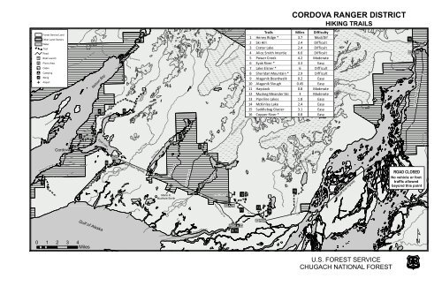
CORDOVA RANGER DISTRICT - USDA Forest Service
CORDOVA RANGER DISTRICT - USDA Forest Service
CORDOVA RANGER DISTRICT - USDA Forest Service

Create successful ePaper yourself
Turn your PDF publications into a flip-book with our unique Google optimized e-Paper software.
Simpson Bay<br />
")5<br />
")10 ")15<br />
")20<br />
<strong>CORDOVA</strong> <strong>RANGER</strong> <strong>DISTRICT</strong><br />
HIKING TRAILS<br />
Trails<br />
Miles Difficulty<br />
<strong>Forest</strong> <strong>Service</strong> Land<br />
1 Heney Ridge * 3.7 Mod/Dif<br />
Other Land Owners<br />
2 Ski Hill 2.4 Difficult<br />
Water<br />
Trail<br />
3 Crater Lake 2.4 Difficult<br />
Road<br />
4 Alice Smith Intertie * 6.6 Difficult<br />
!y Boat Launch<br />
5 Power Creek 4.2 Moderate<br />
!5 Picnic Area<br />
6 Eyak River * 3.3 Easy<br />
!= Cabin<br />
7 Lake Elsner * 6 Difficult<br />
!9 Camping<br />
8 Sheridan Mountain * 2.9 Difficult<br />
!( Sking<br />
9 Alaganik Boardwalk 0.2 Easy<br />
o Airport<br />
10 Alaganik Slough 0.45 Easy<br />
!=<br />
11<br />
12<br />
Haystack<br />
Muskeg Meander Ski<br />
0.8<br />
3<br />
Moderate<br />
Moderate<br />
13 Pipeline Lakes 1.8 Easy<br />
14 McKinley Lake 2.4 Easy<br />
4<br />
!5<br />
5<br />
15 Saddlebag Glacier 3.1 Easy<br />
16 Copper River * 0.8 Easy<br />
3<br />
2<br />
7<br />
k o<br />
8<br />
!y !_<br />
6<br />
1<br />
o<br />
15<br />
Merle K.<br />
Snag Lake Rd<br />
12 !(<br />
Mudhole Smith<br />
!=<br />
!_ ÆQ !5<br />
13<br />
11<br />
14<br />
!=<br />
!_ !5 !y<br />
!5 !y ÆQ !_<br />
9 10<br />
!=<br />
Whitshed Road<br />
Orca R d<br />
Cordova<br />
Nelson Bay<br />
Gulf of Alaska<br />
Power Creek Rd<br />
Eyak Lake<br />
iver<br />
Eyak R<br />
Ib eck Creek<br />
Copper River Highway<br />
Elsner River<br />
Cabin Lake Road<br />
Sheridan Glacier Rd<br />
AlaganikSlough<br />
Alaganik Slough Rd<br />
Scott Glacier<br />
Sheridan Glacier<br />
Sherman Glacier<br />
Saddlebag Glacier<br />
Saddlebag Glacier Rd<br />
")25<br />
Goodwin Glacier<br />
")30<br />
Copper River Highway<br />
Childs Glacier<br />
")35<br />
16<br />
!_ !9 !5<br />
")40<br />
Copper River Highway<br />
¹<br />
!y<br />
ROAD CLOSED<br />
No vehicle or foot<br />
traffic allowed<br />
beyond this point<br />
")45<br />
U.S. FOREST SERVICE<br />
CHUGACH NATIONAL FOREST
(1) HENEY RIDGE TRAIL<br />
Location: Whitshed Road mile 5.1<br />
Elevation: 50 ft - 1850 ft (15m - 563m)<br />
Length: 3.7 miles (5.9 km) Time: 5.5 hours r/t<br />
Recommended Season: Summer, Fall Use: Medium<br />
Difficulty: Moderate/Difficult<br />
USGS Map(s): <strong>CORDOVA</strong> (B-5 & C-5)<br />
The first section of trail follows the contour of Hartney Bay and offers<br />
excellent birdwatching and wildlife spotting opportunities. Spawning<br />
salmon may also be viewed from mid-July to August. The first mile of<br />
trail is a “17(b)” easement.* The next two miles moderately climb<br />
through spruce-hemlock forest and muskeg areas scattered with wildflowers.<br />
The last mile is a steep climb onto Heney Ridge following rock<br />
cairns above treeline. Once on the ridge you are treated to spectacular<br />
views of the Copper River Delta, the Prince William Sound, and Kayak<br />
Island (on clear days). There are many unique wood structures to<br />
assist hikers with traversing the varied terrain. The trail is muddy and<br />
wet in places, especially after heavy rain.<br />
(2) SKI HILL TRAIL (City trail)<br />
Location: End of 6th Street at base of ski hill<br />
Elevation: 400 ft - 2506 ft (120m - 763m)<br />
Length: 2.4 miles (3.8 km) to top of Mt. Eyak Time: 4.5 hours r/t<br />
Recommended Season: Summer, Fall Use: Heavy<br />
Difficulty: Difficult USGS Map(s): <strong>CORDOVA</strong> (C-5)<br />
The first mile and a half of this trail leads the hiker uphill over open<br />
rocky slopes, muskeg meadows, and spruce forest while offering incredible<br />
views of Orca Inlet and Eyak Lake. The trail then splits leaving<br />
a choice between walking around the south end of Mt. Eyak (approx<br />
1.5 miles) to connect with the USFS Crater Lake Trail (3), or making<br />
the steep climb to the top for an excellent panoramic view.<br />
(3) CRATER LAKE TRAIL<br />
Location: Power Creek Road mile 1.5<br />
Elevation: 40 ft - 1500 ft (12 m - 457m)<br />
Length: 2.4 miles (3.9 km) Time: 4.5 hours r/t<br />
Recommended Season: Summer, Fall Use: Heavy<br />
Difficulty: Difficult USGS Map(s): <strong>CORDOVA</strong> (C-5)<br />
This trail climbs a steep grade passing through mature sprucehemlock<br />
forest to a picturesque alpine bowl where Crater Lake sits.<br />
The first half climbs over rough, rocky sections with numerous switchbacks,<br />
and muddy areas as well as wood bridges. The second half<br />
continues to climb, but at a gentler grade, through hillsides that are<br />
abundant with wildflowers during the summer months. A bench is<br />
provided midway up the trail for a great view of Eyak Lake. At 1.2<br />
miles an intertie provides access to the Eyak Ski Hill Trail (2). At the<br />
lake the hiker has the option to access the Alice Smith Intertie (4) or<br />
climb Mt. Eyak. The entire loop from Crater Lake trailhead to Power<br />
Creek trailhead is 12 miles (approximate time is 10 - 12 hours).<br />
(4) ALICE SMITH INTERTIE<br />
Access #1: Via end of Crater Lake Trail (2.4 mile)<br />
Access #2: Via Power Creek Trail (3.0 mile)<br />
Elevation: From Crater Lake to Power Creek<br />
1500 ft - 450 ft (457 m - 137 m), Ridge top 2000 ft.<br />
Length: 6.6 miles (10.6 km) Time: 5 hours o/w<br />
Recommended Season: Summer, Fall Use: Medium<br />
Difficulty: Difficult USGS Map(s): <strong>CORDOVA</strong> (C-5)<br />
This ridge route is marked with rock cairns and has extraordinary<br />
views of Prince William Sound, Eyak Lake, the Copper River Delta,<br />
and the surrounding Chugach Mountains. Approximately halfway<br />
on the ridge, a small shelter (amenities not included) is available for<br />
day-use or overnight camping on a first-come-first-serve basis. There is<br />
excellent berry picking along the loop as well as good possibilities of<br />
viewing bears and mountain goats. Be aware of dense fog that can<br />
obscure the trail. The entire loop from Crater Lake trailhead to Power<br />
Creek trailhead is 12 miles (approximate time is 10 - 12 hours).<br />
(5) POWER CREEK TRAIL<br />
Location: End of Power Creek Road mile 6.9<br />
Elevation: 200 ft - 600 ft (61 m - 91 m)<br />
Length: 4.2 miles (6.8 km) Time: 6 hours r/t<br />
Recommended Season: Summer, Fall Use: Heavy<br />
Difficulty: Moderate USGS Map(s): <strong>CORDOVA</strong> (C-5)<br />
This trail follows the river through Power Creek drainage, then leads<br />
the hiker up several switchbacks. Midway, at the beginning of Surprise<br />
Valley, the recently built Cordova Electric Hydropower Dam can be<br />
seen. The last half of the trail follows the creek up the Power Creek<br />
Basin, passing by several beaver ponds and hanging glaciers to the<br />
Power Creek Cabin**. The cabin site has wonderful panoramic views<br />
of the valley and surrounding mountains. At mile 3.0 the Alice Smith<br />
Intertie accesses the Crater Lake Trail. The entire loop from Power<br />
Creek trailhead to Crater Lake trailhead is 12 miles.<br />
(6) EYAK RIVER TRAIL<br />
Location: Copper River Highway mile 5.7<br />
Elevation: 60 ft - 20 ft (18 m - 6 m) Time: 5 hours r/t<br />
Length: 3.3 miles (5.3 km) Use: Medium<br />
Recommended Season: Spring, Summer, Fall<br />
Difficulty: Easy USGS Map(s): <strong>CORDOVA</strong> (C-5)<br />
This trail follows the west bank of the Eyak River for one quarter<br />
mile through mature Sitka spruce forest before opening into rolling<br />
muskeg meadows. At mile 1.5 the trail reunites with Eyak River for the<br />
remainder of the distance before reaching Mountain Slough. At the<br />
end of the trail the flora composition changes to a typical delta habitat<br />
of dense alder and grasses. This is a popular access site for anglers<br />
during the coho salmon season from August to mid-September. The<br />
trail is muddy and wet in places, especially after heavy rain. Portions<br />
of this trail are “17(b)” easements.*<br />
(7) LAKE ELSNER TRAIL<br />
Location: Via Copper River Highway to mile 12.1. Turn north<br />
on Cabin Lake Road. Follow main road 2.8 miles to the end.<br />
Elevation: 200 ft - 300 ft (61 m - 91 m)<br />
Length: 6.0 miles (9.7 km) Time: 9 hours r/t<br />
Recommended Season: Summer, Fall Use: Light<br />
Difficulty: Difficult USGS Map(s): <strong>CORDOVA</strong> (C-4)<br />
This lightly sloping trail parallels the east side of the Scott Valley and<br />
passes the shores of several small and large lakes. The trail passes<br />
through previously logged areas with little maintenance work from<br />
beginning to end. The entire trail is a “17(b)” easement.*<br />
(8) SHERIDAN MOUNTAIN TRAIL<br />
Location: Via Copper River Highway to mile 13.7. Turn north<br />
on Sheridan Glacier Rd. Follow main road 4.3 miles to the end.<br />
Elevation: 200 ft - 2280 ft (61 m - 694 m)<br />
Length: 2.9 miles (4.7 km) Time: 4.5 hours r/t<br />
Recommended Season: Summer, Fall Use: Light<br />
Difficulty: Difficult USGS Map(s): <strong>CORDOVA</strong> (C-4)<br />
This moderately-steep trail begins in a spruce-hemlock forest and<br />
follows a stream that provides resting spots with views of waterfalls.<br />
Midway, the landscape transitions into a shrub habitat before opening<br />
into a small picturesque alpine basin. From this basin rock cairns guide<br />
the hiker to the top of a nearby ridge that offers commanding views of<br />
the Sheridan and Sherman Glaciers, as well as, the Copper River Delta.<br />
This trail has intermittent boardwalk covering much of the wet, muddy<br />
areas in the lower sections, and little tread work on the upper sections.<br />
The first 1.9 miles is a “17(b)” easement.*<br />
r/t - round trip o/w - one way<br />
<strong>Forest</strong> <strong>Service</strong> regulations prohibit the use of motorized<br />
vehicles on these trails to prevent excessive soil erosion<br />
and to provide a safer, more desirable foot trail for hikers.<br />
(9) PETE ISLIEB MEMORIAL<br />
(ALAGANIK) BOARDWALK<br />
Location: Via Copper River Highway to mile 16.9. Turn south<br />
on Alaganik Slough Rd. Follow main road 3 miles to the end.<br />
Elevation: 50 ft (15m)<br />
Length: 900 ft (300 m) Use: Heavy<br />
Recommended Season: Year round<br />
Difficulty: Easy USGS Map(s): <strong>CORDOVA</strong> (B-4)<br />
This wheelchair accessible boardwalk crosses an area of delta adjacent<br />
to Alaganik Slough. It then leads to an elevated viewing platform<br />
that provides a unique perspective of the delta and views of the Chugach<br />
Mountains. Interpretive signs provide information on the delta<br />
wildlife and habitat. There are excellent birdwatching opportunities<br />
in early summer. The Alaganik Recreation Area includes: 5<br />
picnic sites (1 accessible), restrooms, bear proof trashcans, parking<br />
areas, and information panels.<br />
(10) ALAGANIK SLOUGH TRAIL<br />
Location: Via Copper River highway to mile 16.9. Turn south<br />
on Alaganik Slough Rd. Follow main road 2.9 miles. Trail<br />
head is on East side of road.<br />
Elevation: 50 ft (15 m) Time: 40 min r/t<br />
Length: .45 mile (.3 km) Use: Medium<br />
Recommended Season: Spring, Summer, Fall<br />
Difficult: Easy USGS Map(s): <strong>CORDOVA</strong> (B-4)<br />
The first half is made of GeoBlock, a hard plastic material allowing<br />
the hiker to walk over the fragile wetlands without negative impact<br />
on vegetation and soil. Midway, a split log bridge provides easy crossing<br />
over a narrow stream. The last half is boardwalk following the<br />
bank of the Alaganik Slough, and ends at a bench offering hikers a<br />
place to sit and relax. In June wildflowers are abundant, especially<br />
irises. This is a popular access site for anglers during the coho salmon<br />
season from August to mid-September. Interpretive signs provide<br />
information on the natural cycles of the delta.<br />
(11) HAYSTACK TRAIL<br />
Location: Copper River Highway mile 19.2<br />
Elevation: 50 ft - 150 ft (15 m - 45 m) Time: 1.2 hours r/t<br />
Length: .8 miles (1.3 km) Use: Medium<br />
Recommended Season: Spring, Summer, Fall<br />
Difficulty: Moderate USGS Map(s): <strong>CORDOVA</strong> (B-4)<br />
This short, mostly boardwalk trail winds through spruce-hemlock<br />
forest to a knoll overlooking the Copper River Delta. From this spectacular<br />
vantage point one may view the Gulf of Alaska, Kayak Island<br />
and many species of wildlife, especially trumpeter swans and moose.<br />
The trail has several log staircases. Benches on the trail and at the<br />
end offer a place to rest and relax.<br />
(12) MUSKEG MEANDER SKI TRAIL<br />
Location: Copper River Highway mile 18.8<br />
Elevation: 50 ft - 350 ft (15 m - 105 m)<br />
Length: 3.0 miles (4.8 km) Use: Light<br />
Recommended Season: Winter<br />
Difficulty: Moderate USGS Map(s): <strong>CORDOVA</strong> (B-4)<br />
This cross-country ski trail weaves through many muskegs and short<br />
sections of forest. It gains elevation gradually and ends in a high muskeg<br />
overlooking the Copper River Delta, Heney Range, and the Gulf<br />
of Alaska. The trail is very wet during spring, summer and fall,<br />
and is not a hiking trail.<br />
*17 (b) easements provide access to public lands, granted<br />
through ANCSA part 17(b), through privately owned lands<br />
of the Alaska Native Corporations. Please respect private<br />
property rights by staying on the trails and do not trespass.<br />
Activities in this area i.e. berry picking, picnicking,<br />
temporary camping, etc. require a permit from the Eyak<br />
Corporation (P# 424-7161).<br />
(13) PIPELINE LAKES TRAIL<br />
Access #1: Copper River Highway mile 21.4<br />
Access #2: Via McKinley Lake Trail<br />
Elevation: 50 ft - 100 ft (15 m - 30 m) Time: 2.7 hours r/t<br />
Length: 1.8 miles (2.9 km) Use: Medium<br />
Recommended Season: Spring, Summer, Fall<br />
Difficulty: Easy USGS Map(s): <strong>CORDOVA</strong> (B-4)<br />
Most of this trail is boardwalk. The first 3/4 mile passes through dense<br />
spruce-hemlock forest before opening up into muskeg meadows that<br />
offer impressive views of the Chugach Mountains. Short spur trails<br />
provide fishing access to five small lakes with populations of cutthroat<br />
trout up to 12 inches in length. At the junction with the McKinley<br />
Lake trail there is an option of returning to the highway or continuing<br />
north to McKinley Lake cabin.<br />
(14) McKINLEY LAKE TRAIL<br />
Access #1: Copper River Highway mile 21.6<br />
Access #2: Via Pipeline Lakes Trail<br />
Elevation: 50 ft - 60 ft (15 m - 18 m) Time: 3.6 hours r/t<br />
Length: 2.4 miles (3.9 km) Use: Heavy<br />
Recommended Season: Spring, Summer, Fall<br />
Difficulty: Easy USGS Map(s): <strong>CORDOVA</strong> (B-4)<br />
This well-maintained trail winds its way through mature sprucehemlock<br />
forest and ends at the north end of McKinley Lake. Several<br />
bridges allow hikers easy crossing over small streams. This trail also<br />
provides access to two public use recreation cabins: McKinley Trail<br />
Cabin **(100 yards beyond the trailhead sign); and McKinley Lake<br />
Cabin ** at the end of the trail. A rough, unmaintained trail continues<br />
and for 1/4 mile past the lake cabin accesses the remains of the<br />
Lucky Strike Mine. Interpretive signs guide the visitors through the<br />
history and remains of the abandoned mine and mining camp. Midway,<br />
Pipeline Lakes Trail joins McKinley Trail for an optional loop.<br />
(15) SADDLEBAG GLACIER TRAIL<br />
Location: Via Copper River Highway to mile 24.6. Turn north<br />
on firewood cutting road. Trailhead is 1 mile at end of road.<br />
Elevation: 100 ft - 200 ft (30 m - 61 m)<br />
Length: 3.1 miles (5 km) Time: 4.5 hours r/t<br />
Recommended Season: year round Use: Light<br />
Difficulty: Easy USGS Map(s): <strong>CORDOVA</strong> (B-4)<br />
This well-drained, level trail winds its way through stands of<br />
cottonwood and spruce trees, and guides the hiker through a small,<br />
glaciated valley to the outlet of Saddlebag Lake. Split log bridges at<br />
several small stream crossings aide the hiker during high water periods.<br />
From the lake outlet, Saddlebag Glacier can be viewed at the far<br />
end of the lake. Mountain goats can often be spotted on the cliffs on<br />
either side. The lake usually has icebergs near the outlet.<br />
(16) COPPER RIVER TRAIL<br />
Location: Copper River Highway mile 48 at Million Dollar<br />
Bridge Information area.<br />
Elevation: 200 ft (61 m) Time: 1 hour r/t<br />
Length: 0.8 miles (1 km)<br />
Recommended Season: Summer, Fall<br />
Difficulty: Easy USGS Map(s): <strong>CORDOVA</strong> (C2 & 3)<br />
WARNING: Due to an unstable bridge at 36 mile on the Copper<br />
River Highway, the Dept. of Transportation is not allowing any<br />
vehicles or foot traffic beyond this point. This trail follows an old<br />
road along the Copper River where excellent views of the glacier can<br />
be seen at many sections. The hiker first enters thick vegetation, then<br />
parallels the river until reaching the Childs Glacier Recreation Area.<br />
**Cabins are available for use through the National<br />
Recreation Reservation <strong>Service</strong>: www.ReserveUSA.com<br />
1-877-444-6777.