Ch. 8 SGP
Ch. 8 SGP
Ch. 8 SGP

You also want an ePaper? Increase the reach of your titles
YUMPU automatically turns print PDFs into web optimized ePapers that Google loves.
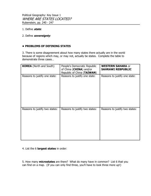
Political Geography: Key Issue 1<br />
WHERE ARE STATES LOCATED?<br />
Rubenstein, pp. 240 - 247<br />
1. Define state:<br />
2. Define sovereignty:<br />
● PROBLEMS OF DEFINING STATES<br />
3. There is some disagreement about how many states there actually are in the world<br />
because of regions which may, or may not, actually be states. Complete the table to<br />
demonstrate three cases…<br />
KOREA (North and South)<br />
People’s Democratic Republic<br />
of <strong>Ch</strong>ina (CHINA) and/or<br />
Republic of <strong>Ch</strong>ina (TAIWAN)<br />
WESTERN SAHARA or<br />
SAHRAWI REBPUBLIC<br />
Reasons to justify one state: Reasons to justify one state: Reasons to justify one state:<br />
Reasons to justify two states: Reasons to justify two states: Reasons to justify two states:<br />
4. List the 6 largest states in order:<br />
5. How many microstates are there? What do many have in common? List 6 that you<br />
can find on a map. (If you can only find three, you’ll have to look three more up!)
● DEVELOPMENT OF THE STATE CONCEPT<br />
6. Complete the graphic organizers on the topics indicated below as they relate to the<br />
history of the concept of political states and their developments.<br />
Ancient<br />
States<br />
Early<br />
European<br />
States<br />
C O L O N I E S<br />
7. By definition, what is a colony?<br />
8. Define colonialism.<br />
9. Define imperialism.<br />
10. Summarize three reasons Europeans sought colonies.<br />
a.<br />
b.<br />
c.<br />
11. Which country had the largest empire? The second largest?
12. Use the table below to list major colonies (by modern state name) and/or regions<br />
of these two countries.<br />
Colonies of:<br />
Colonies of:<br />
13. Use the table below to contrast the basic colonial policies of these two countries.<br />
Colonial practices of:<br />
Colonial practices of:<br />
14. List the largest remaining colonies in the world.
Political Geography: Key Issue 2<br />
Why Do Boundaries Cause Problems?<br />
Rubenstein, pp. 247 - 257<br />
● SHAPES OF STATES<br />
1. Complete this table based on your reading. The text gives examples which you should list. To<br />
the right of the last column also give one or your own examples.<br />
SHAPES<br />
EXAMPLES<br />
compact its greatest advantage . . .<br />
elongated two biggest problem . . .<br />
prorupted<br />
Reasons for prorupting the shape of a state...<br />
1)<br />
2)<br />
perforated<br />
how is the “perforator” state dependent on the<br />
“perforatee”?<br />
fragmented two different kinds . . .<br />
1)<br />
2)<br />
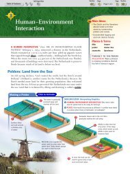
LANDLOCKED STATES<br />
2. Where are most of the world’s landlocked<br />
states?<br />
3. Why there?<br />
4. What problems do landlocked states have?<br />
5. Shade and label all of Africa’s landlocked states.
Landlocked Sates in Southern Africa<br />
“Zimbabwe’s particularly delicate problem can be understood by looking back<br />
about three decades, when it was a British colony called Southern Rhodesia. When the<br />
white minority in this landlocked colony unilaterally declared itself the independent<br />
country of Rhodesia in 1965, most other countries reduced or terminated trade with it.<br />
But the impact of trade sanctions on Rhodesia was limited because its major seaports<br />
were in South Africa, also ruled by a white minority government. As shown in Figure<br />
[8-10, updated for 10 th edition], Rhodesia’s main rail line ran through black-ruled<br />
Botswana to reach South Africa. Botswana was not cooperative, so the Rhodesian<br />
government completed a new rail line directly to South Africa in 1974, bypassing<br />
Botswana.<br />
The white-minority government of Rhodesia agreed in 1979 to give blacks the<br />
right to vote, and blacks were elected to lead the government. The following year,<br />
Britain formally recognized the independence of the country, which was renamed<br />
Zimbabwe. The Zimbabwe government, now controlled by the black majority, faced a<br />
new set of relationships in southern Africa. Instead of working closely with South<br />
Africa, Zimbabwe tried to reduce its dependency on the neighboring white-minority<br />
government. The key element in Zimbabwe’s strategy was to use railroads that<br />
connected to seaports outside South Africa. That turned into a very complex problem.<br />
Reference to Figure [8-10, updated for 10 th edition] will make this explanation easier<br />
to follow.<br />
The closest seaport to Zimbabwe is Beira, in Mozambique. A railroad known as<br />
the Beira corridor runs west from the seaport to the Zimbabwean capital of Harare.<br />
Between 1976 and 1992, however, Mozambique was caught in a devastating civil war<br />
between its Marxist-oriented government and rebels backed by South Africa.<br />
Zimbabwe sent soldiers to Mozambique to keep the 500-kilometer (300-mile) Beira<br />
corridor repaired and protected from rebel attack, but the seaport of Beira itself was<br />
not well maintained.<br />
More distant seaports were not reliable either. Mozambique’s other two major<br />
deep-water ports—Nacala in the north and Maputo in the south—suffered even more<br />
than Beira from the civil war. The Benguela railway, which runs from the Atlantic<br />
Coast eastward across Angola to Zaire and Zambia, has also been disrupted since 1975<br />
by a civil war in Angola.<br />
The Tazara line, which runs from Zambia to Dar es Salaam in Tanzania, remains<br />
open, but service is unreliable. The equipment, much of it supplied by the <strong>Ch</strong>inese in<br />
the 1970s, frequently breaks down, and landslides have periodically closed the line. As<br />
a result of these obstacles, Zimbabwe ships more than half of its freight through the<br />
South African port of Durban.”<br />
Source: The Cultural Landscape, 7 th Ed.
CASE STUDY: Zimbabwe’s access problems<br />
6. In what different ways has Zimbabwe historically had access to seaports?<br />
7. What specific obstacles has each<br />
presented? (Note: Some obstacles<br />
were ideological.)<br />
8. Label the countries surrounding Zimbabwe. Do not show all rail routes shown on<br />
page 250, but only those discussed in the reading as part of Zimbabwe’s history of<br />
attempts to reach the sea through her neighbors.<br />
● TYPES OF BOUNDARIES<br />
PHYSICAL BOUNDARIES<br />
9. Complete the table below to describe the advantages of each type of physical<br />
boundary.<br />
deserts mountains water (rivers)
CULTURAL BOUNDARIES<br />
10. What are three types of cultural boundaries which have often been used? Give an<br />
example of each.<br />
type of cultural boundary<br />
a.<br />
describe an example<br />
b.<br />
c.<br />
CASE STUDY: CYPRUS<br />
11. Bullet in the most significant facts regarding the boundary and ethnic situation in<br />
Cyprus. Annotate the map as appropriate.<br />
12. Regarding the concept of a frontier…<br />
a. define it:<br />
b. list the characteristics of frontiers:
● BOUNDARIES INSIDE STATES<br />
13. Define the following types of internal organization of states:<br />
a. Unitary State<br />
b. Federal State<br />
14. Regarding unitary states, what are the two geographic conditions that tend to<br />
favor it for a country?<br />
a.<br />
b.<br />
15. Where are unitary states most common?<br />
16. Regarding federal state, what are three geographic conditions that tend to favor<br />
it for a country?<br />
a.<br />
b.<br />
c.<br />
17. List good examples of federal states which fulfill these conditions rather well.<br />
18a. Why has tiny Belgium adopted a federal system?<br />
18b. Why has enormous <strong>Ch</strong>ina adopted a unitary system?<br />
19. Multinational states often adopt unitary systems for what reason? Also, describe<br />
an example where this has occurred.
CASE STUDY: FRANCE<br />
20. Describe the internal political organization France in the box below.<br />
FRANCE: Internal Political<br />
Organization<br />
ELECTORAL GEOGRAPHY<br />
21. Why are the boundaries of legislative districts occasionally redrawn? How often is<br />
this done in the US?<br />
22. How is this type of boundary redrawing different in the US than in Europe?<br />
23. What is gerrymandering?<br />
24. What are the three types of gerrymandering?<br />
i.<br />
ii.<br />
iii.<br />
25. How is gerrymandering combined with ethnicity for political
Political Geography: Key Issue 3<br />
Why Do States Cooperate With Each Other?<br />
Rubenstein, pp. 257 - 260<br />
● POLITICAL AND MILITARY COOPERATION<br />
1. When was the United Nations established? By whom?<br />
2. Identify the reason for which membership in the UN grew significantly in each of<br />
the following periods:<br />
(a) 1955<br />
(b) 1960<br />
(c) 1990’s<br />
3. Who are the five permanent members of the Security Council?<br />
4. Identify some of the problems the UN faces as it attempts to operate and influence<br />
world affairs.<br />
REGIONAL MILITARY ALLIANCES<br />
5. Why is the idea of only two superpowers a relatively new one?<br />
6. Define balance of power:<br />
7. Describe the purpose of NATO.
8. Describe the purpose of the former “Warsaw Pact” countries.<br />
9. List 4 facts about the OSCE.<br />
1)<br />
2)<br />
3)<br />
4)<br />
10. Complete the chart on notable non-military regional organizations.<br />
Regional Organization Members Purpose<br />
OAS<br />
Organization of<br />
American States<br />
AU<br />
African Union<br />
REGIONAL ORGANIZATIONS<br />
The Commonwealth<br />
● ECONOMIC COOPERATION<br />
11. What states have joined the “superpowers” based on their economic success?<br />
What former power has “slipped” from its earlier status?<br />
12. The leading (economic) superpower since the 1990s is not a single state. What is<br />
the leading (economic) superpower in the world today?
13. Regarding the European Union….<br />
(a) when was it formed?<br />
(b) by what states?<br />
(c) for what purpose?<br />
(d) what are some important changes in recent years?<br />
(e) what former Communist East European states have begun the process of<br />
joining the EU?<br />
(f) why these – what separated them from the others?
Political Geography: Key Issue 4<br />
Why Has Terrorism Increased?<br />
Rubenstein, pp. 260 - 268<br />
1. What is terrorism, by definition?<br />
2. List typical methods/acts of terrorists?<br />
3. Why is terrorism different from other acts of political violence?<br />
● TERRORISM BY INDIVIDUALS AND ORGANIZATIONS<br />
4. List places in which Americans were attacked by terrorists in the late 20 th century.<br />
5. Identify each of the following terms as they relate to the terrorist organizations known as Al-<br />
Qaeda.<br />
(a) Osama bin-Laden<br />
(b) “the base”<br />
(c) Afghanistan<br />
(d) Yemen and Somalia<br />
(f) fatwa<br />
6. In what ways does Al-Qaeda, its religious and political views, and its methods pose a challenge<br />
to…<br />
i. Muslims?<br />
ii. Americans?
Iran<br />
Iraq<br />
Afghanistan<br />
Libya<br />
● STATE SUPPORT FOR TERRORISM<br />
7. List the three ways in which states (particularly in the Middle East in recent decades) have<br />
given support to terrorists.<br />
a)<br />
b)<br />
c)<br />
8. Note in which of the above ways each of the following states has supported terrorism and<br />
then very briefly describe it.<br />
STATE<br />
type of support<br />
(from question #7)<br />
summary of issues