Excavations at Wallingford, 1974 - Oxoniensia
Excavations at Wallingford, 1974 - Oxoniensia
Excavations at Wallingford, 1974 - Oxoniensia

Create successful ePaper yourself
Turn your PDF publications into a flip-book with our unique Google optimized e-Paper software.
<strong>Excav<strong>at</strong>ions</strong> <strong>at</strong> <strong>Wallingford</strong>, <strong>1974</strong><br />
By T. J. WEARE<br />
INTRODUCTION<br />
T<br />
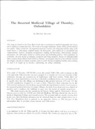
HE site of the excav<strong>at</strong>ion \SU608589'7) is loc<strong>at</strong>ed in the south-east corner of<br />
<strong>Wallingford</strong>, Oxfordshire, approxim<strong>at</strong>ely 25 m. south of the supposed site of<br />
the church of St. Michael (FIG. 1). It is bounded on the north by New Road, on<br />
the ('ast by Thames Street, on the south by houses on Cherwell Crescent and by a<br />
house called the Rectory on the west.<br />
In '972 planning permission was granted for the construction of twO houses on<br />
the site. Rescue excav<strong>at</strong>ion was carried out between April and December '974·<br />
The work was performed by members of the <strong>Wallingford</strong> Historical and Archaeological<br />
Society under the supervision of ~liss P. A. E. Granados and Dr. T. J.<br />
Weare. Professional guidance and supervision through the course of the excav<strong>at</strong>ion<br />
were provided by :"11'. T. G. Hassall of the Oxfordshire Archaeological Unit. The<br />
detailed records, plans and finds of the excav<strong>at</strong>ion will be kept in the Oxfordshire<br />
County Council Dept. of ~luseum Services, Woodstock.<br />
The geology of the site is un~omplic<strong>at</strong>ed. <strong>Wallingford</strong> lies wholly in the<br />
gravel terrace of the present flood plain of the river Thames.'<br />
An extensive study of the documentary evidence rel<strong>at</strong>ing to <strong>Wallingford</strong> was<br />
published in the last century,' with a number of references relevant to the New<br />
Road site. Unfortun<strong>at</strong>dy the d<strong>at</strong>e of the founding of the church of SI. ~lichael<br />
is not recorded. The earliest reference' to this church is a parchment deed, in<br />
L<strong>at</strong>in, limp. Henry III, which refers to a property in the parish of SI. ~lichael. The<br />
names of some of the incumbents of SI. ~[ichael's arc recorded' for the period '33 0<br />
to 1348. In '374 the church was united to SI. Peter's, <strong>Wallingford</strong>.'<br />
The section of Thames Street bordering the site of the excav<strong>at</strong>ion is believed to<br />
have formed part of the original Saxon street plan.' New Road was constructed in<br />
the l<strong>at</strong>e eighteenth century <strong>at</strong> the instance of Sir William Blackstone.' The Ordnance<br />
Surve}' of 1877 shows the site as the garden of the' Rectory'.<br />
TilE EXCAVATION<br />
Excav<strong>at</strong>ion was restricted to the garden areas of the proposed development to<br />
avoid having to reinst<strong>at</strong>e the ground. This effectively limited the investig<strong>at</strong>ion to<br />
two trench(,s, trench I (3 x 4 m.) in the north-east corner of the site, and trench II<br />
rD. Benson and D. Miles. Tht l..rppn Thamts Vallo': n1l arrll(tr%gicol Jurt'~)' of the riL,tr{!rmels <strong>1974</strong>1.<br />
1 J, K. Hedg('s. Tht History oj 11 'allinlford ( 188 . .<br />
J Ibid .. 1. 3+4.<br />
"lhid··11.4 15·<br />
~/bid .. 11.41:1:.<br />
6 C. Sim»§on, l1'ollilllJJord. Tht Archotoiogiwllmpll((llionl oj Dtl'tlopmrnl 1973·<br />
";" Ht"dJ(C'''' (J/I. fit. nole ~, II. .p 3·
EXCAVATIONS AT WALLDIGFORD, <strong>1974</strong><br />
205<br />
WALLINGFORD<br />
,,",,1111"11 ,,,,,....,t'''/IIII••<br />
\t~"I'f"I''''U\''IIII' \,..... ,<br />
,~\~" .'<br />
~'\.'<br />
I<br />
i<br />
i •<br />
•<br />
i<br />
E<br />
N<br />
f<br />
...<br />
~,<br />
.!:.<br />
,"'<br />
.<br />
.:'~<br />
::<br />
.-<br />
--<br />
.:<br />
"<br />
. -<br />
100m<br />
• St Mich.el's Church (site of)<br />
FIG. I<br />
Loc<strong>at</strong>ion plan.
206 T. J. WEARE<br />
(3 x 4'5 m. irutially, l<strong>at</strong>er extended) on the south side of the site. A system of metric<br />
coordin<strong>at</strong>ion was used to record positions in plan. Levels recorded in both trenches<br />
were referred to the same d<strong>at</strong>um, a fixed point outside the site. This d<strong>at</strong>um was<br />
reduced to Ordnance D<strong>at</strong>um through a permanent bench mark.<br />
To maintain as much control as possible each trench was divided into quadrants<br />
and excav<strong>at</strong>ion altern<strong>at</strong>ed between diagonal pairs of quadrants until a fe<strong>at</strong>ure or<br />
layer was identified.<br />
NEW ROAD<br />
18/111<br />
SCALE<br />
i.Fili I I<br />
0 2 1 ~ 5 6 7 8 9 10 Metres<br />
Tronch I<br />
....<br />
'"<br />
Q:<br />
....<br />
V}<br />
21/105<br />
Trench 1<br />
I--<br />
N<br />
\<br />
l-<br />
r<br />
V}<br />
'" l:<br />
...<br />
:to<br />
....<br />
20/100<br />
I--<br />
b~se line<br />
'0(100<br />
FtG. !2<br />
Plan of site showing position of trenches, base line, etc.<br />
Period 1.' Pre-burial phase (?twelfth/thirteenth century A.D.)<br />
Trench I. Two pits were found, each approxim<strong>at</strong>ely 1'5 m. diameter, I m. deep<br />
(one = 26 on FIG. 3).<br />
Trench II. A chalk, mortar and flint layer (230 in FIG. 4) in the south-west corner<br />
was cut by an articul<strong>at</strong>ed inhum<strong>at</strong>ion and by the Period 2 bell-pit described below.<br />
Little can be said about the trench I pits, as they were in the north·east and south-west<br />
corners of the trench and could only be partly excav<strong>at</strong>ed. It is unlikely th<strong>at</strong> they were<br />
rubbish pits because they contained very little debris, and they may have been dug to<br />
extract gravel. They pre-d<strong>at</strong>ed use of the site for burials as there were inhum<strong>at</strong>ions above<br />
them.<br />
The layer of chalk etc. in trench II is thought to have been a spread of building<br />
debris although no evidence of footings or of a robber trench was found.
EXCAVATIONS AT WALLINGFORD, '974<br />
38/t09<br />
WeST SeC nON TReNCH I<br />
~-------------------------------_I<br />
2o'hcontury -1r=====-------~~--J.~·~~~.':tP~oIK:j-:3.. i;
208 T. J. WEARE<br />
r_-:-...,-TI!."
"6.00ml A<br />
ODN -I<br />
EXCAVATIONS AT WALLINGFORD, <strong>1974</strong><br />
NOR TH - SOUTH SEC TlON (A- C)<br />
THROUGH THE BELL PIT<br />
B<br />
•<br />
I" Ch"lk&Flint 221<br />
---------_ .c::=J_<br />
/j<br />
Present ground "<br />
level<br />
i<br />
I<br />
o<br />
Sc .. le<br />
W<strong>at</strong>er table<br />
(1"'~:~~\<br />
1m<br />
Dark stony soil<br />
227<br />
;;0----,<br />
-<br />
Soil tinged red<br />
-small<br />
stones<br />
Layer of large<br />
flints + ash<br />
. e '" •••• • : •<br />
:',_:e'.' ..• '<br />
N<strong>at</strong>ural gravel<br />
PIG. 6<br />
North-south section through the bell-pit in trench II.<br />
. ?Fired<br />
Hf--+t--'-' cl~<br />
Dark<br />
soil<br />
According to Theophilus the basic steps in the process were as follows:<br />
(I) construct Ihe bell mould<br />
(2) dig the pit<br />
(3) lay a found<strong>at</strong>ion of stones in the base of the pit<br />
(4) back fill the pit<br />
(5) place the bell mould over the centre of the pit and re-excav<strong>at</strong>e the pit, thereby<br />
lowering the mould on to the found<strong>at</strong>ion<br />
(6) construct a kiln around the mould and fire it<br />
(7) when firing is complete quickly remove the kiln surround and fill the space<br />
between the mould and the pit wall with earth to support the mould<br />
(8) raise the cast bell by reversing the steps in 5.<br />
The fact th<strong>at</strong> the pit was first dug (in the n<strong>at</strong>ural gravel) and then back filled to lower<br />
the mould explains the thickness of earth between the n<strong>at</strong>ural gravel (the original pit)<br />
and the darkened pit lining (the re-excav<strong>at</strong>ed pitl-see FIG. 6. The layer of large flints<br />
found in the bottom presumably formed the found<strong>at</strong>ion on which the bell mould rested.<br />
The lining of the pit was blackened by the he<strong>at</strong> from the kiln. No trace of the kiln or bell<br />
mould was found. According to Theophilus' both would have been removed completely<br />
from the pit before the mould was broken to release the bell.
2 10<br />
T. J . WEARE<br />
38/113<br />
\ ..,<br />
.. ...<br />
..... ~ 14<br />
.... ;... Q~C1ofJJ \)0<br />
~/int-lined grave<br />
():p..:.
EXCAVATIONS AT WALLINGFORD, <strong>1974</strong><br />
Period 3: Burials (thirteenth- fourteenth century A.D.)<br />
Evidence was found of approxim<strong>at</strong>ely 35 inhum<strong>at</strong>ions, all aligned east-west and<br />
nearly all disturbed, usually by l<strong>at</strong>er burials. In trench I, one grave was lined with large<br />
flints, another lined and capped with chalk blocks, the l<strong>at</strong>ter being largely cut away by a<br />
l<strong>at</strong>er pit ( 12 on FIG. 7).<br />
One find , a small bronze buckle, appeared to be associ<strong>at</strong>ed with a burial. It was<br />
found near the left shoulder of an articul<strong>at</strong>ed inhum<strong>at</strong>ion in trench II. No positive d<strong>at</strong>ing<br />
of any of the burials has been made. On the assumption th<strong>at</strong> the graveyard is th<strong>at</strong> of the<br />
church of St. Michael, the burials are probably thirteenth or fourteenth century.<br />
Period 4: Gravel/rubbish pit in trench I (seventeenth century A.D.)<br />
The southern half of trench I was cut through by a large pit, J '5 to 2'0 m. deep into<br />
the n<strong>at</strong>ural gravel ( FIGS. 3 and 7). A general depression in the present ground surface<br />
south of trench I suggests th<strong>at</strong> the pit extends well beyond the southern limit of the trench.<br />
It would seem almost certain th<strong>at</strong> the pit Vvas dug originally to extract gravel. Access<br />
would have been directly from Thames Street.<br />
The various layers in the fill of the pit indic<strong>at</strong>e th<strong>at</strong> it was subsequently used as a<br />
rubbish pit or tip. A number of clay pipe bowls and stems were found in these layers,<br />
some l<strong>at</strong>e seventeenth century in style. This is the only firm d<strong>at</strong>ing evidence found in the<br />
gravel pit.<br />
Period 5: Garden p<strong>at</strong>h and rubbish pit (eighteenth to twentieth century A.D.)<br />
There was a rubbish pit which cut through a burial in trench II, and a gravel surfaced<br />
garden p<strong>at</strong>h passing through both trenches. The p<strong>at</strong>h is shown in the Ordnance Survey of<br />
1877. The rubbish pit, approxim<strong>at</strong>ely I m. square and J m. deep, contained about go Kg.<br />
of glass and china. A small gold ring (probably an ear-ring) hall-marked Birmingham<br />
early twentieth century, was found <strong>at</strong> the very bottom of the pit.<br />
2 I I<br />
CONCLUSIONS<br />
Limited activity on the site before its use for burials is shown by the two pits<br />
in trench I, and the mortar/flint layer in trench II. The pits were apparently not<br />
filled with rubbish, and are therefore comparable to the tenth/eleventh-century<br />
fe<strong>at</strong>ures excav<strong>at</strong>ed recently <strong>at</strong> another of King Alfred's' de novo' burhs, Wareham,<br />
Dorset.' It is not to be expected th<strong>at</strong> intense occup<strong>at</strong>ion would be found so far<br />
from the main street in the first stages of the town's history.<br />
The site presumably already belonged to a church when the large pit was dug<br />
to cast the bell (or bells). Thereafter it was a graveyard, probably to serve St.<br />
Michael's nearby, <strong>at</strong> least until th<strong>at</strong> church was amalgam<strong>at</strong>ed with St. Peter's in<br />
1374. It may have been memories of its use as hallowed ground th<strong>at</strong> restricted its<br />
subsequent development, or it may simply be th<strong>at</strong> its l<strong>at</strong>er history was typical of<br />
<strong>Wallingford</strong>'s physical decay.<br />
THE FINDS<br />
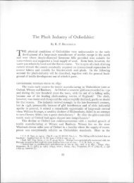
THE PO'ITERY. By R. DIXON, 1. GARDINER, and T. J. WEARE ( FIGS. 8, 9)<br />
Trench II presented the most clearly str<strong>at</strong>ified m<strong>at</strong>erial with a rel<strong>at</strong>ively undisturbed<br />
burial phase (period 3) and the backfill of the bell pit (period 2) yielding approxim<strong>at</strong>ely<br />
350 sherds each. The pottery recovered from trench I will not be discussed here; a<br />
9 Ex. inf. the Editor. To be published in Proc. Dorstt N.H. and A.S. , XCIX ( 1977) .
212 T. J. WEARE<br />
complete description and analysis of pottery from both trenches can be found with the<br />
detailed records. 1o<br />
The majority of wares were medieval, predominantly local and principally ofa sandy<br />
fabric :g2%). The following method of classific<strong>at</strong>ion devised by Maureen Mellor of the<br />
Oxfordshire Archaeological Unit, was adopted. The pottery was examined visually and<br />
classified according to the type of inclusion into three broad groups, I: limestone, II:<br />
flint and Ill: sand or no grains. The pottery was further divided according to the size,<br />
shape and abundancy of the inclusions. [n all, twenty-t'\vo distinct fabric types were<br />
identified. A careful comparison has been made with a fabric type series derived from<br />
m<strong>at</strong>erial excav<strong>at</strong>ed <strong>at</strong> <strong>Wallingford</strong> Castle," g8% of the sherds being of fabric types found<br />
there. Of the sandy wares, go% fell more or less equally into three similar fabric types.<br />
Few imports were found, a foolring of Pingsdorf type ware (No. 6,)" and a glazed body<br />
sherd of a probable Aardenberg-type," being notable exceptions. The local sandy ware<br />
was occasionally thinly glazed and/or decor<strong>at</strong>ed with a white slip (e.g. Nos. '3, 18,42,47,<br />
48)," rectangular rouletting (No. 20)" or combing (Nos. '4 and 50). Incised linear<br />
decor<strong>at</strong>ion (No. Ig) and triangular stabbings were common to handles (Nos. 18 and 49).<br />
A number of cooking-pot rims were decor<strong>at</strong>ed with thumbing (Nos. 6, 26, 3', 40, 52).<br />
Most of the rim forms from sandy wares were simple and not well developed; several of<br />
the flinty wares resemble rim forms from neighbouring sites; Nos. 35 and 36 are similar to<br />
Group B Rinty wares <strong>at</strong> Tetsworth," and No. 65 (Group II) resembles a rim sherd from<br />
Seacourt. 17 Three different forms of tripod pitcher feet were found; Nos. 43 and 45 can<br />
be paralleled with types from Reading Abbey." An unusual sherd (No. 21) is believed<br />
to have been part of a curfew handJe. 1o The hole and blackening of the interior surface<br />
support this interpret<strong>at</strong>ion. The only profile recovered was th<strong>at</strong> of a shallow dish (1 o.<br />
17), the interior surface of which was glazed. Two examples of applied rouletted altern<strong>at</strong>·<br />
ing red and white strips were found (No. 60).'·<br />
The' painted I or white slip wares paralleled \vilh pottery from Abingdon, Oxford and<br />
Reading Abbey are particularly interesting. These wares represent some 4% of the total<br />
wares recovered from l<strong>at</strong>c twelfth to early fourteenth-century deposits <strong>at</strong> Oxford.: 1 The<br />
higher proportion of these wares from this site and from mid thirteenth-century contexts<br />
<strong>at</strong> Reading Abbey as compared with Oxford suggest th<strong>at</strong> these wares origin<strong>at</strong>e to the south<br />
of Oxford, closer to <strong>Wallingford</strong> and Reading. The d<strong>at</strong>ing of the pottery is difficult, as<br />
well str<strong>at</strong>ified deposits from \Vallingford are as yet unknown. However, by analogy with<br />
other sites in the region, the pottery from the backfill of the bell pit (period 2) was thought<br />
to d<strong>at</strong>e to the l<strong>at</strong>e twelfth century while the majority of wares from the burial phase (period<br />
10 See above. second paragraph.<br />
II R, D. Carr. Excaootions <strong>at</strong> <strong>Wallingford</strong> Qutk. '97/J fforthcoming).<br />
The details of this pottery, record ed<br />
by Maureen Mellor. will be lodged with the Oxfordshire County Council Department of Museum Services.<br />
uG. C. Dunning dol.,' Anglo-Saxon Pottery: A symposium', M~dielJOl Archorology, UI (1959), Fig. 28,<br />
N~. 8-13.<br />
13 Similar ~herds were identified by J. G. Hurst and F, Verhaeghe, from <strong>Wallingford</strong> Castle.<br />
14 M. Parrington and C. Balkwill, • <strong>Excav<strong>at</strong>ions</strong> <strong>at</strong> Broad Street', Oxoru~nsia, XL (1975), Fig. 29, No. 67·<br />
Abingdon Fabric A includes <strong>Wallingford</strong> fabrics with while slip j M. Biddle, • Medieval Village of Seacourt "<br />
Oxonitnsia, XXV1,'XXVII (lgGl/2), Fig. 19, NO.7; C. F. Slade, • Excav<strong>at</strong>ion <strong>at</strong> Reading Abbey', Btrkshlre<br />
Archotol. J.t LXVI {1973), Fig. 11, Nos. 3-7. and 12; B. Durham, • 7g-80 St. AJd<strong>at</strong>es', (this volume), Fabric<br />
AG.<br />
IS L. R. A. Grove, • Norman Pottery from <strong>Wallingford</strong> Market Place', Btrkshire Archotol. J., L (1938),<br />
Fig. I, No. I.<br />
Ib M. Robinson, • <strong>Excav<strong>at</strong>ions</strong> <strong>at</strong> Copt Hay, Tetsworth, Oxon. " Oxonimsia, XXXVUI 1973), Fig. 19. Nos.<br />
54 and 62, d<strong>at</strong>ed as early thirteenth century.<br />
11 Biddle, op. cit, note 14. Fig. 22, No. 10, d<strong>at</strong>ed early thirteenth century.<br />
I' Slade, oj). clt. note 14. Fig. I~, Nos. 40 and 49, d<strong>at</strong>ed the first half of the thirteenth century.<br />
19 R. M. Huggins •• Pottery'J In P. J. Huggin~, • Excav<strong>at</strong>ion, <strong>at</strong> Waltham Abbey', MedUvoI ArcJuuoiogYI<br />
xx (1976). Fig. 37, No. 32.<br />
20 Biddle. op. ci/. note 14. Fig. 25, No. I. probably mid· l<strong>at</strong>e thirteenth century.<br />
II Durham, op. cit. note 14 (Phases 8 and 9).
,<br />
21<br />
1<br />
I<br />
3<br />
\.... 41 I<br />
1 51<br />
EXCAVATIONS AT WALLINGFORD, <strong>1974</strong> 213<br />
{. - =;<br />
16 1<br />
-,<br />
(<br />
I<br />
1<br />
I<br />
17<br />
)<br />
)<br />
6<br />
,<br />
5 0 em 5 10<br />
1'10.8<br />
Nos. 1-29 Group III fabric, period 2. Scale t·
214 T. J. WEARE<br />
30 65<br />
t (<br />
31<br />
- 33<br />
32<br />
34<br />
35<br />
36<br />
']1-\<br />
64<br />
63<br />
62<br />
,~ ). 61 [ ~<br />
37<br />
38<br />
39<br />
58<br />
40<br />
41<br />
. ::::~~. ···-''-7-- j /. ~<br />
~ 'h._~_~L-.---"J""'"/ 50 '0 ,-----53.,1----.,7<br />
'lIr- -=====:~l.- ... -~<br />
52<br />
46<br />
51<br />
~ red ~ white<br />
1'10·9<br />
5 o em 5 '0<br />
Nos. 30-34 Group III fabric, period 2; 35. 36 Group fI fabric, period 2; Nos. 37-62 Group III fabric, period 3i<br />
Nos_ 63~5 Group II, period 3- Scale i_
EXCAVATIONS AT WALLINGFORD, <strong>1974</strong> 215<br />
3) were d<strong>at</strong>ed to the early thirteenth century with a few notable exceptions (Nos. 33<br />
(Aardenberg-type), 49 and 60) which range in d<strong>at</strong>e from the mid-thirteenth to midfourteenth<br />
century.<br />
THE SMALL FINDS<br />
Some of the metal objects found included a bronze buckle (2 x 3 cm.), a lead weight<br />
(4 x '·5 x o·5 em.) and an iron arrow head (4 cm. long) from trench II, period 3, and<br />
numerous deposits of mineralised copper, iron slag, iron nails, and a bronze coin (not<br />
identified but thought to be Roman) from trench II, period 2.<br />
Other objects found include a chalk spindle whorl (3.2 em. diameter) from trench II,<br />
period I, and two worked bone needles from trench II, period 2.<br />
The Socie!J thanks the Department of the Environment for a public<strong>at</strong>ion grant for this<br />
paper.