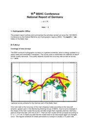
NAVIGATIONAL WARNINGS/MSI/GMDSS IN NAVAREA VIII - IHO
NAVIGATIONAL WARNINGS/MSI/GMDSS IN NAVAREA VIII - IHO
NAVIGATIONAL WARNINGS/MSI/GMDSS IN NAVAREA VIII - IHO

You also want an ePaper? Increase the reach of your titles
YUMPU automatically turns print PDFs into web optimized ePapers that Google loves.
MRCC Port Blair<br />
The Indian SRR (A&N) area covered by the MRCC Port Blair is defined<br />
by the line joining the following coordinates and IBL.<br />
(a) Coastal border between India and Bangladesh<br />
(b) 15 20N 088 30E<br />
(d) 06 00N 092 00E<br />
(c) 07 15N 088 30E<br />
(e) 06 00N 097 32E<br />
(f) Northwards of position of serial (e) given above and<br />
covering the areas outside limits of the designated areas of other<br />
littoral countries.