MAJDAL SHAMS URBAN PLANNING UNDER OCCUPATION ANALYSIS
MAJDAL SHAMS URBAN PLANNING UNDER OCCUPATION ANALYSIS
- Page 3: Analysis Diploma Thesis Majdal Sham
- Page 7 and 8: Urban Planning ....................
- Page 9 and 10: 8 9 In the summer of 2012, we accid
- Page 11 and 12: 10 11 SYRIA LEBANON GOLAN HEIGHTS I
- Page 13: 12 13 The area commonly known as th
- Page 16 and 17: THE DRUZE STAR
- Page 18 and 19: DRUZE HISTORY Kalifat DRUZE SECT fi
- Page 20 and 21: DRUZE HISTORY After capturing the O
- Page 22 and 23: DRUZE HISTORY French Mandate for Br
- Page 24 and 25: DRUZE HISTORY Golan Heights occupie
- Page 26 and 27: THE DRUZE COMMUNITY TURKEY CYPRUS M
- Page 28 and 29: NATIONAL IDENTITY + BELONGING
- Page 30 and 31: NATIONAL IDENTITY + BELONGING Druze
- Page 32 and 33: THE GOLAN DRUZE fig. 2 Syrian Indep
- Page 34 and 35: THE GOLAN DRUZE AND THEIR NON- VIOL
- Page 36 and 37: THE GOLAN DRUZE AND THEIR NON- VIOL
- Page 38 and 39: fig. 3 Demonstration on the main sq
- Page 41 and 42: 03 THE GOLAN HEIGHTS 40 41 The Gola
- Page 43 and 44: 42 43 MAJDAL SHAMS KIRYAT SHMONA BE
- Page 45 and 46: 44 45 In recent and modern history,
- Page 47 and 48: 46 47 MAJDAL SHAMS KIRYAT SHMONA BE
- Page 49 and 50: 48 49
- Page 51 and 52: Mt. Hermon / Jabal al-Shaykh 2.814
<strong>MAJDAL</strong> <strong>SHAMS</strong><br />
<strong>URBAN</strong> <strong>PLANNING</strong> <strong>UNDER</strong> <strong>OCCUPATION</strong><br />
<strong>ANALYSIS</strong>
Analysis Diploma Thesis<br />
Majdal Shams - Urban Planning under Occupation<br />
Carla Schwarz, Leonie Weber<br />
Prof. Markus Allmann, IGRE - Institut für Raumkonzeptionen und Grundlagen des Entwerfens<br />
Prof. Philipp Misselwitz, SI - Städtebau-Institut, Fachgebiet Internationaler Städtebau<br />
University of Stuttgart<br />
April 2013
Table of Content<br />
01 INTRODUCTION 01<br />
The Occupied Syrian Golan ......................................<br />
The Middle East .........................................................<br />
Tower of the Sun .......................................................<br />
02 HISTORY<br />
14<br />
The Druze Star ..........................................................<br />
Druze History ............................................................<br />
The Druze Community .............................................<br />
National Identity + Belonging ................................<br />
The Golan Druze ........................................................<br />
03 THE GOLAN HEIGHTS<br />
40<br />
The Golan Heights 2012 .........................................<br />
Border Shifts .............................................................<br />
Value ...........................................................................<br />
Before the Occupation ............................................<br />
Since the Occupation ...............................................<br />
04 POLITICAL SITUATION 72<br />
Freedom of Movement .............................................<br />
Border Crossing Groups ..........................................<br />
Majdal Shams .............................................................<br />
Points of Contact ......................................................<br />
Israeli Settlement Policy .........................................<br />
Israeli Land Policy ......................................................
Urban Planning ..........................................................<br />
Autonomous Planning ..............................................<br />
Economic Occupation ...............................................<br />
The Valley of Tears ....................................................<br />
05 <strong>MAJDAL</strong> <strong>SHAMS</strong><br />
150<br />
Majdal Shams 2012 ...................................................<br />
Historical Development 1968-2012 ......................<br />
Population ...................................................................<br />
Urban Analysis ...........................................................<br />
Spatial Limitations ....................................................<br />
06 THE FUTURE<br />
212<br />
Potentials + Weaknesses Majdal Shams ..............<br />
Future Scenarios Israel ............................................<br />
Development Directions Majdal Shams .................<br />
Scenario Majdal Shams 2040 ..................................<br />
General Scope of Action ...........................................<br />
Best + Worst Cases Majdal Shams ........................<br />
07 CONCLUSION<br />
08 BIBLIOGRAPHY +<br />
TABLE OF FIGURES<br />
228<br />
230
THE OCCUPIED SYRIAN GOLAN
8<br />
9<br />
In the summer of 2012, we accidentally came across the village<br />
of Majdal Shams and faced the whole issue of the Occupied<br />
Syrian Golan while travelling in Israel. Actually we went<br />
to the Golan Heights to visit some members of the Majdal<br />
Shams based band, Toot Ard, whom some friends of us got<br />
to know at one of their concerts in Weimar, Germany.<br />
We were invited to join them listening to a rehearsal of<br />
their befriended band, Hawa Dafi. Afterwards, we had some<br />
drinks in the very first bar in the Arab village which is today<br />
owned by one of Hawa Dafi’s members. In the evening, we<br />
had great conversations about the huge role which politics<br />
plays in the local people’s every day life and the meaning of<br />
having no national identity.<br />
After a brief research, we got in contact with Dr. Nizar Ayoub<br />
from a local NGO, Al-Marsad - the Arab Human Rights Centre<br />
in the Golan Heights, who referred us to Dr. Nazeh Brik, a<br />
local architect and urban planner, who had studied in Augsburg,<br />
Germany.<br />
We came back to Majdal Shams for one more day, talking<br />
about how strongly architecture and urban planning are interwoven<br />
with politics and military strategies in the special<br />
context of Israel and its occupied territories. Being riveted<br />
by the whole matter, we decided to visit here again in October/November<br />
with an approval of our professors for focusing<br />
more on this issue in our diploma thesis.<br />
We spent one month in Majdal Shams and were truly overwhelmed<br />
by the hospitality and openness we were confronted<br />
with during our research. We earnestly hope that<br />
our work can fairly reflect the comprehensive situation of<br />
the Occupied Syrian Golan that we are focussing on.
THE MIDDLE EAST<br />
TURKEY<br />
CYPRUS<br />
Mediterranean<br />
Sea<br />
EGYPT
10<br />
11<br />
SYRIA<br />
LEBANON<br />
GOLAN HEIGHTS<br />
IRAQ<br />
WEST-<br />
BANK<br />
GAZA<br />
ISRAEL<br />
JORDAN<br />
SAUDI<br />
ARABIA<br />
0<br />
100<br />
200<br />
500 km
TOWER OF THE SUN
12<br />
13<br />
The area commonly known as the Golan Heights is a small<br />
region in southwest Syria (northeast Israel) that borders<br />
Lebanon in the north and Jordan in the south. This highly<br />
contested mountainous plateau was captured by Israel<br />
during the Six-Day War in 1967 and since then it was ruled<br />
by the military until Israel applied the Golan Heights Law in<br />
1981. To introduce civil Israeli administration and jurisdiction<br />
was equal to a de facto annexation and hence it was<br />
highly condemned internationally and determined null and<br />
void by the United Nations.<br />
The Golan Heights do not receive as much publicity as the<br />
Westbanks or the Gaza strip. Nevertheless, this occupied<br />
territory by Israel is as critical as any other regions, as the<br />
indigenous people have to face discriminations and violations<br />
against human rights in their every day life. Before<br />
the war in 1967, there were approximately 138.000 Syrians<br />
from various religions living on the Golan. Most of them<br />
,however, got uprooted and expelled during and after the<br />
fightings. Only five villages with the total population of<br />
maximum 7.000 people remained in the far north of the<br />
captured area with the majority of them being Druze.<br />
The Druze are a monotheistic ethnoreligious community.<br />
The faith emerged around 1.000 AD from the Ismailism<br />
school of Shia Islam but the differences from the Islam are<br />
so tremendous that it is hard to say they stemmed from<br />
the same religion.<br />
With nowadays almost 10.000 inhabitants, the biggest<br />
of the five remained Arab villages is Majdal Shams, which<br />
means “Tower of the Sun”.
02 HISTORY<br />
14<br />
15<br />
The Druze Star<br />
Druze History<br />
The Druze Community<br />
National Identity + Belonging<br />
The Golan Druze<br />
... and Their Non -Violent Resistance
THE DRUZE STAR
16<br />
17<br />
green - ‘al-’akl - is for the mind which is necessary for understanding the truth<br />
red - ‘an-nafs - is for the soul<br />
yellow - ‘al-kalima - is for the word, which is the purest form of expression of the truth<br />
blue - ‘as-sabik - is for the mental power of the will<br />
white - ‘al-tali - is the realization of blue, in which its power has been realized in the world of matter
DRUZE HISTORY<br />
Kalifat<br />
DRUZE SECT first<br />
time proclaimed<br />
publicly in CAIRO.<br />
Already developed a<br />
sizeable following.<br />
Druze<br />
stopped<br />
to accept<br />
converts<br />
CLOSING the FAITH<br />
FEUDAL FORM<br />
of governance developed<br />
among the<br />
Druze community<br />
Crusader Period<br />
Druz carved a small<br />
AUTONOMOUS STATE<br />
around Mount Hermon in the<br />
Golan Heights<br />
After 7 years in SECLUSION<br />
the new religion was spread.<br />
Communities in India, Levant<br />
and Yemen.<br />
Druze developed a<br />
reputation as fierce<br />
WARRIORS when<br />
provoked to violence.<br />
1017 1019 1027 1043 1099<br />
OPPOSITION of<br />
the new faith became<br />
violent. Pogroms in<br />
and around Cairo.
18<br />
19<br />
Mamluk Period<br />
Ottoman Era<br />
Druze REBELLION<br />
against the Ottomans.<br />
Refusing to pay tax or<br />
accept the authority<br />
of the sultan.<br />
1244 1500 1523 1544 1585<br />
Ottoman governor of Damascus<br />
waging CAMPAIGNS<br />
AGAINST THE DRUZE<br />
to bring them into compliance<br />
with the authorities in<br />
Istanbul<br />
Massive Campaign of<br />
the OTTOMANS<br />
AGAINST THE<br />
DRUZE to subdue<br />
their rebellious spirit.<br />
Killing thousands,<br />
confiscating weapons,<br />
collecting taxes. Short<br />
Period of control.<br />
DRUZ LEADER Fakhr al-Din I<br />
was invited to Damascus. When<br />
he arrived he got KILLED.
DRUZE HISTORY<br />
After capturing the<br />
Ottoman governor, Fakhr<br />
al-Din II expanded his<br />
kingdom. >> nearly all of<br />
GREATER SYRIA.<br />
Rise of Fakhr al-<br />
Din II represents<br />
the POWER of<br />
the Druze.<br />
Syria under<br />
control of Druze<br />
Fakhr al-Din<br />
Start to built an<br />
OWN STATE in the<br />
Lebanese mountains.<br />
INTERNAL<br />
DIVISION<br />
Large MIGRATION<br />
of Druze to Hawran<br />
(Southwest Syria)<br />
>> began to be called<br />
JABAL AL-DRUZE<br />
1600 1633 1700<br />
1800<br />
OTTOMAN forces captured<br />
Fakhr al-Din II and<br />
RETURNED SYRIA to<br />
the sultan.<br />
The intrusiveness of the<br />
Ottoman authorities into<br />
Druze live declined in the<br />
18th century.
20<br />
21<br />
ARMED<br />
RESISTANCE<br />
broke out in the<br />
Golan Hights +<br />
Hawran.<br />
Ottoman -<br />
Egyptian<br />
War I<br />
Druze SERIE of REVOLTS<br />
against the authority power.<br />
Ottoman -<br />
Egyptian<br />
War II<br />
Druze: “We fight<br />
with the Egyptians<br />
together but not<br />
joining the army.”<br />
Druze flocked to besieged<br />
villages, ASSISTING their<br />
CO-RELIGIONIST.<br />
Example of the unity with<br />
which the community acted<br />
before the emergence of the<br />
nation-states in the Levant.<br />
Druze dispatched over<br />
12.000 Christians by unifying<br />
themselves and act as a community.<br />
1831 1833 1839<br />
1841<br />
1848 1860<br />
TENSIONS between<br />
CHRISTIANS and<br />
DRUZE rose up.<br />
Ibrahim Pasha (Egypt)<br />
requested the Druze for<br />
NEW CONSCRIPTS.<br />
They refused.<br />
The initial expedition<br />
sent to collect new<br />
conscripts FAILED.<br />
Violence between Druze<br />
and Christians erupted into<br />
a full scale CIVIL WAR.<br />
Ibrahim Pasha led an ARMY of<br />
20.000 AGAINST THE DRUZE<br />
>> unsuccessful.
DRUZE HISTORY<br />
French Mandate for<br />
British Mandate for<br />
The Druze MAINTAINED<br />
THEIR AUTONOMY<br />
from the Ottomans.<br />
Periodically clashes with<br />
the Turkish troops.<br />
World War I<br />
Druze government would<br />
have accepted financial help<br />
of the French but REFUSED<br />
TO BELONG TO an eventual<br />
UNIFIED SYRIA.<br />
Draft of a proposed<br />
constitution for an<br />
INDEPENDENT<br />
DRUZE STATE<br />
was submitted to<br />
France.<br />
1900 1910 1914<br />
1920<br />
1921<br />
The OTTOMANS sent an<br />
army to the Druze to obtain<br />
new conscripts and taxes.<br />
>> SUCCESSFUL<br />
ARAB KINGDOM<br />
OF SYRIA was<br />
established under<br />
French mandate.<br />
Druze loyalty to the Ottoman state was precarious at the OUTBREAK OF WWI.<br />
General misstrust of both sides. British sponsored Arab revolt reached the Druze communities.<br />
The DRUZE CHANGED SIDE and JOINED THE ARAB REVOLT.<br />
French ignored<br />
Druze requests<br />
of INDEPEND-<br />
ENCE.
22<br />
23<br />
Syria + Lebanon<br />
Palestine<br />
Syrian Arab Republic<br />
Syrian Revolution<br />
World War II<br />
Prominent Druze<br />
leader Sultan al-Atrash<br />
called for a REVOLT<br />
AND RESISTANCE<br />
MOVEMENT in Syria.<br />
At the eve of Arab independence<br />
the history of<br />
the Druze in relation to the<br />
state was characterized by<br />
rebellion and insurrection.<br />
1923 1925 1927<br />
1939<br />
1945 1946 1948 1949<br />
The boundary between<br />
the forth coming British<br />
and French mandates was<br />
defined in broad terms by<br />
the FRANCO-BRITISH<br />
BOUNDARY AGREE-<br />
MENT in December<br />
1920. In 1923 the Golan<br />
Heights were placed in<br />
the French sphere.<br />
French PUT DOWN<br />
the insurrection.<br />
INDEPENDENCE OF<br />
SYRIA as a parliamentary<br />
republic.
DRUZE HISTORY<br />
Golan Heights occupied by Israel<br />
Arab -<br />
Israeli<br />
War<br />
Israeli Druze were well<br />
on their way to FULL<br />
INTEGRATION into<br />
the JEWISH STATE<br />
Approx. 130.000 Syrian<br />
Arabs, Druze and Circassians<br />
fled or were driven from<br />
the Golan Heights. Around<br />
7.000 REMAINED in the<br />
Israeli occupied territory.<br />
1948 1949 1956 1967 1973<br />
Declaration<br />
STATE OF<br />
ISRAEL<br />
ARAB-ISRAELI WAR<br />
the Golan Heights were<br />
partly demilitarised by the<br />
Israeli Syrian Armistice<br />
Agreement.<br />
SIX DAY WAR<br />
Israel captured<br />
the Golan Heights<br />
Resolution 242: the<br />
UN demanded Israel<br />
to retreat from the<br />
occupied territories.<br />
JOM-KIPPUR<br />
WAR<br />
Syrian forces overran<br />
huge parts of the<br />
southern Golan, before<br />
being pushed back by an<br />
Israeli counterattack.
24<br />
25<br />
Israeli annexation of the Golan Heights<br />
MASSIVE PRO-<br />
TESTS of the Golani<br />
Druze. All Druze villages<br />
on the Golan went on<br />
STRIKE for 6 month.<br />
1979 1981 1982 2000 2004<br />
Israel offered<br />
the Golani Druze<br />
the ISRAELI<br />
CITIZENSHIP.<br />
Israel tried to FORCE<br />
ISRAELI CITIZENSHIP<br />
upon the Golan Druze.<br />
Israel applied Israeli<br />
law and administration<br />
throughout the Golan by<br />
passing the GOLAN<br />
HEIGHTS LAW.<br />
Negotiations between Syria<br />
and Israel about the return of<br />
the Golan Heights. >> FAILED<br />
Internationally condemned<br />
and determined<br />
NULL AND VOID by<br />
the UN.<br />
Israel proclaimed the<br />
establishment of NEW<br />
SETTLEMENTS to<br />
triple the Jewish population<br />
in the next 3 years.
THE DRUZE COMMUNITY<br />
TURKEY<br />
CYPRUS<br />
Mediterranean<br />
Sea<br />
The total Druze population worldwide is estimated to be<br />
more than one million people. According to The Institute of<br />
Druze Studies, approximately 40-50% of Druze live in Syria,<br />
30-40% in Lebanon, 6-7% in Israel and 1-2% in Jordan. The<br />
largest communities outside the Middle East are found in<br />
North and South America. There are smaller groups in Australia,<br />
West Africa, and Western Europe. 1<br />
Occupied Syrian Golan<br />
Druze Communities<br />
EGYPT<br />
Most Druzes are still hardy, independent farmers living in<br />
mountain villages of less than 10.000 people. Many Druze<br />
villages are located on hilltops or mountainsides, primarily<br />
for purposes of defence.<br />
1 “The Druzes, One Thousand Years of Tradition and Reform”, Intercom, the<br />
International Studies and Overseas Programes’ newsletter, Vol. 21, No. 1,<br />
October 1998, March 9, 2013<br />
http://web.archive.org/web/20090114032929/http://www.druzestudies.<br />
org/Druzes.html
26<br />
27<br />
SYRIA<br />
LEBANON<br />
MT. LEBANON<br />
GALILEE<br />
CARMEL<br />
WADI AL-TAYM<br />
GOLAN HEIGHTS<br />
JABAL AL-DURUZ<br />
IRAQ<br />
ISRAEL<br />
JORDAN<br />
SAUDI<br />
ARABIA<br />
0<br />
100<br />
200<br />
500 km
NATIONAL IDENTITY + BELONGING
28<br />
29<br />
The world we live in has fundamentally been transformed by<br />
the rise of the nation-state and its ideology of nationalism<br />
which led to uniting people and at the same time dividing<br />
them from the outside by imposing man-made boundaries.<br />
The Druze communities inhabited the mountainous terrain<br />
of today’s Northern Israel, South-Eastern Syria and Lebanon.<br />
They traditionally enjoyed communal solidarity, when<br />
the currents of nationalism were spreading in the Middle<br />
East in the 1920’s. The Druze were known for their fierce resistance<br />
to outside control and for their relative autonomy<br />
during the Ottoman Era.<br />
In the aftermath of World War I, nation-states were being<br />
shaped by the European colonizers and the leaders of those<br />
incipient states tried often to integrate the Druze communities<br />
into their systems. Indeed did the Druze play an important<br />
role in the founding of Lebanon, but the situation in<br />
nascent Israel and Syria was quite different. Due to the controversial<br />
nature of Israel’s establishment, Syria was an immediate<br />
enemy. Both states, Israel and Syria, saw the Druze<br />
as potentially strong allies and a dangerous fifth column.<br />
Through state institutions such as the military and<br />
economic incentives the loyalty of the Druze was cultivated<br />
in both countries. In Israel, these efforts seemed<br />
successful concerning the Druze living within the<br />
state, furtheron called the Israeli-Druze. These Israeli<br />
Druze seemed to actively embrace the new national identity.<br />
Many of them accepted Israeli citizenship and thus<br />
served in the army.<br />
Nowadays, the Druze within Israel are privileged above other<br />
Arabs but still not treated as equals. After the Six-Day<br />
War in 1967, Israel government was certain the same tactic<br />
would work for the Syrian Druze living in the Golan Heights.<br />
But unexpectedly the Golani Druze clung to their attachments<br />
to Syria. Therefore, the Syrian government continued<br />
to exercise its influence in the Golan Heights through a variety<br />
of activities (e.g. scholarships for students).
NATIONAL IDENTITY + BELONGING<br />
Druze in Israel<br />
>> In the aftermath of World War II the Israeli authorities<br />
made efforts to influence the Druze, who remained neutral,<br />
through their propaganda campaigns mentioning economic<br />
benefits of a Jewish presence and the mistreatment of<br />
Arab leaders towards the Druze in the past.<br />
>> The Druze remained relatively neutral regarding the<br />
establishment of the Israeli state. When Jewish immigration<br />
to Palestine continued, the anger of the Arabs grew<br />
towards the Druze who did not embrace the call to liberate<br />
Palestine. When the relationship between the Arabs and<br />
the Druze Palestinian sharpened the Druze called the Jewish<br />
Agency for protection.<br />
state-imposed identity<br />
Israel tried to integrate the Druze...<br />
“Without the Druze, the Arabs are nothing.”<br />
- Tuvia Ashkenazi, Jewish Agency 2 -<br />
>> After the State of Israel was established, the authorities<br />
confiscated large chunks of land from the remaining<br />
Arab population. Slowly, the Druze lost the ability to<br />
compete with the Jewish farmers supported by the state.<br />
The traditional agrarian lifestyle of the Druze had to change.<br />
They started to work in the private Jewish sector and took<br />
over services in the armed forces. The dependence on the<br />
dominant economy of the Jewish state limited the ability<br />
to resist and protest against the discriminatory treatment.<br />
As the probability of a conflict between Arabs and Jews grew,<br />
the Jewish agents renewed its efforts to pursue friendly ties<br />
with the Druze population and at the same time tried to create<br />
an Israeli identity. Israel promoted Druze people in high<br />
positions in the IDF, and they got some economical support.<br />
Israel made them “first class” Arabs.<br />
2 Tuvia Ashkenazi, “Ashkenazi’s Report on his Tour of the Jabal Druze, 20-<br />
24 July 1930,” Ben-Zvi Files No. 2 (Hagana Archives). Quoted in Stoker. 32
30<br />
31<br />
Druze in Syria<br />
>> The Druze expected to obtain a preferential treatment<br />
of the Syrian government. Their vision to remain<br />
with a communal identity clashed with the governmental<br />
desire of creating a greater Syrian identity.<br />
>> President Adib Shishakli (1953–54) tried to weaken<br />
the Druze community by eliminating the relative economic<br />
independence of the Jabal al-Druze (smuggling and hashish<br />
trade, occasional financial assistance of King Abdullah,<br />
Jordan). He also refused to develop the infrastructure of<br />
Jabal al-Druze and tried to purge the Syrian army of high<br />
ranked Druzes.<br />
>> The community of the Druze developed a strong resentment<br />
against the Syrian government. They organized huge<br />
demonstrations in their villages and joint the oppositional<br />
Arab Socialist Ba’th party.<br />
>> In 1953, Shishakli crushed a revolt in Jabal al-<br />
Druze and arrested all the traditional Druze leaders<br />
accusing them of being spies for Israel.<br />
In 1954, Druze army officers with strong connections to the<br />
Ba’th party caused a military uprising which forced President<br />
Shishakli to flee the country.<br />
>> With the 1963 March Revolution the Arab Socialist<br />
Ba’th party seized power in Syria.<br />
>> After the revolution the power and influence of the Druze<br />
grew through high ranks in the military and in politics.<br />
self-imposed identity<br />
Syria tried to domineer the Druze ...<br />
“My enemies are like a serpent: the head is the<br />
Jabal al-Druze, the stomach Homs, and the tail<br />
Aleppo. If I crush the head the serpent will die.”<br />
- Adib Shishakli, President of Syria 3 -<br />
3 Joshua Landis, “Shishakli and the Druzes: Integration and intransigence”<br />
in The Syrian Land: Processes of Integration and Fragmentation, Bilad al-<br />
Sham from the 18th to the 20th Century, ed. T. Phillip and B. Schäbler, 369-<br />
396. Stuttgart: Franz Steiner Verlag, 1998
THE GOLAN DRUZE<br />
fig. 2 Syrian Independence Day Protest<br />
Majdal Shams, Golan Heights<br />
April 17, 2010
90 %<br />
32<br />
33<br />
June 1967 6-Day War<br />
Israel captured 90% of the Golan Heights<br />
6 villages remained<br />
>> Majdal Shams<br />
>> Mas’ada<br />
>> Buq’ata<br />
>> Ein Quinya<br />
>> Gahajar<br />
>> Sukhatah - later evacuated + destroyed<br />
Israel<br />
Golan<br />
Heights<br />
130.000<br />
refugees<br />
Syria<br />
Israel<br />
Syria<br />
Druze State<br />
as buffer<br />
August 1967<br />
IDF general Yigal Allon put forward a<br />
plan to use the Golani Druze to form<br />
a rebellion in the Jabal al-Druze with<br />
the aim of creating an independent<br />
Druze state<br />
Syria<br />
Golan Druze want the Golan Heights to be given<br />
back to Syria<br />
Israel
THE GOLAN DRUZE<br />
AND THEIR NON- VIOLENT RESISTANCE<br />
The Druze villagers on the Golan Heights were the only Syrians<br />
who did not get expelled during the invasion of the<br />
Israeli army in the Six-Day War in 1967. Israeli authorities<br />
speculated that the Golan Druze could be integrated in the<br />
Jewish state in the same way as their co-religionists had<br />
been before.<br />
Between 1967 and 1981 the captured territory was ruled<br />
by the Israel Defense Forces (IDF). With applying civil law<br />
through the enactment of the “Golan Heights Law” in 1981<br />
the occupied Syrian Golan should become an official part of<br />
Israel. It was planned to integrate the Golan Druze in the<br />
Israeli system and society to strengthen the justification<br />
of the de facto annexation and therewith weaken Syria’s<br />
claims for the territory.<br />
In order to cut down the number of Druze<br />
calling for a return of the Golan to Syria, Israel<br />
firstly offered, later tried to force Israeli<br />
citizenship upon them.
34<br />
35<br />
The Golan Druze mobilized against the annexation<br />
and imposed citizenship. Their<br />
leaders called for a widespread civic disobedience<br />
against the Israeli state and the Golan<br />
Druze community decided to reject Israeli<br />
citizenship.<br />
“We are not fighting against Israel, we can not. We’re not<br />
against Israel’s security interests. Israel can do what ever it<br />
wants to do. They can confiscate our land. They can kill us.<br />
But they can not tell us who we are. They can not change<br />
our identity.”<br />
shops, their family festivities such as marriages or funerals<br />
and so on. If they wanted to stay in the community they<br />
had to give back the IDs and ask the whole community for<br />
forgiveness. They had to go from door to door apologizing<br />
to their neighbours and contribute money to support the<br />
families of those imprisoned.<br />
Thereupon the Israeli authorities impeded<br />
everyone who refused citizenship from any<br />
activity regarding the state. (driving license,<br />
building permit, recognition of birth, working as a teacher...)<br />
Another cause for refusing the citizenship was the therewith<br />
associated obligation to serve in the army. The Golan<br />
Druze did not want to end up fighting against their relatives<br />
in Syria or Lebanon.<br />
The Druze people who accepted the new citizenship had<br />
to face social and religious sanctions like boycotts of their<br />
The IDF captured five important Druze sheikhs (religious<br />
leaders) and put them under administrative detention.<br />
The Golan Druze reacted with a massive<br />
strike. They shut down the schools and refused<br />
to work in the Israeli sector and to buy<br />
Israeli goods .
THE GOLAN DRUZE<br />
AND THEIR NON- VIOLENT RESISTANCE<br />
Subsequently the industry in North Israel was seriously<br />
disrupted and even stood still for several weeks due to the<br />
absence of 2.500 workers.<br />
In response to the civil unrest, the IDF started<br />
to blockade the villages and declared the<br />
Golan as a closed military zone.<br />
They stopped all transportations in and out of the Golan,<br />
cut phone lines, denied any access to the area from outside<br />
(media, medical supply, international NGOs) and arrested<br />
people suspected to be leaders of the strike. For a few<br />
days, a curfew was imposed on the villagers and water and<br />
electricity was cut off. The army confiscated Syrian identity<br />
papers and replaced them with Israeli ones, but the villagers<br />
littered the streets with them.<br />
The strike continued for six months and<br />
therewith the story of non-violent resistance.
36<br />
37<br />
The villagers shared food with those who did not have<br />
enough to hold out. When a village ran short people from<br />
another village walked in mass to bring them goods. The<br />
soldiers who tried to stop them were overwhelmed by the<br />
mass. Some communities embarked on town improvement<br />
projects and each set up their own schools. The IDF continued<br />
arresting civilians and repressing demonstrations.<br />
After four month there was a talk to put a big fence around<br />
Majdal Shams and return it to Syria. Druze villagers joked:<br />
”If they do that, we will have succeeded in liberating Arab<br />
territory for the first time since 1948. Where all the Arab<br />
armies have failed, at least we might liberate this one little<br />
section of land. Why not?”<br />
Due to repeated Lebanese guerilla raids, Israel’s attention<br />
shifted to another border and therewith the Lebanon Israeli<br />
War in June 1982. As the international attention shifted<br />
westward, the leadership of the Golan Druze realized that<br />
their strike would not succeed without the media, so they<br />
reached a tacit agreement with the Israeli authorities.<br />
The Golan Druze would accept Israeli identity<br />
cards with the recognition of their Syrian nationality.<br />
Furthermore no Druze land should<br />
be confiscated, no Golan water resources interfered<br />
and open crossings into Syria should<br />
be granted for people and export products.<br />
Without any formal agreement the Golan Druze suspended<br />
the strike. But contrary to their expectations the new identity<br />
cards did not specify their national identity but listed<br />
it as undefined. Many Golan Druze refused to accept those<br />
identity cards and periodically the IDF arrested handfuls of<br />
people for refusing to carry the Israeli ID cards. Israel also<br />
did not comply with all the other demands either.<br />
Until today land still gets confiscated, access<br />
to water resources is a big issue and the<br />
border to Syria is tightly closed.
fig. 3 Demonstration on the main square<br />
Majdal Shams, Golan Heights<br />
1980s (?)
38<br />
39
03 THE GOLAN HEIGHTS<br />
40<br />
41<br />
The Golan Heights 2012<br />
Border Shifts<br />
Value<br />
Geography<br />
Water Resources<br />
Agriculture and Tourism<br />
Before the Occupation<br />
Syrian Municipalities<br />
Syrian Settlements 1960<br />
Syrian Population 1960<br />
After the Occupation<br />
Syrian Settlements 1967<br />
Israeli Settlements
THE GOLAN HEIGHTS 2012<br />
LEBANON<br />
With the term “Golan Heights” we are referring to the part<br />
which Israel conquered in 1967, as a geological region it is<br />
somewhat bigger. Its overall landmass encompasses 1.860<br />
sqkm and according to Syria, Israel occupies 1.500 sqkm of<br />
the entire area 4 . Israel states that it has captured 1.150<br />
sqkm 5 and the CIA amounts the territory administered by<br />
Israel to 1.300 sqkm 6 .<br />
fig. 4 The Golan Heights 2012<br />
4 “The Syrian Golan”, Permanent Mission of the Syrian Arab Republic to the<br />
United Nations, http://www.un.int/syria/golan.htm<br />
5 “Area of Districts, Sub-Districts, Natural Regions and Lakes - table 1.1”,<br />
CBS, Statistical Abstract of Israel 2011, http://www.cbs.gov.il/shnaton62/<br />
st01_01.pdf<br />
6 “CIA - The World Factbook” Central Intelligence Agency, United States of<br />
America, https://www.cia.gov/library/publications/the-world-factbook/<br />
geos/sy.html
42<br />
43<br />
<strong>MAJDAL</strong> <strong>SHAMS</strong><br />
KIRYAT<br />
SHMONA<br />
BENT JBAIL<br />
AL QUNAITRA<br />
SYRIA<br />
QAZRIN<br />
ISRAEL<br />
GOLAN<br />
HEIGHTS<br />
Sea<br />
of<br />
Galilee<br />
TIBERIAS<br />
JORDAN<br />
0 5 10<br />
20 km
BORDER SHIFTS
44<br />
45<br />
In recent and modern history, there have been several border<br />
shifts in the area of the Golan Heights. From the 16th<br />
century until the First World War the Golan formed part of<br />
the southern district of the Ottoman empire.<br />
In 1917, Britain defeated the Ottoman forces and set up a<br />
military administration until the two colonial powers France<br />
and Great Britain signed the Franco-British Boundary<br />
Agreement in 1920 where they defined in broad terms the<br />
boundaries between the two British mandates of Palestine<br />
and Mesopotamia and the two French mandates of Syria and<br />
the Lebanon. With slight shifts, the borders were finally set<br />
in 1923 and the Golan Heights became part of the French<br />
Mandate of Syria and later in 1944 part of the newly independent<br />
Syrian Arab Republic.<br />
After the establishment of the state of Israel and the following<br />
Arab-Israeli war in 1948-49, an Israel-Syria Armistice<br />
Agreement was adopted with demilitarized zones along the<br />
border. The agreement got infringed by both sides. After<br />
various violent incidents, the Six-Day War broke out in June<br />
1967. Israel battled Syria, Jordan and Egypt and took control<br />
over the Gaza Strip and the Sinai Peninsula in the south<br />
from Egypt, the Westbank and East Jerusalem in the east<br />
from Jordan and the Golan Heights in the northeast from<br />
Syria. Along the resulting ceasefire lines UN troops were positioned<br />
in various observation posts and this lines became<br />
the effective Israeli-Syrian border.<br />
In a surprise attack, the so called Yom Kippur War (name<br />
in Israel) or Ramadan War (name in the Arab countries),<br />
Egyptian and Syrian forces crossed ceasefire lines and entered<br />
the Sinai and the Golan in 1973. After heavy fighting<br />
in the Golan Heights Syria was pushed back and Israel conquered<br />
further territory beyond the former armistice lines.<br />
As a ceasefire was reached, the two hostile countries held<br />
disengagement negotiations and agreed to pull back their<br />
respective forces to the lines of 1967.<br />
Right after this convention, the United Nations Disengagement<br />
Observer Force Zone (UNDOF) was established and<br />
exists until today. The area is inhabited, governed and policed<br />
by Syria, but no military forces other than UNDOF are<br />
permitted within it.
BORDER SHIFTS<br />
SOUR<br />
LEBANON<br />
UN 2000 Blue Line<br />
Mediterranean Sea<br />
ACRE<br />
Ottoman Vilayet Boundary<br />
Franco-British Agreement Boundary (1920)<br />
Mandate Boundary (1923)<br />
ISRAEL<br />
Armistice Line + Demilitarized Zone<br />
(1949-1967)<br />
Ceasefire Lines (1967)<br />
HAIFA<br />
United Nation Disengagement Observer<br />
Force Zone UNDOF (since 1974)<br />
International Boundary<br />
Israeli Security Zone (1985-2000)<br />
Occupied Golan Heights<br />
NAZARETH
46<br />
47<br />
<strong>MAJDAL</strong> <strong>SHAMS</strong><br />
KIRYAT<br />
SHMONA<br />
BENT JBAIL<br />
Agamon<br />
Hula<br />
AL QUNAITRA<br />
UN- Alpha Line<br />
UN - Bravo Line<br />
SYRIA<br />
QAZRIN<br />
GOLAN<br />
HEIGHTS<br />
Sea<br />
of<br />
Galilee<br />
TIBERIAS<br />
JORDAN<br />
0 5 10<br />
20 km
fig. 5 Israeli tanks advancing<br />
Golan Heights<br />
Six-Day War, 1967<br />
The annexation of the Golan Heights by Israel in 1981 was<br />
widely condemned by the international community and<br />
from the perspective of international law, it remains as an<br />
occupied territory to which the laws of occupation apply.<br />
According to Al-Marsad - The Arab Center for Human Rights<br />
in the Golan Heights a local, independent, non-profit international<br />
human rights organisation, certain practices by<br />
the Israeli occupying authorities constitute war crimes and<br />
in some cases amount to grave breaches of the Fourth Geneva<br />
Convention governing the protection of civilians.
48<br />
49
GEOGRAPHIC VALUE<br />
1.800 m<br />
1.500 m<br />
1.200 m<br />
900 m<br />
600 m<br />
300 m<br />
0 m<br />
-300 m<br />
The Golan region, comprising mountainous peaks and plateaus<br />
on an average altitude of 1.000 m above sea level,<br />
has an exceptional geo-strategic value from the military<br />
perspective. The terrain ascends up to the Israeli held peak<br />
of 2.224 m and the absolute peak of 2.814 m in Syria. The<br />
Israelis call the mountainous massif Mount Hermon, in Syria<br />
it is known as Jabal al-Shaykh. The elevated position of the<br />
region offers commanding views in overlooking southern<br />
Lebanon, much of southern Syria and northern Israel.
Mt. Hermon /<br />
Jabal al-Shaykh<br />
2.814<br />
50<br />
51<br />
<strong>MAJDAL</strong> <strong>SHAMS</strong><br />
Har Meron<br />
1.208<br />
Sea<br />
of<br />
Galilee<br />
0 5 10<br />
20 km
WATER RESOURCES<br />
Salt Springs<br />
1 %<br />
Lower Galilee Rivers<br />
1 %<br />
Golan Rivers<br />
15 %<br />
Direct Rain<br />
11 %<br />
Jordan River<br />
72 %<br />
Waters entering the Sea of Galilee (perennial average)<br />
River<br />
Water Reservoir<br />
A second very important issue regarding the Golan is the<br />
struggle for water. According to the United Nations General<br />
Assembly, Economic and Social Council Report (2007)<br />
the Occupied Golan is supplying Israel with one third of its<br />
water consumption 7 . Other sources speak of 15 %. There<br />
are about 80 wells found in the Golan and the Jordan River<br />
which feeds into the north shore of the Sea of Galilee, the<br />
only lake existing within Israeli territory, has three major<br />
headstreams, the Dan, the Hasbani and the Banyas, all of<br />
which spring or flow through the Golan. The Sea of Galilee<br />
and the Jordan have traditionally been key water resources<br />
for both Israel and Syria and are crucial to agricultural development<br />
in the region.<br />
7 “Economic and social repercussions of the Israeli occupation...”, United Nations<br />
General Assembly, Economic and Social Council, 2007, 11
52<br />
53<br />
Hasbani<br />
Banyas<br />
Dan<br />
<strong>MAJDAL</strong> <strong>SHAMS</strong><br />
Oryim<br />
Agamon<br />
Hula<br />
Jordan<br />
Yahudya<br />
Sea<br />
of<br />
Galilee<br />
Ruqqad<br />
Yarmuk<br />
0 5 10<br />
20 km
AGRICULTURE<br />
AND<br />
TOURISM<br />
From the economic point of view, the Golan and<br />
its unique terrain is unrivalled within the state of Israel<br />
and the disintegration of volcanic rocks has produced an<br />
extremely fertile soil. Nowadays, Israeli agricultural settlements<br />
are producing wine, beef, fruit and mineral water for<br />
the Israeli domestic and export market.<br />
fig. 6 Agriculture land around Ram Pool<br />
close to Majdal Shams<br />
The Golans picturesque scenery and its natural beauty has<br />
given rise to a tourist industry which takes advantage of<br />
the pleasant climate in summer, the spa springs at al-Hamma,<br />
the various historical sites and the high, snow-covered<br />
Mt. Hermon on whose southeastern slopes the only ski resort<br />
in Israel is hosted. Every year approximately 2,1 million<br />
visitors are attracted by the touristic offerings of the Golan<br />
Heights. 8<br />
Golan Heights<br />
8 “Strategic Economic Significance of the Golan”, in The Golan - Ending Occupation,<br />
Establishing Peace, Report of the London International Conference<br />
on the Golan (June 2007), Abdulkader Husrieh, 11.
54<br />
55
BEFORE THE <strong>OCCUPATION</strong><br />
fig. 7 The Golan Heights with Syrian village districts<br />
before 1967
56<br />
57
BEFORE THE <strong>OCCUPATION</strong><br />
SYRIAN SETTLEMENTS 1960<br />
In 1960 the part of the Golan Heights which later got occupied<br />
by Israel was inhabited by approximately 138.000<br />
Syrians living in two cities (Al-Qunaitra and Afiq) and in 137<br />
villages and on 112 agricultural farms. 9<br />
Syrian village / town<br />
9 “The Golan since 1967”, in The Golan - Ending Occupation, Establishing<br />
Peace, Report of the London International Conference on the Golan (June<br />
2007), Arab Media Watch, 9.
58<br />
59<br />
<strong>MAJDAL</strong> <strong>SHAMS</strong><br />
AL QUNAITRA<br />
Sea<br />
of<br />
Galilee<br />
AFIQ<br />
0 5 10<br />
20 km
BEFORE THE <strong>OCCUPATION</strong><br />
SYRIAN POPULATION 1960<br />
5.000<br />
2.000<br />
1.000<br />
500<br />
100<br />
During and after the Six-Day War in 1967 almost all native<br />
inhabitants were uprooted and expelled to Syrian proper<br />
and were forbidden to return. The destruction of the capital<br />
city of Al-Qunaitra was heavily criticised by the United Nations.
60<br />
61<br />
AL GHAJAR<br />
620 INHABITANTS<br />
EIN KINYA<br />
798 INHABITANTS<br />
<strong>MAJDAL</strong> <strong>SHAMS</strong><br />
2.330 INHABITANTS<br />
SU‘HEITA<br />
200 INHABITANTS<br />
MAS‘ADA<br />
1.530 INHABITANTS<br />
BUQ‘ATA<br />
1.392 INHABITANTS<br />
AL QUNAITRA<br />
17.080 INHABITANTS<br />
Sea<br />
of<br />
Galilee<br />
AFIQ<br />
0 5 10<br />
20 km
fig. 8 Ruins of the destroyed city<br />
Al-Qunaitra, Golan Heights<br />
2001
62<br />
63
SINCE THE <strong>OCCUPATION</strong><br />
SYRIAN SETTLEMENTS 1967<br />
5.000<br />
2.000<br />
1.000<br />
500<br />
100<br />
Almost all settlements got destroyed by the Israeli forces<br />
except six villages with a total population of approximately<br />
7.000. The remained six villages located in the extreme<br />
north of the Golan are five Druze villages in the northeast<br />
and one Allawite village in the northwest of the occupied<br />
territory. Su’heita, one of the Druze villages later got destroyed<br />
by the Israelis. In 1971 they deported the residents<br />
to the adjacent village of Mas’ada and turned Su’heita into<br />
a military base.
64<br />
65<br />
AL GHAJAR<br />
385 INHABITANTS<br />
EIN KINYA<br />
578 INHABITANTS<br />
<strong>MAJDAL</strong> <strong>SHAMS</strong><br />
2.918 INHABITANTS<br />
SU‘HEITA<br />
173 INHABITANTS<br />
MAS‘ADA<br />
705 INHABITANTS<br />
BUQ‘ATA<br />
1.425 INHABITANTS<br />
Sea<br />
of<br />
Galilee<br />
0 5 10<br />
20 km
fig. 9 Ruins of the destroyed village<br />
Ain Fit, Golan Heights<br />
2012<br />
“The Israelis forced the people to leave the village and also<br />
the other villages surrounding Majdal Shams. A lot of people<br />
came to hide in Majdal Shams because it was far in the<br />
mountains. Some people were hiding in the school others<br />
were hiding in the houses. Everyday, the Israelis came and<br />
started shouting at them. After two weeks the Israelis told<br />
the people who were hiding that they could return safely to<br />
their own villages. As the people came out of hiding the Israeli<br />
soldiers began to shoot at them to frighten them and<br />
make them run away to other parts of Syria. The people had<br />
been tricked by the Israelis into thinking it was safe to come<br />
out of hiding and return to their villages.”<br />
10<br />
- Dr. Taiseer Maray, Majdal Shams -<br />
10 Murphy, R., Gannon, D. “Changing the Landscape...”, November 2008, Al-<br />
Marsad - The Arab Centre for Human Rights in the Occupied Golan, 26.
66<br />
67<br />
“There is not one single place built in this country that did<br />
not have a former Arab population.”<br />
11<br />
- Moshe Dayan, former Israeli Minister of Foreign Affairs -<br />
11 Quote from a lecture Dayan gave to the Israel Institute of Technology in<br />
Haifa and was reported in Haaretz newspaper on 4th April 1969
SINCE THE <strong>OCCUPATION</strong><br />
ISRAELI SETTLEMENTS<br />
Immediately after the Arab villages got destroyed, Israeli<br />
settlement building and population transfer were initiated<br />
by the Israeli authorities. Like in the Gaza Strip or the Westbank<br />
these settlements are for strategic means, not only<br />
for accroaching land, but also as physical and demographic<br />
obstacles to an Israeli withdrawal from the occupied territory.<br />
Very often Israeli settlements are also exactly positioned<br />
to restrict existing Arab settlements from expanding<br />
(e.g. Neve Ativ, Nimrod, Snir, Odem and El-Rum).<br />
remaining Syrian village<br />
Israeli settlement<br />
Nowadays the Syrian population still lives in the five golan<br />
villages which remained after the war and has grown from<br />
7.000 to 21.000 people with approximately half of them living<br />
in the biggest village: Majdal Shams.
68<br />
69<br />
NEVE ATIV<br />
SNIR<br />
NIMROD<br />
<strong>MAJDAL</strong> <strong>SHAMS</strong><br />
ODEM<br />
EL-RUM<br />
Sea<br />
of<br />
Galilee<br />
0 5 10<br />
20 km
fig. 10<br />
Newly established Israeli settlement<br />
Golan Heights<br />
1970s (?)<br />
So far, the Israeli authorities have built up to 37 settlements<br />
with the total Jewish population of approximately 18.000,<br />
or nearly 50 % of the total population on the Golan as the<br />
United Nations records 2012. The UN was also informed<br />
by activists that the number of personal displaced Golanis<br />
and their descendants who currently live in Damascus has<br />
reached approximately half a million by now. 12<br />
12 “Report of the Special Commitee to Investigate Israeli Practices...”, United<br />
Nations General Assembly, 2012, 16.
70<br />
71
04 POLITICAL SITUATION<br />
72<br />
73<br />
Freedom of Movement<br />
Border Crossing Groups<br />
Majdal Shams<br />
Border Situation<br />
Points of Contact<br />
Living<br />
Studying<br />
Working<br />
Spare Time<br />
Israeli Settlement Policy<br />
Neve Ativ<br />
Kiryat Shmona<br />
Qazrin<br />
Israeli Land Policy<br />
Urban Planning<br />
Development Plan Majdal Shams - 1998<br />
Israeli Settlements<br />
The Struggle for Land<br />
Autonomous Planning<br />
Sewage System<br />
Medical Centre<br />
Building on the Waqf<br />
Economic Occupation<br />
The Valley of Tears
FREEDOM OF MOVEMENT<br />
LAISSEZ-PASSER 13<br />
A laissez-passer (from the French let pass)<br />
is a travel document issued by a national<br />
government or certain international organization,<br />
such as the United Nations, European<br />
Union and the International Committee of<br />
the Red Cross (ICRC).<br />
A laissez-passer is often for one-way travel<br />
to the issuing county for humanitarian reasons<br />
only. Some national governments issue<br />
laissez-passers to their own citizens as<br />
emergency passports. Others issue them to<br />
people who are stateless, or who are unable<br />
to obtain a passport from their own government,<br />
or whose government is not recognized<br />
by the issuing country.<br />
13<br />
“Travel Document”. Wikipedia. http://en.wikipedia.org/wiki/Travel_<br />
Document#Laissez-passer_and_emergency_passports
74<br />
75<br />
The Israeli Druze community is the only minority in the<br />
Jewish State which is loyal to Israel and is serving in the<br />
armed forces. Druze people are able to reach high positions<br />
in politics, in the army and the free economy. Israel’s current<br />
policy of ethnification aims to implement a Druze identity as<br />
an ethnic group instead of recognizing Druze as Arabs with<br />
a different faith. It can be assumed that Israel is trying to<br />
keep them as separated as possible from the other Arabs<br />
to not endanger their loyalty. As a case in point, there are<br />
three different school systems operating in Israel. One for<br />
the Jews, one for the Arabs (Muslims and Christians) and<br />
one for the Druze. All in all the Druze are better situated<br />
than Muslim and Christian Arabs but still treated as secondclass<br />
citizens in the Israeli society.<br />
The situation of the Golani Druze is similar to that experienced<br />
by the Palestinian Arab residents in Occupied East<br />
Jerusalem who have been given permanent residency under<br />
Israeli jurisdiction. However unlinke the Golani Druze, the<br />
Palestinian Arabs residing in East Jerusalem are permitted<br />
to have Jordanian nationality.<br />
For foreign travel, Israel issues the Golani Druze a laissezpasser<br />
passport. Travelling with such a document gives the<br />
people a feeling of degradation due to the extra scrutiny<br />
within Israel and abroad. “Many [...] interviewees stated<br />
that the treatment they receive while travelling on a laissez-passer<br />
has left them feeling like animals, not human<br />
beings.” 14<br />
As previously mentioned, the Arab Druze on the Golan<br />
Heights reject Israeli citizenship and Israel refuses to recognize<br />
their nationality as Syrians. Hence they are defined as<br />
stateless and are not permitted to vote, to run for Knesset<br />
or to attend a school system which has the same standards<br />
as the Jewish one. The Golani Druze are also subjected to<br />
unjustified restrictions such as limitations on movement,<br />
denied building permits and numerous other discriminations<br />
in their everyday life.<br />
Within Israel the Golani Druze are free to move. Due to the<br />
annexation of 1981 Israel considers the Golan Heights as<br />
an inherent part of Israel, thus there is no border, wall, or<br />
fence existing between the Golan and (internationally recognized)<br />
Israeli territory. The Golan Druze are free to move,<br />
work, study and even buy property in the whole country. In<br />
contrast to the Israeli Jews, the Druze are even allowed to<br />
visit the Palestinian autonomous areas of the West Bank,<br />
East Jerusalem and the Gaza Strip.<br />
14 Russell, H. “Breaking Down the Fence...”. Al-Marsad - The Arab Centre for<br />
Human Rights in the Occupied Syrian Golan. April 2010. 44.
FREEDOM OF MOVEMENT<br />
Free movement<br />
EGYPT<br />
Restricted movement<br />
No movement<br />
Visa necessary
CYPRUS<br />
76<br />
77<br />
LEBANON<br />
SYRIA<br />
Mediterranean<br />
Sea<br />
DAMASCUS<br />
HAIFA<br />
TEL AVIV<br />
JERUSALEM<br />
AMMAN<br />
ISRAEL<br />
JORDAN<br />
EILAT
BORDER CROSSING GROUPS<br />
<strong>MAJDAL</strong> <strong>SHAMS</strong><br />
HADER<br />
LEBANON<br />
ISRAEL<br />
UNDOF<br />
CHECKPOINT<br />
destroyed city of<br />
Al Qunaitra<br />
The ceasefire line drawn after the 1967 Arab-Israeli war<br />
had not just torn apart Syrian villages which had been<br />
neighbours ever since, like Majdal Shams and the Druze village<br />
of Hadar, 5 km further west. It also separated friends,<br />
acquaintances and close relatives from each other; not to<br />
mention all the people which had been forced to leave their<br />
houses on the Golan and could never return home.<br />
A few years after the war’s end an application process for<br />
permits to visit Syria was introduced and so a small number<br />
of family visits from the Golan to Damascus were allowed<br />
annually in the 1970s, 80s and early 90s until an unexplained<br />
incident occurred in 1992 which led Israel to cut this<br />
connection.<br />
GOLAN<br />
HEIGHTS<br />
UN - Bravo Line<br />
UN- Alpha Line<br />
SYRIA<br />
Nowadays travel to Syria proper is severely curtailed, if not<br />
impossible for the estimated 20.000 Syrian Arabs living in<br />
the occupied Golan. Only selective categories of people are<br />
eligible to cross the ceasefire line, but being eligible does<br />
not mean passage is guaranteed.
78<br />
79<br />
RELIGIOUS DRUZE MEN (PILGRIMS)<br />
+<br />
NON-DRUZE MEN OLDER THAN 35 YEARS<br />
WOMEN OLDER THAN 70 YEARS<br />
Since there are no diplomatic relations between Syria and<br />
Israel, the International Committee of the Red Cross (ICRC)<br />
is acting as a neutral intermediary between the two hostile<br />
countries to facilitate any kind of border crossings. Also the<br />
only kind of postal mail service across the border is facilitated<br />
by the ICRC in form of RCMs - Red Cross Messengers.<br />
Every year approximately 500 - 700 male Druze from the<br />
Golan traverse the UNDOF - United Nations Disengagement<br />
Observer Zone for a pilgrimage to holy places in their homeland.<br />
The ICRC staff on both sides - Syria and Israel - makes<br />
practical arrangements to ensure smooth crossings. Usually<br />
every month the ICRC receives a list of people who will be<br />
allowed through from the Israeli authorities and forwards it<br />
to the Syrians.<br />
For most pilgrims, the journey is also an opportunity to<br />
meet family members from whom they have been separated<br />
since the year 1967. In 2012 there were no pilgrimages<br />
due to the situation of civil war in Syria. On September
BORDER CROSSING GROUPS<br />
BRIDES<br />
16, 2010 approximately 700 Druze pilgrims, including more<br />
than 200 women, have been allowed to cross from Golan to<br />
Syria proper. It was the first time that such a large number<br />
of women crossed at once. Normally the people visiting Syria<br />
are only allowed to stay three days - barely enough time for<br />
them to attend religious functions and visit holy sites and<br />
their families.<br />
Another group of people which is allowed to cross the demarcation<br />
line are students who are studying in Damascus<br />
or elsewhere in Syria. From the beginning to the end of a<br />
semester an average of 400 to 500 students walk across<br />
the border, each time escorted by Israeli soldiers to the<br />
Alpha Gate, then picked up by UN servicemen and brought<br />
through the demilitarized zone to the Bravo Gate where the<br />
students are already awaited by the Syrian army.<br />
Due to the situation in Syria only 40 students which were<br />
close to the end of their studies, took the risk and travelled<br />
to Damascus in 2012.
80<br />
81<br />
STUDENTS studying in Damascus<br />
APPLES<br />
Contrary to the students who can move “back and forth”,<br />
brides cross the UNDOF just once in their lifetime. In the<br />
Arab community it is common that the bride moves to the<br />
groom’s house, which in the special case of the Golani Druze<br />
means leaving one’s family’s home forever. Some of these<br />
marriages are arranged, like the one in the award winning<br />
movie “The Syrian Bride” directed by the Israeli filmmaker<br />
Eran Riklis in 2004. Others are love matches of former Damascus<br />
students. Nevertheless it always means leaving<br />
one’s home without an option to return - even for a visit.<br />
A marriage and a funeral are more or less the only occasions<br />
in which close relatives of both sides are allowed to<br />
meet in the disengagement zone, or so called no-mans land,<br />
between the two states - always under a watchful eye of<br />
UN soldiers.<br />
The last category upon which the two hostile states have<br />
an agreement upon are apples. Since 2005 the Syrian Arabs<br />
on the Golan are allowed to export 10 % of their apple harvest<br />
to Damascus.
fig. 11<br />
Parents awaiting their children to return from their studies in Syria<br />
Al Qunaitra Checkpoint, Golan Heights<br />
February 1, 2010<br />
fig. 12 Students crossing the UNDOF<br />
Al Qunaitra Checkpoint, Golan Heights<br />
February 1, 2010
82<br />
83
fig. 13<br />
Groom advancing to the meeting point from A-Gate (Golan Heights)<br />
UNDOF<br />
August 12, 2012<br />
fig. 14 Bride advancing to the meeting point from B-Gate (Syria)<br />
UNDOF<br />
August 12, 2012
84<br />
85
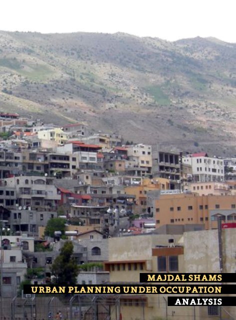
<strong>MAJDAL</strong> <strong>SHAMS</strong>
86<br />
87<br />
TOWER OF THE SUN is the English translation for the<br />
Arabic name of the Syrian Druze village Majdal Shams on the<br />
occupied Syrian Golan Heights.<br />
With its roughly 10.000 inhabitants, it is the biggest of<br />
the five Syrian villages which are still existing on the Golan.<br />
Within the Golan Druze community it also serves as their<br />
social and cultural centre. The other three Druze villages -<br />
Ein Kinya, Mas’ada and Buq’ata - are located southwards in<br />
the vicinity of 7 km.<br />
Majdal Shams is situated on the foothills of the Israeli Mount<br />
Hermon. It lies 1.130 m above sea level and can be accessed<br />
by two main roads which are leading uphill into the village’s<br />
centre with its complex and steep topography.<br />
Majdal Shams has grown up to point until it approached the<br />
border to Syria in the East. Nowadays the distance between<br />
the border fence and the closest houses of the village is less<br />
than 30 m.<br />
In the last 40 years, the former rural village which counted<br />
approximately 3.000 residents in 1967 has transformed<br />
into a high educated and well developed society with a lot of<br />
self-established cultural institutions.<br />
The people of Majdal Shams are proud of their remarkably<br />
liberal and open-minded society. In the last five years the<br />
young generation has established a small number of bars<br />
on the western entrance of the village with weekly concerts<br />
of local bands and musicians from Palestiner or abroad.
<strong>MAJDAL</strong> <strong>SHAMS</strong><br />
100
1.000 m<br />
88<br />
89<br />
<strong>MAJDAL</strong> <strong>SHAMS</strong><br />
EIN KINYA<br />
MAS‘ADA<br />
BUQ‘ATA<br />
0 5 10<br />
20 km
<strong>MAJDAL</strong> <strong>SHAMS</strong><br />
BORDER SITUATION
90<br />
91<br />
<strong>MAJDAL</strong> <strong>SHAMS</strong><br />
MILITARY ROAD<br />
200 METERS MINEFIELD<br />
DANGER<br />
MINES !<br />
UNDOF
<strong>MAJDAL</strong> <strong>SHAMS</strong><br />
BORDER SITUATION<br />
fig. 15 Israeli-Syrian border<br />
Majdal Shams, Golan Heights<br />
September 2012
92<br />
93
POINTS OF CONTACT
94<br />
95<br />
The interrelation between the Jewish population and the<br />
Golani Druze mostly occurs in the professional sector. The<br />
private life instead takes place in Majdal Shams. Of course<br />
there are some boys having their weekly ice hockey training<br />
in Jewish Kiryat Shmona, Or families doing their weekend<br />
shopping there, but the underlying tendency is rather reluctant.<br />
A few years ago it was quite common that the young people<br />
of the Druze villages once a month went to Kiryat Shmona’s<br />
or Haifa’s discos in the weekend. But since the first bars<br />
opened approximately five years ago in Majdal Shams, this<br />
trend has almost disappeared, not at least because of the<br />
regular discrimination they supposedly had to face in Israeli<br />
establishments.<br />
The Jewish society is approaching the Golani Arabs in a very<br />
colonialist way. When not meeting them on a professional<br />
basis, mostly in their own companies, the contact is more<br />
or less reduced to “touristic” means, e.g. consuming some<br />
special Arabic food or buying some homemade olives, pita<br />
and cheese.<br />
Nevertheless, we have to admit that, despite the fact that<br />
the Israelis still are very clearly seen as the occupying<br />
power, the people of Majdal Shams are no less welcoming<br />
to them than to any other person. At the beginning of our<br />
research when we were walking all day long through the<br />
streets of Majdal Shams we were often mistaken for Israelis,<br />
but everybody we met greeted us in Hebrew and was very<br />
friendly and hospitable.
POINTS OF CONTACT<br />
LIVING<br />
LIVING<br />
Europe<br />
USSR (Russia)<br />
INTERNATIONAL<br />
USA<br />
Kiryat<br />
Shmona<br />
settlement<br />
GOLAN<br />
ISRAEL<br />
Syria<br />
Haifa<br />
settlement<br />
Tel Aviv<br />
settlement<br />
Beer Sheva<br />
settlement<br />
Jerusalem<br />
Eilat<br />
Nabulus<br />
STUDYING
96<br />
97<br />
Under normal circumstances young people born<br />
in the periphery are attracted by the opportunities<br />
and the vibrant life of the big cities...<br />
... the youth of Majdal Shams does<br />
not want to live in the Israeli cities.<br />
Nor do they have the possibility<br />
to easily move to the Syrian<br />
metropolises.<br />
The great majority of<br />
the young and educated<br />
people return to Majdal<br />
Shams after they have<br />
studied in Israel or<br />
abroad.<br />
ISRAEL<br />
SYRIA
POINTS OF CONTACT<br />
STUDYING<br />
STUDYING<br />
Europe<br />
USSR (Russia)<br />
INTERNATIONAL<br />
USA<br />
Kiryat<br />
Shmona<br />
settlement<br />
GOLAN<br />
ISRAEL<br />
Syria<br />
Haifa<br />
settlement<br />
Tel Aviv<br />
settlement<br />
Beer sheva<br />
settlement<br />
Jerusalem<br />
Eilat<br />
Nabulus<br />
WORKING
98<br />
99<br />
The competition of Syria and Israel for the loyalty<br />
of the Golan Druze generated a system of scholarships<br />
and easier access to universities.<br />
As a result, a society with an<br />
unusually high percentage of<br />
academics emerged.<br />
U S S R<br />
I S R A E L<br />
$$<br />
I A<br />
S Y R<br />
easier access<br />
scholarschips
POINTS OF CONTACT<br />
WORKING<br />
WORKING<br />
Europe<br />
USSR (Russia)<br />
INTERNATIONAL<br />
USA<br />
Kiryat<br />
Shmona<br />
settlement<br />
GOLAN<br />
ISRAEL<br />
Syria<br />
Haifa<br />
settlement<br />
Tel Aviv<br />
settlement<br />
Beer sheva<br />
settlement<br />
Jerusalem<br />
Eilat<br />
Nabulus
100<br />
101<br />
In contrast to Palestinians, Druze<br />
can reach high positions in the<br />
Israeli professional sector.<br />
Despite their high education most<br />
Druze are working as labourers in<br />
Israeli construction, industrial or<br />
agricultural businesses.<br />
present<br />
past<br />
Isra eli Settle m e nt<br />
F a r m<br />
i n g<br />
Self-sufficient<br />
In d u stry<br />
S ervice S ector<br />
B u s<br />
i n e s s<br />
Tr a d e<br />
+<br />
Far ming
POINTS OF CONTACT<br />
SPARE TIME<br />
SPARE TIME<br />
Europe<br />
USSR (Russia)<br />
INTERNATIONAL<br />
USA<br />
Kiryat<br />
Shmona<br />
settlement<br />
GOLAN<br />
ISRAEL<br />
Syria<br />
Haifa<br />
settlement<br />
Tel Aviv<br />
settlement<br />
Beer Sheva<br />
settlement<br />
Jerusalem<br />
Eilat<br />
Nabulus<br />
LIVING
102<br />
103<br />
The discriminated group<br />
tries to reduce its scope of<br />
activities...<br />
... and evolve into a society as<br />
autarkic as possible.<br />
WORKING<br />
SHOPPING<br />
PROFESSIONAL LEVEL<br />
JEWISH SECTOR<strong>MAJDAL</strong> <strong>SHAMS</strong><br />
LEISURE<br />
VACATION
ISRAELI SETTLEMENT POLICY
104<br />
105<br />
Like in the West Bank and prior to 2005 also in Gaza, the<br />
Israeli settlement policy in the Golan focuses on the exploitation<br />
of natural resources and the spatial development of<br />
settlements on the one hand and spatial limitations and<br />
economic restrictions in the Arab sector on the other hand.<br />
By today approximately 37 Jewish settlements have been<br />
built on the Golan. They are home to approximately 18.000<br />
Israelis whose number has almost reached the sum of the<br />
indigenous Syrian Arabs living there. “In the occupied territories,<br />
infrastructure and housing serve two purposes: to<br />
annex more land and resources for Israel while simultaneously<br />
excluding local residents.” 15 While the Jewish presence<br />
grows, the freedom of action of the Arab society gets<br />
minimized and their economic radius set within limits.<br />
To attract Israeli citizens to the Golan Heights region, the<br />
Israeli authorities provide a variety of incentives. People<br />
establishing businesses receive special tax incentives, low<br />
rents, lax enforcement of labour and environmental laws<br />
and extra governmental support.<br />
“... THE GOLAN HEIGHTS IS ENJOYING AN<br />
UNPRECEDENTED DEVELOPMENT BOOM AND<br />
HIGHLY GENEROUS INCENTIVES ARE OFFERED<br />
TO POTENTIAL SETTLERS. JUST COME AND<br />
SETTLE HERE! WHERE ELSE IN ISRAEL CAN<br />
YOU RECEIVE THESE DAYS A PLOT OF LAND<br />
FOR FREE?” 16 - Al Monitor - The Pulse of the Middle East -<br />
- October 8, 2012 -<br />
15 Molony, Stewart, Tuohy-Hamill. “From Settlement to Shelf: The Economic<br />
Occupation of the Syrian Golan”. Al-Marsad - The Arab Centre for Human<br />
Rights in the Occupied Syrian Golan. December 2009. 57.<br />
16 Petersburg, O. “Israelis Moving to Golan Heights As Development Booms”.<br />
Al Monitor - The Pulse of the Middle East. October 8, 2012. http://www.<br />
al-monitor.com/pulse/business/2012/10/the-plot-of-land-is-for-free-tho.<br />
html
ISRAELI SETTLEMENT POLICY<br />
NEVE ATIV<br />
Israeli moshav<br />
21<br />
Golan Heights, 2 km west of Majdal Shams<br />
173 inhabitants (2005)<br />
founded 1972<br />
built in place of the destroyed Syrian village Jubata ez-Zeit<br />
main industry: tourism<br />
Neve Ativ’s administration border is almost two times bigger<br />
than the one of Majdal Shams, although their inhabitants<br />
amount to only approximately 2 % of the Arab village.<br />
The families of Neve Ativ operate the only ski resort in Israel,<br />
with up to 11.000 visitors per weekend during the winter<br />
season between December and March. The ownership of the<br />
resort is controversial because the moshav has no propriety<br />
rights in the land but undertakes major efforts to exclude<br />
anybody else from the business, especially the Arab<br />
citizens of Majdal Shams.<br />
21<br />
moshav is a type of Israeli settlement, in particular a type of cooperative<br />
agricultural community of individual farms pioneered by the<br />
Labour Zionists. It is similar to a kibbutzim but with an emphasis<br />
on community labor.<br />
administrative boundary of Majdal Shams<br />
village of Majdal Shams<br />
administrative boundary of Neve Ativ<br />
settlement of Neve Ativ<br />
Mount Hermon ski resort
106<br />
107<br />
<strong>MAJDAL</strong> <strong>SHAMS</strong><br />
Majdal Shams and Neve Ativ fig. 16<br />
Golan Heights<br />
2012<br />
0<br />
1<br />
2<br />
5 km
ISRAELI SETTLEMENT POLICY<br />
KIRYAT SHMONA<br />
Israeli city<br />
North District, 20 km west of Majdal Shams<br />
23.100 inhabitants (2007)<br />
founded 1949<br />
built in place of the former Bedouin village Al-Khalisa<br />
Kiryat Shmona is Israel’s northernmost city. It is located two<br />
kilometres east of the Israel-Lebanon border. In Israel the<br />
Jewish residents of a development area (the Occupied Palestinian<br />
Territories) or a settlement which lies close to the<br />
border or in the periphery far away from the country’s centre<br />
receive tax deductions up to 13 %. Since 2010 this law<br />
has also been applied to the Golan Heights. The indigenous<br />
Syrian population continues to have to pay full taxes. The<br />
law has the stipulation to be renewed every year. To date<br />
the law remains in force and therewith it strengthens the<br />
existence and expansion of illegal Jewish settlements and<br />
the discriminatory policies against Arabs.<br />
22<br />
22<br />
Russell, H. “Al-Marsad’s Position Paper on the Israeli Government’s<br />
Decision to Relieve Illegal Jewish Settlers in the Occupied Syrian Golan<br />
from Paying Tax”. February 15, 2010<br />
Israeli state boundary<br />
fig. 17 Kiryat Shmona<br />
North Israel<br />
2012<br />
0<br />
0,5<br />
1 2 km
<strong>MAJDAL</strong> <strong>SHAMS</strong><br />
108<br />
109<br />
0<br />
0,5<br />
Majdal Shams fig. 18<br />
Golan Heights<br />
2012<br />
1 2 km
ISRAELI SETTLEMENT POLICY<br />
QAZRIN<br />
Israeli settlement + local council<br />
North District, 30 km south of Majdal Shams<br />
6.600 inhabitants (2011)<br />
founded 1977<br />
built in place of the former Bedouin village Kisrin<br />
Qazrin is the largest Jewish settlement in the Golan Heights<br />
and is regarded as the “Capital of the Golan”. It serves as a<br />
district town that provides educational, administrative and<br />
cultural services to the surrounding region. Contrary to the<br />
regional flat roof, the Israeli settlements adapted the western<br />
style of red tiled pitched roofs. This architectural feature<br />
also serves a military purpose as it makes Jewish settlements<br />
easier identifiably from above.<br />
area covered by buildings<br />
fig. 19<br />
Qazrin<br />
Golan Heights<br />
2012<br />
0<br />
250<br />
500<br />
1.000 m
<strong>MAJDAL</strong> <strong>SHAMS</strong><br />
110<br />
111<br />
Majdal Shams fig. 20<br />
Golan Heights<br />
2012<br />
0<br />
250<br />
500<br />
1.000 m
ISRAELI LAND POLICY
112<br />
113<br />
“IF THE ISRAELIS BUILD A NEW STREET, YOU<br />
HAVE TO BE AFRAID THAT A NEW JEWISH<br />
SETTLEMENT WILL FOLLOW.”<br />
- Salman Fakhr al-Deen, Researcher at Al-Marsad -<br />
- Majdal Shams -<br />
In contrast to the Israeli settlements the spatial development<br />
of the Syrian Arab villages is restricted either direct<br />
through land confiscation or via the tool of urban planning.<br />
With the aim to restrict, Israeli authorities declare land<br />
neighbouring Arab villages as all kind of “zones” or “areas”.<br />
As an example the hillside directly declining from the official<br />
Israeli planning border in the North and West of Majdal<br />
Shams is declared as a nature reserve which means any kind<br />
of building or cultivating is strongly prohibited.<br />
“Closed military zone” is another type of area which the Israelis<br />
often use, to make the marked land unavailable for<br />
the indigenous population which owned it originally. To trespass<br />
or use this land is fined and in many cases the areas<br />
are spread with mines.<br />
Two closed military zones have also been established inside<br />
the village of Majdal Shams. One on the previously under<br />
used part of the villages graveyard is an Israeli military base<br />
to observe the Syrian border. The other one just lies vacant<br />
due to the mines which have been planted there.
fig. 21<br />
Children playing in the snow next to a minefield<br />
Majdal Shams, Golan Heights<br />
December 2011<br />
“The prevalence of Israeli mines around and throughout the<br />
occupied Syrian Golan Heights continues to be a critical concern<br />
for Golanis. [...] two mine fields are within 200 meters<br />
of primary schools in Majdal al-Shams. [...]mines not only<br />
continue to limit agricultural activities, but also surround<br />
Golani neighbourhoods and thus present an immediate risk<br />
to civilians, especially children who play in the area. [...] it<br />
was reported that a mine had exploded on 27 January 2012<br />
owing to heavy rains in the area. While private property was<br />
destroyed, Israel did not respond to a request for compensation.<br />
[...] Israel had adopted a national plan on mines. Yet,<br />
in the occupied Syrian Golan Heights [...] Israel is not demining<br />
areas near Golani neighbourhoods, but rather tourist<br />
sites visited exclusively by Israelis.”<br />
17<br />
17 “Report of the Special Commitee to Investigate Israeli Practices...”, United<br />
Nations General Assembly, 2012, 16.
114<br />
115
fig. 22 Apple orchard in autumn<br />
Majdal Shams, Golan Heights<br />
September 2012
116<br />
117<br />
“THE ISRAELI ADMINISTRATION, THEY CLAIM<br />
THAT EVEN HERE IN THE VILLAGE, SOME OF<br />
THE LAND BELONGS TO THE STATE.” 18<br />
According to Israeli authorities, all land on the Golan Heights<br />
belongs to the state of Israel, except the property which<br />
had been officially registered to private persons before the<br />
outbreak of the 1967 war.<br />
- Dr. Nazeh Brik, Architect and Urban Planner -<br />
- Majdal Shams -<br />
But the traditional land-holding system of the Syrian Arab<br />
villages meant that one half of the land was collectively<br />
owned by the villagers, while the other half was individually<br />
owned. Prior to 1967, a large portion of this individuallyowned<br />
land was not properly registered, and with the occupation<br />
the opportunity to register land ended.<br />
The collectively owned lands were sometimes rocky and<br />
poor, and therefore used for grazing rather than cultivation.<br />
Such lands were a prime target for confiscation by the Israelis<br />
who declared it as “state land”.<br />
In order to prevent the confiscation of their land the Druze<br />
villages split their collective land amongst their inhabitants<br />
and planted it with apple trees. The assumption was that<br />
the more developed the land, the more difficult it would be<br />
to confiscate. 19<br />
18 Molony, Stewart, Tuohy-Hamill. 69<br />
19 Golan for Development. “The occupied Syrian Golan”. http://www.jawlan.<br />
org/english/openions/read_article.asp?catigory=13&source=3&link=8
fig. 23 Apple orchards with water tanks<br />
Majdal Shams, Golan Heights<br />
September 2012
118<br />
119<br />
The apple and the orchards have become a symbol for the<br />
Golani Druze resistance against the Israeli occupying power.<br />
Until today every family still possesses and cultivates an<br />
apple plantation. But only the owner of more than 20 ha can<br />
make a living from it. All the other villagers have become<br />
part-time farmers and use the apples as an additional<br />
source of income or for their personal consumption.<br />
Furthermore, the fields are used for recreation. When the<br />
weather is fine the Golanis spend their leisure time in the<br />
gardens. Many of them have built sheds in which they use to<br />
play cards, make music or set up barbecues. The sheds are<br />
not only used for storing tools, they are rather serving as<br />
small summer homes. This might be a relict from former<br />
times when all villagers were farmers and used to stay on<br />
the orchards with the whole family during the harvest.<br />
Nowadays most of these tiny houses are built illegally due<br />
to the fact that Israel prohibits their establishment in the<br />
way the Arab population used to build them. Since the Israeli<br />
occupation, the indigenous people are not allowed to<br />
build in a massive construction method with stones or concrete<br />
anymore. Instead they are supposed to build in a light<br />
way with wooden material to prevent people using it for<br />
sleeping there overnight.<br />
The apple trees have saved many square meters of Golanese<br />
land from being expropriated by the Israelis. But to<br />
date land confiscations continue to take place. In the last<br />
four to five years Israel has uprooted more than 10.000 apple<br />
trees to transform into state land. When this happens<br />
the Golani Druze go to the land collectively and replant the<br />
trees as fast as possible.
<strong>URBAN</strong> <strong>PLANNING</strong><br />
“THERE ARE TWO WAYS THAT DEVELOPMENT<br />
IS RESTRICTED. THE FIRST WAY IS THAT THEY<br />
CONFISCATE LAND DIRECTLY, AND THE SEC-<br />
OND THING IS THE VILLAGE BUILDING PLAN,<br />
WHICH IS MADE BY THE AUTHORITIES [...].<br />
THE MAIN STRUGGLE BETWEEN THE ARABS<br />
AND ISRAEL IS WHO CONTROLS MORE LAND.<br />
THIS IS THE MAIN POINT. ONE OF THE ISRAELI<br />
SYSTEMS THAT THEY USE TO LIMIT ARABIC<br />
SOCIETY DEVELOPMENT [...] IS <strong>URBAN</strong> PLAN-<br />
NING. THEY USE IT AS A TOOL TO LIMIT THE<br />
ARAB SOCIETY DEVELOPMENT IN THIS CASE.”<br />
Israel as the occupying power uses urban planning as a<br />
powerful political instrument to severely curtail the residential<br />
development of the indigenous Arab civilization. The<br />
development plan for Majdal Shams which the Israeli authorities<br />
released in 1998 can be taken as a typical example for<br />
the Israeli strategy.<br />
ISRAELI SETTLEMENT
120<br />
121<br />
The old pristine houses of the village were one, maximum<br />
two stories high. They were built of stone, clay, wood and<br />
straw. Today most of the building heights range between<br />
one and four stories, but also some five and six storey<br />
houses do exist. The most used building material is concrete<br />
with a natural stone cladding. Since the occupation<br />
the village has grown rapidly without being able to widen its<br />
boundaries as it once would have been necessary.<br />
“...IF YOU COMPARE ISRAELI SETTLEMENTS<br />
WITH ARAB RESIDENTIAL PLACES IS THAT<br />
YOU SEE A BIG DIFFERENCE BETWEEN THE<br />
TWO SECTORS, BETWEEN THE ARAB SECTOR<br />
AND THE JEWISH SETTLEMENT. THEY HAVE<br />
LARGE PLACES, GREEN PLACES, BUT IN MA-<br />
JDAL <strong>SHAMS</strong> FOR EXAMPLE IT IS HIGH DEN-<br />
SITY, THE HOUSES ARE VERY CLOSE TO EACH<br />
OTHER AND THERE ARE NO PARKS OR OPEN<br />
PLACES.”<br />
To address the issue of a growing village population the<br />
Israeli plan suggests a vertical densification instead of<br />
enlarging the ground area. It earmarks six stories for the<br />
whole town of Majdal Shams except the zone directly next<br />
to the border, where buildings in close proximity to the border<br />
fence are only allowed to be built two stories high.<br />
“IN ALL THE <strong>URBAN</strong> <strong>PLANNING</strong> MADE BY THE<br />
STATE AND SOMETIMES PERMITTED BY THE<br />
STATE, I NOTICE A SPECIAL ATTENTION TO<br />
HIGH BUILDING. IN ALL THE ARAB PLACES,<br />
THERE IS A HIGH DENSITY OF PEOPLE AND<br />
INSTEAD OF ENLARGING THE SPACE OF THE<br />
VILLAGE, THEY BUILD UPWARDS. WHAT IS<br />
CALLED INTENSIVE BUILDING, HIGH DENSITY.<br />
NOW THEY ALLOW IN <strong>MAJDAL</strong> <strong>SHAMS</strong>, SIX<br />
STORIES, IN SPITE OF THE FACT THAT IT’S<br />
NOT SUITABLE FOR THE LANDSCAPE OF MA-<br />
JDAL <strong>SHAMS</strong>.”<br />
- Dr. Nazeh Brik, Architect and Urban Planner - 20<br />
- Majdal Shams -<br />
ARAB VILLAGE<br />
20 Molony, Stewart, Tuohy-Hamill. 68 - 70
DEVELOPMENT PLAN<br />
<strong>MAJDAL</strong> <strong>SHAMS</strong><br />
1998<br />
planning border<br />
boundary nature reserve<br />
residential building area A<br />
residential building area B<br />
sport<br />
public building area<br />
public green<br />
public private green<br />
commercial area<br />
cemetery<br />
drinking water pump<br />
road service<br />
existing street<br />
residential street<br />
planned street<br />
special use (military)<br />
invalid street<br />
existing buildings (1998)<br />
existing buildings (2012)
122<br />
123<br />
0 100 200<br />
500 m
<strong>URBAN</strong> <strong>PLANNING</strong><br />
THE STRUGGLE FOR LAND
124<br />
125<br />
Since the indigenous population has been expropriated of<br />
their own land, they are facing huge difficulties in purchasing<br />
new land or receiving building permits. Due to the political<br />
circumstances the people often feel like not having any<br />
other opportunity than building without permission. Illegal<br />
building is fined by the Israeli authorities with high fees for<br />
each court proceeding or even the threat of destruction.<br />
“SO YOU KNOW IF YOU WANT TO BUILD A<br />
HOUSE YOU HAVE TO GET A PERMIT FROM THE<br />
LAND AUTHORITY AND IT’S VERY, VERY DIF-<br />
FICULT. YOU HAVE TO SIGN FOR THEM THAT<br />
IT BELONGS TO ISRAEL. THEN THEY WILL<br />
GIVE YOU A PERMIT. BUT A PERMIT DOESN’T<br />
MEAN THAT IT BELONGS TO YOU, IT MEANS<br />
YOU RENT THE BUILDING LAND FROM THE IS-<br />
RAELI AUTHORITIES. AND THE PEOPLE, THEY<br />
REFUSE THAT, MOST OF THE PEOPLE, BECAUSE<br />
IT MEANS YOU KNOW, RECOGNITION, AC-<br />
CEPTING THE <strong>OCCUPATION</strong>.” 23<br />
- Dr. Nazeh Brik, Architect and Urban Planner -<br />
- Majdal Shams -<br />
Especially the young Golanis have an urgent need for available<br />
building land. In the Arab tradition a house has to be<br />
built before a marriage can take place. Traditionally the<br />
groom provides the new home and the bride brings the interior.<br />
Nowadays they often share the costs for both and if<br />
a couple cannot afford it yet, they are living in an apartment<br />
until they can cover the expenses for their own house.<br />
“IF WE WANT MORE LAND, WE MUST BUY<br />
IT OR RENT IN FROM THE ISRAELI AUTHORI-<br />
TIES. AND WE CANNOT RECOGNIZE THE IS-<br />
RAELI <strong>OCCUPATION</strong>. AND WE CANNOT BUY<br />
OR RENT LAND FROM THE ISRAELIS BECAUSE<br />
WE DON’T CONSIDER THEM THE OWNERS OF<br />
THE LAND. HOW CAN WE RENT THE LAND OR<br />
BUY IT FROM THOSE WHO DON’T OWN IT?<br />
THIS IS A MORAL AND POLITICAL ISSUE. THEY<br />
WILL NOT ALLOW US [TO BUY OR RENT THE<br />
LAND]. AND EVEN IF THEY DID ALLOW US, WE<br />
24<br />
WOULDN’T ACCEPT IT, WE WOULDN’T DO IT.”<br />
- Mufeed Al Wili, Al-Marsad affidavit -<br />
- Buq’ata -<br />
23 Molony, Stewart, Tuohy-Hamill. 69.<br />
24 Ibid. 66.
AUTONOMOUS <strong>PLANNING</strong>
126<br />
127<br />
“THE ONLY LAW IN ISRAEL WHICH IS NOT<br />
AGAINST ARABS, IS THE SEATBELT LAW.”<br />
- Lawyer from Majdal Shams -<br />
If one compares Arab and Jewish settlements in the whole<br />
country of Israel and its occupied territories, it can be assumed<br />
that Israel tries to keep the Arab villages and towns<br />
as undeveloped and dependent as possible.<br />
All infrastructure is only built for Israeli settlements and in<br />
Israeli towns. All institutions are established in Israeli surroundings,<br />
even if there exists a bigger Arab city in close<br />
vicinity. The aim is to keep the control and to invest only in<br />
the Jewish sector.<br />
Due to the fact, that the Druze people on the Golan Heights<br />
do not accept Israeli citizenship, they do not have the right<br />
to vote. Also the major of Majdal Shams is not elected by the<br />
inhabitants themselves, but deployed by the Israeli authorities<br />
and therewith lacks the full acceptance of the people.<br />
The citizens of Majdal Shams also share the conviction that<br />
the Israeli state never does any planning or investment to<br />
meet the needs of the Arab society. Against this backdrop<br />
and the fundamental lack of any kind of development...<br />
...THE GOLANI DRUZE COMMUNITY CAME TO A<br />
TRADITION OF AUTONOMOUS, DEMOCRATIC<br />
AND SELF-SUFFICIENT <strong>PLANNING</strong>.
AUTONOMOUS <strong>PLANNING</strong><br />
SEWAGE SYSTEM<br />
In early 1982 the Golani Druze went on strike after their petition<br />
for a reversal of the formal annexation of the Golan by<br />
Israel on December 14, 1981. The strike last for six months<br />
and crippled the industry in the North of Israel for several<br />
weeks.<br />
In response the Israeli army cut off the Druze villages from<br />
one another by armed soldiers, denied contact to Israel and<br />
the rest of the world, cut off electricity and water, placed<br />
some village leaders under administrative detention and<br />
destroyed several homes. However the Druze did not surrender.<br />
During this turbulent period the inhabitants of Majdal<br />
Shams did not only demonstrate several ways of nonviolent<br />
resistance, they also took advantage of having spare time<br />
at home and started to widen the streets, develop the cemetery<br />
area and completed a major sewer project on which<br />
funds and permits for installation had been refused by the<br />
Israeli authorities for years.
efusal of work<br />
nonviolent<br />
resistance<br />
demonstrations ...<br />
money<br />
manpower<br />
1981 annexation of the Golan Heights<br />
1982 strike<br />
sewage system project<br />
completion of a<br />
cut-down version<br />
at night<br />
attempts to force<br />
Israeli<br />
citizenship<br />
building freeze<br />
declaration as illegal<br />
sealing off<br />
denial of contact<br />
cut off<br />
destruction<br />
128<br />
129<br />
to Israel<br />
+ world<br />
electricity<br />
water<br />
administrative detention<br />
of houses<br />
legalization<br />
maintenance with<br />
public funds<br />
“It was winter time and the lack of a sewage system meant<br />
the village was very dirty. We established a committee to<br />
discuss the issue and we decided to construct a sewage<br />
system in the village. We did a general study to evaluate the<br />
project and we found that to make this project work ever<br />
house had to pay $200 and contribute four work days to<br />
the project. If people cannot work they could contribute $50<br />
instead of the four days. On many occasions people ended<br />
up working more time than was required of them and many<br />
of the big machines, the tractors and so on worked for free.<br />
Also there were a lot of cases where people couldn’t pay the<br />
money so they worked instead. Before the end of the strike<br />
the project was completed with the money that we had. [...]<br />
a lot of the poorer families who couldn’t pay had promised<br />
to pay in the future but it was decided by the committee<br />
to forget the issue because the project was completed.” 25<br />
- Jameel Awad, Al-Marsad Affidavit -<br />
- Majdal Shams -<br />
Shortly after the villagers had started their construction<br />
work for the sewage system, the Israeli army officer in<br />
charge declared their work as illegal and forced them to<br />
stop. Thereupon the work was done at night in a cut-down<br />
version. Until nowadays the village uses this very sewage<br />
system but after Israeli legalization it has been maintained<br />
by the municipality with public Israeli funds.<br />
25 Molony, Stewart, Tuohy-Hamill. 30, 31.
AUTONOMOUS <strong>PLANNING</strong><br />
MEDICAL CENTER<br />
When Israel annexed the Golan Heights in 1981, the Arab<br />
population of the Golan realized that they had to face a long<br />
term occupation. Coming to this conclusion, some Golanis<br />
started to change their strategy of demonstrating only to a<br />
more active way of resistance by finding methods to develope<br />
their own society.<br />
The GfD conducted a comprehensive survey to detect the<br />
most pressing needs of the Druze population. Very poor<br />
health conditions such as in Majdal Shams where one physician<br />
served 8.000 people, provoked the organisation to<br />
establish a 24 hour health clinic as their first social improvement.<br />
In 1991 the local non-profit organization Golan for Development<br />
of the Arab Villages (GfD) was founded in Majdal<br />
Shams. The aim of the organization is to establish a „selfreliant<br />
and democratic modern society in the Golan as a way<br />
of resisting the occupational policy“. That means providing<br />
alternative services to the Arab population than those offered<br />
by the Israeli authority. To become more independent<br />
from the occupational power it was very important to establish<br />
a self organized platform which enabled the development<br />
of plans and strategies to satisfy the needs of the<br />
population.<br />
In the first phase of finding an appropriate place for realizing<br />
this ambitious goal, the NGO was already hindered by the Israeli<br />
authority. After various harassments towards private<br />
individuals of the organisation and those citizens who were<br />
willing to support them, GfD found a family-less ex-prisoner<br />
upon whom Israel could not impose enough pressure, to<br />
rent a room for the clinic on his private property.<br />
With donations and voluntary labour by the locals, and financial<br />
support by foreign organisations, the 24 hour clinic<br />
was established in 1993. To create a continuous cash flow, a<br />
private health insurance was founded in which every member<br />
had to pay $15 per month to receive full medical care<br />
in return.<br />
As Israel realized that the clinic proved to be successful<br />
they changed their repressive tactic and established instead<br />
a government clinic in 1996 to surpass the Arab one<br />
and poach patients away. The benefit for the population<br />
was great, going from almost no medical supply to two clinics<br />
in a very short time.
130<br />
131<br />
Initiator: Golan for Development (NGO)<br />
health<br />
insurance<br />
15$/month/person<br />
donations<br />
location<br />
donations<br />
voluntary labour<br />
survey<br />
poor health conditions<br />
1993 24h clinic established<br />
Integration<br />
1997<br />
High Standard Medical Supply<br />
+<br />
powerful voice in negotiating<br />
with the Israeli health insurance<br />
companies<br />
personal threatening of activists + supporters<br />
governmental<br />
24h clinic<br />
established<br />
1995 National Health Insurance Law<br />
2006<br />
governmental 24h clinic<br />
closed<br />
1996<br />
The Israeli attempt to regain the control over the medical<br />
infrastructure failed and due to the inability to compete<br />
with the loyalty of the Druze patients and the economic advantage<br />
of their voluntary work in their own medical centre,<br />
prompting the governmental clinic to close ten years later<br />
in 2006.<br />
Presently the management of the Medical Center holds a<br />
powerful voice in negotiating with the insurance companies<br />
as they act as a mediator between them and the Druze population<br />
of approximately 20.000 people. Today many medics<br />
from the Golan are working all over Israel and therewith a<br />
lively exchange on professional level has begun.<br />
After the Knesset passed the „Israeli National Health Insurance<br />
Law“ in 1995, two years later also the Druze had<br />
to join the mandatory Israeli health insurance and the 24<br />
hour clinic got integrated in the national health system<br />
and started to cooperate with Israeli insurance companies.<br />
Besides the Medical Center with around 80 employees in<br />
all four Druze villages, the GfD has also founded several<br />
institutions such as a kindergarten, a theatre and a music<br />
school. The organisation also organizes activities for women<br />
and offers agricultural outreach services for farmers.
1311<br />
AUTONOMOUS <strong>PLANNING</strong><br />
BUILDING ON THE WAQF<br />
1425<br />
797<br />
400<br />
1372<br />
1380<br />
1367<br />
797<br />
650<br />
1330<br />
1357<br />
1322<br />
1311<br />
According to Nazeh Brik the Israeli development plan for<br />
Majdal Shams does not consider the real Arab ownership<br />
structure of the land in any way. Areas marked as public<br />
green are private property and planned streets are cutting<br />
through private plots. When the plan was published 850 inhabitants<br />
of Majdal Shams filed a complaint. The young generation<br />
in particular criticized the fact that no new building<br />
areas were declared.<br />
To address this issue, the civil community of Majdal Shams<br />
gathered in a plenary meeting in 2009. The assembly decision<br />
was to reclaim approximately 3.000 dunums 26 of land<br />
from the mountainside in the North of the village. The land<br />
had been used as waqf 27 before the Israelis expropriated it<br />
and declared it to be a nature reserve.<br />
797<br />
900<br />
1410<br />
1440<br />
1394<br />
1405<br />
1385<br />
Five representatives of the religious community and five of<br />
the secular population got elected and they commissioned<br />
local experts to work out an alternative development plan<br />
for the reclaimed area. All people involved in the planning<br />
process worked voluntarily or for a minimum salary to support<br />
the community’s aim.<br />
1352<br />
1313<br />
1342<br />
1333<br />
1326<br />
1312<br />
1346<br />
1339<br />
1337<br />
1334<br />
During the planning process several feedback meetings<br />
were held to inform the population and at the end, approximately<br />
1.200 new parcels were distributed among<br />
1317<br />
1330<br />
26 1 dunam = 1.000 sqm<br />
27 waqf = community land
132<br />
133<br />
voluntary<br />
labour<br />
850 private complaints<br />
population growth<br />
new building land<br />
needed<br />
2002 plenary meeting<br />
alternative masterplan<br />
development<br />
plan<br />
6 storeys + no new building land<br />
1998<br />
$3.000 $500 advanced payment<br />
1 new building plot / family<br />
voluntary labour<br />
2011 1 st construction phase building freeze temporary arrests +<br />
interrogations + personal threatening<br />
negotiations<br />
legalization<br />
public funds for infrastructure<br />
the young generation. Each family received one plot for<br />
a symbolic prize of $3.000 with an advanced payment of<br />
$500 to finance the utilization of the site by levelling the<br />
prospective roads.<br />
A camp was established on site to ensure the continuous<br />
presence of villagers and after two month of preparative<br />
road construction in 2011, Israel interfered and stopped<br />
the work in its first phase. The responsible persons were<br />
temporarily arrested and interrogated.<br />
Israel acted as foreseen and according to the people of<br />
Majdal Shams an important goal is reached: with the road<br />
levelling facts are accomplished and Israel has been forced<br />
to join negotiations about the shortage of building land. If<br />
Israel should accept the alternative development plan designed<br />
by the civil society of Majdal Shams and would legalize<br />
it, the state would have to co-finance the set up of<br />
the infrastructure which will be very expensive due to the<br />
topography with up to 70% slope.<br />
Both the public funds and Israel’s approach to physically<br />
interfere had been foreseen in the planning since the beginning<br />
because otherwise neither the negotiations about the<br />
land issue would ever happen nor could the project be fully<br />
financed by the private people of Majdal Shams themselves.
ALTERNATIVE DEVELOPMENT PLAN<br />
<strong>MAJDAL</strong> <strong>SHAMS</strong><br />
planning border official plan<br />
boundary nature reserve<br />
private parcel<br />
public building area<br />
public green<br />
street<br />
residential street<br />
crossroad<br />
existing buildings (2012)
42<br />
3 3<br />
15<br />
213<br />
2 2<br />
6<br />
134<br />
135<br />
0 100 200<br />
500 m
ECONOMIC <strong>OCCUPATION</strong><br />
fig. 24<br />
Market seller and his stand<br />
close to Mas’ada, Golan Heights<br />
September 2012
136<br />
137<br />
“... THEY [THE ISRAELIS] CONTROL THE SKY<br />
AND THE LAND, BUT OUR LANDS ARE STILL<br />
OURS. THEY DID TRY ON DIFFERENT OCCA-<br />
SIONS TO CONFISCATE OUR LAND BUT THEY<br />
FAILED. SO THEY HAVE BEGUN COMPETING<br />
WITH US BY GROWING THE SAME PRODUCTS<br />
AS US.” 28 - Hayil and Samar Abu Jabal, Al-Marsad affidavit -<br />
- Majdal Shams -<br />
The construction of Israeli settlements in the occupied<br />
territories is widely viewed as the main stumbling block to<br />
peace in the region. As long as the settlements continue to<br />
be built and Israel establishes further facts on the ground,<br />
the economic exploitation of natural resources and discriminatory<br />
policies continue to affect the economic wellbeing of<br />
the indigenous Arab population.<br />
The Israeli companies in the Golan range from small businesses<br />
which serve the settlements, to large factories<br />
which export their products to the global market, in particular<br />
to Europe and the United States. Since the occupation<br />
began, Israel has instituted many policies to exclude<br />
the indigenous population from many of their local private<br />
economies such as livestock rearing. At the same time, Israel<br />
monopolises control over the natural resources of the<br />
region. As in the occupied Palestinian Territories, this has<br />
resulted in the exploitation of the local population, who<br />
often have no choice but to engage in the construction of<br />
settlements or work on settlement farms due to a lack of<br />
alternative employment. The thriving economy of the Israeli<br />
settlements is made possible by policies and practices<br />
which remove competition with the local Arab farmers and<br />
distribute vital resources in an inequitable manner, stunting<br />
the growth of the local Arab economy.<br />
28 Molony, Stewart, Tuohy-Hamill. 50.
Prior to the 1967 war, the inhabitants of the Golan had an<br />
economy based primarily on agriculture and livestock, with<br />
62% of the workforce engaged in this sector. The industrial<br />
sector was less developed, accounting for 20% of workers.<br />
fig. 25<br />
Apple Crossing<br />
Al Qunaitra Checkpoint<br />
March 2, 2010<br />
Many of the Arab residents in the Golan lost up to half their<br />
29<br />
agricultural land following the occupation. As a result of<br />
land expropriation, the production of field crops and dairy<br />
products was irrevocably damaged and disappeared completely.<br />
The Arab population of the Golan was then forced to<br />
depend on Israeli agricultural products and settlement<br />
products, in particular dairy products.<br />
30<br />
29 “The occupied Syrian Golan: Background” Al-Marsad - The Arab Center for<br />
Human Rights in the Occupied Syrian Golan. 2005. 13.<br />
30 Ibid. 14.
138<br />
139<br />
“AT THE BEGINNING OF THE <strong>OCCUPATION</strong>,<br />
IN BUQ’ATA, THERE WERE FOUR THOUSAND<br />
GOATS AND SHEEP. NOW, 42 YEARS LATER<br />
[2009], THERE ARE THREE HUNDRED HEADS...<br />
IN A BIGGER SOCIETY, WE HAVE LESS. IT<br />
MAKES THE GOLAN CONNECTED, IN THE ISSUE<br />
OF MILS AND MEAT, TO THE ISRAELI MARKET.<br />
THE MAIN REASON FOR THIS [DECREASE IN<br />
GRAZING] IS THE CONFISCATION OF LAND<br />
AROUND THE VILLAGE OF BUQ’ATA FOR THE<br />
SETTLERS, AND THE BORDER, THE CEASEFIRE<br />
LINE ALSO, AND THE MINES. BUQ’ATA IS SUR-<br />
ROUNDED BY MINES AT THREE SIDES. ONE OF<br />
THE GRAZING AREAS WAS USED FOR THIS<br />
PURPOSE. THE REST WAS TAKEN TO BE USED<br />
FOR THE SETTLERS’ AGRICULTURE.<br />
THE PLACES WE USED TO GRAZE OUR FLOCKS<br />
BECAME AGRICULTURAL FIELDS FOR THE SET-<br />
TLERS. WHAT WE HAVE LEFT IS ONLY THE<br />
FOREST OF MAS’ADA... THE NATURE RESER-<br />
VATION AUTHORITY IN ISRAEL DECLARED<br />
THAT THE PRESENCE OF THE SHEEP AND<br />
GOATS IN THE FOREST IS HARMFUL.<br />
THEY TRIED TO STOP THIS ECONOMIC ACTIV-<br />
ITY IN DIFFERENT WAYS... BY CONFISCATING<br />
THE FLOCKS AND SELLING THEM FOR THE<br />
BENEFIT OF THE STATE OF ISRAEL. THEY DID<br />
THIS THREE TIMES. THEY BROUGHT TRUCKS<br />
AND THE ARMY AND THEY CONFISCATED THE<br />
FLOCKS. THEY TOOK THEM. [...]<br />
ALSO, IN MANY CASES THE PEOPLE HAD<br />
TO PAY TAXES OR PUNISHMENTS [FINES]<br />
BECAUSE IT COSTS THE STATE MONEY TO<br />
BRING TRUCKS, TO BRING ARMY, TO BRING<br />
LABOUR... YOU HAVE TO FINANCE YOUR CON-<br />
FISCATION.” 31 - Mufeed Al Wili, Al-Marsad affidavit -<br />
- Buq’ata -<br />
31 Molony, Stewart, Tuohy-Hamill. 62, 63.
“ONE DUNUM OF APPLES, TO YIELD A GOOD<br />
PRODUCT, IT NEEDS 700 - 800 M 3 [OF WA-<br />
TER] PER YEAR. WHAT THEY [THE WATER<br />
COMPANY] OFFERS US, IS 300 M 3 ... ALSO,<br />
THE PRICE OF THE WATER, WE PAY BETWEEN<br />
3,80 AND 4,00 NIS PER CUBIC METRE, THE<br />
32, 33<br />
SETTLERS PAY 1,80 TO 1,90 NIS.”<br />
- Mufeed Al Wili, Al-Marsad affidavit -<br />
Due to the facts that the Druze villagers were curtailed in<br />
their economy of livestock rearing and that they had planted<br />
almost all their land with apple trees to prevent an Israeli<br />
confiscation, their agricultural activities came to be<br />
based almost exclusively on apples.<br />
Another important issue which limited the local Arab farm-<br />
fig. 26<br />
Apple stand<br />
- Buq’ata -<br />
ers in the Golan in the type of crops they could grow, were<br />
Majdal Shams, Golan Heights<br />
the Israeli imposed water restrictions. Those restrictions<br />
September 2012<br />
are still in force.<br />
32 1 EUR = 4,78 NIS (New Israeli Shekel; March 19, 2013)<br />
33 Ibid. 73.
140<br />
141<br />
In light of the scarcity of water resources in the Middle East,<br />
the Golan is of extreme strategic importance. Shortly after<br />
the occupation began, the Israeli authorities implemented<br />
numerous policies to control the water resources of the region.<br />
Those policies severely affected the supply of water to the<br />
indigenous Syrian population and on the same time led to<br />
great benefits for the Israeli settlers. The native Syrian inhabitants<br />
were forbidden from accessing or utilising the<br />
water for agricultural purposes. In contrast, unlimited<br />
amounts of water were provided to the settlements at a<br />
low cost.<br />
All water resources in the region are considered to be the<br />
property of the Israeli state. The water of Lake Ram for example,<br />
which has always been the main source for irrigation<br />
in the Northern Golan, is piped to Jewish settlements 70 km<br />
34<br />
away, while the Arab locals in direct vicinity have only limited<br />
access.<br />
34 Golan for Development, “The occupied Syrian Golan”
fig. 27 Easten part of Majdal Shams with the Israeli military post<br />
Majdal Shams, Golan Heights<br />
September 2012
142<br />
143<br />
The local population undertook economic projects to ensure<br />
their access to water in spite of the occupation. They<br />
changed their traditional irrigation system to a new modern<br />
one in 1974 and erected approximately 650 iron tanks in<br />
their apple orchards to store water, collect rainwater and to<br />
fill the tanks with snow in winter. The Israeli authorities opposed<br />
heavy fines on the farmers and destroyed several<br />
tanks. Israel claims that all water resources - even rainwater<br />
belongs to the state.<br />
“IN THE 1980S... PEOPLE STARTED TO BUILD<br />
METAL WATER COLLECTORS FOR ABOUT 700-<br />
800 M 3 PER YEAR... IT WAS VERY EXPEN-<br />
SIVE. THE PEOPLE HAD TROUBLE WITH THE<br />
AUTHORITIES HERE, THE ISRAELI AUTHORI-<br />
TIES. THEY WANTED A LICENCE TO BUILD<br />
THESE TANKS. FOR THEM [THE AUTHORI-<br />
TIES], IT WAS IMPORTANT TO HAVE A COUN-<br />
TER ON EVERY TANK, TO COUNT HOW MUCH<br />
WATER YOU ARE USING AND TO PAY TO THE<br />
AUTHORITIES FOR THE WATER COLLECTED.<br />
SO IT WAS A LONG CONFLICT BETWEEN THE<br />
AUTHORITIES AND THE PEOPLE HERE, AND<br />
AT THE END, THEY REACHED A COMPROMISE.<br />
NO COUNTERS, NO METERS TO COUNT THE<br />
WATER THAT YOU ARE COLLECTING FROM<br />
THE RAIN, BUT THE PEOPLE HAD TO HAVE A<br />
LICENCE FOR THE TANKS.” 35<br />
- Shhady Nasralla, Al-Marsad affidavit -<br />
- Majdal Shams -<br />
35 Molony, Stewart, Tuohy-Hamill. 79.
THE VALLEY OF TEARS<br />
UNDOF OBSERVATION POST<br />
200 METERS MINEFIELD<br />
BORDER FENCE<br />
SHOUTING HILL<br />
VALLEY OF TEARS<br />
fig. 28<br />
View from Majdal Shams to Syria<br />
Majdal Shams, Golan Heights<br />
September 2012
ISRAELI MILITARY BASE<br />
144<br />
145
fig. 29 Woman, megaphone & binoculars<br />
Majdal Shams - Valley of Tears, Golan Heights<br />
Mother’s Day, March 21, 2010
146<br />
147<br />
When the border was drawn in 1967 and the Israeli authorities<br />
segregated the Golan from Syria many people found<br />
themselves separated from their families and their homes<br />
either in Syria or on the Golan Heights. All means of communication<br />
between those remaining in the Occupied Golan and<br />
those on Syrian proper were broken down and prohibited.<br />
After some time the Syrian people were given the opportunity<br />
to apply for family reunification. For those applications<br />
that were successful family members either returned to the<br />
Occupied Golan or had members of their family join them in<br />
Syria. For those moving from Syria to the Golan Heights it<br />
was under condition that it was a “one way ticket”. In recent<br />
years family reunifications have been stalled for all Arabs<br />
in Israel and the Occupied Territories, including the Golan.<br />
To ease the pain of being separated from the loved ones and<br />
to send a political sign to the governments of Syria and Israel<br />
some Druze on the Syrian side of the border built themselves<br />
a second home within eyeshot from Majdal Shams.<br />
Those houses are frequently used as weekend or holiday<br />
residences.<br />
In Majdal Shams there are several plots of land lying fallow<br />
which are belonging to those people living in Syria. Their<br />
relatives are taking care of the land and it is out of question<br />
that another villager claims the land - despite the urgent<br />
need for land to build on.<br />
Due to the fact that Israel and Syria are still in an official<br />
state of war, there is no mail service between the two<br />
states. The only possibility to transfer official papers such<br />
as birth, death and marriage certificates or property documents<br />
is via the ICRC - International Committee of the Red<br />
Cross. They also provide personal mail exchange through<br />
the Red Cross Messages.
fig. 30 Women using contruction tools<br />
Majdal Shams - Valley of Tears, Golan Heights<br />
Mother’s Day, March 21, 2010
148<br />
149<br />
In 1974, following the 1973 Arab-Israeli War, a disengagement<br />
agreement was made between Syria and Israel in<br />
which a DMZ (Demilitarized Zone) was set up between the<br />
two states and family members from both sides were able<br />
to meet at the ceasefire line fence.<br />
“WE WERE ABLE TO TOUCH AND TALK TO<br />
EACH OTHER. THIS CONTINUED UNTIL THE IS-<br />
RAELI ARMY KIDNAPPED ONE PERSON.” 36<br />
- Kamal Maziad Abu Saleh, Al-Marsad affidavit -<br />
- Majdal Shams - family separation 53<br />
Following this incident an area of 200 meters was marked<br />
out by Israel with the use of fencing and landmines on Syrian<br />
side. This area has become known as the Valley of Tears. The<br />
families from both sides met there and communicated over<br />
the distance with the aid of megaphones and binoculars. On<br />
the Syrian side a platform, the so called Shouting Hill, was<br />
established and the people on the Golanese side used to<br />
stand in the eastern elevated part of Majdal Shams close to<br />
the border fence. Villagers of Majdal Shams reported that it<br />
happened that Israeli soldiers turned on sirens to disturb<br />
the conversations between the families and drove along the<br />
middle of the Valley of Tears using their vehicles to create<br />
dust to reduce the visibility.<br />
With the advent of modern communication systems such as<br />
telephone and home access to the internet, people these<br />
days are able to communicate in a more comfortable way.<br />
But the meetings at the Valley of Tears have been a long<br />
standing tradition and also if the regularity of such meetings<br />
have decreased, they still continue on special occasions<br />
and where families are required to arrange marriages<br />
and funerals.<br />
36 Russel, H. ”Breaking Down the Fence...” 53.
05 <strong>MAJDAL</strong> <strong>SHAMS</strong><br />
150<br />
151<br />
Majdal Shams 2012<br />
Historical Development 1968-2012<br />
Population<br />
Family-Clans<br />
Urban Analysis<br />
Green + Topography<br />
Building Utilization<br />
Building Heights<br />
Road Network<br />
Building Activity<br />
Public Buildings<br />
Village Centres<br />
Walking Plan<br />
Open Space<br />
Spacial Limitations
<strong>MAJDAL</strong> <strong>SHAMS</strong> 2012<br />
“... FOR EXAMPLE IF YOU TAKE <strong>MAJDAL</strong><br />
<strong>SHAMS</strong>, FROM THE EAST SIDE, THE HOUSES<br />
THEY ARE CLOSE TO THE BORDER [...]. AND<br />
FROM THE WEST, YOU HAVE THE MAIN<br />
STREET TO THE HERMON, WHICH IS A MILI-<br />
TARY STREET. SO WE ARE CLOSED FROM<br />
ALL SIDES. FROM THE NORTH YOU SEE THE<br />
HERMON MOUNTAIN AND THE HARD TOPOG-<br />
RAPHY. IN THE BEGINNING, THE DISTRIBU-<br />
TION WAS FROM INSIDE TO OUTSIDE. BUT<br />
WE REACH A POINT WHERE WE HAVE TO GO<br />
BACK INSIDE. TWENTY YEARS BEFORE, WE<br />
HAD PUBLIC SPACES INSIDE, BUT BECAUSE WE<br />
DON’T HAVE PLACES TO BUILD THEY HAD TO<br />
USE THESE PUBLIC PLACES FOR RESIDENTIAL<br />
BUILDING. AND THIS PROCESS YOU CAN SEE<br />
IN ALL THE ARAB RESIDENTIAL AREAS, EVEN<br />
INSIDE ISRAEL, THE SAME PROCESS.” 37<br />
- Dr. Nazeh Brik, Architect and Urban Planner -<br />
- Majdal Shams -<br />
37 Molony, Stewart, Tuohy-Hamill. “From Settlement to Shelf: The Economic<br />
Occupation of the Syrian Golan”. Al-Marsad - The Arab Centre for Human<br />
Rights in the Occupied Syrian Golan. December 2009. 68.
152<br />
153<br />
0 100<br />
500<br />
Majdal Shams fig. 31<br />
Golan Heights<br />
2012<br />
1.000 m
<strong>MAJDAL</strong> <strong>SHAMS</strong> 2012<br />
fig. 32 Majdal Shams viewed from south<br />
Golan Heights<br />
September 2012
154<br />
155
POPULATION<br />
AGED 0-19 YEARS<br />
APPROXIMATELY 38% OF THE PEOPLE<br />
LIVING IN <strong>MAJDAL</strong> <strong>SHAMS</strong> ARE YOUNG-<br />
ER THAN 19 YEARS. (2008) 38<br />
>> KINDERGARTEN >> HOME<br />
CHILDREN<br />
Children are barely seen outdoors in Majdal Shams. Besides<br />
those in the kindergarten, there are no playgrounds existing<br />
in the village. Due to the high traffic and the minefields<br />
most parents are afraid of allowing their children to play<br />
outside unattended.<br />
>> HOME >> BARS + CAFÉS<br />
>> APPLE FIELDS >> CARS<br />
>> REHEARSAL ROOM<br />
YOUNG PEOPLE<br />
The young people in Majdal Shams often meet with their<br />
friends at home. Since the first bars and cafés opened<br />
around 2008 they are also frequented every day, mostly in<br />
the evening. A lot of the youth play an instrument and some<br />
even founded bands with whom they are practicing in a rehearsal<br />
room in the industrial zone or at home. It is visibly<br />
apparent that many young people own a motor vehicle like<br />
cars, motorcycles or quads, which they use to drive through<br />
the village. The absence of those in the age for studying is<br />
noticeable.<br />
38 CBS - Central Bureau of Statistics. “Population and households in localities<br />
with 5.000 residents and over”. Population Census 2008”. Table 1.21.
156<br />
157<br />
Little child sitting on a balcony<br />
fig.<br />
Majdal Shams, Golan Heights<br />
September 2012<br />
Young people having dinner at home fig. 34<br />
Majdal Shams, Golan Heights
POPULATION<br />
AGED 20-64 YEARS<br />
APPROXIMATELY 55% OF THE PEOPLE<br />
LIVING IN <strong>MAJDAL</strong> <strong>SHAMS</strong> ARE BE-<br />
TWEEN 20 AND 64 YEARS OLD. (2008) 39<br />
>> HOME >> APPLE FIELDS<br />
>> STREET >> BARS + CAFÉS<br />
>> COMMUNITY CENTRE >> SHOPS<br />
>> RELIGIOUS CENTRE >> “MEN’S CLUBS”<br />
MEN<br />
The men meet mostly without women. They come together<br />
to play cards in the garden sheds or to discuss in the cafés<br />
and bars. One man who lives close to the main square established<br />
a small meeting room in the ground floor of his<br />
house where men use to sit, smoke and drink coffee.<br />
>> HOME >> STREET<br />
>> NEIGHBOURHOOD >> FITNESS CLUB<br />
WOMEN<br />
The women mostly visit each other at home. They usually<br />
drink mate tea and discuss the news, some even started<br />
to learn English together. Many women are housewives who<br />
are taking care of the family and work only in the apple<br />
fields in the season. If the women have a regular employment,<br />
they are mostly working in Majdal Shams. For shopping<br />
many drive once a week to Jewish Kiryat Shmona.<br />
39 Ibid.
158<br />
159<br />
Men playing cards in a garden shed fig. 35<br />
Majdal Shams, Golan Heights<br />
September 2012<br />
Woman preparing mate tea fig. 36<br />
Golan Heights
POPULATION<br />
AGED 65 + YEARS<br />
APPROXIMATELY 7% OF THE PEOPLE<br />
LIVING IN <strong>MAJDAL</strong> <strong>SHAMS</strong> ARE OLDER<br />
THAN 65 YEARS. (2008) 40<br />
>> HOME >> GARDEN<br />
>> NEIGHBOURHOOD<br />
ELDERLY WOMEN<br />
The elderly women of Majdal Shams mostly stay at home or<br />
visit with their neighbours. Many women meet regularly to<br />
bake the traditional bread in groups of two or three. The<br />
tradition of family members building next to each other<br />
leads to the fact that elderly are never living alone. Due to<br />
the steep topography, the chaotic traffic situation and the<br />
lack of public transport, elderly woman are restricted in<br />
their mobility and depend on their descendants.<br />
>> HOME >> STREET<br />
>> COMMUNITY CENTRE >> SHOPS<br />
>> RELIGIOUS CENTRE >> “MEN’S CLUBS”<br />
ELDERLY MEN<br />
The elderly men of Majdal Shams can often be seen sitting in<br />
front of shops or their homes on plastic chairs, talking and<br />
drinking tea or coffee. Many of them are religious and thus<br />
spent their time in the religious centre or the community<br />
centre. Most of them barely ever leave Majdal Shams. As almost<br />
all of them used to be farmers they are often the ones<br />
taking care of the apple orchards<br />
40 Ibid.
160<br />
161<br />
Women baking bread fig. 37<br />
Majdal Shams, Golan Heights<br />
September 2012<br />
Men talking on the street fig. 38<br />
Majdal Shams, Golan Heights<br />
September 2012
FAMILY-CLANS<br />
fig. 39<br />
Piled-up homes<br />
Majdal Shams, Golan Heights<br />
September 2012
162<br />
163<br />
„I WANT TO HEAR MY GRANDSON WALKING<br />
OVER.“<br />
- saying in Majdal Shams -<br />
The four biggest families which are represented today in<br />
Majdal Shams and their estimated number of members.<br />
ABU SALEH 3.000<br />
IBRAHIM 2.000<br />
SAFADI 2.500<br />
MAHMOUD 2.000<br />
In former times each family dominated a neighbourhood in<br />
the village. Due to the spatial limitations Majdal Shams has<br />
faced in terms of growth, today the families are mixed in<br />
the urban pattern.<br />
The tradition to either build a house next to one’s parents<br />
on the family’s land or to add another floor on top of the<br />
parents house is still common. The undeveloped plots<br />
around a family’s home are always reserved for the sons<br />
and grandsons to build their house there. If a daughter gets<br />
married, she always moves to her husband’s house next to<br />
his parents.
FAMILY-CLANS<br />
GRANDSON 03<br />
GRANDSON 01<br />
GRANDSON 02<br />
SON 01<br />
SON 02<br />
SON 03<br />
DAUGHTER
Bruder Brik<br />
164<br />
165<br />
Safadi<br />
Brik<br />
Ibrahim<br />
Shams<br />
Abu Saleh<br />
Abu Jabal<br />
Mahmud<br />
0 100 200<br />
500 m
HISTORICAL DEVELOPMENT<br />
1968 - 2012<br />
1968<br />
1971<br />
1976<br />
1983<br />
1989<br />
1998<br />
2012
166<br />
167<br />
0 100 200<br />
500 m
HISTORICAL DEVELOPMENT<br />
1968<br />
ca. 3.000 INHABITANTS<br />
HIGH SCHOOL<br />
ELEMENTARY SCHOOL<br />
KINDERGARTEN<br />
MEDICAL CENTRE<br />
COMMUNITY CENTRE (RELIGIOUS)<br />
RELIGIOUS CENTRE<br />
MUSEUM<br />
THEATRE<br />
$<br />
MUSIC SCHOOL<br />
ART CENTRE<br />
INDUSTRIAL ZONE<br />
BANK<br />
HOTEL<br />
RESTAURANT<br />
CAFÉ + BAR<br />
SHOP<br />
1968<br />
1971<br />
1976<br />
1983<br />
1989<br />
1998<br />
2012
168<br />
169<br />
0 100 200<br />
500 m
HISTORICAL DEVELOPMENT<br />
1971<br />
HIGH SCHOOL<br />
ELEMENTARY SCHOOL<br />
KINDERGARTEN<br />
MEDICAL CENTRE<br />
COMMUNITY CENTRE (RELIGIOUS)<br />
RELIGIOUS CENTRE<br />
MUSEUM<br />
THEATRE<br />
$<br />
MUSIC SCHOOL<br />
ART CENTre<br />
INDUSTRIAL ZONE<br />
BANK<br />
HOTEL<br />
RESTAURANT<br />
CAFÉ + BAR<br />
SHOP<br />
1968<br />
1971<br />
1976<br />
1983<br />
1989<br />
1998<br />
2012
170<br />
171<br />
0 100 200<br />
500 m
HISTORICAL DEVELOPMENT<br />
1976<br />
HIGH SCHOOL<br />
ELEMENTARY SCHOOL<br />
KINDERGARTEN<br />
MEDICAL CENTRE<br />
COMMUNITY CENTRE (RELIGIOUS)<br />
RELIGIOUS CENTRE<br />
MUSEUM<br />
THEATRE<br />
$<br />
MUSIC SCHOOL<br />
ART CENTRE<br />
INDUSTRIAL ZONE<br />
BANK<br />
HOTEL<br />
RESTAURANT<br />
CAFÉ + BAR<br />
SHOP<br />
1968<br />
1971<br />
1976<br />
1983<br />
1989<br />
1998<br />
2012
172<br />
173<br />
0 100 200<br />
500 m
HISTORICAL DEVELOPMENT<br />
1983<br />
ca. 5.200 INHABITANTS<br />
HIGH SCHOOL<br />
ELEMENTARY SCHOOL<br />
KINDERGARTEN<br />
MEDICAL CENTRE<br />
COMMUNITY CENTRE (RELIGIOUS)<br />
RELIGIOUS CENTRE<br />
MUSEUM<br />
THEATRE<br />
$<br />
MUSIC SCHOOL<br />
ART CENTRE<br />
INDUSTRIAL ZONE<br />
BANK<br />
HOTEL<br />
RESTAURANT<br />
CAFÉ + BAR<br />
SHOP<br />
1968<br />
1971<br />
1976<br />
1983<br />
1989<br />
1998<br />
2012
174<br />
175<br />
0 100 200<br />
500 m
HISTORICAL DEVELOPMENT<br />
1989<br />
HIGH SCHOOL<br />
ELEMENTARY SCHOOL<br />
KINDERGARTEN<br />
MEDICAL CENTRE<br />
COMMUNITY CENTRE (RELIGIOUS)<br />
RELIGIOUS CENTRE<br />
MUSEUM<br />
THEATRE<br />
$<br />
MUSIC SCHOOL<br />
ART CENTRE<br />
INDUSTRIAL ZONE<br />
BANK<br />
HOTEL<br />
RESTAURANT<br />
CAFÉ + BAR<br />
SHOP<br />
1968<br />
1971<br />
1976<br />
1983<br />
1989<br />
1998<br />
2012
176<br />
177<br />
0 100 200<br />
500 m
HISTORICAL DEVELOPMENT<br />
1998<br />
ca. 8.000 INHABITANTS<br />
HIGH SCHOOL<br />
ELEMENTARY SCHOOL<br />
KINDERGARTEN<br />
MEDICAL CENTRE<br />
COMMUNITY CENTRE (RELIGIOUS)<br />
RELIGIOUS CENTRE<br />
MUSEUM<br />
THEATRE<br />
$<br />
MUSIC SCHOOL<br />
ART CENTRE<br />
INDUSTRIAL ZONE<br />
BANK<br />
HOTEL<br />
RESTAURANT<br />
CAFÉ + BAR<br />
SHOP<br />
1968<br />
1971<br />
1976<br />
1983<br />
1989<br />
1998<br />
2012
178<br />
179<br />
0 100 200<br />
500 m
HISTORICAL DEVELOPMENT<br />
2012<br />
ca. 10.000 INHABITANTS<br />
HIGH SCHOOL<br />
ELEMENTARY SCHOOL<br />
KINDERGARTEN<br />
MEDICAL CENTRE<br />
COMMUNITY CENTRE (RELIGIOUS)<br />
RELIGIOUS CENTRE<br />
MUSEUM<br />
THEATRE<br />
$<br />
MUSIC SCHOOL<br />
ART CENTRE<br />
INDUSTRIAL ZONE<br />
BANK<br />
HOTEL<br />
RESTAURANT<br />
CAFÉ + BAR<br />
SHOP<br />
1968<br />
1971<br />
1976<br />
1983<br />
1989<br />
1998<br />
2012
180<br />
181<br />
0 100 200<br />
500 m
fig. 40 Threshing grain<br />
Majdal Shams, Golan Heights<br />
before 1967
182<br />
183<br />
TODAYS SCHOOLYARD<br />
TODAYS ISRAELI MILITARY BASE
GREEN + TOPOGRAPHY<br />
soccer field<br />
apple orchard
184<br />
185<br />
0 100 200<br />
500 m
autohändler<br />
tankstelle<br />
BUILDING UTILIZATION<br />
living<br />
shop / workshop / office<br />
public use<br />
gastronomy<br />
hotel
186<br />
187<br />
0 100 200<br />
500 m
BUILDING HEIGHTS<br />
1<br />
2<br />
3<br />
4<br />
5<br />
6
Privat<br />
188<br />
189<br />
0 100 200<br />
500 m
fig. 41 Majdal Shams viewed from east to west<br />
Golan Heights<br />
September 2012
190<br />
191
BUILDING ACTIVITY<br />
new construction<br />
building extension<br />
construction land
192<br />
193<br />
0 100 200<br />
500 m
PUBLIC BUILDINGS<br />
1<br />
RELIGIOUS CENTRE<br />
existed since the beginning and has always been<br />
part of the village’s centre<br />
10<br />
11<br />
POST<br />
BANK 1968<br />
2<br />
COMMUNITY CENTRE 2002<br />
12<br />
MEDICAL CENTRE 1993<br />
the old elementary school on site was demolished<br />
MUSIC SCHOOL 1998<br />
3<br />
MUNICIPALITY<br />
THEATRE 2004<br />
mayor is assigned by Israel, not elected by the inhab-<br />
all established by the local organization Golan for<br />
itants of Majdal Shams<br />
Development of the Arab Villages<br />
4<br />
SOCIAL WELFARE OFFICE<br />
13<br />
DENTAL CENTRE<br />
5<br />
HIGH SCHOOL 1991<br />
in 1968 the Druze community established a High<br />
School in Mas’ada; before the occupation all pupils<br />
14<br />
15<br />
HISTORICAL MUSEUM 2009<br />
ART CENTRE 2004<br />
went to the High School in Al-Qunaitra<br />
Fateh Mudarris Centre for Arts and Culture<br />
6<br />
MIDDLE SCHOOL 1967<br />
16<br />
AL-MARSAD 2003<br />
paid and built by the people of Majdal Shams<br />
The Arab Centre for Human Rights in the Golan<br />
7<br />
ELEMENTARY SCHOOL 1951<br />
paid and built by the people of Majdal Shams<br />
17<br />
Heights, local NGO<br />
FOOTBALL CLUB<br />
8<br />
KINDERGARTEN 1984<br />
all kindergartens are established and run privately<br />
9<br />
COLLEGE EDUCATIONAL COURSES<br />
5<br />
established by the inhabitants of Majdal Shams<br />
established by the Israeli authority
194<br />
195<br />
1<br />
15<br />
3<br />
2<br />
8<br />
13<br />
14<br />
10<br />
16<br />
11<br />
8<br />
12<br />
8<br />
8<br />
6<br />
17<br />
10<br />
7<br />
9<br />
4<br />
0 100 200<br />
500 m
VILLAGE CENTRES<br />
Mt. Hermon (military road)<br />
TOURIST CENTRE<br />
main road<br />
Israeli public transport (bus line - established 2012)<br />
Kiryat Shmona
196<br />
197<br />
HISTORICAL CENTRE<br />
COMMUNITY CENTRE<br />
BUSINESS CENTRE<br />
Mas‘ada<br />
0 100 200<br />
500 m
ROAD NETWORK<br />
main road<br />
secondary road<br />
tertiary road
198<br />
199<br />
0 100 200<br />
500 m
WALKING PLAN<br />
3<br />
3<br />
minutes to walk downhill<br />
minutes to walk uphill<br />
junction
200<br />
201<br />
6<br />
7<br />
6<br />
3<br />
5<br />
2<br />
6<br />
6<br />
3<br />
4<br />
4<br />
0 100 200<br />
500 m
OPEN SPACE<br />
open space<br />
developed area / street
202<br />
203<br />
0 100 200<br />
500 m
OPEN SPACE<br />
fig. 42<br />
Land awaiting its owner to return from Syria<br />
Majdal Shams, Golan Heights<br />
September 2012
204<br />
205<br />
There are only a few larger open spaces left in the village of<br />
Majdal Shams. Almost all of them are private land awaiting<br />
construction.<br />
In consideration of the fact that in a few years the children<br />
will need a place to build a house on or the true owner of the<br />
land is staying in Syria those plots are laying idle. No cultivation<br />
or any kind of temporary use or activity is happening<br />
there.
SPATIAL LIMITATIONS<br />
nature reserve<br />
steep topography<br />
minefield<br />
Israeli military post<br />
apple orchards<br />
border<br />
military road<br />
official planning border
206<br />
207<br />
0 100 200<br />
500 m
SPATIAL LIMITATIONS<br />
THE TOPOGRAPHY<br />
≤ 70%<br />
Majdal Shams is situated on the foothill of Mount Hermon.<br />
The topography in the north of the village is extremely<br />
steep and the maximum slope can reach as much as 70 %.<br />
To construct houses in this area is very expensive and a<br />
huge effort has to be made to prepare the building plots.<br />
THE BORDER<br />
The fence which separates the Golan from the UNDOF and<br />
Syrian proper forms an absolute border to the villages expansion<br />
in the east. Before the Israeli occupation the inhabitants<br />
of Majdal Shams used to have fields, grazing land and<br />
orchards all around their village. Since the war in 1967 all<br />
the land which lies in the east is cut off from their access.
208<br />
209<br />
THE APPLE ORCHARDS<br />
Traditionally the Syrian people on the Golan are farmers.<br />
Since the Israeli occupation began, their agricultural economy<br />
is almost exclusively based on apples. Every family has<br />
an own orchard but nowadays only those owning more than<br />
approximately 20 hectares can make a living out of it.<br />
But to cultivate the land and keep up the tradition of apple<br />
growing is important for the local people to preserve their<br />
identity. The orchards have become a symbol for the Druze<br />
non-violent resistance against the Israeli occupying power,<br />
since the military confiscates every piece of land which is<br />
not constantly in use. Furthermore, the apple plantations<br />
are the recreation area for the inhabitants of the Syrian<br />
Golanese villages. In summer many families spend their time<br />
in the arbours.
SPATIAL LIMITATIONS<br />
THE NATURE RESERVE<br />
The area directly behind the official planning border of Majdal<br />
Shams in the north of the village, is declared as a nature<br />
reserve by the Israeli authorities. It is a common Israeli<br />
method to restrict the expansion of Arab settlements by<br />
the declaration of all kind of zones and areas which prohibit<br />
building.<br />
THE MILITARY ROAD<br />
In the west the growth of Majdal Shams is limited by the<br />
military road which has been built by the Israelis and leads<br />
to IDF bases on upper Mount Hermon. In winter the street is<br />
also used by numerous tourist who are visiting the Mount<br />
Hermon ski resort, the only area for skiing in the whole of<br />
Israel. During the season the villagers of put up little market<br />
stands on the roadside to sell self-made products or<br />
snacks like labanee, pita, pickles, olive oil, tea and coffee<br />
to the people in the line of cars. The inhabitants of Majdal<br />
Shams are not allowed to build west of the military road, the<br />
only building which has been established here is the village’s<br />
high school which the Israelis built in 1991.
210<br />
211<br />
THE MINEFIELDS<br />
Within the village of Majdal Shams there are two existing<br />
minefields. One surrounds the Israeli military base in the<br />
eastern part of the village, the other one is further south.<br />
The people owning the adjacent plots build up walls behind<br />
their houses to protect themselves against the shifting<br />
mines. The minefields are an extremely dangerous daily<br />
threat to the people, especially children who are playing.<br />
ISRAELI MILITARY POST<br />
On top of a hill in the east of Majdal Shams, close to the border<br />
to Syria lies the Israeli military post. It has been established<br />
shortly after the beginning of the Israeli occupation<br />
in 1967 as one of many posts to observe the Syrian border.<br />
The ground it is build on has been confiscated by the IDF<br />
- before it was part of the village’s cemetery. The military<br />
post is securely fenced with barbed wire and surrounded<br />
by a minefield. Twenty-four hours a day the Israeli military<br />
is present and the feeling of being watched is a daily experience.
06 THE FUTURE<br />
212<br />
213<br />
Potentials + Weaknesses of Majdal Shams<br />
Future Scenarios Israel<br />
Development Directions Majdal Shams<br />
Scenario Majdal Shams 2040<br />
Politics: Israel Restrictive<br />
Politics: Israel Liberal<br />
General Scope of Action<br />
Worst Cases Majdal Shams<br />
Best Cases Majdal Shams
POTENTIALS + WEAKNESSES<br />
<strong>MAJDAL</strong> <strong>SHAMS</strong><br />
Israeli planning institutions<br />
conflict of<br />
landownership<br />
a basic requirement for planning is lacking<br />
do not consider the<br />
needs of the Arab inhabitants<br />
urban planning<br />
as an instrument<br />
of Israeli land policy<br />
the mayor<br />
of Majdal Shams is appointed<br />
by the Israeli authorities<br />
POTENTIALS<br />
>> identification with the region >> social cohesion within the Druze society >> grass root democracy:<br />
decisions are made democratically and collectively >> innovative ideas of individuals are<br />
accepted and imitated within the society >> creative talent and spirit of the young generation >><br />
evolvement of a modern society through an atypical high percentage of well educated inhabitants
214<br />
215<br />
conflict of<br />
landownership<br />
a basic requirement for planning is lacking<br />
Syrian Arab community does not recognize the Israeli authority<br />
no public<br />
property<br />
all land is privately owned<br />
informal building<br />
>> the habit to act and plan collectively only evokes in an acute situation of shortage >> the inhabitants<br />
of Majdal Shams do not have any vision for the future development of their village >> rural<br />
behaviour patterns in an urban structure >> private property has a greater importance than public<br />
space >> private needs and behaviour patterns are not linked with their spatial consequences<br />
WEAKNESSES
FUTURE SCENARIOS ISRAEL<br />
DEVELOPMENT DIRECTIONS <strong>MAJDAL</strong> <strong>SHAMS</strong><br />
Israel - scenario 1<br />
THE FIRST SCENARIO IS BASED ON THE ASSUMPTION THAT THE ARAB-ISRAELI CONFLICT CON-<br />
TINUES TO PREVAIL ON THE POLITICAL AGENDA AND THAT, THEREFORE, THE ANTAGONISM BETWEEN<br />
THE JEWISH MAJORITY AND THE PALESTINIAN MINORITY IN ISRAEL FURTHER DETERIORATES. THIS<br />
WOULD THEN LEAD TO THE ESTABLISHMENT OF A QUASI-DICTATORSHIP OF JEWS OVER ARABS,<br />
THEREBY <strong>UNDER</strong>MINING THE DEMOCRATIC CHARACTER OF THE STATE.<br />
Israel - scenario 2<br />
THE SECOND SCENARIO ASSUMES A RELAXATION OF THE EXTERNAL CONFLICT AND INSTEAD<br />
AN INCREASING CONFRONTATION BETWEEN SECULAR AND RELIGIOUS JEWS OVER WHICH<br />
DIRECTION THE STATE SHOULD TAKE. THIS CONFRONTATION WOULD BRING ABOUT A COALITION<br />
BETWEEN THE JEWISH SECULAR AND THE ARAB SECTOR OF SOCIETY VIS-À-VIS A NATIONALIST<br />
JEWISH CAMP CONSISTING OF RIGHTIST AND ORTHODOX GROUPS. THE RESULT OF THIS CONFRONTA-<br />
TION WOULD BE THE INCREASING CHALLENGE TO THE JEWISH CHARACTER OF THE STATE.<br />
dependent<br />
Israel - scenario 3<br />
THE VERY CHARACTER OF THE STATE COULD COME <strong>UNDER</strong> SIEGE, ASSUMING THAT A RELAXATION<br />
OF THE EXTERNAL TENSIONS AND INCREASING INTERNAL CONFLICTS BETWEEN SECULARS,<br />
RELIGIOUS AND ARABS WOULD LEAD TO THE DE FACTO BREAK-UP OF THE STATE IN THREE AU-<br />
TONOMOUS UNITS.<br />
Israel - scenario 4<br />
THE SCENARIO-GROUP DEVELOPED ONLY ONE POSITIVE SCENARIO, WHILE AT THE SAME TIME STRESS-<br />
ING THE POINT THAT ITS REALISATION DEPENDS UPON THE WILLINGNESS OF ALL MAJOR SO-<br />
CIETAL GROUPS TO COMMUNICATE WITH EACH OTHER AND TO ACCEPT COMPROMISES. THE<br />
FOURTH SCENARIO ASSUMES THAT THE DIFFERENT GROUPS CAN AGREE ON A NEW CONSENSUS<br />
OR ‘SOCIAL CONTRACT’ FOR ISRAELI SOCIETY. THAT WOULD RE-ESTABLISH THE AUTHORITY OF<br />
THE STATE AS SUCH AND CONSOLIDATE BOTH ITS JEWISH AND ITS DEMOCRATIC FOUNDATIONS.
216<br />
217<br />
restrictive<br />
REFUGEE CAMP<br />
Majdal<br />
Shams<br />
AUTARCHY<br />
independent<br />
RURAL EXODUS<br />
INDEPENDENT CITY<br />
liberal<br />
Presumed directions of development for the village of Majdal<br />
Shams. The assumptions are based on the results of an international<br />
workshop entitled “Israel in the Year 2025 - Scenarios<br />
of the Future Development”. The workshop was held<br />
between January 1999 and June 2000 by the Friedrich-<br />
Ebert-Stiftung. An international team of renowned experts<br />
was brought together to discuss and formulate realistic<br />
future scenarios for the state of Israel. 41<br />
41 Friedrich-Ebert-Stiftung “Israel im Jahre 2025 - Szenarien der zukünftigen<br />
Entwicklung”.
SCENARIO <strong>MAJDAL</strong> <strong>SHAMS</strong> 2040<br />
POSSIBLE DEVELOPMENT WITHOUT INTERFERENCE restrictive Israeli policy<br />
2015 2020 2025 2030 2035<br />
2040<br />
In the year 2040 the Golan Heights are still occupied by Israel<br />
and a return to it’s motherland Syria is uncertain. The<br />
Israeli political front is dominated by the ultra right parties<br />
and Syria has gradually recovered from the civil war and it’s<br />
subsequent fragmentation. The Arab population in Israel is<br />
confronted with restrictions and discriminations in all aspects<br />
of life. After protests by Majdal Shams citizens rose,<br />
the Israeli authorities responded their actual request for<br />
more building land with the concession of a small additional<br />
piece of land to prevent an escalation.<br />
Over the years the number of students in the Golan Druze<br />
society has decreased to a very small amount due to strong<br />
constrains in the freedom of movement, a restricted access<br />
to Israeli universities and the not yet reactivation of Syrian<br />
scholarships for the Druze.<br />
Due to the discriminatory policy the connection with the<br />
Jewish economical, social and cultural sector drops to a<br />
minimum. The four Druze villages on the Golan are economically<br />
and socially isolated from Israeli affluent society.<br />
The cohesion within the community is very tight but the<br />
extremely oppressing political situation has started to<br />
paralyse common actions. Furthermore the importance of<br />
tradition and religion has risen and the population of Majdal<br />
Shams has grown due to an increased birth rate alongside<br />
with a low migration.
218<br />
219<br />
}<br />
>> external political circumstances<br />
>> traditional values<br />
>> identity as a Druze community<br />
social<br />
cohesion<br />
>> cultural institutions<br />
>> community institutions<br />
>> migration<br />
}>> resident structure<br />
>> external political circumstances<br />
>> inner acceptance of the occupation<br />
>> generation shift<br />
}<br />
interrelation<br />
}<br />
>> economic situation (income)<br />
>> assimilation of life- + building-style<br />
>> culture<br />
>> fluctuation/migartion<br />
>> women’s education<br />
>> traditional values of the society<br />
>> selection of partners<br />
>> economical circumstance<br />
}<br />
birthrate<br />
}<br />
>> population<br />
>> birthrate<br />
>> fluctuation<br />
}<br />
population<br />
}<br />
>> building density<br />
>> urban/rural structures<br />
>> importance of the settlement<br />
>> job market<br />
>> attractiveness of the city<br />
>> cultural offering<br />
>> collective identity<br />
}<br />
migration<br />
}<br />
>> population<br />
>> vacancy<br />
>> social cohesion<br />
>> external political decisions<br />
}<br />
building area<br />
}<br />
>> density of the settlement<br />
>> building typology
SCENARIO <strong>MAJDAL</strong> <strong>SHAMS</strong> 2040<br />
POSSIBLE DEVELOPMENT WITHOUT INTERFERENCE liberal Israeli policy<br />
2015 2020 2025 2030 2035<br />
2040<br />
In the year 2040 the Golan Heights are still occupied by Israel<br />
and a return to it’s motherland Syria has receded into<br />
the distance. The Israeli political front is dominated by the<br />
left liberal parties and Syria has gradually recovered from<br />
the civil war and it’s subsequent fragmentation.<br />
The Israeli society has emerged to a democracy with no discrimination<br />
towards minorities and hence the citizens of Majdal<br />
Shams have received the authorization to build outside<br />
the borders of the 1999 drafted development plan. Furthermore<br />
the two minefields and the military base inside the<br />
village have been cleared and prepared as new building land.<br />
The relation to the Jewish population improved steadily and<br />
is based on a tight-knitted network in the professional sector<br />
as well as on personal level.<br />
The perceived identity of being Druze and Syrian has lost<br />
importance in the younger generations and therefrom the<br />
social cohesion in the Druze community has suffered which<br />
supports a migration of the young and creative to the bigger<br />
Israeli cities.<br />
The birth rate has fallen since many women decide to study<br />
or work and combined with the increased migration Majdal<br />
Shams has to face the fade of a shrinking and ageing society.<br />
The village lacks it’s former importance for the Druze<br />
society and first houses fell vacant.
220<br />
221<br />
}<br />
>> external political circumstances<br />
>> traditional values<br />
>> identity as a Druze community<br />
}<br />
>> external political circumstances<br />
>> inner acceptance of the occupation<br />
>> generation shift<br />
social<br />
cohesion<br />
interrelation<br />
>> cultural institutions<br />
>> community institutions<br />
>> migration<br />
}>> resident structure<br />
}<br />
>> economic situation (income)<br />
>> assimilation of life- + building-style<br />
>> culture<br />
>> fluctuation/migartion<br />
>> women’s education<br />
>> traditional values of the society<br />
>> selection of partners<br />
}<br />
birthrate<br />
}<br />
>> population<br />
>> economical circumstance<br />
>> birthrate<br />
>> fluctuation<br />
}<br />
population<br />
}<br />
>> building density<br />
>> urban/rural structures<br />
>> importance of the settlement<br />
>> job market<br />
>> attractiveness of the city<br />
>> cultural offering<br />
>> collective identity<br />
}<br />
migration<br />
}<br />
>> population<br />
>> vacancy<br />
>> social cohesion<br />
>> external political decisions<br />
}<br />
building area<br />
}<br />
>> density of the settlement<br />
>> building typology
GENERAL SCOPE OF ACTION<br />
FOR THE COMMUNITY OF <strong>MAJDAL</strong> <strong>SHAMS</strong><br />
development<br />
transport<br />
green<br />
public space<br />
culture + community<br />
supply
222<br />
223<br />
extensive/unplanned densification<br />
planned densification<br />
vacancy<br />
liberal<br />
restrictive<br />
sharing system / public transportation<br />
private car<br />
no car<br />
liberal<br />
restrictive<br />
no green<br />
green roof<br />
public green<br />
liberal<br />
restrictive<br />
no public space<br />
alternative shared space<br />
public space<br />
liberal<br />
restrictive<br />
no cultural + communal institutions<br />
informal cultural + communal institutions<br />
cultural + communal institutions<br />
liberal<br />
restrictive<br />
external supply<br />
self-sufficiency<br />
equitable trade<br />
liberal<br />
restrictive
WORST CASES<br />
<strong>MAJDAL</strong> <strong>SHAMS</strong><br />
liberal<br />
Israeli policy<br />
The Israeli politics turned liberal and thus there is no discrimination<br />
against minorities but the inner conflict between<br />
the orthodox Jews and the secular population grew.<br />
Also in Majdal Shams the gap between the religious and<br />
the secular community widened. In contrast the relation<br />
between Druze and Jews improved and thereof the inner<br />
cohesion especially in the younger generation suffered.<br />
restrictive<br />
Israeli policy<br />
The Israeli policy continues to be restrictive and is dominated<br />
by the ultra right parties. The Arab population has<br />
to face apartheid policies with numerous discriminations<br />
in their everyday life. The four Druze villages on the Golan<br />
Heights are economically and socially isolated from the Israeli<br />
affluent society and those Druze people holding high<br />
positions in the Israeli economy lost their jobs due to the<br />
ongoing discrimination. The only jobs available for Arabs
224<br />
225<br />
All people are working in the Israeli sector, the agricultural<br />
activities in Majdal Shams came to a standstill and thereby<br />
the tradition to produce certain groceries as olive oil, bread<br />
and cheese at home got lost. All products get bought in<br />
the more inexpensive malls in the close by Israeli cities and<br />
most of the local small scale businesses had to shut down.<br />
Due to the geographical location of Majdal Shams and the<br />
grown acceptance of the occupying situation, many people<br />
chose to move to more central places. The increased migration<br />
caused partial vacancy in the village which accelerated<br />
over the years. The former active cultural scene and liveliness<br />
in the community declined. Majdal Shams gets involved<br />
in the global trend of rural exodus and overpopulation of<br />
the urban regions.<br />
are in the unprofessional or lower employment sector. This<br />
negative development has caused an intensified migration<br />
of intellectuals to foreign countries. The population turns<br />
back to traditional and religious values whilst the level of<br />
education decreases due to restricted access to Israeli educational<br />
institutions. A revival of a classic role models within<br />
the family led to an increasing number of births and therewith<br />
intensified the problem of lacking space. The common<br />
way of building fastened the extensive densification of the<br />
village. Every piece of land is developed for residential purposes<br />
and no green or public spaces are existing. Almost all<br />
cultural institutions closed due to a lack of space and financial<br />
resources and all means of supply are imported from<br />
Israel. No own structures have been developed to allow<br />
self-sufficiency. The overall circumstances of Majdal Shams<br />
approach the situation of a Palestinian refugee camp.
BEST CASES<br />
<strong>MAJDAL</strong> <strong>SHAMS</strong><br />
liberal<br />
Israeli policy<br />
The Israeli politics turned liberal and thus there is no discrimination<br />
against minorities but the inner conflict between<br />
orthodox Jews and the secular population grew. In<br />
contrast to Majdal Shams where the inhabitants have preserved<br />
their inner cohesion through the establishment and<br />
activation of communal facilities. Caused by the intensive<br />
exchange within the community, cultural values and the<br />
restrictive<br />
Israeli policy<br />
The Israeli policy continued to be restrictive and is dominated<br />
by the ultra right parties. The Arab population has to<br />
face apartheid policies in their everyday life. The four Druze<br />
villages on the Golan are economically and socially isolated<br />
from the Israeli affluent society and those Druze holding<br />
high positions in the Israeli economy lost their jobs due to<br />
the ongoing discrimination. With the increase of unemploy-
226<br />
227<br />
collective identity have maintained the strong linkage of the<br />
inhabitants with their home village. Those people working<br />
in Israel are still living in Majdal Shams but to deal with the<br />
problematic traffic situation, shared systems for private<br />
mobility have been invented. The relation between Druze<br />
and Jews improved especially in the economic sector and<br />
therewith more self-dependent businesses could emerge.<br />
The existing cultural institutions have been maintained and<br />
new ones established. Thereby the attractiveness and liveliness<br />
of Majdal Shams improved and an urban axis along<br />
the main street developed. The approval of additional building<br />
land has stopped the ongoing densification. The quality<br />
of urban live has improved through the establishment of<br />
greenery on unbuild places inside the village. Majdal Shams<br />
has evolved to a well known place in the region which also<br />
tourist like to visit.<br />
ment self-organized structures evolved in Majdal Shams.<br />
Based on the example of the former existing cooperatives<br />
the villagers developed a local food supply with the establishment<br />
of small scale agriculture in alternative spaces.<br />
In addition the people took advantage of the global media<br />
network to access the international service sector independent<br />
from Israel. To handle the ongoing densification<br />
of the village the community released an informal masterplan<br />
which organizes the private building activity. Central<br />
undeveloped land is preserved for public institutions and<br />
community space. New housing typologies get introduced<br />
such as apartment housing and lodging. The unstructured<br />
density of present village is transformed into an urban<br />
structure with appealing spacial qualities.
07 CONCLUSION<br />
To conclude our analysis about urban planning under occupation<br />
in the case of Majdal Shams we would like to sum up<br />
all aspects we consider as important for a future development<br />
of the village.<br />
The greatest potential we would like to point out, is the inner<br />
cohesion of the Golan Druze society and how it enables<br />
grass root democratic planning processes.<br />
The political situation in Israel forces the Arab population to<br />
develop informal planning structures because the official<br />
Israeli planning authorities are supporting political interests<br />
of the state. Master- and land-use-plans for Arab settlements<br />
mirror the agenda of inequality.<br />
In the case of Majdal Shams the autonomous planning focuses<br />
on the satisfaction of immediate needs such as medical<br />
supply or education facilities. To date we feel these developed<br />
structures not being exploited to their maximum<br />
benefit. Due to the increasing densification and it’s subsequent<br />
problems it is of essential importance for the future<br />
development of Majdal Shams to apply those planning methods<br />
to a larger scale. A future vision for the village is strongly<br />
required to avoid an infrastructural collapse. This vision<br />
has to be developed by the inhabitants themselves under<br />
the supervision of local professionals.<br />
In our opinion it is of vital importance to elaborate a masterplan<br />
for the existing village development especially the central<br />
area to structure the private residential building activity<br />
and to preserve land for public use. In Majdal Shams the<br />
main difficulty of urban planning is based on the fact that all<br />
land is privately owned and therewith the conflict of personal<br />
interest and public concerns exists.<br />
For the further development of Majdal Shams it is imperative<br />
to intensify the awareness of each citizen for the impact his<br />
own behaviour and building activity has on the spacial conditions<br />
of the village and therewith on the quality of living.<br />
Due to the very uncertain politic future of the Golan Heights<br />
it is essential for the community of Majdal Shams to maintain<br />
and develop their independent structures in the fields<br />
of micro businesses, supply and culture.<br />
Yalla...
08 BIBLIOGRAPHY +<br />
TABLE OF FIGURES<br />
230<br />
231<br />
Bibliography<br />
Abu Fakhr, Sakr. “Voices from the Golan”. Journal of Palestine<br />
Studies. Vol. 29. No. 4. 5-36. University of California<br />
Press. 2000.<br />
CBS. “Area of Districts, Sub-Districts, Natural Regions and<br />
Lakes - table 1.1”. CBS, Statistical Abstract of Israel<br />
2011. http://www.cbs.gov.il/shnaton62/st01_01.pdf<br />
Al-Marsad. “The occupied Syrian Golan: Background” Al-Marsad<br />
- The Arab Center for Human Rights in the Occupied<br />
Syrian Golan. 2005.<br />
CIA. “CIA - The World Factbook” Central Intelligence Agency,<br />
United States of America. https://www.cia.gov/library/<br />
publications/the-world-factbook/geos/sy.html (accessed<br />
March 13, 2013)<br />
Al-Marsad. “Parallel Report”. To the Committee on the<br />
Elimination of All Forms of Racial Discrimination on the<br />
Occasion of the Consideration of the Fourteenth to Sixteenth<br />
Periodic Report of Israel. International Convention<br />
on the Elimination of All Forms of Racial Discrimination<br />
(CERD). 80th Session. February 13 - March 9, 2012<br />
Davis, Uri. “The Golan Heights under Israeli occupation 1967-<br />
1981”. Working Paper. University of Durham. Centre for<br />
Middle Eastern and Islamic Studies. Durham. 1983.<br />
Arab Media Watch. “The Golan since 1967”, in The Golan -<br />
Ending Occupation, Establishing Peace, Report of the<br />
London International Conference on the Golan. June<br />
2007.<br />
Dillon, A. “Forgotten Territory: The Politcal, Economic &<br />
Social Impact of the Israeli Occupation on the Golan<br />
Heights”. MUFTAH - Free & Open Debate from Morocco<br />
to Pakistan. http://muftah.org/?p=589 (accessed<br />
March 12, 2013)<br />
Aridi, Naim. “The Druze in Israel”. http://www.jewishvirtuallibrary.org/jsource/Society_&_Culture/druze.html<br />
Golan for Development. “The occupied Syrian Golan”.<br />
http://www.jawlan.org/english/openions/read_article.<br />
asp?catigory=13&source=3&link=8 (accessed March<br />
17, 2013)<br />
Ashkenazi, Tuvia. “Ashkenazi’s Report on his Tour of the Jabal<br />
Druze, 20-24 July 1930”. Ben-Zvi Files No. 2 Hagana<br />
Archives. Quoted in Stoker. 32<br />
Haaretz. Quote from a lecture Dayan gave to the Israel Institute<br />
of Technology in Haifa. Haaretz newspaper. April<br />
4, 1969. http://www.palestineremembered.com/Acre/<br />
Famous-Zionist-Quotes/Story649.html
Hanlon, Karen. “Ownership to ‘Occupation: The Forced Evictions<br />
and Internal Displacement of the People of the<br />
Syrian Golan”. Al-Marsad - The Arab Centre for Human<br />
Rights in the Occupied Syrian Golan. May 2012.<br />
Husrieh, Abdulkader. “Strategic Economic Significance of<br />
the Golan”, in The Golan - Ending Occupation, Establishing<br />
Peace, Report of the London International Conference<br />
on the Golan. June 2007.<br />
IDMC, NRC. “Internal displacement in the Middle East and<br />
North Africa”. Global Overview 2011. IDMC - internal displacement<br />
monitoring centre. NRC - Norwegian Refugee<br />
Council. 2011<br />
Institute for Palestine Studies. “Appendix: Testimonies<br />
from the Occupied Golan Heights”. Journal of Palestine<br />
Studies. Vol. 8. No. 3. 127-130. University of California<br />
Press. 1979.<br />
Intercom. “The Druzes, One Thousand Years of Tradition and<br />
Reform”. Intercom, the International Studies and Overseas<br />
Programes’ newsletter. Vol. 21. No. 1. October<br />
1998. http://web.archive.org/web/20090114032929/<br />
http://www.druzestudies.org/Druzes.html (accessed<br />
March 9, 2013)
232<br />
233<br />
International Labour Office. “The situation of workers of<br />
the occupied Arab territories”. International Labour<br />
Conference, 97th Session. Geneva. 2008<br />
Molony, Jonathan. Stewart, Michelle. Tuohy-Hamill, Nancy.<br />
“From Settlement to Shelf: The Economic Occupation of<br />
the Syrian Golan” Al-Marsad - The Arab Centre for Human<br />
Rights in the Golan, December 2009.<br />
Kennedy, Scott. “The Druze of the Golan: A Case of Non-<br />
Violent Resistance”. Journal of Palestine Studies. Vol.<br />
13. No. 2. 48-64. University of California Press. 1984.<br />
Molony, Jonathan. “The Illegality of Israeli settlements in<br />
the Occupied Syrian Golan und IHL”. OPGAI and AIC Conference<br />
- United in Struggle against Israeli Colonialism,<br />
Occupation and Racism: Economic Perspectives and<br />
Advocacy Seminar. Bethlehem. October 24-25, 2009.<br />
Landis, Joshua. “Shishakli and the Druzes: Integration and<br />
intransigence”. In The Syrian Land: Processes of Integration<br />
and Fragmentation, Bilad al-Sham from the<br />
18th to the 20th Century. edited by Thomas Phillip<br />
and Birgit Schäbler. 369-396. Stuttgart: Franz Steiner<br />
Verlag. 1998.<br />
Murphy, Ray. Gannon, Declan. “Changing the Landscape:<br />
Israel’s Gross Violations of International Lay in the Occupied<br />
Syrian Golan”, Al-Marsad - The Arab Centre for<br />
Human Rights in the Occupied Golan. November 2008.<br />
Marai, Tayseer. “The Golan Heights”. The Alternative Information<br />
Center. August 19, 2005.<br />
Petersburg, Ofer. “Israelis Moving to Golan Heights As Development<br />
Booms”. Al Monitor - The Pulse of the Middle<br />
East. October 8, 2012. http://www.al-monitor.com/<br />
pulse/business/2012/10/the-plot-of-land-is-for-freetho.html<br />
(accessed March 17, 2013)<br />
Marai, Tayseer. Halabi, Usama. “Life under Occupation in the<br />
Golan Heights”. Journal of Palestine Studies. Vol. 22. No.<br />
1. 78-93. University of California Press. 1992.<br />
Russell, Hannah. “Al-Marsad’s Position Paper on the Israeli<br />
Government’s Decision to Relieve Illegal Jewish Settlers<br />
in the Occupied Syrian Golan from Paying Tax” Al-Marsad<br />
- The Arab Centre for Human Rights in the Occupied<br />
Syrian Golan. February 15, 2010
Russell, Hannah. “Breaking Down the Fence: Addressing the<br />
Illegality of Family Separation in the Occupied Syrian<br />
Golan”. Al-Marsad - The Arab Centre for Human Rights<br />
in the Occupied Syrian Golan. April 2010.<br />
Shamai, Shmuel. “Critical Sociology of Education Theory<br />
in Practice: the Druze education in the Golan”. British<br />
Journal of Sociology of Education. 11:4. 449-463. 1990.<br />
Stoker, Daniel. “Building Nations, Dividing Peoples: Israel,<br />
Syria and the Struggle for the Druze”. The American<br />
University in Cairo. Global Affiars and Public Policy. Middle<br />
Eastern Studies. Cairo. 2012.<br />
United Nations. “Economic and social repercussions of the<br />
Israeli occupation on the living conditions of the Palestinian<br />
people in the occupied Palestinian territory,<br />
including Jerusalem, and of the Arab population in the<br />
occupied Syrian Golan”. A/62/75 - E/2007/13. United<br />
Nations General Assembly, Economic and Social Council.<br />
2007<br />
United Nations. “The Syrian Golan”, Permanent Mission of<br />
the Syrian Arab Republic to the United Nations<br />
http://www.un.int/syria/golan.htm (accessed February<br />
10, 2013)
234<br />
235<br />
Table of figures<br />
United Nations. “United Nations Report of the Special Committee<br />
to Investigate Israeli Practices Affecting the Human<br />
Rights of the Palestinian People and Other Arabs<br />
of the Occupied Territories”. A/67/550. United Nations<br />
General Assembly. 2012.<br />
1 cover<br />
http://upload.wikimedia.org/wikipedia/commons/2/22/MajdalShamsMay2009.jpg<br />
2, 11, 12, 25, 29, 30 Hannah Russell’s Archives<br />
Wikipedia. “Travel Document - Laissez-passer and emergency<br />
passport”.<br />
http://en.wikipedia.org/wiki/Travel_<br />
Document#Laissez-passer_and_emergency_passports<br />
(accessed March 14, 2013)<br />
3, 5, 10, 21, 40<br />
Al Marsad’s Archives / Golan for Development’s Archives<br />
4, 16, 17, 18, 19, 20, 31<br />
Google Inc. Google Maps. 2012<br />
6 http://en.wikipedia.org/wiki/Golan_Heights<br />
7 http://www.golan67.net/<br />
Interviews<br />
During our research stay in Majdal Shams we conducted<br />
several informal interviews with people living in<br />
Majdal Shams. The informations we gained throughout<br />
those talks are not documented and thus do appear in<br />
the analysis without a listed source.<br />
8 http://en.wikipedia.org/wiki/UNDOF<br />
9, 15, 22, 23, 24, 26, 27, 28, 32, 33, 35, 37, 38, 39, 41, 42<br />
own photograph (2012)<br />
13, 14<br />
http://undof.unmissions.org/Default.aspx?tabid=9227&ctl<br />
=Details&mid=12271&ItemID=19300&language=en-US<br />
34 http://facebook.de<br />
36 http://www.orphanride.org/blog/israel-part-ii


