PIANC E-Magazine - PIANC AIPCN welcome
PIANC E-Magazine - PIANC AIPCN welcome
PIANC E-Magazine - PIANC AIPCN welcome

Create successful ePaper yourself
Turn your PDF publications into a flip-book with our unique Google optimized e-Paper software.
Ch 66 m – Ch 96 m Failure mechanism 1 Failure of armour rock to shoulder, slope and toe.<br />
Ch 66 m – Ch 96 m Failure mechanism 2 Loss of fines in core and collapse of concrete roadway.<br />
Ch 96 m – Ch 126 m Failure mechanism 1 Failure of armour rock to shoulder, slope and toe.<br />
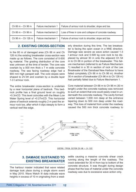
2. EXISTING CROSS-SECTION<br />
In the 60 m of damaged area (Ch 66 m and Ch<br />
126 m) the existing breakwater cross-section was<br />
made up as follows. The core consisted of 0-500<br />
kg material. The grading distribution of the core<br />
was unknown at the time of tender. The core was<br />
overlain by a 500 mm thick x 7 m wide concrete<br />
roadway. The sea facing roadway edge had a<br />
900 mm high parapet wall. The core slopes were<br />
shaped to 2V:3H and overlain by a double layer<br />
1-3 t armour rock.<br />
The entire breakwater cross-section is underlain<br />
by a near horizontal plane of bedrock. This bedrock<br />
profile has a final ground level on roughly<br />
+0.3mCD. This level coincides with the Mean Low<br />
Water Spring level of +0.27mCD. This horizontal<br />
plane of bedrock extends roughly 2 m past the armour<br />
rock toe, after which it dips steeply to form a<br />
vertical reef like edge.<br />
The harbour master indicated that wave related<br />
damage took place during a single storm event<br />
in May 2010. Wave Watch III data indicate wave<br />
heights in excess of 10 m originating from a westerly<br />
direction during this time. The lee breakwater<br />
is facing the open ocean in a NNE direction.<br />
Damage was severe as wave action caused 1-3<br />
t armour rock and 0-500 kg core rock to be displaced<br />
by almost 30 m onto the adjacent Ch 54<br />
m to Ch 66 m portion of the breakwater. This failure<br />
mechanism (referred to as Failure Mechanism<br />
1) resulted in a 30 m section of rock of the Lee<br />
Breakwater of the Gansbaai New Harbour to have<br />
failed completely (Ch 66 m to Ch 96 m). Another<br />
30 m section of breakwater (Ch 96 m to Ch 126 m)<br />
had partially failed due to Failure Mechanism 1.<br />
Core material between Ch 66 m to Ch 96 m (30 m<br />
length) under the concrete roadway was removed<br />
to such an extent that one could easily crawl in underneath<br />
the concrete roadway. The cavity formed<br />
varied between 1,000 mm deep at the entrance<br />
tapering down to 500 mm deep under the roadway.<br />
This loss of material from under the roadway<br />
caused the 500 mm thick concrete roadway to<br />
3. DAMAGE SUSTAINED TO<br />
EXISTING BREAKWATER<br />
settle causing a massive concrete shear crack<br />
running along the length of the roadway. The<br />
crack extended for 30 m from top to bottom of the<br />
concrete structure. It was thought during design<br />
phase that the loss of material under the concrete<br />
roadway was due to excessive wave action only.<br />
<strong>PIANC</strong> E-<strong>Magazine</strong> n° 144, November/novembre 2011<br />
12