

El Salvador - GFDRR
El Salvador - GFDRR
El Salvador - GFDRR

You also want an ePaper? Increase the reach of your titles
YUMPU automatically turns print PDFs into web optimized ePapers that Google loves.
<strong>El</strong> <strong>Salvador</strong><br />
Damage, Loss, and Needs Assessment<br />
for Disaster Recovery and Reconstruction<br />
after the low pressure system associated<br />
with Tropical Storm Ida<br />
Prepared by the Government of <strong>El</strong> <strong>Salvador</strong><br />
with the support of the international community<br />
November 2009
Table of Contents<br />
Acknowledgements.........................................................................................................iii<br />
Presentation...................................................................................................................... 1<br />
Summary and Conclusions............................................................................................... 3<br />
I. Description of the Event............................................................................................... 5<br />
A. Background............................................................................................................ 5<br />
B. November 2009 Event – Causes and Description..................................................... 6<br />
C. How Unusual is This Event? Historical Evidence of Similar Events........................... 17<br />
D. National and International Response..................................................................... 20<br />
Ii. Population and Affected Areas................................................................................. 23<br />
A. Analysis of Damages and Losses Caused by the Disaster........................................ 24<br />
B. Sectoral Damages and Losses................................................................................ 31<br />
B.1 Productive Sector.................................................................................................. 31<br />
B.2 Social Sectors........................................................................................................ 46<br />
B.3 Infrastructure Sectors............................................................................................ 73<br />
Iii. Cross-Cutting Issues.................................................................................................. 91<br />
A. Environmental Sector............................................................................................ 91<br />
B. The Disaster’s Impact on Women.......................................................................... 96<br />
C. Framework for Recovery....................................................................................... 99<br />
Iv. Economic Impact...................................................................................................... 101<br />
A. Impact of Tropical Storm Ida and the Tropical Depression..................................... 101<br />
B. Impact of the Disaster on Personal Income.......................................................... 110<br />
V. Risk Management..................................................................................................... 113<br />
A. Profile of Disaster Risks....................................................................................... 113<br />
B. Legal and Institutional Framework....................................................................... 115<br />
C. Strategic Framework for Risk Management......................................................... 117<br />
D. Summary of Risk Management Needs................................................................. 125<br />
Vi. Estimate of Recovery and Reconstruction Needs................................................. 127<br />
A. Background........................................................................................................ 127<br />
B. Recovery Needs................................................................................................... 129<br />
C. Reconstruction Needs......................................................................................... 132<br />
D. Needs for Risk Reduction.................................................................................... 133<br />
E. Early Recovery Needs.......................................................................................... 133
| iii<br />
ACKNOWLEDGEMENTS<br />
We wish to express our sincere thanks to the many men and women who made this<br />
assessment possible. This report was prepared by the Government of <strong>El</strong> <strong>Salvador</strong> under<br />
the coordination of the Technical Secretariat of the Presidency (Secretaría Técnica de la<br />
Presidencia -STP), with the key support of the National Bureau of Civil Protection and Disaster Prevention<br />
and Mitigation. During the assessment and the training conducted as part of it, we had the presence<br />
and full support of staff of the various relevant ministries and public sector institutions, as well as of<br />
departmental and municipal authorities, whose support made this report possible.<br />
The cross-cutting team of state institutions that participated includes:<br />
■■<br />
■■<br />
■■<br />
■■<br />
■■<br />
■■<br />
■■<br />
■■<br />
■■<br />
■■<br />
■■<br />
■■<br />
■■<br />
National Administration of Water Supply and Sewerage – Administración Nacional de<br />
Acueductos y Alcantarillados (ANDA)<br />
Central Reserve Bank – Banco Central de Reserva (BCR)<br />
National Registry Center – Centro Nacional de Registro (CNR)<br />
National Center for Agricultural, Livestock and Forestry Technology – Centro Nacional de<br />
Tecnología Agropecuaria y Forestal (CENTA)<br />
Accreditation Commission – Comisión de Acreditación (MH CDA)<br />
Executive Hydroelectric Commission of the Lempa River – Comisión Ejecutiva Hidroeléctrica del<br />
Río Lempa (CEL)<br />
Autonomous Executive Port Commission – Comisión Ejecutiva Portuaria Autónoma (CEPA)<br />
National Commission for Micro- and Small Businesses – Comisión Nacional de la Micro y<br />
Pequeña Empresa (CONAMYPE)<br />
Bureau of the National Territorial Studies Service – Dirección del Servicio Nacional de Estudios<br />
Territoriales (D-SNET)<br />
General Bureau of Statistics and Census – Dirección General de Estadística y Censos (DIGESTYC)<br />
General Bureau of Civil Protection – Dirección General de Protección Civil (DGPC)<br />
General Bureau of Plant and Animal Health, Ministry of Agriculture and Livestock – Dirección<br />
General de Sanidad Vegetal y Animal/Ministerio de Agricultura y Ganadería (GSVA / MAG)<br />
General Bureau of Forest, Watersheds and Irrigation Planning – Dirección General de<br />
Ordenamiento Forestal, Cuencas y Riego (DGOFCR)
iv | <strong>El</strong> <strong>Salvador</strong>: Damage, Loss, and Needs Assesment<br />
■■<br />
■■<br />
■■<br />
■■<br />
■ ■<br />
■■<br />
■■<br />
■■<br />
■■<br />
■■<br />
■■<br />
■■<br />
■■<br />
■■<br />
■■<br />
■■<br />
■■<br />
■■<br />
■■<br />
■■<br />
■■<br />
General Bureau of Agricultural and Livestock Economics – Dirección General de Economía<br />
Agropecuaria (DGEA)<br />
Center for the Development of Fisheries and Aquaculture – Centro de Desarrollo Pesquero y<br />
Acuícola (ENDEPESCA)<br />
Social Investment Fund for Local Development – Fondo de Inversión Social para el Desarrollo<br />
Local (FISDL)<br />
<strong>Salvador</strong>an Institute of Tourism – Instituto <strong>Salvador</strong>eño de Turismo (ISTU)<br />
<strong>Salvador</strong>an Institute of Social Security – Instituto <strong>Salvador</strong>eño del Seguro Social (ISSS)<br />
<strong>Salvador</strong>an Institute for Women’s Development – Instituto <strong>Salvador</strong>eño para el Desarrollo de la<br />
Mujer (ISDEMU)<br />
<strong>Salvador</strong>an Institute for the Comprehensive Development of Children and Adolescents –<br />
Instituto <strong>Salvador</strong>eño para el Desarrollo Integral de la Niñez y la Adolescencia (ISNA)<br />
Ministry of Agriculture and Livestock – Ministerio de Agricultura y Ganadería (MAG)<br />
Ministry of Economy – Ministerio de Economía (MINEC)<br />
Ministry of Education – Ministerio de Educación (MINED)<br />
Ministry of the Interior – Ministerio de Gobernación<br />
Ministry of Environment and Natural Resources – Ministerio de Medio Ambiente y Recursos<br />
Naturales (MARN)<br />
Ministry of Public Works - Ministerio de Obras Públicas<br />
Ministry of Public Health and Assistance of <strong>El</strong> <strong>Salvador</strong> – Ministerio de Salud Pública y Asistencia<br />
de <strong>El</strong> <strong>Salvador</strong> (MSPAS)<br />
Ministry of Labor and Social Welfare – Ministerio de Trabajo y Previsión Social (MTPS)<br />
Ministry of Tourism – Ministerio de Turismo (MITUR)<br />
Office of Sectoral Policies and Planning – Oficina de Políticas y Planifación Sectorial (OPPS)<br />
Secretariat of Culture – Secretaría de la Cultura<br />
Technical Secretariat of the Presidency – Secretaría Técnica de la Presidencia (STP)<br />
General Superintendency of <strong>El</strong>ectricity and Telecommunications – Superintendencia General de<br />
<strong>El</strong>ectricidad y Telecomunicaciones (SIGET)<br />
Vice Ministry of Housing and Urban Development – Viceministerio de Vivienda y Desarrollo<br />
Urbano (VMVDU)
Acknowledgement | v<br />
The external support team was composed of experts and specialists from the World Bank, the European<br />
Commission and the United Nations (UN) system, particularly the Economic Commission for Latin<br />
America and the Caribbean (Comisión Económica para América Latina y el Caribe -CEPAL), the Global Facility<br />
for Disaster Reduction and Recovery (<strong>GFDRR</strong>), 1 the United Nations Development Programme (UNDP),<br />
the Bureau for Crisis Prevention and Recovery (BCPR), the International Labour Organization (ILO), the<br />
Food and Agriculture Organization (FAO), the Pan American Health Organization (PAHO/WHO), the Joint<br />
Research Center of the European Commission (JRC) and the Norwegian Geotechnical Institute (NGI), with<br />
the coordinated efforts of other international agencies. The evaluation was joined by staff of the Inter-<br />
American Development Bank (IDB) and the International Monetary Fund (IMF).<br />
The study was coordinated by Lic. Jaime Acosta of STP; the Resident Coordinator of the United Nations<br />
System for <strong>El</strong> <strong>Salvador</strong> and Belize, Jessica Faieta; the World Bank representative in <strong>El</strong> <strong>Salvador</strong>, Alberto<br />
Leyton; the World Bank’s mission leader, Armando Guzmán; the representative of <strong>GFDRR</strong>, Doekle<br />
Wielinga; and Ricardo Zapata of CEPAL. The joint support mission (assessment mission) was composed of<br />
the following persons:<br />
-<br />
-<br />
-<br />
-<br />
-<br />
-<br />
-<br />
-<br />
-<br />
-<br />
-<br />
-<br />
-<br />
-<br />
-<br />
-<br />
-<br />
-<br />
Acosta, Alicia; agricultural sector, CEPAL (subregional headquarters in Mexico)<br />
Bambarén, Celso; impact on health, water and sanitation, PAHO/WHO<br />
Baraqui, Jaime; transportation and communications infrastructure<br />
Barathe, Richard, Deputy Resident Representative, UNDP–<strong>El</strong> <strong>Salvador</strong><br />
Corrales, Luis; risk management, environment, and water and sanitation infrastructure assessment,<br />
World Bank (Washington headquarters)<br />
Dickson, Eric; housing sector, World Bank (Washington headquarters)<br />
Gerhardinger, Andrea; Global Security and Crisis Management Unit, JRC<br />
Guzmán, Armando; Mission leader for World Bank assessment team, specialist in disaster risk<br />
management, World Bank (Washington headquarters)<br />
Jovel, Roberto; assessment of damages and losses and expert in energy assessment, <strong>GFDRR</strong>/World<br />
Bank (Washington headquarters)<br />
Orrego, Juan Carlos; UNDP/BCPR<br />
Ortega, Liudmila; impacts on livelihood and gender<br />
Rivas, Juan Carlos; macroeconomic analysis, CEPAL (subregional headquarters in Mexico)<br />
Salomón, Emilio; estimate of livelihoods and intensive employment recovery programs, ILO<br />
Sandersen, Frode; Deputy Division Director, Chief of Discipline – Avalanches, NGI<br />
Trianni, Giovanna; Global Security and Crisis Administration Unit, JRC<br />
Urzúa, Myriam; Focal Point for Disaster Evaluation, social sector, CEPAL (subregional headquarters in<br />
Mexico)<br />
Velasco, Osmar; risk management and housing, World Bank (offices in Guatemala)<br />
Villarreal, Francisco; macroeconomic analysis, non-agricultural productive sectors, CEPAL<br />
(subregional headquarters in Mexico)<br />
1<br />
Since its creation in September 2006, <strong>GFDRR</strong> has become an association of 25 countries and of regional and international<br />
organizations that are committed to aiding developing countries in reducing their vulnerability to natural risks and<br />
adapting to climate change.
vi | <strong>El</strong> <strong>Salvador</strong>: Damage, Loss, and Needs Assesment<br />
-<br />
-<br />
Wielinga, Doekle; Principal Specialist in Disaster Risk Management, <strong>GFDRR</strong>/World Bank (Washington<br />
headquarters)<br />
Zapata, Ricardo; Coordinator of the Regional Unit for Disaster Assessment, CEPAL (central<br />
headquarters in Santiago de Chile)<br />
Financial support for this assessment was provided by the European Community, the Global Facility<br />
for Disaster Reduction and Recovery (<strong>GFDRR</strong>), the United Nations Development Programme (UNDP) and<br />
the World Bank. In addition, the Royal Government of Norway provided its generous support to <strong>GFDRR</strong> in<br />
the conduction of the Post-Disaster Needs Assessment (PDNA). The photographs used in this publication<br />
were taken by the evaluation team, unless indicated otherwise.
| 1<br />
PRESENTATION<br />
At the request of the Government of <strong>El</strong> <strong>Salvador</strong>, through the Secretariat of the Presidency<br />
(Secretaría Técnica de la Presidencia -STP), a joint post-disaster needs assessment (PDNA)<br />
mission was conducted from November 18 to December 4, 2009. The mission was composed<br />
of a team of national and international experts.<br />
The assessment was conducted through the use of the damage and loss assessment methodology developed<br />
by the Economic Commission for Latin America and the Caribbean (CEPAL), and the assessment<br />
of humanitarian and community needs that incorporates methodologies of agencies of the United Nations<br />
System and UNDP for early recovery. The mission contributed elements for the government’s Rehabilitation<br />
and Reconstruction Strategy and Plan.<br />
With the government’s leadership and in direct contact with the Rehabilitation and Reconstruction<br />
Committee, 2 as well as with the contribution of other relevant ministries and institutions, a detailed sectoral<br />
assessment was conducted. For this purpose, training and coordination workshops, convened by the<br />
STP were carried out; conversations were held with various ministers and field visits were conducted by<br />
specialized teams. On scientific matters, satellite images were used and a technical analysis of landslides<br />
was prepared by specialists of the Norwegian Geotechnical Institute.<br />
This report presents the results of a comprehensive assessment, based on the information available to<br />
the mission members until the end of the mission. The opinions expressed do not jeopardize the Government<br />
of <strong>El</strong> <strong>Salvador</strong> or the institutions sponsoring and participating in it.<br />
2<br />
Executive Decree No. 89, issued in the Presidential House on November 26, 2009 and published in the Official Gazette,<br />
volume 385, number 223 dated November 27, 2009, created the National Committee for Rehabilitation and Reconstruction<br />
(the Committee), formed by: a) the Technical Secretary of the Presidency of the Republic, who acts as its Coordinator; b)<br />
the Secretary of Social Inclusion; c) the State Ministers and Deputy Ministers; d) the General Director of Civil Protection<br />
and Disaster Prevention and Mitigation; and e) the heads of Autonomous Institutions. The Committee has the following<br />
duties: a) to define and oversee the rehabilitation and reconstruction strategy, which includes a medium- and long-term<br />
vision; one of its key components is disaster mitigation and prevention; and b) to establish the priorities to be addressed<br />
in the strategic context of rehabilitation and reconstruction.
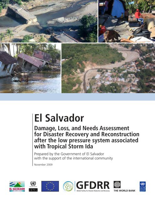
The event that took place on this occasion is associated with heavy<br />
precipitation totaling over 450 mm in a three-day period (November 7<br />
to 9, 2009), with a maximum intensity of 355 mm in a five-hour period<br />
during which the landslides and catastrophe occurred.<br />
Vuelo CEPAL UN21_11_20096376.JPG
| 3<br />
SUMMARY AND CONCLUSIONS<br />
Through the use of the damage and loss assessment methodology developed by the Economic<br />
Commission for Latin America and the Caribbean (CEPAL) and the humanitarian and community<br />
needs assessment that incorporates methodologies of agencies of the United Nations System<br />
and UNDP for early recovery, the mission contributed elements for the government’s Rehabilitation and<br />
Reconstruction Strategy and Plan.<br />
With the government’s leadership and in direct contact with the Rehabilitation and Reconstruction<br />
Committee, as well as with the contribution of other ministries and relevant institutions, a detailed sectoral<br />
assessment was conducted. For this purpose, training and coordination workshops convened by the<br />
STP were conducted and conversations were held with several line ministers.<br />
The number of disasters generated by natural events in <strong>El</strong> <strong>Salvador</strong>, according to data from national<br />
studies and those collected in international databases, as well as evaluations conducted by CEPAL, shows<br />
the high risk that the country faces, especially due to its economic and social vulnerability. Historical data 3<br />
confirm <strong>El</strong> <strong>Salvador</strong>’s high index of risk in the event of disasters and the heavy weight of climate events in<br />
this total, with costs in general not sufficiently measured. If database information is used, such as that from<br />
the Centre for Research on the Epidemiology of Disasters (CRED) at the University of Louvain in Belgium and<br />
the evaluations conducted by CEPAL over the years (since 1972), the country has had nearly 6,500 deaths,<br />
with an economic cost that is only partially assessed and that could be over US$16 billion in 2008 dollars. Of<br />
these events, those of a climate nature generated over 62% of deaths and between 87% and 95% of impacts,<br />
according to the source. Due to the limitation of the CEPAL sample and the fact that the economic<br />
assessment is partial and generally limited when the complete damage and loss methodology has not<br />
been used, the estimated economic impact could be less than 68% of the impact that actually occurred.<br />
The event that took place on this occasion is associated with heavy precipitation totaling over 450 mm<br />
in a three-day period (November 7 to 9, 2009), with a maximum intensity of 355 mm in a five-hour period<br />
during which the landslides and catastrophe occurred. This figure corresponds to nearly five times the<br />
average precipitation expected for the month of November. The lahars 4 that hurled down over Verapaz,<br />
where the greatest numbers of deaths took place, occurred in the early morning of November 8.<br />
Based on historical data, it may be inferred that critical situations for disaster events with a large<br />
number of victims occur with relatively high frequency: every 10 to 30 years in the country, due to climate<br />
events.<br />
3<br />
Ministry of Environment and Natural Resources (MARN), historical compendium of disasters in <strong>El</strong> <strong>Salvador</strong> 1900–2005,<br />
publication by D-SNET and UNDP, 2008 (ISBN 978-99923-868-1-1, see also OFDA CRED Emergency Events Database EM-<br />
DAT, at http://www.emdat.be/) and the assessments conducted by CEPAL since the 1970s in the country (www.cepal.org,<br />
click on “disasters” button).<br />
4<br />
Lahars are flows of mud, water and other materials. (See footnote #7 for a detailed definition.)
4 | <strong>El</strong> <strong>Salvador</strong>: Damage, Loss, and Needs Assesment<br />
On the basis of families that lost their homes or were displaced from them in the emergency, and taking<br />
into account the income losses that occurred as a consequence of the disaster, it has been estimated<br />
that the population affected in a primary and secondary manner totals just over 122,000.<br />
Based on the use of the disaster assessment methodology developed by CEPAL since 1972, it has been<br />
estimated that, besides suffering the regrettable loss of human lives, the value of damages and losses caused<br />
by the November 2009 disaster in <strong>El</strong> <strong>Salvador</strong> totals US$314.8 million, which represent the equivalent of<br />
1.44% of the country’s gross domestic product (GDP). Of the entire economic effect, US$210.7 million correspond<br />
to the destruction of assets (66.9% of total damages and losses), while the remaining US$104.1<br />
million represent changes in economic flows and include both production losses and higher service costs<br />
(33.1% of the total). Of the total amount of damages and losses, 63.3% (US$199.3 million) refers to<br />
public property, while 36.7% (US$115.5 million) refers to private property (see Chapter II, Table 7), a ratio<br />
that illustrates the relative effort that each of these sectors will have to make in recovery activities.<br />
The magnitude of the disaster at national level is limited. However, when geographically more disaggregated<br />
values are examined, the tragedy caused by this event can be better visualized. It is worth noting<br />
that the impact of the disaster was concentrated in 5 of the country’s 14 departments, accounting for<br />
nearly 85% of damages and losses. There is an inverse relationship between the higher value of damages<br />
and losses per person, and the relationship between these effects and the GDP, with regard to the current<br />
year’s Human Development Index (HDI). This implies damages and losses to the livelihoods of segments of<br />
the population with high levels of economic and social vulnerability. These have been concentrated on the<br />
population that suffered the partial or total loss of their homes and assets.<br />
Different types of needs with a different degree of urgency and duration are drawn from this impact<br />
profile. With information on the quantification of damages and losses, and information on the requirements<br />
expressed by the various sectors consulted, a table of recovery and reconstruction needs has been<br />
prepared, detailing by principal sectors the amounts needed for each type of intervention. In summary, the<br />
amount needed for recovery is estimated at US$105.9 million, which would be used between December<br />
2009 and June 2010, before the next rainy season starts in the country, while the total amount needed<br />
for reconstruction is estimated at US$149 million, to be used between the end of 2009 and 2014 (see<br />
Chapter VI, Table 47). Added to these are immediate needs for early recovery and, in the short and long<br />
terms, for undertaking substantial risk reduction efforts.<br />
The country needs to adopt an explicit risk reduction strategy in view of the recurrence of this type of<br />
phenomena and historical experience. Moreover, this event presents an opportunity to make significant<br />
changes in the pattern of spatial development and the development of economic and social sectors which<br />
must be given greater attention due to their potential and their vulnerability.<br />
In effect, a strategic framework of risk management is recommended, combining specific elements<br />
found in <strong>El</strong> <strong>Salvador</strong> and lessons learned from international experience. The principles that underlie this<br />
framework are: (i) human loss and the economic impact of disasters may be reduced through pre-disaster<br />
planning and investments in prevention; and (ii) the strategic framework and the action plan are effective<br />
in terms of cost and implementation. The pillars of the Risk Management Framework and their description<br />
are presented in Chapter V.
| 5<br />
I. DESCRIPTION OF THE EVENT<br />
A. BACKGROUND<br />
As indicated by the Bureau of the Territorial Studies Service (Dirección del Servicio de Estudios Territoriales<br />
-D-SNET) of the Ministry of Environment and Natural Resources of <strong>El</strong> <strong>Salvador</strong>, 5 the country, “due to<br />
its geomorphology, geographic location and orography is exposed to threats of natural origin such as<br />
hurricanes, floods, earthquakes, landslides, volcanic eruptions, the phenomenon of the <strong>El</strong> Niño Southern<br />
Oscillation (ENSO–<strong>El</strong> Niño/La Niña phases), which, when they impact the territory, cause economic losses<br />
and damages to homes, infrastructure, transportation and agriculture, service interruption, etc.”<br />
The number of disasters generated by natural events in <strong>El</strong> <strong>Salvador</strong>, according to data from national<br />
studies and those collected in international databases, as well as evaluations conducted by CEPAL, shows<br />
the high risk that the country faces, especially due to its economic and social vulnerability. Historical data 6<br />
confirm <strong>El</strong> <strong>Salvador</strong>’s high index of risk in the event of disasters and the heavy weight of climate events in<br />
this total, with costs in general not sufficiently measured. If database information is used, such as that from<br />
the Centre for Research on the Epidemiology of Disasters (CRED) at the University of Louvain in Belgium and<br />
the evaluations conducted by CEPAL over the years (since 1972), the country has had nearly 6,500 deaths,<br />
with an economic cost that is only partially assessed and that could be over US$16 billion in 2008 US dollars.<br />
Of these events, those of a climate nature generated over 62% of deaths and between 87% and<br />
95% of impacts, according to the source. Due to the limitation of the CEPAL sample and the fact that the<br />
economic assessment is partial and generally limited, when the methodology that counts both damages<br />
and losses has not been used, it is estimated that the reported amount of the economic cost could be less<br />
than 68% of the impact that actually occurred.<br />
TABLE 1. COMPARISON OF THE IMPACT OF DISASTERS ACCORDING TO CEPAL AND CRED<br />
Deaths Population affected Damages (CRED)<br />
Impact (CEPAL)<br />
(in millions of US$)<br />
Total 6,934 2,867,172 15,196 13,806<br />
Total climate events 4,313 1,089,791 13,232 13,060<br />
Climate events with respect to totals 62.20% 38.01% 87.07% 94.60%<br />
Source: Prepared by the CEPAL Disaster Unit based on the database of economic and social assessments conducted in <strong>El</strong> <strong>Salvador</strong> and<br />
on CRED_EM-DAT data (http://www.emdat.be/disaster-list) and reliefweb.<br />
5<br />
Based on reports by the Bureau of the National Territorial Studies Service (D-SNET) of <strong>El</strong> <strong>Salvador</strong>, Report on flows of debris<br />
(landslides) in the cities of Verapaz, Guadalupe the outskirts of Tepetitán, November 2009, and with the contribution of<br />
the Norwegian Geo-Technical Institute (NGI).<br />
6<br />
Ministry of Environment and Natural Resources (MARN), historical compendium of disasters in <strong>El</strong> <strong>Salvador</strong> 1900–2005,<br />
publication by D-SNET and UNDP, 2008 (ISBN 978-99923-868-1-1; see also OFDA CRED Emergency Events Database EM-<br />
DAT, at http://www.emdat.be/) and the assessments conducted by CEPAL since the 1970s in the country (www.cepal.org,<br />
under “disasters”).
6 | <strong>El</strong> <strong>Salvador</strong>: Damage, Loss, and Needs Assesment<br />
It is difficult to establish a trend regarding whether the recurrence or frequency of these events is<br />
increasing as a consequence of climate change processes, although their economic cost has undoubtedly<br />
grown exponentially. Even on a partial basis (only those events that the country’s government has<br />
requested are evaluated), the average annual impact of this type of disasters is around 160,000 people<br />
affected, with damages of nearly US$470 million and losses of nearly US$220 million. Their weight in the<br />
GDP is 4.2%, while damages represent over 20% of gross capital formation (GCF). Although this average<br />
is biased by the large-scale events that occurred (Hurricane Mitch, the 1986 and 2001 earthquakes,<br />
principally), these evaluations do not take into account the “everyday disasters” or small-scale events that<br />
the country suffers each year—particularly recurring floods and landslides in the rainy season—, especially<br />
affecting the most vulnerable zones in urban areas and disadvantaged agricultural producers, on slopes<br />
and riverbanks that are regularly flooded.<br />
TABLE 2. EL SALVADOR: STATISTICS OF EVENTS EVALUATED BY CEPAL, 1982–2005<br />
Population affected Total (in millions of US dollars, 2007) Relation<br />
of total<br />
Deaths Direct Total Damages Losses<br />
External<br />
effect<br />
impact to<br />
preceding<br />
GDP<br />
Damages<br />
with<br />
respect to<br />
preceding<br />
GCF<br />
Total events<br />
evaluated 3,385 3,648,343 15,763 10,743 5,020 3,357 32.3% 160.5%<br />
Average per<br />
event 564 608,057 2,627 1,791 837 559 16.1% 80.2%<br />
Average per<br />
year during<br />
the period 147 158,624 685 467 218 146 4.2% 20.9%<br />
Source: CEPAL assessments (1982–2005).<br />
B. NOVEMBER 2009 EVENT – CAUSES AND DESCRIPTION<br />
The event that occurred on this occasion is associated with heavy precipitation that totaled over 450<br />
mm in a three-day period (November 7 to 9, 2009), with a maximum intensity of 355 mm in a five-hour<br />
period during which landslides occurred and rivers overflowed their banks. This figure corresponds to<br />
nearly five times the average precipitation expected for the month of November. The lahars 7 that hurled<br />
down over Verapaz, where the greatest numbers of deaths took place, occurred in the early morning<br />
(around 2:00 a.m. on November 8, 2009).<br />
7<br />
A lahar (or mudflow) is a flow of mud moving down from the slopes of stratovolcanoes. In recent centuries, lahars have<br />
destroyed more public or private property than any other volcanic process and have caused the losses of thousands of<br />
human lives. Lahars, together with falling tephra, are the principal cause of risks associated with volcanoes. Lahars may<br />
occur due to:<br />
1. Intense rainy periods, not necessarily coinciding with periods of volcanic activity.<br />
2. Glaciar fusion in the upper parts of a volcano during volcanic activity.<br />
3. Emptying of a crater lake located at the top of a volcano.<br />
4. Collapse of slopes due to prolonged hydrothermal alteration or earthquake.<br />
Unlike landslides of debris, lahars are humid deposits where water influences both the genesis and the transport of the<br />
remobilized mass (http://es.wikipedia.org/wiki/Lahar)
I. DESCRIPTION OF THE EVENT | 7<br />
The intense rain also resulted in flooding and erosion in rivers and landslides on steeper slopes. The<br />
mix of water, mud and sediment—material carried by the current—saturated riverbeds, already considerably<br />
silted by prior events, causing widespread flooding on the plain and affecting settlements, towns and<br />
urban areas, with damages to urban, rural and transport infrastructure.<br />
In addition, the lahar on slopes caused significant soil losses, and floods caused sediment to accumulate<br />
on agricultural lands, with damages to terrain and plantations and crop losses.<br />
Tropical Storm Ida began November 4 th on the Atlantic coast of Nicaragua, near Bluefields. By the<br />
next day, Thursday the 5 th , it had become a hurricane (Level 1 on the Saffir-Simpson scale). Upon making<br />
landfall in Nicaragua, it lost strength as it moved to the northwest. On Friday the 6 th , now only a tropical<br />
depression, it continued moving and crossed Honduras on a north-northwesterly path, while a lowpressure<br />
front persisted in the direction of southwestern <strong>El</strong> <strong>Salvador</strong>, causing the abundant humidity to<br />
move toward this country.<br />
IMAGE 1. IDA’s PATH AND IMAGE OF RECORDED RAINFALL<br />
Source: Joint Research Center of the European Commission (JRC).
8 | <strong>El</strong> <strong>Salvador</strong>: Damage, Loss, and Needs Assesment<br />
Ida again gained strength on Saturday, November 7 th , when it entered the Caribbean, strengthening<br />
between 9:00 and 10:00 p.m. By 10:00 p.m. on Saturday, rain had increased significantly in the Departments<br />
of San <strong>Salvador</strong>, La Paz and San Vicente. Ida was reclassified as a Category 1 hurricane at 11:15<br />
p.m. Associated with the low-pressure system, it continued to cause intense, ongoing precipitation in San<br />
<strong>Salvador</strong> between 8:00 p.m. on Saturday and 2:00 a.m. on Sunday, November 8 th . In the Departments<br />
of La Paz and San Vicente the heaviest rainfall occurred at 10:00 p.m. on Saturday and at 4:00 a.m. on<br />
Sunday, November 8, 2009.<br />
The weather station that recorded the greatest accumulated precipitation was that located at the San<br />
Vicente (Chinchontepec) volcano, totaling 355 mm (with a maximum intensity of 81 mm per hour and<br />
317 mm in 7 hours). The spatial distribution of rainfall shows the heaviest concentration in the Departments<br />
of San <strong>Salvador</strong>, La Paz and San Vicente. On Sunday, November 8 th , the low-pressure system continued<br />
along <strong>El</strong> <strong>Salvador</strong>’s coastline, gradually weakening.<br />
IMAGE 2. RAINFALL RECORDED ON NOVEMBER 7, 2009<br />
Source: Joint Research Center of the European Commission (JRC).<br />
The intense rain and most of the landslides were concentrated on the steeper slopes in an area of<br />
approximately 400 km 2 between Lake Ilopango and the San Vicente volcano. Consequently, the greatest<br />
impact was observed on the northern side of the volcano and on slopes to the south and southeast of<br />
Lake Ilopango. The most affected slopes face northward.
I. DESCRIPTION OF THE EVENT | 9<br />
IMAGE 3. MUNICIPALITIES AFFECTED BY TROPICAL STORM IDA IN EL SALVADOR<br />
Source: Joint Research Center of the European Commission (JRC).<br />
1. Description of Types of Landslides<br />
The following types of landslides were observed:<br />
a) Lahars. Flow of materials and mud composed of pyroplastic material8 and water on the slopes<br />
of a volcano, generally following the course of a river in a valley. Lahars were the principal type<br />
of landslide on the San Vicente volcano.<br />
b) Shallow landslides. In this type of landslide, the runoff surface is within the soil layer or eroded<br />
rocks, at depths ranging from decimeters to several meters. These landslides predominated on<br />
the slopes surrounding Lake Ilopango.<br />
c) Depressions. These consist of massive erosion that occurs when unstable or unconsolidated<br />
materials move a short distance over a slope. The landslide area may be a raised concave or<br />
flat. Many of these depressions occurred along road slopes.<br />
8<br />
Pyroplastic flow: a phenomenon that accompanies a volcano’s eruption, also called a pyroclastic cloud, pyroclastic lava or<br />
glowing cloud. It happens when lava with a high gas content cools and decompresses upon reaching the surface during<br />
a volcanic eruption. http://www.wikiteka.es
10 | <strong>El</strong> <strong>Salvador</strong>: Damage, Loss, and Needs Assesment<br />
d) Falling rocks (rock fragments that fall or roll from steep cliffs, as observed in a large part of the affected<br />
zone).<br />
IMAGE 4. PRINCIPAL CREEKS THAT WERE ACTIVATED DURING THE RAINS OF NOVEMBER 7<br />
AND 8, 2009, ON THE NORTHERN SLOPE OF THE SAN VICENTE VOLCANO<br />
Source: Joint Research Center of the European Commission (JRC).
I. DESCRIPTION OF THE EVENT | 11<br />
IMAGE 5. LANDSLIDES<br />
Source: Google Earth with contribution from CEPAL.<br />
IMAGE 6. EROSION ON THE SLOPES OF SAN VICENTE VOLCANO<br />
Pozo Caliente Creek<br />
<strong>El</strong> Chilatero Creek<br />
Infiernillos Creek<br />
Natural creek bed<br />
Part of the lahar that<br />
reached Verapaz<br />
Photos: SNET/MARN
12 | <strong>El</strong> <strong>Salvador</strong>: Damage, Loss, and Needs Assesment<br />
2. Triggers<br />
The main triggers of landslides were the rains that took place from November 7 to 8. The rain had two severe<br />
consequences: an increase in water flow in natural drainage channels on the lower slopes of the San<br />
Vicente (Chinchontepec) volcano, and an increase in the pressure of water runoff on deposits of loosely<br />
compacted materials and on bedrock.<br />
Due to the wind from the north that accompanied the precipitation, the slopes facing this direction<br />
experienced rain gusts that generated major environmental humidity which cooled when it encountered<br />
an obstacle. The increased runoff resulted in erosion on the floor of river channels and on riverbanks.<br />
Cuts on steeper slopes destabilized adjacent slopes and caused an increase in the materials that<br />
flowed toward streams. The slope also gave rise to the accumulation of runoff pressure which reduced<br />
the slope’s stability. When a large part of the slope totally collapsed, river streams were blocked and the<br />
rupture of these obstructions, due to pressure, caused the lahars. All of these processes caused a flow of<br />
water with a high concentration of sediments. When the discharge of this mixture exceeds a critical value,<br />
the flow becomes a lahar. Under these circumstances, the mass does not behave according to classic laws<br />
of hydraulics and what scientists call “non-Newtonian flows” occur, since the ratio of water to solids is<br />
less than 1 and sometimes reaches values of 0.50 or even less. Next, sedimentation of materials occurs<br />
when the lahars reach less steep slopes, at the foot of the volcano, clogging channels and reducing the<br />
rivers’ carrying capacity (drainage or load). This caused new river courses to open, the most notable case<br />
being that of Verapaz. Another element in this process is the pulsating character of the flow: the frontal<br />
part of the lahar contains thicker materials that reduce its speed, causing dams which, when they break<br />
up, make a new acceleration possible. Eyewitnesses in Verapaz observed several surges prior to the main<br />
landslide that devastated the city.<br />
Smaller lahars continued along the channels of rivers without entering towns, although the volumes<br />
of materials filled these channels and caused them to overflow in several directions, affecting nearby lands<br />
and vast populated zones. Measurements by D-SNET and MARN make it possible to estimate the magnitude<br />
of the principal lahars that surged from the San Vicente volcano.<br />
Stream<br />
(population affected)<br />
TABLE 3. CHARACTERISTICS OF LAHARS ON SAN VICENTE VOLCANO<br />
Sedimentation area<br />
Thickness of<br />
sedimentation<br />
Volume of<br />
sedimentation<br />
Runoff distance<br />
<strong>El</strong> Derrumbo (Guadalupe) 250,000 m 2 0.5 – 2.5 m 360,000 m 3 6 km<br />
La Quebradona (Verapaz) 150,000 m 2 0.5 – 2.0 m 250,000 m 3 6 km<br />
<strong>El</strong> Amate Blanco (Tepetitán) 250,000 m 2 0.5 – 2.0 m 300,000 m 3 6 km<br />
Source: D-SNET/MARN.
I. DESCRIPTION OF THE EVENT | 13<br />
Specialized literature 9 offers models to determine the speed historically achieved by lahars. A “typical”<br />
lahar can reach great speed on a volcano’s steepest slope (up to 50 m/s). In the upper part of the alluvial<br />
fan, speed may vary from 15 m/s to 25 m/s, while in the lower part, in the fan’s softest zone, it may vary<br />
from 5 m/s to 15 m/s. However, it is surprising how lahars are able to maintain their movement for many<br />
kilometers, even on nearly flat lands (as occurred on the coastal plains of the Department of La Paz). The<br />
lahars moved 6 to 10 kms, carrying rocks weighing 10 to 20 tons, with slopes no steeper than 2 to 3 o . This<br />
was possible due to the high water content that reduced friction on the stream bed to nearly zero.<br />
The cut of the section of the lahar that flowed over Verapaz measured nearly 100 m 2 . With a flow<br />
speed of 10 m/s, the discharge must have been around 1,000 m 3 /s. Damage to vegetation and buildings<br />
in Verapaz shows that the lahar had a height of about 3 meters. If one assumes a speed of 10 m/s on the<br />
vertical wall, pressure would have been around 200 kPa (kiloPascals per area), which corresponds to 20<br />
ton/m 2 , a force that even highly resistant buildings could not have withstood.<br />
9<br />
• Kinematic models of straight-line movement of flows:<br />
a) V = Vo + gt; where V: final speed (m/s), Vo: initial speed (m/s), a: acceleration of movement (m/s 2 ), and t: arrival time<br />
at stabilization zone (seconds).<br />
b) e = Vot + 1/2gt2; where e: the scope of material conveyed (in km).<br />
c) V2 = Vo2 + 2gh.<br />
• Darcy Law to determine the discharge of material conveyed in m3/seconds.<br />
Q = V. A; V: speed of flow (m/s), A: section of channel through which the flow moves given m 2<br />
• Mathematical model of relationship for the calculation of geometric parameters of mudflow:<br />
V = Width (A, given in meters) x Length (l, given in meters) x Thickness (E, given in meters) = m 3 ; where E: is the scope<br />
of material conveyed in km; and A = width x l given in m 2 , being the physical area occupied by the mudflow.
14 | <strong>El</strong> <strong>Salvador</strong>: Damage, Loss, and Needs Assesment<br />
GRAPH 1. RECORDED PRECIPITATION<br />
Precipitation recorded during the period between 7:00 a.m. on November 7 th and 7:00 a.m. on<br />
November 8 th at the weather stations of San Vicente, Tepezontes, Boquerón and Ilopango.<br />
Source: D-SNET/MARN.<br />
The key factors that contributed to the magnitude of the lahars were:<br />
a) The prior saturation of soils when rain intensity increased; thus the rain fell directly on the<br />
runoff area, making response time very short.<br />
b) The intensity of precipitation was high (over 20 mm/hr) over a long period of 7 hours and at an<br />
excessive level for 3 hours, causing extreme runoff.<br />
c) The presence of abundant eroded material, accumulated in river streams, increasing the<br />
sediment conveyed during the flood. The presence of this silt is associated with the 2001<br />
earthquakes that caused various landslides and the depositing of materials in river channels.
I. DESCRIPTION OF THE EVENT | 15<br />
As consequence of all this, the mission noted that the towns and cities located near rivers adjacent to<br />
the San Vicente volcano directly suffered the impact of the lahars that flowed along the main river channels,<br />
with severe consequences on housing and urban infrastructure in Verapaz, San Vicente and Guadalupe.<br />
Likewise, homes and towns, including a vacation center, located on the banks of Lake Ilopango were<br />
covered by landslides and their foundations were eroded due to the action of water. The destruction of<br />
bridges and damage to culverts and drains along many roads were significant. In others, cuts occurred due<br />
to deposits of loose materials, rocks and mud. Extensive areas used for agriculture on alluvial fans were<br />
covered with gravel and sand due to flooding. Sedimentation from mud deposits in numerous rivers and<br />
especially in Lake Ilopango caused floods and the lake’s natural drainage was blocked. This drainage had<br />
already been blocked during the 2001 earthquakes and the incomplete drainage work and construction<br />
of a drainage system collapsed due to the erosion of gabions and walls, exposing its fragility due to the<br />
narrowness of the outlet.<br />
Schematically, the event is described as follows: in terms of climate, a combination of a low-pressure<br />
system and a tropical storm occurred, causing high levels of concentrated rainfall (from a return level between<br />
100 and 300 years), with differential consequences:<br />
a) At the San Vicente (Chinchontepec) volcano, lahars occurred; in geology these are called<br />
“torrential landslides on volcanic lands.”<br />
b) A very large amount of solids, in a proportion of 0.60 to 1 with respect to water.<br />
c) In the lower courses of rivers, the prior siltation of streams in their channnels caused more<br />
widespread flooding.<br />
When the current reached the coastal strip, which is elevated with respect to the plain and in which<br />
highways parallel to the coast, resorts and beach houses have been constructed, the coast’s natural drainage<br />
was obstructed and the mouths of rivers overflowed, causing new outlets to open that brought about<br />
destruction on the coast.
16 | <strong>El</strong> <strong>Salvador</strong>: Damage, Loss, and Needs Assesment<br />
IMAGE 7. LANDSLIDES AND LAHARS<br />
Start of flow<br />
of debris<br />
Source: D-SNET
I. DESCRIPTION OF THE EVENT | 17<br />
C. HOW UNUSUAL IS THIS EVENT? HISTORICAL EVIDENCE OF SIMILAR EVENTS<br />
With regard to the extreme rainfall, according to historical records and recorded landslides, and with<br />
respect to climate events that affect the country, this event is neither unusual nor infrequent. There is<br />
information on previous events and there are records from the last 100 years about various lahars with<br />
disastrous consequences in the San Vicente area. Most of them were the result of intense rains (lasting 5<br />
to 7 days straight, according to witnesses’ testimonies).<br />
BOX 1. THE SEVEREST LAHARS IN EL SALVADOR<br />
1774: Lahar on the northeastern slope of the volcano, affecting the city of San Vicente.<br />
1912: Lahar totally destroys Verapaz, causing numerous deaths both in Verapaz and in Agua Agria, a<br />
village higher up on the slope of the volcano.<br />
1934: Total destruction of Tepetitán by a lahar that originated in <strong>El</strong> Blanco creek, with numerous victims<br />
(for this reason, Nueva Tepetitán was founded). Likewise, Guadalupe was struck in 1934 by a<br />
lahar that originated in <strong>El</strong> Derrumbo creek, destroying various houses and causing victims.<br />
1996: On the southern slope of the volcano, a landslide blocked the main road between Tecoluca and<br />
Zacatecoluca.<br />
2001: Landslides caused by the February 13 th earthquake on the northern and northwestern slopes<br />
flowed toward the valley although they did not become lahars. However, the landslides deposited<br />
over 200,000 cubic meters of sediments in the channels that drain the volcano, and thus the<br />
instability of these sediments represents an increased risk for floods and lahars downstream<br />
toward Guadalupe, Verapaz and Tepetitán, as demonstrated in 2009.<br />
2001: On September 15 th , Guadalupe was struck by a lahar from <strong>El</strong> Derrumbo creek, triggered by rains.<br />
There was one victim and numerous houses were destroyed in approximately the same zone that<br />
was affected by the 1934 event.<br />
2005: Tropical Storm Stan produced several landslides on the eastern shore of Lake Ilopango.<br />
The period of return (recurrence) of situations with intensities similar to the current one is difficult to<br />
estimate due to the lack of continuous series of precipitation by hour per day. However, it may be stated<br />
that a critical factor was the 7-hour period of rain. The major damages caused by landslides appear to be<br />
associated with the presence of tropical storms lasting 3 to 4 days. If rains occur for periods of 5 to 10<br />
hours, with per-hour intensities over 30 to 50 mm in the final phase of a storm or depression, when the<br />
soil is saturated it is almost certain that a catastrophic event will occur.
18 | <strong>El</strong> <strong>Salvador</strong>: Damage, Loss, and Needs Assesment<br />
TABLE 4. MAXIMUM LEVELS OF PRECIPITATION RECORDED IN THE ZONE OF SAN VICENTE<br />
Tropical Storm 24 hrs. 48 hrs. 72 hrs. 96 hrs.<br />
Fifi (1974) 252.8 379.1 394.1 404.0<br />
Mitch (1998) 314.5 387.6 415.6 419.2<br />
Adrián (2005) 256.6 271.4 296.0<br />
Stan (2005) 207.2 411.5 580.5 705.4<br />
Ida (2009) 355.0 >400 >450<br />
Source: National Territorial Studies Service (D-SNET), Ministry of Environment and Natural Resources (MARN).<br />
The maximum critical levels of precipitation that cause landslides in the zone of San Vicente during<br />
tropical storms are above 200 mm and rain that exceeds 300 mm.<br />
GRAPH 2. MAXIMUM LEVELS OF PRECIPITATION RECORDED IN THE ZONE OF SAN VICENTE<br />
DURING RECENT EXTREME EVENTS<br />
Source: Prepared by CEPAL.<br />
Using historical data, it may be inferred that critical situations for disaster events with a large number<br />
of victims occur with relatively high frequency every 10 to 30 years in the country due to climate events.<br />
A high intensity of rain can also affect other regions but, based on available evidence, the zones of San<br />
Vicente and Ilopango have greater exposure. Lahars of similar magnitude may be assumed to have a period<br />
of recurrence of nearly 50 years, and those that originated in San Vicente appear to have the greatest
I. DESCRIPTION OF THE EVENT | 19<br />
potential for occurring in the country. If one also takes into account the potential that, due to climate<br />
change, there is a greater frequency of rain events above historical averages, similar episodes could occur<br />
with greater frequency in the future. This only reinforces the need for immediate preventive actions in<br />
order to prepare for future destructive lahars.<br />
GRAPH 3. TIMETABLE OF EARTHQUAKES AND VOLCANIC ERUPTIONS<br />
IN THE SAN SALVADOR METROPOLITAN REGION<br />
Source: Prepared by CEPAL.<br />
To complete the array of threats that the country faces, the periods of recurrence and intensity of impact<br />
of seismic events and volcanic activity are considered. The periods of recurrence in this type of events<br />
with a high level of damage are around 26 years, and the period of recurrence for events with light to<br />
moderate levels of damage is 17 years. All of this reinforces the notion that comprehensive, cross-cutting<br />
risk management measures are needed in all sectors and activities as part of the development strategy,<br />
strengthening intersectoral and intraregional cooperation. This is also a clear indication that the country<br />
requires not only structural and non-structural measures (such as appropriate early-warning, monitoring<br />
and response systems), but also measures to transfer and spreading out the risk—at microeconomic level<br />
and focusing on sectors with fewer resources and less capacity as well as at macroeconomic level to protect<br />
social budgets and state investments.
20 | <strong>El</strong> <strong>Salvador</strong>: Damage, Loss, and Needs Assesment<br />
D. national and international response<br />
Based on the weather forecast issued by the Ministry of Environment and Natural Resources, through the<br />
Bureau of the National Territorial Studies Service (MARN/D-SNET), on November 5, 2009 the General Bureau<br />
of Civil Protection and Disaster Prevention and Mitigation declared a preventive Green Alert throughout all<br />
of <strong>El</strong> <strong>Salvador</strong> and began to issue communiqués to place municipal and departmental governments on alert<br />
and to ready their respective Departmental and Municipal Civil Protection Commissions. On November 8 th<br />
the level of alert was raised to Orange in the five municipalities most affected by the disaster.<br />
The first response by the National Civil Protection System was to activate the seven Sectoral Technical<br />
Commissions for Civil Protection: emergency services, logistics, security, shelters, technical-scientific services,<br />
infrastructure and health. The initial operational actions were undertaken by all government agencies<br />
related to addressing the emergency; these agencies carried out efforts to rescue victims, evacuate<br />
the population and transfer people to shelters.<br />
On Monday, November 7 th , the President of the Republic issued Decree Nº 73 which declared the<br />
State of Emergency throughout the entire country. Legislative Decree 175 dated November 9 th was also<br />
issued; this decree declared a State of Catastrophe. Later, the Legislative Assembly issued Decree 179 on<br />
December 12, 2009 in order to redirect resources to handle the emergency.<br />
In addition, the Legislative Assembly issued Decree 178 which allows Municipal Councils to use<br />
resources from the Economic and Social Fund (Fondo Económico y Social -FODES) to allocate resources<br />
from the months of November and December to address the consequences of the climate phenomenon.<br />
The Minister of the Interior asked the Minister of Finance to appropriate US$3.5 million from the Civil<br />
Protection and Disaster Prevention and Mitigation Fund (Fondo de Protección Civil, Prevención y Mitigación<br />
de Desastres -FOPROMID) to deal with the short-term emergency. During the emergency’s development,<br />
56 temporary shelters were put into operation, aiding nearly 10,400 people; this service continued to be<br />
expanded until there were 135 shelters and nearly 15,000 refugees.<br />
Numerous state agencies and organizations participated in the response efforts, including the<br />
Secretariat of Social Inclusion which, with the support of the World Food Program, took charge of food<br />
distribution in the various zones affected. The Ministry of Public Health and Social Assistance activated<br />
health surveillance in the shelters and strengthened health services with more personnel, especially in the<br />
areas of orthopedics and surgery. Mobile units of the Solidarity Fund for Health (Fondo Solidario para la<br />
Salud -FOSALUD) were deployed to priority areas and 15 round-the-clock health units were installed in the<br />
Departments of Cuscatlán, San Vicente, La Paz and Cabañas.<br />
The Ministry of Education (MINED) decreed a total suspension of classes in 18 schools damaged by<br />
the phenomenon and in those that were being used as shelters. The Ministry of Agriculture and Livestock<br />
(MAG) conducted an assessment of crop damages.<br />
In order to respond to the evolution of emergency needs, the President of the Republic formed the<br />
Rehabilitation and Reconstruction Committee under the coordination of the Technical Secretary of the<br />
Presidency. The Committee was composed of ministries with duties directly related to recovery, in order to<br />
plan and expedite subsequent medium- and long-term actions.
I. DESCRIPTION OF THE EVENT | 21<br />
GRAPH 4. EVOLUTION OF SHELTERS AND POPULATION ASSISTED<br />
Source: General Bureau of Civil Protection and Disaster Prevention and Mitigation, <strong>El</strong> <strong>Salvador</strong>.<br />
1. Private Sector and Civil Society<br />
In coordination with the Ministry of Public Works (MOP), several private firms joined in efforts to remove<br />
debris. The <strong>Salvador</strong>an Chamber of Construction (Cámara <strong>Salvador</strong>eña de la Construcción -CASALCO)<br />
made heavy machinery available to MOP in order to assist the municipalities of Verapaz, Guadalupe and<br />
Tepetitán, located in the Department of San Vicente. In turn, the <strong>Salvador</strong>an Association of Engineers and<br />
Architects (Asociación <strong>Salvador</strong>eña de Ingenieros y Arquitectos -ASIA) provided 25 experts to cooperate<br />
with this state agency.<br />
Other private firms also made their machinery available to join in efforts to remove debris and clear<br />
highways.<br />
In turn, the <strong>Salvador</strong>an Foundation for Health and Human Development (Fundación <strong>Salvador</strong>eña para<br />
la Salud y el Desarrollo Humano -FUSAL), together with the National Association for Private Enterprise<br />
(Asociación Nacional de la Empresa Privada -ANEP) and the Telecorporación <strong>Salvador</strong>eña [TCS]), opened<br />
centers to receive donations from companies and the civilian population.<br />
From the start of the emergency, the <strong>Salvador</strong>an Red Cross Society (Sociedad de la Cruz Roja<br />
<strong>Salvador</strong>eña -SCRS) activated its emergency operations center and mobilized 500 volunteers. It also<br />
deployed specialized personnel, including the flood rescue team, vertical rescue teams, teams of scuba<br />
divers and boat operators, transportation, first aid, damage assessment and the national intervention<br />
team.<br />
The distribution of humanitarian aid conducted by SCRS was coordinated with Civil Protection and<br />
other nongovernmental organizations such as OXFAM, CARE and Plan International.
22 | <strong>El</strong> <strong>Salvador</strong>: Damage, Loss, and Needs Assesment<br />
2. International Cooperation<br />
The international community responded quickly to the national government’s appeal for support in coping<br />
with the emergency. The United Nations, at the request of the national government, activated the United<br />
Nations Disaster Assessment and Coordination (UNDAC) Team which monitored the coordination efforts<br />
conducted by the Emergency Operations Center and the interagency United Nations Emergency Team<br />
(UNETE).<br />
In order to define requirements for reconstruction, the government, through the Secretariat of the<br />
Presidency and the Ministry of Foreign Relations, asked CEPAL, the United Nations and the World Bank to<br />
conduct a damage assessment and a needs analysis. This was conducted under a procedure known as the<br />
Post Disaster Needs Assessment (PDNA).<br />
TABLE 5. INTERNATIONAL AID RECEIVED<br />
Contributor<br />
during the humanitarian aid effort<br />
Amount in cash or in kind<br />
(US$)<br />
United Nations Agencies 3,992,029<br />
Multilateral Agencies 465,000<br />
DAC Donors 4,246,713<br />
Other countries 560,158<br />
Red Cross and NGOs 992,345<br />
Total 10,256,245<br />
Source: Office of the UN Resident Coordinator, <strong>El</strong> <strong>Salvador</strong>.<br />
The United Nations, responding to the parameters of international organization for crisis situations,<br />
activated the operation of inter-institutional clusters or teams in the areas of agriculture, temporary housing,<br />
coordination, early recovery, education, food assistance, health, protection, shelters, water and sanitation.<br />
The support of international organizations in cash and in kind totaled over US$10 million.<br />
In coordination with the national government and international cooperation agencies, a quick assessment<br />
of first response and early recovery needs was conducted, and a call for international support (Flash<br />
Appeal) was made, with requests for support by the international community totaling US$13,125,999. Of<br />
these requests, a request for resources was submitted to the Central Emergency Response Fund (CERF) in<br />
the amount of US$2.5 million, which were approved for execution up to three months after the event.
| 23<br />
II. POPULATION AND AFFECTED AREAS<br />
As a consequence of the event’s severity, especially on the lower slopes of the San Vicente (Chinchontepec)<br />
volcano, there were a significant number of victims. In total, 199 deaths were recorded, and as of the<br />
closing date of this report 76 persons have been reported missing.<br />
As the emergency unfolded, 56 temporary shelters were put into operation, aiding nearly 10,400<br />
people. This service continued to be expanded until there were 135 shelters and nearly 15,000 refugees.<br />
Numerous state agencies and organizations participated in the response efforts, including the Secretariat<br />
of Social Inclusion which, with the support of the World Food Program, took charge of food distribution<br />
in the various zones affected. The Ministry of Public Health and Social Assistance activated health<br />
surveillance in the shelters and strengthened health services with more personnel, especially in the areas<br />
of orthopedics and surgery. Mobile units of the Solidarity Fund for Health (Fondo Solidario para la Salud<br />
-FOSALUD) were deployed to priority areas and 15 round-the-clock health units were installed in the Departments<br />
of Cuscatlán, San Vicente, La Paz and Cabañas.<br />
During the emergency, an estimated 75,000 people were affected by the disaster, and initial estimates<br />
indicated that the number was undoubtedly higher. 10 Based on families who lost their homes or were<br />
displaced from them during the emergency, and taking into account the income losses that occurred as<br />
a consequence of the disaster, the total population affected in a primary and secondary manner by the<br />
event has been estimated:<br />
Department<br />
TABLE 6. PRIMARY AND SECONDARY POPULATION AFFECTED<br />
Total<br />
population<br />
Workers<br />
employed<br />
Affected<br />
housing<br />
Loss of work<br />
Total population<br />
affected (estimated)<br />
La Libertad 719,406 287,826 742 9,621 16,932<br />
San <strong>Salvador</strong> 1,728,852 723,556 6,539 24,186 47,237<br />
Cuscatlán 237,571 94,800 2,467 3,169 7,799<br />
La Paz 319,341 125,511 5,930 4,195 12,989<br />
San Vicente 135,820 63,707 4,997 2,129 37,859<br />
Total in affected<br />
departments<br />
3,140,990 1,295,400 20,674 43,300 122,816<br />
Source: Estimates by assessment mission.<br />
Análisis de<br />
10<br />
United Nations, <strong>El</strong> <strong>Salvador</strong> Emergency Situation Report N° 8, covering the period from November 23 to 26, 2009.
24 | <strong>El</strong> <strong>Salvador</strong>: Damage, Loss, and Needs Assesment<br />
A. ANALYSIS OF DAMAGES AND LOSSES CAUSED BY THE DISASTER<br />
Based on the use of the disaster assessment methodology developed by CEPAL since 1972, 11 it has been<br />
estimated that, besides experiencing the regrettable loss of lives, the value of damages and losses caused<br />
by the November 2009 disaster in <strong>El</strong> <strong>Salvador</strong> totals US$314.84 million, which represents the equivalent<br />
of 1.44% of the country’s GDP (see Table 7).<br />
TABLE 7. SUMMARY OF DAMAGES AND LOSSES CAUSED BY THE DISASTER<br />
(in millions of US$)<br />
Sector<br />
Amount of effects<br />
Property<br />
Damages Losses Total Public Private<br />
Productive sectors 12.46 69.90 82.36 0.65 81.71<br />
Agriculture 4.70 37.81 42.50 0.65 41.85<br />
Industry 0.28 15.19 15.47 0.00 15.47<br />
Commerce 0.58 14.37 14.96 0.00 14.96<br />
Services 6.89 2.54 9.43 0.00 9.43<br />
Social sectors 32.59 7.07 39.66 20.84 18.82<br />
Housing 17.84 0.54 18.38 0.40 17.98<br />
Education and<br />
Culture<br />
9.22 1.85 11.07 11.07 0.00<br />
Health 5.53 4.68 10.21 9.37 0.84<br />
Infrastructure 119.6 13.13 132.75 117.76 14.99<br />
Water and sanitation 12.73 6.93 19.66 18.13 1.53<br />
<strong>El</strong>ectricity 0.69 -5.76 -5.07 -6.57 1.50<br />
Transportation 106.20 a 11.52 117.72 a 106.20 a 11.52<br />
Communications 0.00 0.44 0.44 0.00 0.44<br />
Environment 46.05 a 14.02 60.07 60.07 0.00<br />
Total 210.7 104.12 314.84 199.32 115.52<br />
Source: Estimates by assessment mission.<br />
a<br />
Based on post-report clarifications.<br />
11<br />
See CEPAL, Manual for the evaluation of the socioeconomic and environmental impact of disasters, United Nations,<br />
World Bank, 2003. Damages are understood as the (total or partial) destruction of assets, patrimony, goods, capital<br />
(valued at the same quality); losses (changes in flows stemming from damages) are understood as the higher costs of<br />
services, losses in production or sales (with respect to the previous trend).
II. POPULATION AND AFFECTED AREAS | 25<br />
Of the above figure, US$210.7 million correspond to the destruction of assets (66.9% of total damages<br />
and losses), while the remaining US$104.12 million represent changes in economic flows and include<br />
both production losses and higher service costs (33.1% of the total). This distribution between damages<br />
and losses is typical of cases of disasters caused by phenomena such as landslides and erosion. It should<br />
be noted that this disaster brought with it not only damages and losses, but also a benefit that occurs<br />
after the event. Thanks to high levels of precipitation, there is greater water storage in dams which will<br />
make it possible to produce a larger portion of hydroelectricity between November and April, thus reducing<br />
the average costs of national energy production which will translate into lower electricity costs for the<br />
consumer. The amount of these savings or benefits appears with a minus sign under the electricity sector<br />
in the previous table.<br />
Of the total amount of damages and losses, 63.3% (199.32 million) refers to public property,<br />
while 36.7% (115.52 million) refers to private property (see Table 7); this ratio illustrates the relative effort<br />
that each of these sectors will have to make in recovery, rehabilitation and reconstruction activities.<br />
It is necessary to point out that the disaster affected the country’s activities and sectors in a different<br />
proportion. The major damages and losses were concentrated on the country’s physical infrastructure<br />
(42.10% of the total), followed by productive sectors (26.20%), environment (19.10%) and social sectors<br />
(12.60%), as indicated in the following graph:<br />
GRAPH 5. RELATIVE DISTRIBUTION OF DAMAGES AND LOSSES BY KEY SECTORS<br />
Source: Estimates by assessment mission.<br />
Graph 5 illustrates the distribution of damages and losses for the sectors of economic activities that<br />
were most affected in the country. First, what stands out is the amount of destruction of roads and bridges<br />
(US$117.72 million) with the consequent reduction in connectivity, and the subsequent impact on productive<br />
and social activities that this represents. Second, the environmental sector experienced an effect on
26 | <strong>El</strong> <strong>Salvador</strong>: Damage, Loss, and Needs Assesment<br />
ecosystems, caused by landslides and floods (US$60.07 million). Third, the agricultural sector experienced<br />
the destruction of irrigation infrastructure and significant production losses in various crops, chiefly coffee,<br />
sugar cane and beans, with a combined value of US$42.5 million. Fourth, the water and sanitation sector<br />
(US$19.7 million) suffered significant destruction to water supply and sewerage systems; its operational<br />
revenue was affected for a relatively long period of time. Next is the housing sector which experienced<br />
significant destruction (US$18.4 million), with the consequent worsening of preexisting housing shortages<br />
in terms of quantity and quality, followed by the industrial sector (US$15.5 million) and commerce, which<br />
had significant losses in terms of sales and the destruction of assets and stocks (US$14.9 million). The education<br />
sector experienced the destruction of schools and partial damage to some 100 others (US$11.07<br />
million). The health sector reported damages to installations and medical supplies (US$10.2 million)<br />
GRAPH 6. DAMAGES AND LOSSES IN THE MOST AFFECTED SECTORS<br />
(in millions of US$)<br />
Source: Estimates by assessment mission.
II. POPULATION AND AFFECTED AREAS | 27<br />
The magnitude of the disaster at national level is limited (1.44% of GDP), 12 and the comparison<br />
of the value of destroyed assets is equivalent to 3.4% of the annual rate of gross formation of fixed<br />
capital. However, when geographically more disaggregated values are examined, one can better visualize<br />
the tragedy caused by this event. It should be noted that the disaster’s impacts were concentrated in 5 of<br />
the country’s 14 departments, and these accounted for nearly 85% of damages and losses, as indicated<br />
below:<br />
Department<br />
TABLE 8. DAMAGES AND LOSSES BY DEPARTMENT<br />
Damages and losses<br />
(in millions of US$)<br />
Percentage of total<br />
La Paz 56.6 25.3<br />
San <strong>Salvador</strong> 54.6 24.4<br />
San Vicente 49.4 22.1<br />
La Libertad 27.2 12.2<br />
Cuscatlán 18.9 8.4<br />
Source: Estimates by assessment mission.<br />
Image 8 illustrates this spatial distribution of the disaster’s total effects.<br />
By considering the figures dealing with the effects of the disaster, by department, one can obtain<br />
more details on how the country’s inhabitants have been affected. Table 9 shows, for the five most affected<br />
departments, the figures corresponding to the Human Development Index (HDI) prepared by UNDP for<br />
the current year, 13 together with the value of damages and losses per inhabitant and the value of total<br />
effects in comparison with the GDP per inhabitant. From this, it can be inferred that there is an inverse<br />
relationship between the greater value of damages and losses per person, and the relationship between<br />
these effects and the GDP with regard to the current year’s HDI. This reinforces the idea that persons with<br />
lower degrees of relative development in the country are those who have received the strongest impact<br />
caused by the disaster, and government efforts to reduce the nation’s poverty and unemployment must be<br />
increased and focused on the departments that were most affected (see Images 9 and 10).<br />
12<br />
Note that the purpose of this comparison is to illustrate the gross magnitude of the disaster; it does not represent the<br />
reduction to which the GDP may be subjected as a result of the losses. This issue will be addressed in the next chapter.<br />
13<br />
See Status of human development in the municipalities of <strong>El</strong> <strong>Salvador</strong>, 2009, United Nations Development Programme<br />
(UNDP), Dr. Guillermo Manuel Ungo Foundation (FUNDAUNGO), and Under-Secretariat of Territorial Development and<br />
Decentralization, San <strong>Salvador</strong>, 2009.
28 | <strong>El</strong> <strong>Salvador</strong>: Damage, Loss, and Needs Assesment<br />
IMAGE 8. SPATIAL DISTRIBUTION OF DISASTER EFFECTS<br />
Source: Joint Research Center of the European Commission (JRC).<br />
TABLE 9. COMPARISON OF DAMAGES AND LOSSES PER INHABITANT WITH THE<br />
GROSS DOMESTIC PRODUCT IN THE MOST AFFECTED DEPARTMENTS<br />
Department<br />
2009 Human<br />
Development Index<br />
Effects per inhabitant<br />
(US$/person)<br />
Effects/GDP %<br />
San Vicente 0.688 364 13.8<br />
La Paz 0.707 177 7.7<br />
Cuscatlán 0.727 79 3.9<br />
La Libertad 0.758 38 1.0<br />
San <strong>Salvador</strong> 0.795 32 0.6<br />
Source: Estimates by assessment mission.
II. POPULATION AND AFFECTED AREAS | 29<br />
IMAGE 9. DAMAGES AND LOSSES PER INHABITANT IN THE AFFECTED DEPARTMENTS<br />
Source: Joint Research Center of the European Commission (JRC).<br />
IMAGE 10. RELATIONSHIP BETWEEN DAMAGES AND LOSSES AND<br />
THE GDP BY AFFECTED DEPARTMENTS<br />
Source: Joint Research Center of the European Commission (JRC)
30 | <strong>El</strong> <strong>Salvador</strong>: Damage, Loss, and Needs Assesment<br />
The November 2009 disaster is not an isolated event in the country; <strong>El</strong> <strong>Salvador</strong> has a very long history<br />
of disasters dating from the colonial era. Considering only the most recent years, one can see how<br />
these new damages and losses are added to a list of events that have been duly evaluated through the<br />
use of a common methodology, making it possible to compare their effects and magnitudes. This event,<br />
of hydro-meteorological origin, may be compared to disasters that occurred in the past three decades.<br />
The amount of its effects is lower than those caused by Hurricanes Mitch in 1998 and Stan in 2005, as<br />
well as by floods and landslides in 1982, and greater than the effects of the regional drought that took<br />
place in 2001. It certainly represents a fraction of the damages and losses caused by the 1986 and 2001<br />
earthquakes (see Table 10). Nevertheless, its magnitude is not negligible, especially when its impacts at<br />
departmental and local levels are measured. Furthermore, this again shows the need to address the issue<br />
of disaster risk management more effectively than in the past, due to the worsening of conditions resulting<br />
from the vulnerability of the most affected areas in the country’s central zone.<br />
TABLE 10. COMPARISON OF THE IMPACT OF RECENT DISASTERS IN THE COUNTRY<br />
US$ millions adjusted for inflation<br />
Disaster<br />
Year Damages Losses Total<br />
Floods 1982 218.1 67.6 285.7<br />
San <strong>Salvador</strong> Earthquake 1986 1,351.3 429.8 1,781.2<br />
Hurricane Mitch 1998 219.9 283.8 503.7<br />
Earthquakes 2001 1,137.6 805.8 1,9435<br />
Drought 2001 - 38.1 38.1<br />
Hurricane Stan 2005 177.4 217.4 394.8<br />
Tropical Storm Ida 2009 210.7 104.12 314.84<br />
Source: CEPAL.<br />
In addition to the above considerations and conclusions, the post-analysis of the disaster’s impact<br />
on the economy’s overall evolution at the national level and on employment and income at family and<br />
personal levels will make it possible to estimate the consequences of the disaster on the country, its departments<br />
and municipalities. It is important to highlight the fact that, although this was not a disaster of<br />
great magnitude, the figures presented above are sufficient to state that this event has halted the efforts<br />
made by the country to achieve development and reduce the poverty and vulnerability of the population,<br />
and make evident the enormous need to support these efforts in the future.
II. POPULATION AND AFFECTED AREAS | 31<br />
B. SECTORAL DAMAGES AND LOSSES<br />
The following is a summarized description and an assessment of the damages and losses that occurred<br />
in each sector of economic activity, caused by the disaster.<br />
B.1 PRODUCTIVE Sector<br />
B.1.1 Agriculture<br />
a) Agricultural and Livestock Subsector<br />
In recent years, the agricultural and livestock sector’s contribution to GDP has been of great importance;<br />
this sector ranks third among productive sectors and thus acts as an important, dynamic axis of the<br />
economy in terms of generating employment and obtaining foreign exchange.<br />
<strong>El</strong> <strong>Salvador</strong>’s agricultural and livestock sector was affected by Tropical Storm Ida in the Atlantic and<br />
the low-pressure system in the Pacific, which caused heavy rains with maximum precipitation of 355 mm,<br />
giving rise to large landslides that destroyed rural roads, irrigation systems, drainage works and areas of<br />
several types of crops, causing the loss of crops and the death of animals, and forcing fishery activities to<br />
stop for several days, with the consequent detriment to income and employment for all producers.14<br />
IMAGE 11<br />
Source: National Center for Agricultural, Livestock and Forest Technology (CENTA).<br />
14<br />
In terms of monitoring the prices of agricultural and livestock products, an increasing trend is expected in the coming<br />
weeks as a response to crop losses.
32 | <strong>El</strong> <strong>Salvador</strong>: Damage, Loss, and Needs Assesment<br />
The Departments of La Libertad, San <strong>Salvador</strong>, Cuscatlán, La Paz and San Vicente were those<br />
mainly affected. 15<br />
In light of the above, the Ministry of Agriculture and Livestock (MAG) designed several measures to<br />
ensure the population’s access to basic grains:<br />
i) Monitoring markets to identify the performance of supply and demand in terms of ensuring<br />
the availability of and access to foods. 16<br />
ii) Easing import permits for private companies in order to prevent shortages.<br />
iii) Designing an incentive program for planting beans for seed in wetland areas, in order to<br />
seek greater production in 2010.<br />
iv) Maintaining MAG’s Bean and Corn Seed Program as well as fertilizer delivery for the following<br />
year, in order to increase national production and generate more income for the<br />
affected population. This subsidy will be focused on the neediest people, and deliveries<br />
will be made in a timely and transparent manner.<br />
v) Working with the support of international agencies on programs to distribute food to the<br />
affected population in order to ensure food security.<br />
b) Agricultural Subsector<br />
The production expected by MAG in the 2009–2010 cycle of basic grains was shown to be positive, with<br />
an approximate growth of 4% in the planted area.<br />
IMAGE 12. DEPARTMENT OF SAN SALVADOR<br />
Source: PROCAFE.<br />
15<br />
At production level, significant impacts have also been observed in Chalatenango, Cabañas and Usulután, and in terms<br />
of basic grains all of <strong>El</strong> <strong>Salvador</strong>’s departments were affected to a lesser extent.<br />
16<br />
If necessary, MAG could make purchases overseas to ensure the population’s food supply and food security.
II. POPULATION AND AFFECTED AREAS | 33<br />
Technical assistance was continued, and in 2008 the Program for Free Delivery of Improved Seeds<br />
and Fertilizers benefited a total of 285,000 hectares of basic grains, grasses and vegetables, and 532,200<br />
producers. 17 One must not overlook the fact that basic grains are of great importance in the population’s<br />
daily nutrition, especially the population living in areas that have been affected, and to a lesser extent in<br />
generating income from the sale of these grains in the local market. 18<br />
The disaster damaged a total of 35,700 hectares, representing 5.1% of the area slated for all crops.<br />
Crops such as beans, rice, guava and loroco were those most affected (see Table 11). In addition, it was<br />
necessary to act in a quick and coordinated manner with the Ministry of Public Works to collect sugar cane<br />
and coffee in order to avoid a decrease in yields and losses which could have been substantial.<br />
The crop most affected was beans, which are planted on lands located over 400 meters above sea<br />
level and on soils with sloping topography. At the time of the catastrophe, the crop was ripening and was<br />
severely damaged due to its susceptibility to moisture. Twenty-eight percent of the crop area was affected,<br />
representing over 29,000 tons lost. The worst deterioration was in the Departments of La Libertad and<br />
San <strong>Salvador</strong>, because in many cases landslides occurred in crop areas.<br />
This category experienced the largest loss of workdays, totaling 725,239, equivalent to 2,900 direct<br />
jobs. Although foreign purchases had increased in recent years (since 2006), there will be serious repercussions<br />
on domestic availability, which will have a negative impact on the trade balance due to the need to<br />
resort to imports whose cost, for the loss along, could total about US$27.7 million. 19<br />
With regard to corn crops, the abundant rains affected corncobs due to the flattening of plants that<br />
were already bent, causing the grain to rot. In some cases the husk 20 protected the grain and thus it was<br />
possible to avoid moisture, funguses and major losses. 21 1.8% of anticipated production was lost, equivalent<br />
to 14,800 tons. The most affected departments were San Vicente, La Libertad and San <strong>Salvador</strong> (see<br />
Table 11).<br />
17<br />
The following have contributed to production performance: provision of shelling machines to support corn and sorghum<br />
producers in harvesting, and the delivery of 30,000 metal silos to reduce post-harvest losses and contribute to the<br />
achievement of better income for rural producers and their families. See: Ministry of Agriculture and Livestock (MAG),<br />
Office of Policies and Strategies (OPE), Informe de Coyuntura [Status Report], January–December 2008, March 2009.<br />
18<br />
Under the current situation of reduced remittances and unemployment, many rural families are resorting to the planting<br />
of basic grains to provide food security for their members. See: Informe Trimestral de Coyuntura, Primer Trimestre de 2009<br />
[Quartly Status Report, First Quarter of 2009], <strong>Salvador</strong>an Foundation for Economic and Social Development (FUSADES),<br />
Antiguo Cuscatlán, <strong>El</strong> <strong>Salvador</strong>, April 30, 2009.<br />
19<br />
Bean imports in 2010 could double. To avoid shortages, possible markets (Nicaragua, Colombia, Brazil, Mexico or<br />
Venezuela) are being sought. See: La Prensa Gráfica, “Se duplicaría la importación de frijol” [Bean imports could double],<br />
Friday, November 20, 2009.<br />
20<br />
The husk surrounds the corncob; it could be considered its shell.<br />
21<br />
See: Impacto de la Tormenta Ida en el sector agrícola, pecuario y pesca (Datos al 13 de November de 2009) [Tropical<br />
Storm Ida’s impact on the agricultural, livestock and fishery sector – Data as of November 13, 2009], Office of Sectoral<br />
Policy and Planning (OPPS), Ministry of Agriculture and Livestock (MAG), Santa Tecla, November 2009.
34 | <strong>El</strong> <strong>Salvador</strong>: Damage, Loss, and Needs Assesment<br />
IMAGE 13. CORN<br />
Source: CENTA.<br />
TABLE 11. EL SALVADOR: LAND AREA OF PRINCIPAL CROPS AFFECTED BY TORRENTIAL RAINS,<br />
NOVEMBER 2009<br />
Crop<br />
(Figures to November 2, 2009)<br />
Area scheduled<br />
for production<br />
(hectares)<br />
Land area<br />
(hectares)<br />
Affected area<br />
Percentage with<br />
respect<br />
to total<br />
Basic grains 467,308.1 35,205.8 7.5<br />
Rice 4,400.9 197.4 4.5<br />
Beans 107,954.7 30,218.3 28.0<br />
Corn 257,452.3 4,755.1 1.8<br />
Sorghum 97,500.2 35.0 0.0<br />
Export crops 220,500.0 375.9 0.2<br />
Coffee 154,000.0 222.6 0.1<br />
Sugar cane 66,500.0 153.3 0.2<br />
Non-traditional 17,567.9 130.6 0.7<br />
Vegetables and root crops 12,303.9 80.9 0.7<br />
Tomato 1,393.0 2.1 0.2<br />
Loroco 399.0 24.5 6.1<br />
Cassava (manioc) 1,709.4 21.0 1.2<br />
Pipián (squash) 1,680.0 14.0 0.8<br />
Chile 980.0 4.6 0.5<br />
Corn 3,150.0 7.0 0.2<br />
Green beans 192.5 5.6 2.9<br />
Watermelon 2,800.0 2.1 0.1<br />
(Continued)
II. POPULATION AND AFFECTED AREAS | 35<br />
Crop<br />
Area scheduled<br />
for production<br />
(hectares)<br />
TABLE 11 (Conclusion)<br />
Land area<br />
(hectares)<br />
Affected area<br />
Percentage with<br />
respect to total<br />
Fruits 3,164.0 20.3 0.6<br />
Banana 3,080.0 14.0 0.5<br />
Guava 84.0 6.3 7.5<br />
Others 2,100.0 29.4 1.4<br />
Sesame 2,100.0 24.5 1.2<br />
Nurseries - 4.9 -<br />
Total 705,376.0 35,712.3 5.1<br />
Source: CEPAL, based on Ministry of Agriculture and Livestock (MAG), General Bureau of Agricultural and Livestock Economics (DGEA),<br />
National Center for Agricultural, Livestock and Forest Technology (CENTA), <strong>Salvador</strong>an Foundation for Coffee Research (PROCAFÉ) and<br />
<strong>Salvador</strong>an Sugar Industry Council (CONSAA).<br />
Domestic availability will have no repercussions on the food security of peasant families, nor will it<br />
have a negative impact on the balance of payments due to increased imports. It should be stated, however,<br />
that the volume of foreign purchases had increased since 2006.<br />
Rice production also experienced losses due to flattening of plants, because of which the rice was<br />
swept away by the current. The affected area totaled only 197.4 hectares, representing only 4.5% of the<br />
planted area, and production totals 1,400 tons. The most affected departments were Chalatenango, La<br />
Libertad and La Paz. With respect to sorghum, losses to crop area and production were minimal.<br />
Anticipated production of coffee in 2008 decreased by 3.4%; this also created fewer jobs. This reduction<br />
was due to: i) negative bi-annual crop performance; ii) severe defoliation of coffee trees which<br />
interrupted physiological activity in the phase of flower bud preparation; iii) strong winds and low temperatures<br />
that occurred in early 2008 and mainly affected farms located in the western region and the<br />
upper part of the central zone; and iv) strong rainfall recorded in September and October throughout the<br />
country. 22<br />
Coffee production in 2009 was affected by the intense rains that struck several of the country’s<br />
departments with greater force. Landslides totally damaged 223 hectares which collapsed due to oversaturation<br />
of the soil in the Departments of San Vicente, Usulután, Cuscatlán, San <strong>Salvador</strong> and La Paz,<br />
also implying environmental damage. In addition, infrastructure experienced deterioration in 142 kms of<br />
internal and external access roads to farms, which could have been an obstacle to removing over 12,000<br />
tons of coffee beans that are expected to be harvested. 23<br />
22<br />
See: MAG, Status Report, op. cit.<br />
23<br />
See: <strong>Salvador</strong>an Foundation for Coffee Research (PROCAFÉ), Survey of damages caused by Hurricane Ida in coffeeproducing<br />
zones, Santa Tecla, November 2009.
36 | <strong>El</strong> <strong>Salvador</strong>: Damage, Loss, and Needs Assesment<br />
IMAGE 14. SAN VICENTE<br />
Source: National Center for Agricultural, Livestock and Forest Technology (CENTA).<br />
Products<br />
TABLE 12. EL SALVADOR: ESTIMATE OF AGRICULTURAL PRODUCTION LOSSES<br />
DUE TO THE EFFECT OF TORRENTIAL RAINS, NOVEMBER 2009<br />
Planned production<br />
before the events<br />
(Figures to November 2, 2009)<br />
Thousands of tons<br />
Estimated production<br />
after the events<br />
Lost<br />
production<br />
Percentages<br />
Relationship between<br />
lost production and planned<br />
production<br />
Basic grains 1,101.3 1,055.7 45.6 4.1<br />
Rice 32.1 30.7 1.4 4.5<br />
Beans 104.7 75.4 29.3 28.0<br />
Corn 800.7 785.9 14.8 1.8<br />
Sorghum 163.8 163.7 0.1 0.0<br />
Export crops 5,396.0 5,369.7 26.3 0.5<br />
Coffee a 69.4 68.9 0.5 0.7<br />
Sugar cane 5,326.7 5,300.9 25.8 0.5<br />
Non-traditional 296.5 295.2 1.3 0.4<br />
Vegetables and<br />
root crops<br />
197.8 197.0 0.8 0.4<br />
Tomato 42.9 42.9 0.1 0.2<br />
Loroco 1.3 1.2 0.1 6.1<br />
Manioc (cassava) 20.9 20.6 0.3 1.2<br />
Pipián (squash) 12.1 12.0 0.1 0.8<br />
Chile 19.6 19.5 0.1 0.5<br />
Corn 33.4 33.3 0.1 0.2<br />
Green beans 1.5 1.5 0.0 2.9<br />
Watermelon 66.1 66.0 0.0 0.1<br />
Fruits 97.2 96.7 0.5 0.5<br />
Banana 96.5 96.0 0.4 0.5
II. POPULATION AND AFFECTED AREAS | 37<br />
Products<br />
Planned production<br />
before the events<br />
Thousands of tons<br />
Estimated production<br />
after the events<br />
Lost<br />
production<br />
Percentages<br />
Relationship between<br />
lost production and planned<br />
production<br />
Guava 0.8 0.7 0.1 7.5<br />
Others 1.4 1.4 0.0 1.2<br />
Sesame 1.4 1.4 0.0 1.2<br />
Source: CEPAL, based on Ministry of Agriculture and Livestock (MAG), General Bureau of Agricultural and Livestock Economics (DGEA),<br />
National Center for Agricultural, Livestock and Forest Technology (CENTA), <strong>Salvador</strong>an Foundation for Coffee Research (PROCAFÉ),<br />
<strong>Salvador</strong>an Sugar Industry Council (CONSAA) and the Sugar Producers’ Association of <strong>El</strong> <strong>Salvador</strong>.<br />
a<br />
The loss includes 207 tons of coffee beans due to the landslide, and 292 tons that could not be recovered from coffee beans that fell<br />
from the trees.<br />
The total loss of production represents only 0.56% of estimated production and totals 499 tons: 230<br />
are due to the landslide, and the remainder are coffee beans that fell to the ground and no longer have<br />
any economic value, i.e., 34% of the total amount that fell, 24 added to the above, accounts for a social<br />
loss due to the loss of 135,750 workdays, which would reduce the income of workers (direct and indirect<br />
jobs) in the affected zones by over US$605,635. 25<br />
The impact on the balance of payments will be a decrease in exports between the remainder of 2009<br />
and part of 2010. At the average price provided by the International Coffee Organization (ICO), this is<br />
estimated at US$1,675.80, which could be reduced or increased, depending on international price variations.<br />
According to the <strong>Salvador</strong>an Sugar Industry Council (CONSAA) and the Sugar Producers’ Organization<br />
of <strong>El</strong> <strong>Salvador</strong>, sugar production increased by 6% in 2008 due to an increase in international prices<br />
which also allowed an increase in sugar yields per hectare, equivalent to a production of over 581,000<br />
tons. Due to the storms, sugar production decreased by only 25,800 tons, which could have increased to<br />
a million tons if internal and external access roads to farms had not been repaired through a joint effort<br />
by the private sector and MOP.<br />
With regard to other crops such as vegetables, roots and fruits, losses totaled US$609,100; the crops<br />
most affected were loroco, manioc, banana and guava. With regard to vegetables, a highly profitable and<br />
employment-generating category, exclusive to small farmers, losses totaled 7,600 tons in 80.9 hectares.<br />
In addition, within the agricultural subsector, irrigation systems experienced significant damages when<br />
canals and floodgates became filled with silt and broke in the Districts of Lempa-Acahuapa, Atiocoyo Sur,<br />
Atiocoyo Norte and Zapotitán; 15 mini-irrigation systems were unserviceable and wasted, macro-tunnels,<br />
greenhouses, warehouses and farm implements were damaged, totaling US$796,000. Total damages and<br />
losses in the agricultural subsector have been estimated at US$33.3 million.<br />
24<br />
There could be a greater increase in lost production of coffee that has fallen to the ground, if there is a labor shortage.<br />
25<br />
If one takes into account the fact that, to collect and process a quintal [100 libras, or 46 kilograms] of coffee beans, 12.5<br />
workdays are needed; thus the estimated loss is over 605,600 workdays, equivalent to 543 rural jobs.
38 | <strong>El</strong> <strong>Salvador</strong>: Damage, Loss, and Needs Assesment<br />
c) Livestock Subsector<br />
In 2008, the livestock subsector gave a greater momentum to the economy, contributing 11.5% of<br />
agricultural GDP; it also provided some 152,098 direct jobs dealing with bovine cattle and 10,170 jobs<br />
dealing with hogs. The sum of indirect jobs exemplifies the great importance of this subsector, accounting<br />
for a total of about 811,340 jobs.<br />
IMAGE 15. CORN<br />
Source: National Center for Agricultural, Livestock and Forest Technology (CENTA).<br />
In addition, MAG has contributed to development by delivering machinery and equipment for the<br />
development and use of new technologies. These deliveries included milking machines, cooling tanks,<br />
semen banks, hammermills, mixers, choppers, harvesters, shellers, feeding centers, silos and tractors with<br />
their respective implements. 26<br />
Despite the high costs of raw materials for the preparation of animal feed, especially corn, soy meal<br />
and fats, beef production showed an increase of 6.6% in 2008, supported by the use of lower-cost alternative<br />
techniques, with better results used in the cattle fattening process. In addition, the strategy to<br />
improve producers’ profitability has been to sell heavier animals. 27<br />
The poultry sector experienced a 13.5% drop in chicken meat production and 6.2% in egg production.<br />
For 2009, MAG again estimated a 5% reduction in production compared to that recorded in 2008.<br />
The poultry subsector was affected the most, with the loss of 40,918 laying hens, the largest number<br />
corresponding to commercial farms, but it should also be considered that the 2,736 backyard chickens<br />
belong to peasant families who are on the poverty or extreme-poverty line, and thus the disaster’s impact<br />
reduced their incomes. Other damages correspond to smallholder economy, as shown in the chapter dealing<br />
with livelihoods.<br />
Damages and losses in this subsector total US$6.8 million and are especially concentrated on egg<br />
production.<br />
26<br />
See: MAG, Status Report, op. cit.<br />
27<br />
Ibid.
II. POPULATION AND AFFECTED AREAS | 39<br />
TABLE 13. EL SALVADOR: VALUE OF DAMAGES AND LOSSES IN AGRICULTURE.<br />
DUE TO TORRENTIAL RAINS, NOVEMBER 2009<br />
(in thousands of US$)<br />
Sector and subsector Damages and losses Impact on external sector<br />
Total Damages Losses Increase in<br />
imports<br />
Agriculture (1 + 2) 33,617.7 3,390.1 30,227.6<br />
1. Assets 3,390.1 3,390.1 -<br />
1.1 Lands 2,594.2 2,594.2 -<br />
Coffee farms a 1,121.2 1,121.2 -<br />
Sugar cane farms b 1,395.0 1,395.0 -<br />
Decrease in<br />
exports<br />
Rural roads<br />
78.0 78.0 -<br />
inside farms c<br />
1.2 Agro-productive infrastructure 795.9 795.9 -<br />
Irrigation districts 653.0 653.0 -<br />
Small-scale irrigation<br />
22.5 22.5 -<br />
systems<br />
Macro-tunnels 4.2 4.2 -<br />
Four greenhouses 24.0 24.0 -<br />
Warehouses, etc. 16.6 16.6 -<br />
Farm implements d 75.6 75.6 -<br />
2. Production 30,227.6 - 30,227.6<br />
Basic grains 28,090.8 - 28,090.8<br />
Rice 524.7 - 524.7 690.0<br />
Beans e 23,111.4 - 23,111.4 27,728.9<br />
Corn 4,433.3 - 4,433.3 2,474.1<br />
Sorghum 21.4 - 21.4<br />
For export 1,527.6 - 1,527.6<br />
Coffee 982.6 - 982.6 1,675.8<br />
Sugar cane f 545.1 - 545.1 1,509.2<br />
Non-traditional 609.1 - 609.1<br />
Vegetables and root crops 437.3 - 437.3<br />
Tomato 56.3 - 56.3<br />
Loroco g 127.8 - 127.8 862.7<br />
Manioc (cassava) 89.2 - 89.2<br />
Pipián (squash) 43.8 - 43.8<br />
Chile 55.4 - 55.4<br />
Corn 25.2 - 25.2<br />
Green beans 28.9 - 28.9<br />
Watermelon 10.8 - 10.8<br />
Fruits 130.3 - 130.3<br />
Banana 66.7 - 66.7<br />
Guava 63.6 - 63.6<br />
Others 41.5 - 41.5<br />
Sesame 6.5 - 6.5<br />
Nurseries 35.0 - 35.0<br />
Source: CEPAL estimates, based on official and productive-sector information.<br />
a<br />
The cost of one hectare of land for coffee, including investment, is US$5,040.<br />
b<br />
The cost of one hectare of land for sugar cane is US$9,100.<br />
c<br />
An average of US$1,500 per kilometer was used only for coffee farms.<br />
d<br />
Refers to farm tools (pickaxes, shovels, wheelbarrows, backpack pumps, and hoes).<br />
e<br />
For 2009–2010, bean imports would increase to 45,000 tons.<br />
f<br />
If damaged bridges cannot be repaired, losses would equal one million tons, which means 20% of national production that could not be<br />
cleared and processed. Exports refer to raw sugar.<br />
g<br />
Export losses are calculated by leaving 25% of production for domestic consumption.
40 | <strong>El</strong> <strong>Salvador</strong>: Damage, Loss, and Needs Assesment<br />
TABLE 14. EL SALVADOR: VALUE OF DAMAGES AND LOSSES IN THE LIVESTOCK SUBSECTOR<br />
DUE TO TORRENTIAL RAINS, NOVEMBER 2009<br />
Sector and subsector<br />
(in thousands of US$)<br />
Damages and losses<br />
Total Damages Losses<br />
Livestock a 6,787.8 354.6 6,433.2<br />
1. Assets 479.6 354.6 125.0<br />
Bovine cattle - - -<br />
Hogs - - -<br />
Poultry 204.6 204.6 -<br />
Poultry coops 150.0 150.0 -<br />
Prophylaxis b 125.0 - 125.0<br />
2. Production 6,308.2 - 6,308.2<br />
Impact on external sector<br />
Increase in<br />
imports<br />
Decrease in<br />
exports<br />
Eggs 6,308.2 - 6,308.2 368.3<br />
Source: CEPAL, based on figures from the Ministry of Agriculture and Livestock (MAG), General Bureau of Plant and Animal Health<br />
(DGSVA).<br />
a<br />
Does not include smallholdings totaling US$195,000, due to damages to family poultry, cows, hogs, Pelibuey sheep, and horses.<br />
b<br />
Includes medicines and payment to auxiliary staff.<br />
d) Fishery Subsector<br />
Fishery production in <strong>El</strong> <strong>Salvador</strong> has increased as a result of the growth in industrial fishing and aquaculture,<br />
which has allowed the country to export tilapia fillets.<br />
Due to the storms, for several days fishing could not be carried out, and thus artisanal and industrial<br />
fishing were affected. On the one hand, capture and production were reduced, and on the other hand,<br />
infrastructure suffered damages.<br />
IMAGE 16. LAKE ILOPANGO<br />
Source: CENDEPESCA.
II. POPULATION AND AFFECTED AREAS | 41<br />
In terms of damages, aquaculture was the most affected, in the amount of US$299,800, especially<br />
to pond gates. Production losses refer to captures that could not be made, totaling more than US$1 million,<br />
divided into US$857,000 for artisanal fishing and US$179,000 for industrial fishing, including white<br />
shrimp, juvenile southern white shrimp and prawn.<br />
In terms of aquaculture, losses occurred in shrimp and tilapia, with a total loss of US$109,200.<br />
Damages and losses in the fishery and aquaculture sector totaled US$1.4 million, with the most damages<br />
related to artisanal fishermen because of the days they could not go out to fish.<br />
e) Workdays Lost<br />
In total, due to the storms, the agricultural subsector lost 964,186 workdays, representing 3,857 direct<br />
jobs. This means that peasants who work in agricultural and livestock activities lost US$3.1 million in<br />
wages. 28<br />
No information is available on workdays lost in the livestock and fishery sectors.<br />
TABLE 15. EL SALVADOR: WORKDAYS AND JOBS LOST IN AGRICULTURE<br />
DUE TO TORRENTIAL RAINS, NOVEMBER 2009<br />
(Number of daily wages and jobs)<br />
Workdays<br />
Direct jobs<br />
Expected Lost Expected a Lost<br />
Basic grains 24,424,617 803,377 97,698 3,214<br />
Corn 14,674,781 66,571 58,699 266<br />
Beans 6,801,146 725,239 27,205 2,901<br />
Sorghum 2,535,005 315 10,140 1<br />
Unhusked rice 413,685 11,252 1 655 45<br />
Vegetables 1,394,451 4,885 5 578 20<br />
Tomato 401,184 151 1 605 1<br />
Loroco 112,518 3,357 450 13<br />
Manioc (cassava) 109,402 525 438 2<br />
Pipián (squash) 159,600 406 638 2<br />
Chile 195,020 182 780 1<br />
Corn 185,850 70 743 0<br />
Green beans 23,678 157 95 1<br />
Watermelon 207,200 38 829 0<br />
Fruits 331,688 980 1,327 4<br />
Banana 317,240 350 1,269 1<br />
Guava 14,448 630 58 3<br />
For export 21,718,060 154,943 86,872 620<br />
Coffee 16,940,000 135,750 67,760 543<br />
Sugar cane 4,710,860 18,899 18,843 76<br />
Sesame seed 67,200 294 269 1<br />
Total 47,868,816 964,186 191,475 3,857<br />
Source: CEPAL, based on production cost information provided by the General Bureau of Agricultural and Livestock Economics (DGEA) of<br />
the Ministry of Agriculture and Livestock (MAG).<br />
a<br />
One job equals 250 workdays.<br />
28<br />
The minimum wage as of January 2009 is US$3.24 per day.
42 | <strong>El</strong> <strong>Salvador</strong>: Damage, Loss, and Needs Assesment<br />
The approximate amount of damages and losses for the agricultural and livestock sector totals US$41.6<br />
million, of which 90.3% correspond to losses and the remaining 9.7% to damages in the agricultural,<br />
livestock and fishery subsectors. Among all departments, the most affected were La Libertad, San Vicente<br />
and La Paz.<br />
TABLE 16. EL SALVADOR: VALUE OF DAMAGES AND LOSSES IN AGRICULTURE, LIVESTOCK<br />
PRODUCTION AND FISHING DUE TO TORRENTIAL RAINS, NOVEMBER 2009<br />
Sector and subsector<br />
(in thousands of US$)<br />
Damages and losses<br />
Total Damages Losses<br />
Agriculture (1+2) 33,617.7 3,390.1 30,227.6<br />
1. Assets 3,390.1 3,390.1 -<br />
2. Production 30,227.6 - 30,227.6<br />
Livestock Production (1+2) 6,787.8 354.6 6,433.2<br />
1. Assets 479.6 354.6 125.0<br />
2. Production 6,308.2 - 6,308.2<br />
Fishing (1+2) 1,445.1 299.8 1,145.3<br />
1. Assets 299.8 299.8 -<br />
1.1 Fishing - - -<br />
1.2 Aquaculture 299.8 299.8 -<br />
2. Production 1,145.3 - 1,145.3<br />
2.1 Fishing 1,036.1 - 1,036.1<br />
2.2 Aquaculture 109.2 - 109.2<br />
Total 41,850.5 4,044.5 37,806.0<br />
Source: CEPAL estimates based on official information from all productive sectors.<br />
B.1.2 Industry, Commerce and Service Sectors<br />
It is worthwhile to note that the assessment of the impact on the industrial, commercial and service<br />
sectors (including tourism) was conducted on the basis of a survey carried out in the 14 most seriously<br />
affected municipalities, whose human development indexes are lower than the national average. Thus, the<br />
relatively low amounts of damages and losses in the industrial, commercial and service sectors, far from<br />
showing a contained impact, are evidence of the low income levels of the most affected communities.<br />
In the economy as a whole, the disaster’s impact on industrial, commercial and service activities was<br />
quite limited. In general terms, neither the assets nor the flows of large- and medium-sized companies<br />
were affected by the floods and lahars. As detailed later in this document, the greatest impact was experienced<br />
by micro-businesses, which are also those with the least access to mechanisms that would allow<br />
them to deal with the damages and losses that they endured.<br />
As mentioned, the assessment of the disaster’s impact on the industrial and commercial sectors was<br />
conducted based on the survey carried out for this purpose in the 14 most seriously affected municipalities<br />
(see Box 2).
II. POPULATION AND AFFECTED AREAS | 43<br />
Of all companies surveyed, 26% report that they were affected by the disaster. Most of the affected<br />
companies (76%) resumed their activities within one week, and another 20% within two weeks. As<br />
shown in Table 17, the sectors in which more facilities were affected were the service and small commercial<br />
sectors, which together account for 80% of all businesses affected. By department, the largest<br />
number of businesses affected was in San Vicente (38%) and San <strong>Salvador</strong> (26%). Finally, in terms of size,<br />
one can observe that nearly 80% of the businesses affected are micro-businesses.<br />
BOX 2. SURVEY OF DAMAGES AND LOSSES IN THE COMMERCIAL, INDUSTRIAL<br />
AND SERVICE SECTORS<br />
Taking advantage of the timeliness of the information, it was decided to conduct the survey of damages<br />
and losses in the 14 municipalities that Civil Protection evaluated as having experienced serious impact.<br />
The 14 municipalities are San Bartolomé Perulapia and San Pedro Perulapan in the Department of<br />
Cuscatlán, San Luis La Herradura, San Pedro Masahuat, Santa María Ostuma and Santiago Nonualco<br />
in the Department of La Paz, Ilopango, San Martín and Santiago Texacuangos in the Department of<br />
San <strong>Salvador</strong>, Guadalupe, San Vicente, Tepetitán and Verapaz in the Department of San Vicente, and<br />
La Libertad in the Department of the same name. The 14 municipalities surveyed represent 18.6% of<br />
the population, 10.9% of personnel employed, and 13.8% of the economic establishments of the 66<br />
municipalities affected by the disaster.<br />
The sampling framework was defined based on the directory of facilities used for the economic<br />
census conducted in 2005. As shown in the table, the large majority of facilities in these municipalities<br />
are micro-businesses with fewer than five employees. Taking the above into account, it was decided to<br />
conduct a stratified sampling of the approximately 12,000 businesses with fewer than five employees<br />
and to take a census of the rest. By type of activity, businesses were classified in five sectors: agroindustry,<br />
industry, large-scale commerce, small-scale commerce, and services.<br />
FACILITIES IN AFFECTED MUNICIPALITIES<br />
Size according to<br />
Degree of impact a<br />
Total<br />
employment<br />
Slight Serious Very serious<br />
1–4 6,533 62,440 12,000 80,973<br />
5–49 290 8,411 613 9,314<br />
50–99 12 474 19 505<br />
100–499 9 330 24 363<br />
500 and over 4 67 13 84<br />
Total 6,848 71,722 12,669 91,239<br />
a<br />
Degree of damages in municipalities, prepared by the General Bureau of Civil Protection according to the<br />
“Damage Assessment and Needs Analysis” (DANA) methodology.
44 | <strong>El</strong> <strong>Salvador</strong>: Damage, Loss, and Needs Assesment<br />
TABLE 17. CLASSIFICATION OF AFFECTED BUSINESSES<br />
(Percentage of total)<br />
By Department<br />
Cuscatlán 2.6<br />
La Libertad 17.6<br />
La Paz 16.2<br />
San <strong>Salvador</strong> 25.9<br />
San Vicente 37.6<br />
By Economic Sector<br />
Industry 12.1<br />
Large-scale Commerce 5.3<br />
Small-scale Commerce 39.7<br />
Services 42.9<br />
By Size<br />
Large Business 0.9<br />
Medium Business 2.6<br />
Small Business 17.6<br />
Microbusiness 78.8<br />
Source: Prepared by the authors based on the survey conducted by DIGESTYC.<br />
In the 14 municipalities surveyed, an impact equivalent to US$7.69 million is estimated, of which a<br />
total of US$3.88 million correspond to damages and the rest to losses. These values were extrapolated to<br />
all municipalities affected, assuming that the impact on the 14 municipalities surveyed represents 50% of<br />
the damages in the 66 municipalities affected. Thus, at national level, damages and losses are estimated<br />
to be equivalent to US$7.75 million and US$7.62 million, respectively.<br />
To evaluate the key factors that affect businesses due to the disaster, during the survey participants<br />
were asked to list the three most important factors. The results indicate that the drop in demand has been<br />
the most important factor, followed by road access problems due to blocked roads. Other factors mentioned<br />
include damages to the site, and problems with the provision of basic services.<br />
In line with the above, of the values of damages presented in Table 18 over 70% correspond to damages<br />
to buildings, while among losses the principal components are losses associated with reduced activity,<br />
representing 90% of the total.<br />
With regard to damages, 7.3% of businesses suffered damages to the construction of their establishment,<br />
4.3% to other assets, and 4.6% to inventories. By type of activity, the service sector experienced the<br />
most damage (US$3.44 million); San <strong>Salvador</strong> was the municipality most affected. This result reflects damages<br />
of nearly US$2 million reported in buildings of the service sector in said department. In turn, retail busi-
II. POPULATION AND AFFECTED AREAS | 45<br />
nesses experienced damages totaling US$271,500; La Paz and San <strong>Salvador</strong> were the departments most affected.<br />
In La Paz, nearly half of damages in the small business sector were caused by damages to inventory.<br />
In the Department of San <strong>Salvador</strong>, most damages occurred in commercial sites. With regard to<br />
manufacturing, over three-quarters of damages correspond to US$108,450 in damages to buildings in the<br />
Department of San <strong>Salvador</strong>. Finally, of the US$20,000 in damages experienced by the wholesalers, nearly<br />
US$14,500 correspond to equipment damages in the Department of La Paz.<br />
Ninety percent (US$3.43 million) of losses are due to the foreseen reduction in economic activity,<br />
which is expected to return to normal within about three months. It is worth noting that one third of<br />
total losses correspond to the reduction in retail activity in the Department of San Vicente, estimated at<br />
US$1.28 million. In the Department of San <strong>Salvador</strong>, losses due to the reduction in retail activity are estimated<br />
at around a quarter-million US dollars. Most losses in the service sector are also due the reduction in<br />
activity, also concentrated in the Department of San Vicente, although in the Departments of La Libertad,<br />
La Paz and San <strong>Salvador</strong> estimated losses due to the reduction in activity total US$470,000.<br />
In turn, wholesalers’ losses total US$533,900, of which 57% corresponds to the reduction in activity<br />
in the Department of San Vicente and 34% to the reduction in activity in the Department of La Libertad.<br />
Finally, 60% of losses in the manufacturing sector correspond to the foreseen reduction in activity in the<br />
Department of San <strong>Salvador</strong>.<br />
Reflecting the micro-business profile, of those businesses affected only 37% have access to financing<br />
and less than 5% of the affected businesses were insured at the time of the disaster. Of those businesses<br />
with access to financing, approximately half have faced problems in making pending loan payments due<br />
to the disaster. With regard to difficulties in marketing products and services, most businesses facing such<br />
difficulties are those with less demand.<br />
Based on the above, it may be concluded that the disaster worsened the already precarious situation<br />
faced by micro- and small businesses. This situation is characterized by strong vulnerability to demand<br />
fluctuations, combined with problems of access to financial mechanisms that allow them on the one hand<br />
to soften the effect of such fluctuations, and on the other hand to finance an escalation that allows them<br />
to move up on the value chain and diversify their geographic base.<br />
Besides the negative effects described above, an estimate has been made of the additional losses<br />
that the agroindustrial and commercial sectors will experience due to reduced food production in the agricultural<br />
and livestock sector as a result of the disaster. The lost value of the processing and sale of food<br />
products was estimated on the basis of losses in primary production, taking into account the volumes that<br />
producers retain for their own consumption. Thus, the unit prices of products affected in this manner at<br />
producer, wholesale and retail levels were used as a comparison. These additional losses, estimated at<br />
US$14.9 million for agroindustry and US$9.5 million for commerce, would occur in the first four months<br />
of 2010 because they stem from production in December 2009.<br />
Thus, the summary of damages to assets and of production losses in these sectors totals around<br />
US$39.9 million, as detailed in the following table:
46 | <strong>El</strong> <strong>Salvador</strong>: Damage, Loss, and Needs Assesment<br />
Sector<br />
TABLE 18. SUMMARY OF DAMAGES AND LOSSES IN THE INDUSTRIAL,<br />
COMMERCIAL AND SERVICE SECTORS<br />
(in millions of US$)<br />
Effects of disaster<br />
Damages Losses Total<br />
Industry 0.28 15.19 15.47<br />
Commerce 0.58 14.37 14.96<br />
Services 6.89 2.54 9.43<br />
Total 7.75 32.10 39.85<br />
Source: Estimates by assessment mission.<br />
B.2 SOCIAL SECTORS<br />
B.2.1 Housing Sector<br />
a) Background<br />
According to the 2007 Population and Housing Census, in <strong>El</strong> <strong>Salvador</strong> there are 1,372,853 housing units<br />
or homes throughout the 14 departments (see Graph 7). According to the Vice-Ministry of Housing,<br />
there is a quantitative deficit in the sector, estimated at 43,000 units, while the qualitative deficit is<br />
approximately 400,000 units. Moreover, it should be noted that the sector’s construction capacity in the<br />
country is approximately 15,000 units/year.<br />
The number of existing houses in the five affected departments is 857,544 units. There is a significant<br />
problem of unoccupied houses throughout the country, since 17% of the total number of houses has<br />
been reported as unoccupied (V Housing Census, 2007).<br />
Unemployment rates in the departments affected by Hurricane Ida are: San <strong>Salvador</strong> (13.6%), San<br />
Vicente (17.7%), La Paz (19.9%), La Libertad (18.4%), and Cuscatlán (13.8%). Most people own their<br />
homes, although titling is not regulated in most cases. Only 6% of the population is estimated to be renters.<br />
This percentage is divided between the 3% of the population that pays rent and the 3% that pay<br />
mortgage credits.<br />
The San <strong>Salvador</strong> Metropolitan Area has the country’s largest urban concentration, with a population<br />
of 1.5 million people (27% of the total population), and is where the most critical housing factors<br />
are found, due to a combination of factors: i) the population increase in recent years, as a result of the<br />
nation’s natural growth rate and internal migrations from rural zones to the San <strong>Salvador</strong> Metropolitan<br />
Area which disproportionately increase population density; ii) high population densities; iii) uncontrolled<br />
and unplanned growth; iv) the high risk of houses located along the eroded banks of rivers and creeks; v)<br />
abandoned houses in working-class macro-urbanizations (known as colonias); and vi) overcrowding and<br />
uninhabitable rental houses.
II. POPULATION AND AFFECTED AREAS | 47<br />
GRAPH 7. TOTAL NUMBER OF HOUSES IN EL SALVADOR’S 14 DEPARTMENTS<br />
Source: 2007 Housing Census.<br />
b) Situation after the Disaster<br />
Hurricane Ida is estimated to have destroyed, damaged or placed at high risk approximately 5,008 houses<br />
in the abovementioned five departments (see Graph 8). This represents 0.58% of total existing houses.<br />
Although the relative quantity of houses affected by the disaster is relatively low, <strong>Salvador</strong>an authorities<br />
see the impact on the housing sector as an important opportunity to address the need to strengthen<br />
institutional preparedness for disaster and risk management in the sector. The affected houses were<br />
mainly located along creeks that were flooded both by high volumes of water and rain and by flowing<br />
mud and debris.<br />
The average size of lots and houses in the five affected departments has been estimated at approximately<br />
140 m 2 and 28 m 2 , respectively. Houses in the affected departments are characterized as being<br />
made of concrete blocks, adobe, clay bricks, metal sheets and wattle- and-daub. The affected houses<br />
were mostly located in urban areas and small villages.
48 | <strong>El</strong> <strong>Salvador</strong>: Damage, Loss, and Needs Assesment<br />
IMAGE 17. VERAPAZ<br />
Source: CEPAL.<br />
GRAPH 8. HOMES AFFECTED, BY DEPARTMENT<br />
Source: Prepared by assessment mission.<br />
It is estimated that 3,003 homes were totally destroyed or were classified as being at high risk and<br />
could not be rebuilt on their original sites due to their exposure to future disasters. Applying urban standards<br />
of 140 m 2 per lot, which include the 30% needed for urbanization, the amount of land needed to<br />
relocate these homes is 42 hectares.
II. POPULATION AND AFFECTED AREAS | 49<br />
IMAGE 18. VERAPAZ<br />
Source: CEPAL.<br />
c) Estimate of Damages and losses<br />
The repair of damages in the sector should be considered a priority among post-disaster activities. Total<br />
damages in the affected departments have been estimated at US$15,259,300. The severest damages<br />
occurred in the Department of La Paz, where 398 houses were totally damaged and 442 are at high<br />
risk. The amount of these damages in La Paz totals US$5,336,000. In San Vicente 371 houses were<br />
totally damaged and 273 are at high risk, with total damage of US$4,728,500. Moreover, the sum of<br />
damages to houses that have remained in high-risk zones of San <strong>Salvador</strong> is US$3,221,700, in Cuscatlán<br />
US$1,528,400, and in La Libertad US$444,700.<br />
Most damages were centered on the private sector. No public building was affected. However, damages<br />
to public sector buildings have been considered in the other sectors. That is, damages to this type of<br />
buildings have been quantified within the respective sectors (health, education, etc.)<br />
According to the CEPAL methodology, total losses (flows) in the five affected departments are estimated<br />
at US$3,117,955. The most significant losses occurred in the Department of La Paz, totaling<br />
US$1,164,140. The greatest losses occurred in the Municipality of San Pedro Masahuat (US$191,145).<br />
These were followed by the Departments of San Vicente (US$1,069,600), San <strong>Salvador</strong> (US$560,970),<br />
Cuscatlán (US$167,660) and La Libertad (US$146,275). The amount of losses includes the cost of debris<br />
removal and elimination on and around houses, and lost rental income over an estimated six-month period.
50 | <strong>El</strong> <strong>Salvador</strong>: Damage, Loss, and Needs Assesment<br />
GRAPH 9. DAMAGES AND LOSSES BY DEPARTMENT<br />
Source: Estimates by assessment mission.<br />
During the assessment process, no information was collected on gender, head of household, ages,<br />
size of house, vulnerable groups and income level, or on the status of land occupation, tenants, owners,<br />
type of material, etc. Their subsequent inclusion will be essential at the time of defining rehabilitation and<br />
reconstruction strategies, as well as interventions in each of them.<br />
BOX 3. ASSUMPTIONS USED FOR THE HOUSING SECTOR ASSESSMENT<br />
Data: The data used for this report are based on the information that municipal administrations<br />
provided to the Vice-Ministry of Urban Development and Housing, of the Ministry of Public Works.<br />
Definitions: The assessment used the following definitions in its analysis of Hurricane Ida’s damage to<br />
<strong>El</strong> <strong>Salvador</strong>’s housing sector:<br />
Destroyed: Total structural destruction.<br />
Damaged: Non-structural damage.<br />
High risk: Located in inadequate places and with the possibility of collapsing in the short term.<br />
The damage estimate was based on three considerations: i) the cost of replacing a destroyed house,<br />
estimated at US$7,000, ii) houses with moderate, non-structural damage, estimated at US$2,100<br />
(30% of a destroyed house; and iii) damages to personal effects, estimated at US$1,200.<br />
The estimate of losses was based on three measures, each with included subfactors: i) removal and<br />
demolition of debris: US$380, including labor, machinery and removal; ii) lost revenue, taking into<br />
account the loss of monthly income for six months for rented houses: US$100, and lost revenue from<br />
the payment of mortgage credits for six months: US$150; iii) relocation for destroyed and high-risk<br />
houses, taking land into account (a 140 m 2 lot: US$2,450); and iv) replacement of high-risk houses:<br />
US$7,000.
II. POPULATION AND AFFECTED AREAS | 51<br />
TABLE 19. DAMAGES AND LOSSES IN THE HOUSING SECTOR<br />
( in US$)<br />
Damages Losses Total<br />
Houses destroyed 7, 378,000 7,378,000<br />
La Libertad 343,000<br />
San <strong>Salvador</strong> 1,260,000<br />
Cuscatlán 392,000<br />
La Paz 2,786,000<br />
San Vicente 2,597,000<br />
Urban properties lost 2,582,300<br />
La Libertad 120,050<br />
San <strong>Salvador</strong> 441,000<br />
Cuscatlán 137,200<br />
La Paz 975,100<br />
San Vicente 908,950<br />
Homes partially damaged 4,210,500 4,210,500<br />
La Libertad 27,300<br />
San <strong>Salvador</strong> 1,110,900<br />
Cuscatlán 680,400<br />
La Paz 1,318,800<br />
San Vicente 1,073,100<br />
Household effects 3,670,800 3,670,800<br />
La Libertad 74,400<br />
San <strong>Salvador</strong> 850,800<br />
Cuscatlán 456,000<br />
La Paz 1,231,200<br />
San Vicente 1,058,400<br />
Demolition and removal of debris 400,520 400,520<br />
La Libertad 18,620<br />
San <strong>Salvador</strong> 68,400<br />
Cuscatlán 21,280<br />
La Paz 151,240<br />
San Vicente 140,980<br />
Lost revenue 135,135 135,135<br />
Monthly revenue leased houses 54,054<br />
Monthly revenue houses under credit arrangements 81,081<br />
Source: Estimates by assessment mission based on official information.
52 | <strong>El</strong> <strong>Salvador</strong>: Damage, Loss, and Needs Assesment<br />
d) Several Recommendations<br />
The overall objective for reurbanization is to build better houses, strengthen communities, reduce risks<br />
and improve the quality of life of citizens affected. The reconstruction of destroyed and high-risk houses<br />
should ensure that the new houses are resistant to future disasters, are located on suitable land, and have<br />
better-quality construction.<br />
The government should take the lead in coordinating a support program and initiating the reconstruction<br />
phase in the short term. The incorporation of participatory processes in post-disaster reconstruction<br />
is highly effective and yields high levels of satisfaction.<br />
To ensure that the funds allocated for reconstruction are used properly. The government should carefully<br />
consider whether the cash grant to affected persons is the most appropriate solution. One alternative<br />
in this regard could include government financing for the construction of foundations, floor tiles, columns<br />
and roofs, making a credit available for the purchase of materials at local hardware stores.<br />
Because until now only 5,000 people have remained in shelters, the government must balance shortterm<br />
solutions with long-term objectives that contribute to improving houses and strengthening community<br />
training for risk reduction and management. Temporary houses frequently require considerable management;<br />
this does not allow objectives to be met in order to improve housing conditions for the future.<br />
Finally, it is recommended that the government take advantage of the momentum that the reconstruction<br />
process will generate with regard to the national housing deficit, and focus its efforts on houses<br />
that are presently at high risk. This would mean the renewal and implementation of urban development<br />
plans that take into account population growth and the most likely areas for urban settlements. The government<br />
should design an integrated program for neighborhood promotion and recovery, for land use<br />
planning with incentives for its implementation, and for the structural reinforcement of houses, among<br />
others.<br />
B.2.2 Education<br />
According to information included in the Education Census that was prepared in 2007, nationwide <strong>El</strong><br />
<strong>Salvador</strong> has a total of 6,213 educational centers, of which 5,159 correspond to the public sector (83.03%)<br />
and 1,054 (16.97%) to the private sector. Total enrollment nationwide, including preschool (229,539),<br />
basic (1,347,950) and middle (203,256) is 1,780,745 students, corresponding to 80.87% of enrollment<br />
at public educational centers and 19.13% at private schools (see Tables 20 and 21).
II. POPULATION AND AFFECTED AREAS | 53<br />
TABLE 20. SCHOOL ENROLLMENT BY LEVEL AND SECTOR<br />
Level Public (%) Private (%) Enrollment<br />
Preschool 81.0 19.0 229,539<br />
Basic 88.5 11.5 1,347,950<br />
Middle 73.1 26.9 203,256<br />
Total 80.87 19.13 1,780,745<br />
Source: Cuellar-Marchelli 2008.<br />
TABLE 21. EDUCATIONAL CENTERS BY DEPARTMENT AND SECTOR<br />
Department Private Public Total<br />
Ahuachapán 31 284 315<br />
Santa Ana 87 459 546<br />
Sonsonate 41 324 365<br />
Chalatenango 9 412 421<br />
La Libertad 157 449 606<br />
San <strong>Salvador</strong> 551 589 1,140<br />
Cuscatlán 22 205 227<br />
La Paz 28 311 339<br />
Cabañas 8 256 264<br />
San Vicente 10 238 248<br />
Usulután 25 466 491<br />
San Miguel 61 468 529<br />
Morazán 9 319 328<br />
La Unión 15 379 394<br />
Total 1,054 5,159 6,213<br />
Source: MINED, School Census (Censo Escolar) 2007.<br />
According to their location, 4,022 educational centers are located in rural zones and 2,191 in urban<br />
zones (MINED School Census 2007).<br />
a) Damage Estimate<br />
The major effects of Hurricane Ida’s path through the country, in the education sector, occurred in the<br />
Departments of Cabañas, Cuscatlán, La Libertad, La Paz, San Miguel, San <strong>Salvador</strong>, San Vicente and<br />
Usulután, severely and moderately affecting 111 schools in 48 municipalities of these departments.
54 | <strong>El</strong> <strong>Salvador</strong>: Damage, Loss, and Needs Assesment<br />
TABLE 22. EXISTING EDUCATIONAL CENTERS BY DEPARTMENT<br />
Department<br />
Educational Centers<br />
La Libertad 606<br />
San <strong>Salvador</strong> 1,140<br />
Cuscatlán 227<br />
La Paz 339<br />
Cabañas 264<br />
San Vicente 248<br />
Usulután 491<br />
San Miguel 529<br />
Total 3,844<br />
Source: MINED, School Census 2007.<br />
TABLE 23. NUMBER OF SCHOOLS<br />
Department<br />
Nº schools<br />
Cabañas 3<br />
Cuscatlán 10<br />
La Libertad 12<br />
La Paz 14<br />
San Miguel 3<br />
San <strong>Salvador</strong> 32<br />
San Vicente 36<br />
Usulután 1<br />
Total 111<br />
Source: MINED, Damage Report 2009.
II. POPULATION AND AFFECTED AREAS | 55<br />
GRAPH 10. PERCENTAGES OF SCHOOLS WITH SEVERE AND MODERATE DAMAGE<br />
AND THOSE TO BE RELOCATED<br />
Source: MINED, Damage Report 2009.<br />
The information on total damages to schools belongs to the public sector. No private-sector information<br />
was available because the Ministry of Education does not have an official list of that sector’s<br />
schools.<br />
The severest damages occurred in 35 public educational centers in municipalities: in the Department of<br />
San <strong>Salvador</strong> (15) whose affected municipalities were: Aguilares (2), Apopa (2), Najapa (1), Panchimalco (2),<br />
San Martín (1), San <strong>Salvador</strong> (3), Santo Tomás (2) Soyapango (1) and Tonacatepeque (1); in the Department<br />
of Cabañas (1), the affected municipality was Ilobasco (1); in the Department of Cuscatlán (4), the affected<br />
municipalities were: San Bartolomé Perulapia (1), San Pedro Perulapan (2) and Tenancingo (1); in the Department<br />
of La Libertad (1), the affected municipality was La Libertad (1); in the Department of La Paz (3), the<br />
affected municipalities were: <strong>El</strong> Rosario (1), Paraíso de Osorio (1) and San Francisco Chinameca (1); in the<br />
Department of San Vicente (10), damages were centered on the municipalities of Apastepeque (2), Guadalupe(1),<br />
San Cayetano (1), San Sebastián (1), San Lorenzo(1), Verapaz (3) and Tepetitán (1); and finally, in the<br />
Department of Usulután (1), the damages were centered on the municipality of Jucuapa (1).<br />
The departments with the largest number of severely damaged schools were those of San <strong>Salvador</strong><br />
(42.86%), San Vicente (28.57%) and Cuscatlán (11.43%), all belonging to the public sector.
56 | <strong>El</strong> <strong>Salvador</strong>: Damage, Loss, and Needs Assesment<br />
TABLE 24. SCHOOLS DAMAGED, BY DEPARTMENT AND MUNICIPALITY<br />
Department Municipality Schools Students Enrolled<br />
Cabañas Ilobasco 2 233<br />
San Isidro 1 57<br />
Total Cabañas 3 290<br />
Cuscatlán Cojutepeque 1 109<br />
Monte San Juan 1 361<br />
Oratorio de Concepción 1 149<br />
San Bartolomé Perulapia 2 552<br />
San Pedro Perulapan 4 1,177<br />
Tenancingo 1 108<br />
Total Cuscatlán 10 2,456<br />
La Libertad Colón 1 37<br />
La Libertad 7 3,441<br />
San Juan Opico 1 110<br />
San Pablo Tacachico 2 100<br />
Tamanique 1 342<br />
Total La Libertad 12 4,030<br />
La Paz <strong>El</strong> Rosario 2 1,418<br />
Paraíso de Osorio 1 850<br />
San Francisco Chinameca 2 126<br />
San Luis la Herradura 1 135<br />
San Luis Talpa 1 248<br />
San Pedro Masahuat 4 1,414<br />
Santiago Nonualco 1 515<br />
Zacatecoluca 2 1,243<br />
Total La Paz 14 5,949<br />
San Miguel Nuevo Edén de San Juan 1 70<br />
San Gerardo 1 442<br />
San Jorge 1 149<br />
Total San Miguel 3 661<br />
San <strong>Salvador</strong> Aguijares 2 415<br />
Apopa 2 1,144<br />
Mejicanos 2 2,981<br />
Nejapa 1 42<br />
Panchimalco 4 955<br />
San Martín 3 1,937<br />
San <strong>Salvador</strong> 6 7,321<br />
Santiago Texacuangos 3 783<br />
Santo Tomás 5 2,191<br />
Soyapango 3 1,968<br />
Tonacatepeque 1 530<br />
Total San <strong>Salvador</strong> 32 20,267<br />
San Vicente Apastepeque 4 397<br />
Guadalupe 1 150<br />
San Cayetano Istepeque 6 1,137<br />
San Esteban Catarina 2 894<br />
San Ildefonso 1 122<br />
San Lorenzo 1 162<br />
San Sebastián 2 529<br />
San Vicente 8 3,418<br />
Santo Domingo 2 650<br />
Tecoluca 1 71<br />
Tepetitán 4 744<br />
Verapaz 4 567<br />
Total San Vicente 36 8,841<br />
Usulután Jucuapa 1 786<br />
Total Usulután 1 786<br />
Total 111 43,280<br />
Source: MINED, Damage Report 2009.
II. POPULATION AND AFFECTED AREAS | 57<br />
The classification of severe damages includes all damages to walls and fences, damages caused by<br />
landslides, damages to infrastructure, and collapsed sanitation services. These totaled US$1,865,429.<br />
Moderate damages occurred in 70 educational centers in municipalities belonging to the Departments<br />
of: San <strong>Salvador</strong> (14), affecting the municipalities of Mejicanos (2), Panchimalco (2), San Martín (2),<br />
San <strong>Salvador</strong> (3), Santiago Texacuangos (3), Santo Tomás (1) and Soyapango (1); Cabañas (2), affecting<br />
the municipalities of Ilobasco (1) and San Isidro (1); Cuscatlán (6), affecting the municipalities of Cojutepeque<br />
(1), Monte San Juan (1), Oratorio de Concepción (1), San Bartolomé Perulapia (1) and San Pedro<br />
Perulapan (2); La Libertad (10), affecting the municipalities of Colón (1), La Libertad (5), San Juan Opico<br />
(1), San Pablo Tacachico (2) and Tamanique (1); La Paz (9), affecting the municipalities of <strong>El</strong> Rosario (1), San<br />
Luis La Herradura (1), San Luis Talpa (1), San Pedro Masahuat (3), Santiago Nonualco (1) and Zacatecoluca<br />
(2); San Vicente (26), affecting the municipalities of Apastepeque (2), San Cayetano Istepeque (5), San<br />
Esteban Catarina (2), San Ildefonso (1), San Sebastián (1), San Vicente (8), Santo Domingo (2), Tecoluca<br />
(1), Tepetitán (3) and Verapaz (1); and finally San Miguel (3), affecting the municipalities of Nuevo Edén<br />
San Juan (1), San Gerardo (1) and San Jorge (1).
58 | <strong>El</strong> <strong>Salvador</strong>: Damage, Loss, and Needs Assesment<br />
IMAGE 19. SCHOOLS<br />
Source: MINED.<br />
The classification of moderate damages takes into account all damages to roofs due to flooding and<br />
cave-ins, to gabions, temporary classrooms, fencing, floors and embankments. These damages totaled<br />
US$2,146,995.<br />
Included in the damages is the repair of 13 access roads to schools, essentially as a result of landslides,<br />
eroded streets, collapsed bridges or obstruction of vehicular traffic. The schools, whose numbers are in<br />
parentheses and which require repair, are located in Santa Tecla (5), La Libertad (Centro Escolar Cantón<br />
Los Pajales, Centro Escolar <strong>El</strong> Triunfo, Centro Escolar Granadillas, Centro Escolar Cantón <strong>El</strong> Limón, Centro<br />
Escolar <strong>El</strong> Sacazil); in Santo Tomás (1), San <strong>Salvador</strong> (Centro Escolar Cantón Chaltepe); in Apopa (3), San<br />
<strong>Salvador</strong> (Centro Escolar Caserío <strong>El</strong> Sartén, Centro Escolar Cantón Guadalupe, Centro Escolar Samaria<br />
Las Mercedes); in Nejapa (2), San <strong>Salvador</strong> (Centro Escolar Fca. Santa Isabel, Los Planes, Centro Escolar<br />
Caserío Los Naranjos); in Suchitoto (1), Cuscatlán (Centro Escolar Cantón San Cristóbal); and in Santa Cruz<br />
Analquito, Cuscatlán (Centro Escolar Santa Cruz Analquito).<br />
IMAGE 20. DAMAGES IN SCHOOL<br />
Source: MINED.<br />
The costs of repairing access roads to schools total US$325,000.
II. POPULATION AND AFFECTED AREAS | 59<br />
b) Schools Used as Shelters<br />
During the emergency, 74 schools were used as shelters in the Departments of Cabañas (1), Cuscatlán (7),<br />
La Libertad (3), La Paz (25), San <strong>Salvador</strong> (26), San Vicente (11) and Usulután (1). In the Department of<br />
Cabañas the shelter was located in the Municipality of Dolores (1) (Centro Escolar Caserío Los Naranjos).<br />
In the Department of Cuscatlán, the shelters were located in the Municipality of San Pedro Perulapan<br />
(1) (Centro Escolar General Francisco Morazán), Municipality of Cojutepeque (1) (Centro Escolar Cantón<br />
Cujuapa), Municipality of Monte San Juan (1) (Centro Escolar Cantón San Andrés), Municipality of San<br />
Bartolomé Perulapia (2) (Centro Escolar Cantón San Andrés and Centro Escolar San Bartolomé Perulapia),<br />
and in the Municipality of Perulapan (2) (Centro Escolar Cantón Paraíso Arriba and Centro Escolar Cantón<br />
de San Agustín).<br />
In the Department of La Libertad, the shelters were located in the Municipality of La Libertad (3) (Centro<br />
Escolar Eduardo Guirola, Centro Escolar Cantón Santa Cruz and Centro Escolar de La Libertad).<br />
In the Department of La Paz, the shelters were located in the Municipality of <strong>El</strong> Rosario (1) (Centro<br />
Escolar Caserío Santa Cruz <strong>El</strong> Tunal), in the Municipality of Paraíso de Osorio (2) (Complejo Educativo General<br />
Rafael Osorio Hijo and Centro Escolar Cantón Los Zacatales), in the Municipality of San Pedro Nonualco<br />
(1) (Centro Escolar Timoteo Lievano), in the Municipality of San Emigdio (1) (Instituto Nacional de San<br />
Emigdio), in the Municipality of San Luis La Herradura (3) (Centro Escolar San Luis La Herradura, Centro<br />
Escolar Cantón San Antonio Los Blancos and Centro Escolar Ángela Scorsonelli), in the Municipality of<br />
San Luis Talpa (4) (Centro Escolar Caserío <strong>El</strong> Salamar, Centro Escolar Cantón Nuevo Edén, Centro Escolar<br />
San Luis Talpa and Centro Escolar Lotificación Comalapa), in the Municipality of San Pedro Masahuat (2)<br />
(Centro Escolar Profesora María Olimpia Escobar de Sibrian and Centro Escolar Cantón Las Isletas), in the<br />
Municipality of Santa María Ostuma (3) (Centro Escolar Cantón <strong>El</strong> Chaperno, Centro Escolar Cantón San<br />
Antonio and Centro Escolar Adolfo López), in the Municipality of Santiago Nonualco (5) (Centro Escolar<br />
de Suecia, Centro Escolar Soledad Melara de Argueta, Centro Escolar Morelia, Centro Escolar Caserío <strong>El</strong><br />
Carrizal and Centro Escolar Católico Fray Engelberto Malissori), and in the Municipality of Zacatecoluca<br />
(3) (Centro Escolar Cantón Las Tablas, Centro Escolar Profesor Saúl Flores and Centro Escolar Caserío <strong>El</strong><br />
Recuerdo).<br />
In the Department of San <strong>Salvador</strong>, the shelters were located in the Municipality of Aguilares (2) (Centro<br />
Escolar Modesto Barrios and Centro Escolar Urbanización Celsa Palacios), in the Municipality of Apopa<br />
(1) (Centro Escolar Ingeniero José Napoleón Duarte), in the Municipality of <strong>El</strong> Paisnal (1) (Centro Escolar<br />
Cantón Potrero Grande), in the Municipality of Guazapa (1) (Complejo Educativo Delfina de Díaz), in the<br />
Municipality of Ilopango (6) (Centro Escolar Vista al Lago, Centro Escolar Comunidad San Bartolo del<br />
Norte, Centro Escolar Fabio Castillo, Centro Escolar Colonia Llano Verde, Centro Escolar Cantón San José<br />
Shangallo and Centro Escolar Católico San José), in the Municipality of Rosario de Mora (1) (Centro Escolar<br />
Cantón Centro de Piedra), in the Municipality of San Marcos (1) (Complejo Educativo Católico Padre<br />
Mario Zanconato), in the Municipality of San Marcos (4) (Centro Escolar Colonia Anemona, Centro Escolar<br />
Cantón <strong>El</strong> Sauce, Centro Escolar Cantón Las Delicias and Centro Escolar Caserío <strong>El</strong> Mojón), in the Municipality<br />
of San <strong>Salvador</strong> (2) (Instituto Nacional Técnico Industrial, Centro Escolar Colonia Quiñonez), in the<br />
Municipality of Santiago Texacuangos (3) (Centro Escolar Camilo Campos, Centro Escolar José Mariano<br />
Calderón and Centro Escolar Cantón Joya Grande), in the Municipality of Santo Tomás (2) (Centro Escolar
60 | <strong>El</strong> <strong>Salvador</strong>: Damage, Loss, and Needs Assesment<br />
General Manuel Belgrano and Centro Escolar Rubén Darío), in the Municipality of Soyapango (1) (Centro<br />
Escolar el Progreso), and in the Municipality of Tonacatepeque (1) (Centro Escolar Cantón Veracruz).<br />
In the Department of San Vicente, shelters were located in the Municipality of Guadalupe (1) (Instituto<br />
Nacional Profesor Santiago Echegoyen), in the Municipality of San Cayetano Istepeque (1) (Centro Escolar<br />
Caserío La Entrevista), in the Municipality of San Sebastián (1) (Instituto Nacional de San Sebastián),<br />
in the Municipality of San Vicente (4) (Centro Escolar Concepción de María, Centro Escolar Doctor José<br />
Rosa Pacas, Complejo Educativo Marcelino García Flamenco and Centro Escolar Antonia Galindo), in the<br />
Municipality of Tepetitán (2) (Complejo Educativo Pedro Pablo Castillo and Centro Escolar Cantón Concepción<br />
de Cañas), and in the Municipality of Verapaz (2) (Centro Escolar Presbítero Francisco Palacios and<br />
Centro Escolar Caserío Santa Teresa).<br />
Finally, in the Department of Usulután, the shelter was located in the Municipality of Santa <strong>El</strong>ena (1)<br />
(Centro Escolar Caserío Los Tres Postes).<br />
In the 74 educational centers used as shelters, it is necessary to conduct a series of rehabilitation and<br />
replacement works, such as painting, replacement of doors and windows, installation of locks, cleaning of<br />
floors, cleaning of toilets and septic tanks, and replacement of incandescent lighting with energy-saving<br />
fluorescent lighting, among many other efforts that would leave these educational centers in workable,<br />
usable conditions for the next semester.<br />
As additional information, fortunately students were in their final days of classes on the dates when the<br />
hurricane struck, and therefore the semester was not significantly affected. However, for some schools, the<br />
start of classes may need to be delayed until rehabilitation and replacement efforts have been completed.<br />
The cost of rehabilitation and replacement of these educational centers has been considered a loss<br />
totaling US$1,324,886.<br />
c) Damages to Furniture and Equipment<br />
With regard to this issue, it is necessary to replace cookware and dishes in the 13 schools with the severest<br />
damages in the Departments of San <strong>Salvador</strong> (7), Cuscatlán (3), San Vicente (1) and San Miguel (2). These<br />
costs represent damages totaling US$10,559.<br />
To replace furniture in classrooms and other areas, as well as equipment, consideration has been given<br />
to damages that occurred both in the schools damaged in the Departments of San <strong>Salvador</strong>, Cabañas,<br />
Cuscatlán, La Libertad, La Paz, San Vicente, Usulután and San Miguel, and in the schools used as shelters<br />
in the Departments of San <strong>Salvador</strong>, Cabañas, Cuscatlán, La Paz, San Vicente and Usulután. In both cases,<br />
the principal elements to be replaced under this category are student desks, office furniture, chairs, blackboards,<br />
bookcases, shelves and files, as well as furniture for libraries, science laboratories, support rooms,<br />
clinics, teachers’ lounges and administrative areas.<br />
The cost of these replacements in the damaged educational centers totals US$2,444,245, and in the<br />
educational centers used as shelters, US$1,908,105. In total, the costs of replacing furniture and equipment<br />
total US$4,352,909.
II. POPULATION AND AFFECTED AREAS | 61<br />
IMAGE 21. DESTRUCTION INSIDE CLASSROOM IN SAN VICENTE<br />
Source: MINED.<br />
d) Interventions<br />
Educational-psychological interventions have been conducted in shelters, as well as other interventions,<br />
with resources from the Ministry of Education.<br />
The extra expenditures for overtime, vehicles, fuel, per diems, etc., incurred by the Departmental Bureaus<br />
of Education and the Offices of Logistics and Education in Science, Technology and Innovation, have<br />
been considered losses and are estimated at US$159,977.<br />
e) Short-term Needs<br />
In terms of immediate requirements as a result of the impacts left by the path of Hurricane Ida, six schools<br />
require relocation.<br />
The six schools that require relocation are located in the Municipality of La Libertad, La Libertad (Centro<br />
Escolar Cooperativa San Diego), San Francisco Chinameca, La Paz (Centro Escolar Caserío <strong>El</strong> Pagadero),<br />
San Pedro Masahuat, La Paz (Centro Escolar Cantón Las Hojas), in Santo Tomás, San <strong>Salvador</strong> (Centro<br />
Escolar Doctor Antonio Días and Centro Escolar Cantón Cuapa), and in Soyapango, San <strong>Salvador</strong> (Escuela<br />
de Educación Parvularia Colonia Las Brisas).<br />
The costs of this relocation total US$2,940,000.<br />
B.2.3 Culture<br />
Among its other duties, the Ministry of Culture is in charge of San <strong>Salvador</strong>’s City Zoo, which experienced<br />
damages to its infrastructure totaling US$354,023 and a loss of US$366,599 due to a loss of revenue for<br />
the six months during which it will remain closed for repairs.<br />
The repairs to be made consist mainly of demolition and removal of debris, including: dismantling, removal<br />
and clearing, grading and compacting, new metallic structures, repairs to various civil works, bricklaying,<br />
painting, tree planting and digging, electrical and sanitary installations, and dismantling of doors.
62 | <strong>El</strong> <strong>Salvador</strong>: Damage, Loss, and Needs Assesment<br />
Damages, Losses and Needs in Education and Culture<br />
In summary, the education sector experienced damages totaling US$8,700,333 and losses totaling<br />
US$1,484,814. The cultural sector reports damages totaling US$354,023 and losses totaling US$366,599.<br />
Short-term needs total US$2,940,000.<br />
TABLE 25. DAMAGES AND LOSSES CAUSED BY THE DISASTER<br />
IN THE EDUCATION AND CULTURE SECTOR<br />
Effects of disaster<br />
Property<br />
Damages Losses Total Public Private<br />
Infrastructure 4,337,424 1,324,887 5,337,311<br />
Damaged educational centers (111) 4,012,424 X<br />
A. Severe damages (35) 1,865,429<br />
B. Moderate damages (70) 2,146,995<br />
C. Centers that require relocation 2,940,000<br />
D. Centers that require repair of access roads (13) 325,000 X<br />
Centers used as shelters (74) 1,324,887 X<br />
Furniture and equipment 4,362,909 159,927 4,522,836<br />
Cookware and dishes in centers with severe damages (13) 10,559 X<br />
Replacement of furniture and equipment 4,352,350 X<br />
Damaged educational centers 2,444,245 X<br />
A. Classroom furniture 2,081,315<br />
B. Other rooms 362,930<br />
Centers used as shelters 1,908,105 X<br />
A. Classroom furniture 1,578,950<br />
B. Other rooms 329,155<br />
Interventions 159,927 X<br />
Psych.-educ. intervention in shelters 125,795<br />
Intervention with other MINED resources 34,132<br />
Subtotal education 8,700,333 1,484,814 10,185,147 X<br />
Zoo<br />
Costs of damage repair 354,023<br />
Demolition and removal 4,856<br />
B. Dismantling 7,485<br />
C. Removal and cleaning 27,160<br />
D. Grading and compacting 36,919<br />
E. Metallic structures 7,206<br />
F. Repair of various civil works 108,000<br />
G. Bricklaying 18,806<br />
H. Painting 3,825<br />
I. Tree planting and digging 84,694<br />
J. <strong>El</strong>ectrical installations 7,500<br />
K. Supervision 6,250<br />
L. Dismantling of doors, etc. 594<br />
M. Miscellaneous 40,728<br />
Lost revenue 366,599 X<br />
Total Culture 354,023 720,622 X<br />
Source: Estimates by assessment mission based on official figures.
II. POPULATION AND AFFECTED AREAS | 63<br />
B.2.4 Health Sector<br />
a) Background<br />
The natural event of November 2009 struck <strong>El</strong> <strong>Salvador</strong> which already ranked has having the secondhighest<br />
percentage of total population at high risk of death due to multiple disasters. 29<br />
With regard to health status, the country is undergoing an epidemiological transition, with an increase<br />
in deaths from non-transmissible diseases and a reduction in the relative number of infectious diseases.<br />
Most of the demand for health services continues to be for illnesses of mothers and children, especially<br />
respiratory illnesses and diarrhea, which are closely related to the provision of drinking water, hygiene<br />
conditions and lifestyles. It is estimated that over 50% of demand for ambulatory care may be met at firstlevel<br />
facilities such as health units.<br />
<strong>El</strong> <strong>Salvador</strong>’s public health system is of a mixed and organized nature in the public subsector, composed<br />
of the Ministry of Public Health and Social Assistance (Ministerio de Salud Pública y Asistencia<br />
Social -MSPAS), the <strong>Salvador</strong>an Institute of Social Security (Instituto <strong>Salvador</strong>eño del Seguro Social -ISSS),<br />
Teachers’ Well-being (Bienestar Magisterial -BM), Military Health (Sanidad Militar -SM) and the <strong>Salvador</strong>an<br />
Institute for Comprehensive Rehabilitation (Instituto <strong>Salvador</strong>eño de Rehabilitación Integral -ISRI) assigned<br />
to MSPAS; and the private subsector. It is estimated that 41% of the population lacks access to health<br />
services and over 50% has insufficient access due to economic and geographic barriers or to deficient<br />
infrastructure (PAHO 2004).<br />
Despite the limitations of the country’s health sector, associated with structural and financial aspects,<br />
the national government, through the Ministry of Public Health and Social Assistance, the <strong>Salvador</strong>an Institute<br />
of Social Security and other organizations, responded in a timely manner to the emergency. Added<br />
to this was the collaboration of foreign governments and of national and international cooperation agencies.<br />
All were mobilized to address the most urgent health needs.<br />
As part of the emergency response, efforts were conducted to care for the wounded, and to treat cases<br />
of diarrhea and acute respiratory illnesses, dermatological and mental health problems, which were part of<br />
what was expected, considering the nature of the event and the country’s epidemiological profile.<br />
Despite the damages and environmental conditions, health services remained operating at all times,<br />
and public health care coverage was expanded through the strengthening of capacities in the disaster<br />
zone.<br />
b) Effects of the Disaster<br />
b.1) Effects on Health Services<br />
Damages have been reported in eight health facilities, 2.8% of those existing in the affected departments.<br />
Most of them are located in the peri-urban zone of the city of San <strong>Salvador</strong>, where five of them suffered<br />
29<br />
Natural Disaster Hotspot Study, World Bank.
64 | <strong>El</strong> <strong>Salvador</strong>: Damage, Loss, and Needs Assesment<br />
the effects of the disaster; 30 the other three are located in the Departments of La Libertad, San Vicente<br />
and Usulután. Another group of facilities, although they were not directly affected, may be out of service<br />
in future emergencies because they lack measures to reduce their vulnerability; these account for 7.2% of<br />
the facilities existing in the six departments evaluated. 31<br />
The damages observed in the facilities are filtration and fallen roofing materials, which allowed<br />
water to enter the installations, affecting electrical and sanitary systems. Other buildings were flooded due<br />
to the overflowing of nearby rivers or creeks, and in the severest cases foundations were heavily affected<br />
due to landslides on the sites were the facilities are located.<br />
The most affected facility was the Verapaz Health Unit, located in one of the municipalities that<br />
were strongly hit by the disaster. At this site, biomedical equipment, clinical furniture and the supply<br />
of medicines and medical inputs were lost. In order to continue providing services, the health unit was<br />
temporarily installed in a sugar mill on the outskirts of the city, thus avoiding the loss of health care for<br />
over 10,000 people.<br />
TABLE 26. EFFECT OF THE DISASTER ON HEALTH FACILITIES. MINISTRY OF PUBLIC HEALTH<br />
AND SOCIAL ASSISTANCE. EL SALVADOR. NOVEMBER 2009<br />
Department<br />
Existing Damaged b damage in highrisk<br />
Without<br />
zone<br />
c<br />
Health facilitiess a<br />
Total damaged and<br />
without damage in<br />
high-risk zone<br />
Damaged and without<br />
damage in high-risk zone<br />
(%)<br />
La Paz 47 1 1 2.13<br />
La Unión 51 1 1 1.96<br />
Libertad 42 1 1 2.38<br />
San <strong>Salvador</strong> 77 5 19 24 31.17<br />
San Vicente 19 1 1 5.26<br />
Usulután 52 1 1 1.92<br />
Total 288 8 21 29 10.07<br />
Source: Prepared using the database of the Health Information Unit (MSPAS), infrastructure assessment conducted by<br />
MSPAS and the evaluation mission.<br />
a<br />
Includes Hospitals, Health Units, Health Clinics, Rural Nutrition Centers and MSPAS Emergency Care Centers, and ISR<br />
centers.<br />
b<br />
Includes four facilities that require reconstruction and four others that need repairs.<br />
c<br />
Corresponds to those facilities that, although they did not suffer damages, are in a high-risk zone and will likely be<br />
affected in a new period of intense rains and floods.<br />
30<br />
Severe damages were reported in the ISRI language unit and in the Health Units of San Martín, Verapaz and La Libertad,<br />
which should be relocated and reconstructed. Repairs are also needed to the Health Clinic (Casa de Salud) of Texacuango,<br />
the Unicentro Health Unit, Enfermera Vidal de Najarro National Hospital – San Bartolo in the Department of San <strong>Salvador</strong>,<br />
and the Los Molinos Unit in Usulután.<br />
31<br />
US$2.1 million are needed to mitigate the effect of future disasters in the 21 facilities. This investment will be considered<br />
part of the medium-term needs but is not quantified as part of the damages associated with the natural events that<br />
occurred in November 2009.
II. POPULATION AND AFFECTED AREAS | 65<br />
IMAGE 22. VERAPAZ MEDICAL UNIT AFFECTED BY THE DISASTER AND TEMPORARY SITE<br />
IN OPERATION (MSPAS). DEPARTMENT OF SAN VICENTE<br />
Source: Ministry of Public Health and Social Assistance of <strong>El</strong> <strong>Salvador</strong> (MSPAS).<br />
The Health Units of La Libertad and San Martín also experienced damages. The disaster’s effects have<br />
left these sites at high risk in the face of a new season of intense rains. If these units stopped operating,<br />
over 180,000 people could be left without health care.<br />
IMAGE 23. DAMAGES IN ISRI. DEPARTMENT OF SAN SALVADOR<br />
Source: ISRI.<br />
The language and communication unit of the <strong>Salvador</strong>an Institute for Comprehensive Rehabilitation<br />
(Instituto <strong>Salvador</strong>eño de Rehabilitation Integral -ISRI) experienced serious flooding and a landslide on the<br />
land where it was built. Equipment to measure evoked potential, cameras, equipment for hearing tests,
66 | <strong>El</strong> <strong>Salvador</strong>: Damage, Loss, and Needs Assesment<br />
etc., were seriously damaged. Reconstruction prior to the relocation of this unit is a priority in order to<br />
maintain continuity of health care, taking into account the fact that this unit receives 2,700 new cases<br />
and cares for over 130,000 cases per year. It should be noted that, despite damages to health infrastructure,<br />
facilities maintained service continuity and health care was expanded, especially for the population<br />
in shelters.<br />
The cost of reconstructing the La Libertad, San Martín and Verapaz Health Units and the ISRI language<br />
unit include the replacement of equipment, totaling US$5.53 million. 32 These works need to be<br />
carried out in the medium and long terms. As part of incidental expenditures, an estimated US$225,000<br />
is needed for the demolition of units to be relocated.<br />
In addition, to repair one health unit in Usulután and two units and one health clinic in San <strong>Salvador</strong>,<br />
US$1.08 million are needed and should be invested in the short term.<br />
In addition to infrastructural damages to health facilities, an investment of US$68,000 should be<br />
added to replace the stock of medicines and of twenty-one pieces of fumigation equipment lost in La<br />
Joya Grande, San Vicente and Verapaz during the disaster, which are essential to control vectors in the<br />
affected zones.<br />
b.2) Effects on Public Health<br />
The disaster caused the deaths of 199 people and the disappearance of 76 more, as well as the displacement<br />
of over 18,000 people to 130 temporary shelters, most of which were located in the Departments of La<br />
Paz, San <strong>Salvador</strong> and San Vicente.<br />
Due to preexisting conditions of social vulnerability, the destruction of houses, inadequate sanitation<br />
and decreased access to safe water because of damages to the systems, there was an increased risk of<br />
outbreaks of diarrhea and acute respiratory illnesses, skin diseases, mental health problems, and vectortransmitted<br />
diseases such as malaria and dengue, which are considered tracer illnesses from the adverse<br />
event.<br />
Between November 8 and 19, the profile of illnesses treated in health units and shelters showed a predominance<br />
of acute respiratory infections 73.7%), dermatosis (10.6%), acute diarrhea (4.3%), followed<br />
by trauma (4.2%) and anxiety (3.7%). With regard to the same period in the previous year, there was a<br />
14% increase in cases of acute respiratory illnesses, an 8% increase in cases of pneumonia 33 and a slight<br />
increase in cases of diarrhea.<br />
However, although cases of dengue did not increase, there is risk of outbreaks of this disease, taking<br />
into consideration environmental conditions, the precarious status of sanitation, and the fact that the<br />
municipalities affected by the disaster historically account for 31% of confirmed cases of types I and II<br />
32<br />
The San Martín unit and the ISRI language and communication unit have been given MSPAS lands for their relocation,<br />
while negotiations are underway to obtain land donations from the municipalities for the La Libertad and Verapaz units.<br />
In this regard, no investment has been considered for the purchase of lands needed for the units’ relocation.<br />
33<br />
Report on health needs to address the emergency caused by the effects of the low-pressure system and Tropical Storm<br />
Ida. MSPAS. November 25, 2009.
II. POPULATION AND AFFECTED AREAS | 67<br />
dengue in the country. There is also a risk of increased cases of malaria in several localities, such as La Joya<br />
Grande.<br />
In light of the situation that was generated by the disaster, national health authorities are developing<br />
the following actions:<br />
i) Disease treatment and prevention. Due to the displacement of the affected population to<br />
temporary shelters and the increase of tracer illnesses, MSPAS reinforced institutional capacities<br />
with mobile teams or brigades supported by FOSALUD 34 and treatment was extended to 24 hours<br />
at 15 health units in the Departments of Cuscatlán, San Vicente, La Paz and Cabañas.<br />
IMAGE 24. TREATMENT BY MSPAS BRIGADES IN THE CITY OF VERAPAZ. SAN VICENTE<br />
Source: Ministry of Public Health and Assistance of <strong>El</strong> <strong>Salvador</strong> (MSPAS).<br />
In the first weeks following the impact of the event, 2,866 human resources were working in emergency<br />
relief efforts, including 527 physicians, 417 nurses, 265 health promoters, 223 health educators,<br />
and 560 members of the multidisciplinary logistical team, among others. Health personnel provided comprehensive<br />
intra-hospital care and treatment in shelters, as well as meeting normal demand within health<br />
facilities.<br />
From November 8 to 18, the Ministry of Public Health and Social Assistance provided 25,249 treatments,<br />
of which 23,396 were for the population in shelters and 1,853 were in hospitals. Also important<br />
was the mobilization of health brigades, ISSS logistical and communications personnel, as well as the<br />
emergency care that this institution provided.<br />
In all these efforts, the public sector invested US$2.1 million, which include payment to personnel,<br />
overtime, the costs of emergency care, and fuel and food for the mobilization of brigades.<br />
34<br />
The National Health Fund (Fondo Nacional de Salud -FOSALUD) was established in 2004 with 10% of its financing from<br />
sales on weapons, liquor, cigarettes, etc., in order to complement MSPAS financing. Its mandate includes formulating<br />
and executing comprehensive programs that address the basic health needs of the most vulnerable population affected<br />
by natural catastrophes.
68 | <strong>El</strong> <strong>Salvador</strong>: Damage, Loss, and Needs Assesment<br />
ii) Public health surveillance and control. As part of the emergency response and in light of the<br />
potential risk for disease in the affected zone, the epidemiological surveillance system was<br />
strengthened.<br />
IMAGE 25. SUPPLY OF MEDICINES AT THE VERAPAZ HEALTH UNIT<br />
Source: MSPAS.<br />
Information was collected, processed and analyzed to identify changes in the behavior of pathologies<br />
such as influenza A(H 1<br />
N 1<br />
), dengue and leptospirosis, among others.<br />
Three weeks after the disaster occurred, no disease outbreaks have been recorded in the affected<br />
zone. In response to the presence of cases of anxiety and depression, resulting from the loss of family<br />
members and belongings, MSPAS carried out the “Mental Health Protection Plan” to identify psychological<br />
and social problems and develop mental health interventions in the different stages of the emergency.<br />
Specific actions included treatment of the precritical and intermediate phase of the emergency, the identification<br />
of the most common elements in the psychological-social dynamics of persons in shelters, and<br />
the projection of common elements in the formulation of tasks.<br />
Integrated groups were formed with mental health personnel from the Basic Systems of<br />
Comprehensive Health (Sistemas Básicos de Salud Integral -SIBASI) at national level, reinforced with<br />
specialized human resources from the psychiatric hospital, as well as special and intersectoral teams. Nine<br />
teams were formed with psychiatrists and psychologists from different institutions such as ISNA, ISDEMU,<br />
ISSS, the Armed Forces, the National Civil Police, the Ministry of Justice and Security, and MSPAS.<br />
The brigades provided 8,613 treatments. It is felt that mental health interventions should be maintained<br />
for three more months, under the responsibility of specialized personnel.<br />
As part of environmental health efforts, the quality of water distributed to the affected population has<br />
been overseen, proper human waste elimination has been supervised together with the removal of liquid<br />
and solid waste, and the control of food handling and the reinforcement of personal hygiene measures. In<br />
addition, the following were conducted: 14,551 sanitation inspections, the fumigation of 17,773 houses
II. POPULATION AND AFFECTED AREAS | 69<br />
to control dengue and malaria, 35 and an equal number of home visits to control dengue larvae. The investment<br />
in these efforts by the public sector totaled US$383,000.<br />
iii) Coordination and management of supplies. In the face of the emergency situation, the Sectoral<br />
Technical Commission on Health (part of the National Civil Protection System) was activated to<br />
strengthen and focus the intersectoral coordination work initiated by the Ministry of Health. The<br />
following participate in this commission: eight government institutions, four international NGOs<br />
and PAHO as an observer. In turn, MSPAS coordinated health activities and remained in close<br />
communication with the health services in the affected zones.<br />
The Health Surveillance Committee was activated and CONAPREVIAR 36 worked on dengue and pandemic<br />
influenza surveillance. Another important aspect was the formation of six multidisciplinary teams<br />
to review, select and handle medicines and medical inputs donated by international aid agencies. These<br />
teams were moved to the facilities of the International Center for Fairs and Conventions (Centro Internacional<br />
de Ferias y Convenciones -CIFCO) and to Comalapa International Airport. It is worthwhile to note<br />
the use of the SUMA/LSS computer tool, which is contributing to the organization and proper distribution<br />
of donations. The public sector invested US$52,000 in the coordination and management of supplies.<br />
b.3) National and International Humanitarian Assistance in the Health Sector<br />
In response to the emergency, foreign governments, United Nations agencies, and national and international<br />
nongovernmental organizations (NGOs) mobilized medical brigades, delivered goods such as medicines<br />
and medical inputs to treat patients, and provided technical assistance to MSPAS.<br />
In turn, the Pan American Health Organization (PAHO/WHO) mobilized international experts and its<br />
immediate response teams to support the efforts of the national health authority. It enabled the allocation<br />
of resources from its budget funds and those granted by the Spanish Agency for International Cooperation<br />
for Development (AECID) to support the analysis and evaluation of epidemiological surveillance data,<br />
the close and timely monitoring of dengue and pandemic influenza data, the purchase of medicines, and<br />
mental health. Other United Nations agencies such as the United Nations Population Fund (UNFPA) have<br />
planned reproductive and maternal health projects, taking into account the fact that in the departments<br />
affected, there are 17,500 women of reproductive age, and the babies of 1,050 pregnant women are<br />
expected to be born in the next three months.<br />
35<br />
Ibid 5.<br />
36<br />
The National Commission for Prevention of an Avian Flu Pandemic (Comisión Nacional de Prevention Contra una Pandemia<br />
de Influenza Aviar), an institutional and intersectoral coordination agency that stipulates the necessary measures and<br />
actions with respect to national and international responses to an Avian Flu health emergency.
70 | <strong>El</strong> <strong>Salvador</strong>: Damage, Loss, and Needs Assesment<br />
TABLE 27. ESTIMATED VALUE OF DAMAGES AND LOSSES CAUSED BY THE DISASTER<br />
IN THE HEALTH SECTOR<br />
(in thousands of US$)<br />
Effects<br />
Sector<br />
Component Total Damages Losses Public g Non-public h<br />
Health facilities<br />
Ministry of Public Health and<br />
Social Assistance (MISPAS)<br />
Repair and rehabilitation<br />
Reconstruction a<br />
Medicines and equipment<br />
Ministry of Public Health and Social<br />
Assistance (MISPAS)<br />
Replacement of lost stock<br />
Replacement of vector control<br />
equipment<br />
INCIDENTAL EXPENDITURES<br />
6,609<br />
1,079<br />
5,530<br />
68<br />
26<br />
42<br />
6,609<br />
1,079<br />
5,530<br />
68<br />
26<br />
42<br />
6,609<br />
1,079<br />
5,530<br />
68<br />
26<br />
42<br />
Effects on balance<br />
of payments<br />
1,417<br />
1,417<br />
68<br />
26<br />
42<br />
Demolition and removal of debris 225<br />
Actions for treatment and<br />
2,747<br />
prevention of diseases<br />
Emergency treatments b<br />
400<br />
Strengthening of treatment capacity c<br />
Mobilization of health brigades d<br />
1,284<br />
Delivery of medicines and medical<br />
334<br />
inputs<br />
Public health actions<br />
730<br />
Epidemiological surveillance<br />
552<br />
Vector control e<br />
55<br />
Mental health<br />
271<br />
Reproductive health<br />
103<br />
Social communication<br />
120<br />
Other actions f 3<br />
78<br />
225<br />
2,747<br />
400<br />
1,284<br />
334<br />
730<br />
552<br />
55<br />
271<br />
103<br />
120<br />
3<br />
78<br />
225<br />
2,105<br />
400<br />
1,242<br />
334<br />
26<br />
Total 10,279 6 677 3,602 9,442 837 1,486<br />
Source: Estimates by assessment mission.<br />
a<br />
Corresponds to three health units (Verapaz, San Martín and La Libertad) and to the ISRI language and communication unit. The<br />
Verapaz and La Libertad units will be located to lands granted by the municipality; the other facilities to be relocated have been<br />
assigned lands belonging to MSPAS.<br />
b<br />
Includes costs of emergency treatment and hospital discharges for mild and serious cases of multiple traumas caused by the disaster<br />
and treated in MSPAS and ISSS.<br />
c<br />
Includes the hiring of personnel for the emergency zone, an estimate of overtime by health personnel, and the presence of personnel<br />
of Cuban and US brigades.<br />
d<br />
Includes payment of personnel that form part of brigades, as well as the investment in fuel and food for personnel.<br />
e<br />
Corresponds to the investment in personnel and inputs for home visits for larva control, fumigation and control of rat populations.<br />
f<br />
Includes investment for intersectoral and inter-institutional coordination, as well as for supply management.<br />
g<br />
Refers to Ministry of Public Health and Social Assistance (MSPAS) and the <strong>Salvador</strong>an Institute for Social Security (ISSS).<br />
h<br />
Includes donations and resource contributions from CERF, United Nations agencies, NGOs, private organizations and foreign<br />
governments.<br />
129<br />
383<br />
35<br />
271<br />
74<br />
3<br />
52<br />
642<br />
41<br />
601<br />
169<br />
20<br />
29<br />
120<br />
871<br />
142<br />
730
II. POPULATION AND AFFECTED AREAS | 71<br />
The Henry Peeve Cuban Brigade has been present since November 13; the brigade is composed of 17<br />
specialists who, in coordination with personnel of the MSPAS Para-central Region (SIBASIS of La Paz and<br />
San Vicente) are providing their support for medical care, the diagnosis of illnesses, and the management<br />
of environmental sanitation in the shelters and affected communities. A US brigade with 45 specialists<br />
from the Southern Command was also in the country; together with 15 Military Health personnel, they<br />
have participated in health care and environmental sanitation efforts in the zones of Guadalupe, San Diego,<br />
San Marcelino and Aguilares.<br />
The NGO World Vision gave MSPAS donations of medicines and medical supplies, and its damage assessment<br />
and needs analysis teams were present in the Departments of San Vicente and Usulután. Several<br />
private companies in <strong>El</strong> <strong>Salvador</strong> also delivered donations for health care services to victims.<br />
The contribution of nonpublic organizations for public health surveillance and control, disease treatment<br />
and prevention, and the management of supplies and coordination totaled US$837,000.<br />
b.4) Quantification of the Disaster’s Effects on the Health Sector<br />
The estimated impact of the disaster totals US$10.3 million, of which 65% are damages to infrastructure,<br />
equipment and the stock of medicines in MSPAS facilities. The remaining 35% are losses due mainly to<br />
the investment in conducting disease prevention and treatment efforts (76%), and public health efforts<br />
during the emergency phase, as well as those units slated for rehabilitation.<br />
According to the distribution of effects by department, 37 the most affected was San <strong>Salvador</strong> (53%),<br />
mainly because it had over 60% of the damages to health infrastructure. It is followed, in terms of level<br />
of impact, by La Libertad (17%), San Vicente (13%), La Paz and other departments such as La Unión y<br />
Usulután.<br />
92% of the disaster’s effects on health correspond to the public sector, principally the Ministry of<br />
Public Health and Social Assistance. It is also estimated that the disaster in the health sector will have a<br />
US$1.5 million effect on the balance of payments due to imports.<br />
b.5) Conclusions and Recommendations<br />
The effects of Tropical Storm Ida and the low-pressure system on the health sector totaled US$10.3<br />
million, of which 65% are damages mainly to health facilities. These effects were augmented by the lack<br />
of preventive and recovery-oriented maintenance of physical infrastructure and the sites’ location in zones<br />
highly vulnerable to floods and landslides.<br />
In this regard, the sector must develop the Disaster-Safe Hospitals program for the incorporation of<br />
safety requirements from site selection to the design and construction of new buildings, as well as the<br />
relocation and reconstruction of those affected by the disaster. Furthermore, there is a priority need to<br />
protect the 21 facilities not affected but located in high-risk zones, for which an investment of US$2.1<br />
million is needed. It is also considered necessary to improve operational capacity through the provision of<br />
37<br />
The spread of losses was evaluated by taking into account the amount of the population in shelters, the number of<br />
treatments, and the potential risk of epidemics mainly associated with vector transmission.
72 | <strong>El</strong> <strong>Salvador</strong>: Damage, Loss, and Needs Assesment<br />
alternative water and electricity systems in those facilities considered priorities for response to emergency<br />
and disaster situations.<br />
Three weeks after the disaster occurred, health authorities have not reported disease outbreaks; the<br />
increase in cases of diarrhea and respiratory illnesses has been addressed; and efforts are being implemented<br />
to control these illnesses. However, there is potential risk of dengue and malaria outbreaks, especially<br />
in the para-central zone of the country.<br />
Strengthening of the system of epidemiological surveillance and vector control must be considered an<br />
immediate need; it is therefore necessary to generate capacities in municipalities and to purchase equipment,<br />
materials and supplies. The illnesses that have arisen in the emergency stage and those that could<br />
arise in the rehabilitation and reconstruction phases are among the principal common causes of demand<br />
for health services and most may be resolved at primary care level.<br />
Thus, it is necessary to recover the level of equipment in health units with emphasis on maternal-child<br />
care, improve the quality of care, and develop a good referral and counter-referral system.<br />
The timely implementation of measures to mitigate the disaster’s effects on public health, such as<br />
disease and environmental surveillance and control, and the provision of health care to persons living in<br />
shelters, contributed to reducing the risk of disease outbreaks. It is estimated that the amount of demand<br />
for treatment of tracer illnesses will continue to decrease as existing shelters are deactivated and families<br />
return to their homes.<br />
It is recommended that health promotion and social communication efforts be strengthened in order<br />
to develop healthy practices that serve families when they return to their homes, taking into account the<br />
fact that the repair of water systems takes some time, as does the total recovery of the affected zone.<br />
In the case of the city of Verapaz, whose health unit was destroyed, it is suggested that the capacity of<br />
other nearby health facilities, such as that of Guadalupe, to provide services be strengthened, and that the<br />
referral and counter-referral system be improved for those cases that require more complex treatment.<br />
Because the country is at high risk of multiple threats, it is recommended that Emergency Operations<br />
Committees at national level and the SIBASIS be strengthened in order to reinforce intra- and inter-sectoral<br />
coordination for disaster risk management.
II. POPULATION AND AFFECTED AREAS | 73<br />
B.3 INFRASTRUCTURE SECTORS<br />
B.3.1 Water and Sanitation Sector<br />
a) Background<br />
The latest Multipurpose Housing Survey (Encuesta de Hogares para Propósitos Múltiples) conducted in<br />
2008 38 indicates that the nationwide percentage of households with piped water service is 78.7%. Water<br />
supply systems that use wells account for 9.7%, and other means (including springs, rivers or creeks, water<br />
tankers, protected and unprotected springs, and rainwater collection) account for 11.6% of households.<br />
The itemized analysis of data on water service coverage, according to said survey, reveals that 89.9%<br />
of households in <strong>El</strong> <strong>Salvador</strong>’s urban areas have piped water, 4.6% use well water, and 5.5% use other<br />
means. In rural areas, 54.9% of households have piped water service, 20.5% use well water, and 24.6%<br />
use other means. Ninety-four percent of households in the San <strong>Salvador</strong> Metropolitan Area (Área Metropolitana<br />
de San <strong>Salvador</strong> -AMSS) have piped water, 0.8% use well water, and 5% use other means.<br />
At national level 4.7% of households lack sanitation service: in urban areas 1.2% and in rural areas<br />
12.3%. In the case of the AMSS, 0.5% of households lack sanitation service.<br />
Nationwide, the Household Survey indicates that 51.7% of all households use the municipal garbage<br />
truck to dispose of their solid waste (this includes those that dispose it in containers); 0.5% of households<br />
use private trash collection services; 36.6% of households burn and bury their trash; and 11.2% of households<br />
dump their trash anywhere. In urban areas, 73.7% of households have the service of a municipal<br />
garbage truck; 0.6% of households have private trash collection; 19.5% of households burn and bury<br />
their trash, and 6.2% of households dump their trash anywhere. In rural areas, only 5.4% of households<br />
dispose of their trash by using a garbage truck, and 0.1% of households use private trash collection.<br />
67.2% of rural households burn their trash; 5.4% of households bury it; and 21.9% of households dump<br />
their trash anywhere.<br />
In the AMSS, 87.8% of households dispose of their trash by using the municipal garbage truck; 0.7%<br />
use private trash collection services; 7.1% of households burn and bury their trash; and 4.4% of households<br />
dump their trash anywhere. 39<br />
In rural areas, the lack of water and sanitation coverage not only has effects on the population’s quality<br />
of life, but also negative effects on health and productivity. The rural poor spend a significant amount<br />
of time collecting water, time that could be used to carry out productive activities. Those households that<br />
lack coverage spend an average of 9% of their productive time collecting water. The population living in<br />
extreme poverty conditions spends even more time collecting water, up to 14% of their productive time.<br />
38<br />
2008, General Bureau of Statistics and Censuses, Multipurpose Household Survey, Ministry of Economy, <strong>El</strong> <strong>Salvador</strong>,<br />
2009.<br />
39<br />
Republic of <strong>El</strong> <strong>Salvador</strong>, Country Environmental Analysis, Improving environmental management to address trade<br />
liberalization and infrastructure expansion. LCSSD, World Bank, 2007.
74 | <strong>El</strong> <strong>Salvador</strong>: Damage, Loss, and Needs Assesment<br />
IMAGE 26. DAMAGES TO PIPES<br />
Source: Ministry of Public Works (MOP).<br />
Even those households that have drinking water service are forced to invest up to 5% of their productive<br />
time collecting water because of service interruptions due, among other things, to the decrease in<br />
water reserves during drought periods.<br />
Statistics show the relationship between the lack of access to water and the greater risk of illness and<br />
death. It has been found that the infant mortality rate in households without residential connections is<br />
approximately 40 deaths for each 1,000 births, and in households with connections the rate is reduced<br />
to 30 deaths per 1,000 births. The economic result of the impact on health has been estimated at US$89<br />
million per year.<br />
b) Effects of the disaster<br />
The effects of Tropical Storm Ida and the low-pressure system on the water and sanitation sector total<br />
US$19.7 million, of which US$12.7 million correspond to damages and US$7 million to losses.<br />
Urban and rural water systems. The National Administration of Water Supply and Sewerage (Administración<br />
Nacional de Acueductos y Alcantarillados -ANDA) recorded damages in 34 of its drinking water<br />
supply systems (water main), which include 34 pumping stations and their respective water mains that<br />
serve 49 municipalities with a population served of 1,085,619 residents. In rural areas (whose water supply<br />
is administered by the Water Committees and Community Development Associations (Asociaciones de<br />
Desarrollo Comunal–ADESCOS), 58 drinking water systems have been reported to be damaged. In addition,<br />
the Social Investment Fund for Local Development (Fondo de Inversión Social para el Desarrollo Local<br />
-FISDL) reported damages in 584 wells located in rural areas.<br />
The damages reported are mainly caused by the flooding of pumping stations that caused the structural<br />
collapse of their walls and severe damage to their equipment. Conduction lines were damaged due<br />
to the landslide that brought with it the fracture of the line and losses of segments of large- and smalldiameter<br />
pipes, especially those located along the path of creeks.
II. POPULATION AND AFFECTED AREAS | 75<br />
Service by the 34 damaged systems, administered by ANDA, was reestablished, while repairs to rural<br />
systems still continue. It was necessary to immediately repair several components of the systems. In a<br />
considerable percentage of the cases, the affected components have remained exposed to higher levels<br />
of vulnerability than those present before the emergency, requiring additional medium- and long-measures—ranging<br />
from structural reinforcement efforts to the relocation of system components—such as<br />
pumping stations, etc. ANDA’s technical personnel are preparing detailed assessments of damages and of<br />
risk prevention and mitigation measures. In some cases, various infrastructure works that have remained<br />
exposed to high levels of risk for future disasters need to be relocated.<br />
Sanitation system. In the urban zone, ANDA reported damages to six wastewater pipes. With regard<br />
to damages in the rural area, FISDL reported damages to at least 1,360 latrines, whose rehabilitation or<br />
replacement with improved latrines is urgent.<br />
Teams of workers are continuing to repair damages to the six pipes. Sanitation brigades were in<br />
charge of carrying out work to clear and repair manholes and wastewater connections.<br />
Solid waste. The provision of garbage collection, street sweeping, and solid waste collection, treatment<br />
and disposal services is the responsibility of municipalities, with the exception of hazardous waste.<br />
According to information from the Ministry of Environment and Natural Resources (MARN), an estimated<br />
3,200 tons of waste is generated each day in the county’s urban areas, with a 77% rate of collection<br />
coverage. 40<br />
Currently, the solid waste generated in the urban areas of municipalities is disposed in sanitary landfills<br />
authorized by MARN, with a total of 15 landfills in operation, 5 of which receive 95% of the waste collected;<br />
the rest are manual or semi-mechanized landfills with capacities of fewer than 20 tons per day.<br />
40<br />
Technical Report on the low-pressure system in the Pacific and Tropical Storm Ida and their impact on the environment.<br />
Ministry of Environment and Natural Resources, San <strong>Salvador</strong>, 2009.
76 | <strong>El</strong> <strong>Salvador</strong>: Damage, Loss, and Needs Assesment<br />
TABLE 28. EFFECTS OF TROPICAL STORM IDA AND THE LOW PRESSURE SYSTEM ON<br />
THE WATER AND SANITATION SECTOR<br />
(in thousands of US$)<br />
Component<br />
Effects Sector Effects on the<br />
balance of<br />
Total Damages Losses Public Non-public c<br />
payments<br />
Water systems<br />
Urban systems<br />
Distribution lines<br />
Support and protection infrastructure<br />
<strong>El</strong>ectrical installations<br />
Pumping systems<br />
Rural systems<br />
Damages in systems administered by<br />
FISDL a<br />
11,392 11,392<br />
8,008 8,008<br />
3,440 3,440<br />
536 536<br />
361 361<br />
3,671 3,671<br />
3,384 3,384<br />
3,384 3,384<br />
11,392<br />
8,008<br />
3,440<br />
536<br />
361<br />
3,671<br />
3,384<br />
3,384<br />
361<br />
3,671<br />
Sanitation system<br />
Network for channeling and drainage of<br />
surface and waste water<br />
1,334 1,334<br />
1,334 1,334<br />
1,334<br />
1,334<br />
Unforeseen expenditures<br />
Water for human consumption<br />
Provision of water for the affected<br />
population<br />
Measures to ensure water quality<br />
Water storage b<br />
Other actions<br />
6,415 6,415<br />
3,940 3,940<br />
1,001 1,001<br />
148 148<br />
1,171 1,171<br />
1,620 1,620<br />
4,889 1,526<br />
3,239 702<br />
510 492<br />
4 145<br />
1,106 65<br />
1,620<br />
Sanitation<br />
Disposal of solid waste<br />
170 170<br />
170 170<br />
170<br />
170<br />
269<br />
Repair and cleaning of wells<br />
2,236 2,236<br />
1,620 617<br />
Other actions<br />
68 68<br />
30 38<br />
Lost income<br />
510 510<br />
510<br />
Total 19,651 12,726 6,925 18,125 1,526 4,301<br />
Source: Prepared using information from the National Water Supply and Sewerage Administration (ANDA), MSPAS and FISDL.<br />
a<br />
Information collected by ANDA.<br />
b<br />
The following were considered: the delivery of cans, tanks and other means for the proper storage of water in shelters.<br />
c<br />
Includes the investment made by agencies of the United Nations System and NGOs.
II. POPULATION AND AFFECTED AREAS | 77<br />
IMAGE 27. DAMAGE TO PIPES<br />
Source: National Administration of Water Supply and Sewerage (ANDA).<br />
In the context of the emergency, inspections were conducted in 14 sanitary landfills; in one, the<br />
leachate drain was found to be overflowing, and in another, erosion damage to landfill slopes and cells<br />
was found. During the inspection of 9 transfer plants, 3 were found to be affected by problems of rainwater<br />
saturation, the flowing of textile material into seasonal creeks, and the accumulation of waste. No<br />
effects on means of solid waste collection and disposal were observed.<br />
In shelters, pits were used for the disposal of trash generated by families living in these temporary<br />
quarters. This waste was collected from the camps by the municipality and taken to the dump. However,<br />
these trash dumps lack protection and are therefore vulnerable to rains and floods. Thus, the dumps must<br />
be relocated or measures must be adopted to elevate them above ground level.<br />
Unforeseen expenditures. US$6.4 million were invested, of which US$4.9 million (77%) corresponded<br />
to the public sector and US$1.5 million (23%) to the non-public sector. The largest expenditure category<br />
was allocated to carrying out efforts to allow the delivery of safe water to the population living in shelters<br />
and affected by the disaster; this represented an investment of 61% of unforeseen expenditures. The<br />
repair and cleaning of wells was the second-highest investment category: 35% of total unforeseen expenditures,<br />
followed by the investment in sanitation and other efforts such as the mobilization of emergency<br />
response brigades, accounting for 4% of total expenditures.<br />
As part of the disaster response, ANDA activated its Institutional Plan for Emergency Response. This<br />
plan included alternative contingency mechanisms to ensure the provision of safe water to the affected<br />
populations. In this regard, ANDA proceeded to distribute properly chlorinated water to the affected<br />
population by means of water tankers, and to supply the pipes installed in shelters; on other occasions it<br />
delivered 10-liter bags of waters.
78 | <strong>El</strong> <strong>Salvador</strong>: Damage, Loss, and Needs Assesment<br />
In the cases of places that became isolated due to landslides, such as the municipality of Paraíso de<br />
Osorio in the Department of La Paz, ANDA used Air Force helicopters as a means of transporting drinking<br />
water, which was carried in a special device that contained 20 barrels.<br />
IMAGE 28. WATER FOR SHELTERS<br />
Source: National Administration of Water Supply and Sewerage (ANDA).<br />
Water provision was completed through the adoption of potabilization measures, as well as the installation<br />
of means to store water in shelters and the delivery of water tanks to families for water storage<br />
under optimum conditions. ANDA rented pipes to serve 36 shelters, a need that is expected to last three<br />
months; 10,000-liter plastic tanks were also supplied and installed.<br />
It should be noted that in the Municipality of Verapaz, San Vicente, ANDA installed three plastic tanks<br />
for drinking water storage. In Verapaz, ANDA put two water potabilization plants into operation; these<br />
process water from two artesian wells, one located in Cantón Molineros and the other in the Barrio <strong>El</strong><br />
Calvario.<br />
ANDA also obtained the donation of 30 tanks, with a storage capacity of 4,350 liters, from the Japan<br />
International Cooperation Agency (JICA). The Government of Spain sent 46 mobile water potabilization<br />
plants to hard-to-reach sectors.<br />
The Ministry of Public Health and Social Assistance has participated in overseeing water quality in<br />
water supply and basic sanitation networks in shelters and affected zones, as well as in the distribution of<br />
purified water and in water disinfection. A survey of water and sanitation conditions in the Department<br />
of La Libertad has been conducted. These efforts have been complemented by health promotion and<br />
education.
II. POPULATION AND AFFECTED AREAS | 79<br />
IMAGE 29. WATER STORAGE<br />
Source: National Administration of Water Supply and Sewerage (ANDA).<br />
United Nations agencies participated actively in supporting the national authorities. UNICEF distributed<br />
84,000 bottles of water and purchased 168,000 liters of water; it also delivered 3,500 30-liter<br />
containers and 2,700 80-liter containers to the affected areas. The Pan American Health Organization<br />
(PAHO) donated to MSPAS 100,000 tablets for disinfecting water for human consumption in shelters, and<br />
delivered 123,300 bottles of water to the affected communities.<br />
The <strong>Salvador</strong>an Red Cross conducted damage and needs assessments in San Vicente and La Paz. This<br />
organization distributed 568 water storage containers, 491 five-liter tanks, and 128,000 liters of water;<br />
it also delivered 644 (24-unit) bags of water. World Vision conducted a damage assessment and needs<br />
analysis in San Vicente, Tepetitán, San Cayetano and other municipalities. This organization delivered<br />
14,000 tablets for water potabilization and 500 fifty-liter plastic tanks. Added to this was the support of<br />
the private company ASTAFI which delivered 1,800 1.5-liter bottles of water.<br />
As part of the emergency response, latrines were installed in the shelters. The municipalities assumed<br />
the costs of maintaining them. However, there was a gap in latrine requirements for camps, as well as the<br />
need to increase the emptying of septic tanks at least once or twice a week. MSPAS, together with PAHO,<br />
conducted an identification of the need to install chemical latrines in priority shelters.<br />
PAHO rented 100 latrines for one month, for use in shelters in the most affected departments; 50<br />
were installed in Cantón Joya Grande of the Municipality of Santiago Texacuangos. In addition, cleaning<br />
and disinfection services were purchased for 50 artesian wells that have been made available for Ministry<br />
of Health priorities. With CERF resources, PAHO plans to support the rental of the 100 latrines for an additional<br />
month, and to build 100 pit latrines. UNICEF has also planned the construction of latrines.<br />
Two weeks after the event, ANDA had repaired most of the 39 pumping stations and pipes damaged<br />
in the Para-central and Metropolitan Regions. ANDA’s technical personnel and crews worked 24 hours<br />
per day to make these repairs. Crews from the Western and Eastern Regions joined the efforts, providing<br />
support in the areas that were most affected. The Armed Forces helped to transport the pipes that are
80 | <strong>El</strong> <strong>Salvador</strong>: Damage, Loss, and Needs Assesment<br />
used in the rehabilitation of the drinking water system for several municipalities. PAHO purchased tools<br />
and equipment that were delivered to ANDA for emergency repair work.<br />
It should be noted that, since the first week after the disaster, there was coordination among government<br />
institutions, system agencies and NGOs. In this regard, the implementation of the Water and Sanitation<br />
Cluster, coordinated by PAHO, has contributed to the convening and coordination of the intersectoral<br />
roundtable on water and sanitation for the assessment of damages and the monitoring of the emergency<br />
situation, and to progress in the process of recovering basic drinking water services, as well as in the<br />
formulation of projects that have been incorporated in the Flash Appeal, to be financed by the Central<br />
Emergency Response Fund (CERF).<br />
ANDA has estimated that it will lose US$510,000 by not billing for water services in the zones affected<br />
by the disaster, for a period of four months.<br />
IMAGE 30. LATRINES<br />
Source: National Administration of Water Supply and Sewerage (ANDA).<br />
c) Recommendations<br />
1) Tropical Storm Ida and the low-pressure system had a US$19.7 million impact on <strong>El</strong> <strong>Salvador</strong>’s<br />
water and sanitation sector. The greatest impact has been on damages to water systems located<br />
in urban zones, which have made evident the preexisting fragility and deficiencies in water<br />
systems in the affected zones.<br />
2) As part of efforts to prevent damages and losses in water and sanitation systems in the event of<br />
disasters, it is considered necessary to strengthen the training of administrators of rural water<br />
supply systems (municipalities, Water Committees) for the implementation, during the processes<br />
of planning and operating their systems, of management and control mechanisms that ensure<br />
the quantity, quality and continuity of water supply and the operation of sanitation systems.<br />
Reinforcing ANDA’s capacity to provide technical assistance in this area is considered essential for<br />
achieving this objective.
II. POPULATION AND AFFECTED AREAS | 81<br />
3)<br />
4)<br />
5)<br />
6)<br />
It is recommended that a nationwide Water and Sanitation Risk Management Plan be formulated<br />
and implemented. This plan should clearly identify the prevention efforts to be carried out to<br />
address the periodic occurrence of natural events, and all social and political stakeholders from<br />
various areas of national, departmental and municipal governments should be involved in the<br />
plan’s design and development.<br />
Developing and keeping contingency plans up-to-date with regard to natural threats should be<br />
a priority of the institutions that administer water and sanitation systems.<br />
To prevent and mitigate the risks of effects on water and sanitation systems, it is necessary<br />
to implement engineering measures as well as measures to raise awareness about the value<br />
of water resources. Thus, it is important to strengthen the participation of national and local<br />
authorities responsible for protecting water resources, and the community.<br />
The coordinated efforts of public organizations, international coordination and NGOs have been<br />
important in dealing with the emergency, especially in providing the means to make up for the<br />
interruption in water and sanitation services.<br />
B.3.2 <strong>El</strong>ectricity Sector<br />
The transmission and part of the generation of electricity in <strong>El</strong> <strong>Salvador</strong> are in the hands of state enterprises<br />
(ETESAL and CEL), while distribution is the responsibility of private enterprises that provide public services.<br />
In the zones affected by the disaster, DELSUR and AES operate the electricity distribution networks.<br />
As a result of precipitation, high-water levels in rivers, and landslides falling from higher zones, the<br />
system’s assets were partially destroyed and there were changes in the sector’s economic flows due to<br />
increased operating costs in distribution, reduced sales of electricity to users, and—something rather unusual<br />
in this type of disaster—savings in hydropower generation.<br />
IMAGE 31. TRANSMISSION TOWERS<br />
Source: CEL.
82 | <strong>El</strong> <strong>Salvador</strong>: Damage, Loss, and Needs Assesment<br />
There were no damages to power plants. In the electricity transmission system, landslides and erosion<br />
affected the bases of numerous transmission towers, one substation and one of ETESAL’s facilities. These<br />
will require work to avoid and mitigate disasters in the future. In the distribution networks, there were<br />
damages to the systems of DELSUR and AES; these were repaired quickly, using the equipment and supplies<br />
available in their workshops and warehouses.<br />
With regard to system operation and electricity distribution, the service was quickly and effectively<br />
reestablished in a relatively brief period, although in some isolated zones it took longer. This assumed<br />
higher operating costs and, due to the destruction of a relatively high number of houses and small- and<br />
medium-scale businesses, there has been a slight decrease in demand and sales of electricity which will<br />
only be recovered in the medium term, in line with these users’ reconstruction process.<br />
The heavy and unusual precipitation that occurred during the natural event made it possible to store<br />
significant volumes of water in the systems’ dams in the Lempa River basin. This allowed around 97.9<br />
gigawatts/hour of hydroelectricity to be generated between November of last year and May 2010, displacing<br />
the equivalent in thermal generation, with the consequent savings in generation which will be passed<br />
on to users.<br />
In summary, estimated damages totaled US$690,000, and the companies were obliged to spend unforeseen<br />
funds to rehabilitate supply and to avoid greater damages, in the amount of an extra US$2.13<br />
million, with the consequent negative effect on their expected financial results. Through the introduction<br />
of savings in power generation estimated at US$7.89 million, the sector shows a net benefit of US$5.76<br />
million resulting from greater generation in the hydroelectric plants (see Table 29).<br />
TABLE 29. ESTIMATED DAMAGES AND LOSSES IN THE ELECTRICITY SECTOR<br />
System Component<br />
Effects (in millions of US dollars)<br />
Property<br />
Damages Losses Total Public Private<br />
Generation system – – 7.89 – 7.89 – 7.89<br />
Higher hydropower generation – 7.89 – 7.89 – 7.89<br />
Transmission system – 1.32 1.32 1.32<br />
Mitigation costs: towers, substation and facility 1.32 1.32 1.32<br />
Distribution system 0.69 0.81 1.50 – 1.50<br />
Damages to distribution networks 0.69 0.69 0.69<br />
System rehabilitation costs – –<br />
Damage assessment cost – –<br />
Higher operating costs 0.06 0.06 0.06<br />
Fewer electricity sales 0.75 0.75 0.75<br />
Total 0.69 – 5.76 – 5.07 – 6.57 1.50<br />
Source: Estimates by assessment mission based on information from SIGET and companies.<br />
B.3.3 Transportation Sector<br />
The damages and losses caused by the disaster had an especially severe effect on bridges, causing some<br />
to collapse and significant damages to other structures. Landslides caused costs and obstructions to<br />
pavement. Fortunately, the damages are less than those that occurred on similar occasions: for example,<br />
during Hurricanes Mitch in 1998 and Stan in 2005, and the 2001 earthquakes.
II. POPULATION AND AFFECTED AREAS | 83<br />
The following is an estimate of the physical damages to road infrastructure caused by the disasters,<br />
and losses or increases in vehicular operating costs—incurred by users and subsector companies—as a<br />
result of the unavailability of road assets that were totally or partially affected and unusable, during the<br />
period in which they will be not be in service. In this regard, the value of damages was estimated according<br />
to the cost of replacing the affected roads at their same level of quality and efficiency.<br />
a) Background<br />
The institutional qualification of <strong>El</strong> <strong>Salvador</strong>’s roads distinguishes the following networks: special, primary,<br />
secondary and tertiary. The first corresponds to a part of the old main roads that, due to enormous<br />
demands, were expanded to highways with two separate routes, two lanes each; the primary network<br />
corresponds to roads that connect to provincial capitals and also connect provincial capitals with the<br />
national capital, ports and borders; secondary roads connect to municipal capitals and also connect these<br />
capitals with the primary network; and the tertiary network consists of local or country roads.<br />
All of the above roads are the responsibility of the Ministry of Public Works (MOP). Road conservation<br />
is the responsibility of the Road Conservation Fund (Fondo de Conservación Vial), an autonomous agency<br />
with resources granted by law that stem from the specific tax on fuel.<br />
Most of the background information used in the preparation of this report came from the work<br />
conducted by an MOP team. Background information on land was obtained in situ by MOP specialized<br />
personnel.<br />
The following were also considered: background information from direct observations of various affected<br />
areas and individual road points; consultations with experienced professionals or those who have<br />
participated in similar analytical processes; and operators of the mass transportation of goods and people.<br />
Damages mostly correspond to bridge collapses and to the destabilization of embankments, as well<br />
as to erosion, landslides, cave-ins, sinking and settling of pavement, among the main adverse consequences.<br />
b) Damage Estimate<br />
Costs were estimated by separately analyzing each physical damage and then assessing the respective<br />
replacement costs. The results obtained are presented in Table 30.<br />
Addressing the damages expressed in the table corresponds to rehabilitation, except for bridges, most<br />
of which must be completely reconstructed (in this regard, see Recovery Needs in Chapter VI).<br />
It is worth noting that the figure in the table includes emergency expenditures since these cannot be<br />
separated from replacement because a large share of the expenditures made immediately after the phenomenon<br />
include both items.<br />
Of the total cost, US$32 million correspond to the foreign component (imported materials required<br />
for reconstruction).
84 | <strong>El</strong> <strong>Salvador</strong>: Damage, Loss, and Needs Assesment<br />
It was not possible to calculate the cost stemming from damaged vehicles even though some cases<br />
were observed, because there was not sufficient information on this matter or on possible insurance.<br />
There was also no background information in the accident rate in the without-disaster scenario, which<br />
would also have hindered making an estimate on this matter.<br />
Finally, it should be noted that the figure is based on data observed up to November 27, 2009.<br />
It is very important to note that the figure indicated in the table should not be interpreted as a definitive<br />
assessment of damages. This is because some of the damages are being observed over time, as is<br />
often the case of small damaged structures in which the degree of deterioration cannot be measured by<br />
direct observation. This could be the case of several bridges initially considered to be merely damaged, in<br />
which, following structural tests, for example, it is concluded that the materials are suffering from fatigue<br />
or have lost their elasticity. In these cases, the rating of “damaged” must be changed to “collapsed,” even<br />
though the bridges remain standing and major damages are not observed by sight. In these cases, these<br />
damages must be rated as requiring reconstruction, not simply rehabilitation.<br />
TABLE 30. ESTIMATE OF DAMAGES TO ROADS, CAUSED BY THE DISASTER<br />
(in thousands of US$)<br />
Networks<br />
Departments Special Primary Secondary and<br />
tertiary<br />
Bridges<br />
Road access<br />
Chalatenango 30.7 46.1 67.2 2,846.2 2,990.3<br />
La Libertad 47.8 71.7 269 4,269.4 4,657.8<br />
San <strong>Salvador</strong> 12.8 19.2 935.3 12,808.1 100 13,875.4<br />
Cusclatán 30.7 46.1 623.5 5,692.5 6,392.8<br />
La Paz 22.2 33.3 703 25,616.1 26,374.6<br />
Cabañas 0.0 0.0 42.8 4,269.4 4,312.1<br />
San Vicente 17.9 26.9 434 15,654.3 16,133.1<br />
Usulután 3.4 5.1 269 2,846.2 3,123.7<br />
Total 165.5 248.3 3, 343.8 74,002.2 100 77,859.8<br />
Source: Estimates by assessment mission based on figures from STP and MOP.<br />
Totals<br />
A similar case, in which the true extent of damages is not observed in its full magnitude, is that of<br />
pavement that remains under water or debris. In the first case it may be that—after the water recedes<br />
and samples of pavement and foundations have been tested—layers are significantly eroded, making it<br />
necessary to demolish and reconstruct foundation layers and pavement. In these cases, the initial damage<br />
assessment must be changed from rehabilitation to reconstruction, with the consequent cost increases.<br />
This may be the case of pavement that could not be technically evaluated during the mission. Something<br />
similar occurs with pavement subjected to the pressure of very heavy debris; the real damages are observed<br />
in a laboratory.
II. POPULATION AND AFFECTED AREAS | 85<br />
At the close of this assessment, information was provided on damages that exceed the table’s figure<br />
by about US$25 million, in which case the damages would total US$106.2 million. 41 Unfortunately, at<br />
present it is not possible to assume this figure because it is not sufficiently supported and it is no longer<br />
possible to view the new damages in situ. However, this in no way constitutes a supposed rejection of<br />
last-minute information, but rather it simply follows the need to close the assessment exercise using the<br />
previously confirmed figures.<br />
c) Estimate of Losses<br />
These costs occur as a result of the need that forces drivers to resort to alternate routes in<br />
replacement of those they regularly use because traffic was interrupted or blocked by damages to the<br />
road infrastructure.<br />
It is should be noted that the abovementioned losses occur in the following situations, among others<br />
of lesser importance: detours by drivers who decide to use alternate routes, and traffic suppression. The<br />
mission observed situations that showed the occurrence of this type of costs, which are losses for the<br />
national economy.<br />
The losses that were observed and later quantified correspond to higher operating costs incurred by<br />
drivers when they have to detour from their regular routes to others of lesser quality. This phenomenon is<br />
a frequent occurrence in freight traffic because drivers need to reach their destinations or return to where<br />
they started. This occurs in the case of insurmountable obstacles; the most typical case is the collapse of<br />
bridges, which occurred on 30 spans. Direct or normal traffic that has to travel on roads deteriorated because<br />
of rains also constitutes losses; this translates into increased operating costs for vehicles that have<br />
to travel on lower-standard roads.<br />
Another case of losses observed are increased travel time and costs incurred on roads that, because<br />
they attract traffic, end up being saturated, causing the typical situation of traffic congestion.<br />
The long waiting times due to involuntary stops also constitute losses; these stops generate costs corresponding<br />
to immobilized capital (value of the vehicle plus the value of the freight plus the value of the<br />
time of passengers who are forced to wait during the stop).<br />
Loss estimates were based on alternate routes contributed by the already identified work group. The<br />
total amount of losses was estimated at 11.5 million, which fall fully on the private sector; of this, US$7.3<br />
million refer to the imported component.<br />
The figures in the table above do not include costs stemming from traffic suppression because their<br />
41<br />
The respective document is dated November 30, 2009, while the figures at the close of the present document correspond<br />
to November 27 of the same year.
86 | <strong>El</strong> <strong>Salvador</strong>: Damage, Loss, and Needs Assesment<br />
economic effect is included in the estimated losses in the productive and social sectors. It is therefore not<br />
appropriate to attribute the costs incurred by such suppressed traffic to the transportation sector because<br />
this would mean doubling the figures. Losses due to immobilized capital are also not included, because<br />
there was no information on vehicles trapped for a considerable period of time during or after the natural<br />
phenomenon under study.<br />
Finally, the effectiveness and timeliness of the participation of government personnel from different<br />
agencies should be highlighted; in practice, their assistance translated into a significant decrease in costs<br />
and losses. This same constructive, dedicated attitude was repeated in the participation of personnel in<br />
said ad hoc working group.<br />
d) Estimate of Needs for Rehabilitation and Reconstruction<br />
For quite a long time it has been well known that <strong>El</strong> <strong>Salvador</strong>’s road system is vulnerable to various severe<br />
phenomena of geological and hydrological origin, as in the previously mentioned cases of Hurricanes<br />
Mitch and Stan, which occur frequently, and of the devastating earthquakes in recent history.<br />
As a result of these natural phenomena, two types of severe damage generally occur: landslides and<br />
structural collapse.<br />
Fortunately, <strong>El</strong> <strong>Salvador</strong>’s road system was and continues to be well designed, constructed and maintained,<br />
and thus damages are less than what might be expected.<br />
However, both of the abovementioned weaknesses prevail, and thus it is necessary to address them in<br />
order to overcome them once and for all. In this regard, it should be remembered that in previous assessments<br />
conducted by CEPAL it was noted that the amounts of losses caused by phenomena such as those<br />
described exceed the investment needed to reconstruct these collapsed structures. The appropriateness of<br />
allocating the necessary resources is therefore clear, for the purpose of preventing damages and losses in<br />
future events similar to those already studied.<br />
The needs detected under the scenario of reducing vulnerabilities and managing risks are significantly<br />
higher than the sum of all damages and losses. Under the assumption that these are very likely to occur,<br />
the investment differentials will later be compensated by avoiding similar costs and losses.<br />
Table 31 indicates the identified investment needs.
II. POPULATION AND AFFECTED AREAS | 87<br />
TABLE 31. NEEDS FOR ROAD REHABILITATION AND RECONSTRUCTION<br />
(in millions of US$)<br />
Items Total 2009 2010 2011 2012 2013 2014<br />
Temporary roads and bridges for the emergency 1 12<br />
Rehabilitation of primary roads 5.9 1.9 4<br />
Rehabilitation of secondary and tertiary roads 4.7 1.7 3<br />
Preventive study of bridges 2 2<br />
Rehabilitation of bridges 9.7 4.7 5<br />
Reconstruction of bridges 77.6 15 15 17.6 1 15<br />
Preventive reshaping of embankments 70 14 14 14 14 14<br />
Total 34 29 29<br />
Source: Estimates by assessment mission with information from MOP and STP.<br />
Most of the initiatives contained in the table were conceived and analyzed by the ad hoc working<br />
group, so it is redundant to insist on them. It is therefore worthwhile to merge the two ideas that constitute<br />
an original contribution of the evaluation mission: the Preventive Study of Bridges, and the Reshaping<br />
of Embankments.<br />
e) Preventive Study of Bridges<br />
<strong>El</strong> <strong>Salvador</strong>’s road system has been developing for quite a long time, and was a pioneer in Central America.<br />
Therefore, a number of its structures, fully justified and adequate at one time, are now obsolete from both<br />
a structural and geometric standpoint.<br />
The collapse of these structures confirms previous conclusions about the need to reevaluate the appropriateness<br />
of keeping all these structures current. In this regard, the following should be kept in mind:<br />
the age of many of them, which translates into material fatigue and risk of collapse due to high demand;<br />
they currently suffer as well from the fact that their design does not generally correspond to the standard<br />
of the highway that they serve; road accesses are not adequate for existing demands; and adjacent areas<br />
are now inhabited, which endangers vehicle maneuverability and especially pedestrian safety.<br />
Therefore, it is proposed that a study be conducted aimed at reducing vulnerabilities and managing<br />
risk. For example, there are many analyses of bridges; these should not be overlooked but instead existing<br />
information should be used, applying concepts of risk management and social assessment of projects<br />
under vulnerable scenarios.<br />
f) Preventive Reshaping of Embankments<br />
The purposes of this initiative are similar to the above in terms of their preventive nature. It does not<br />
appear necessary to insist on the vulnerability of many embankments in <strong>El</strong> <strong>Salvador</strong>’s road system. It is also<br />
known that their reprofiling is costly.<br />
However, the lengthy experience drawn from evaluations of the latest adverse natural phenomena<br />
leads to the conclusion that it is necessary to address this complex issue with the intention of resolving it
88 | <strong>El</strong> <strong>Salvador</strong>: Damage, Loss, and Needs Assesment<br />
effectively and definitively. The repeated landslides in La Leona and in La Panorámica, among many others,<br />
are very well known and cause heavy losses.<br />
Therefore, this initiative is proposed on a partial basis for now to improve the weakest cases. A good<br />
method to decrease the social cost of this type of works consists of carrying out the works based on intensive<br />
use of currently unemployed unskilled and semi-skilled labor. The implementation of this initiative<br />
may generate some 200,000 productive jobs.<br />
It is therefore worthwhile to begin with the initiative by reshaping those sectors whose separations<br />
have caused enormous damages and losses, and the anticipated economic and social benefits will thus<br />
exceed the costs to be incurred.<br />
In the initial stage, an investment of US$70 million is proposed; this can later be replicated until the<br />
vulnerability of many unsuitable embankments is drastically reduced. The proposed investment may lead<br />
to significant savings in avoided costs, which may broadly justify this project.<br />
g) Post-report Comments<br />
Based on background information collected as of November 27, 2009, road damages totaled US$77<br />
million. Subsequently, the <strong>Salvador</strong>an counterpart obtained additional information; as of December 8,<br />
2009 damages were assessed at US$103 million.<br />
The difference between these two figures is explained by the increased number of damaged and collapsed<br />
bridges observed in the updating of background information conducted by the <strong>Salvador</strong>an counterpart.<br />
In this regard, the CEPAL report stated that 26 bridges were damaged and 28 were collapsed,<br />
while the abovementioned update indicates 61 damaged bridges and 38 collapsed bridges.<br />
B.3.4 Communications Sector<br />
The institution in charge of controlling the sector’s operation is the General Superintendency of Energy and<br />
Telecommunications (Superintendencia General de Energía y Telecomunicaciones -SIGET). The system’s<br />
operation is conducted by private companies.<br />
The baseline data for estimates were contributed by SIGET, which provided information on minor<br />
damages. One of these, referring to landline telephone service, refers to a cutoff in the system due to the<br />
overflowing of the Jiboa River and to landslides; repairs were estimated at US$400,000.<br />
Another damage, to mobile telephone service, was due to cuts in the fiber-optic route, also caused by<br />
the overflowing of the Jiboa River and by landslides, with a rehabilitation cost of US$40,000.<br />
No landline or mobile telephone company informed about variations in demand due to the disaster,<br />
and thus losses were probably insignificant.
II. POPULATION AND AFFECTED AREAS | 89<br />
TABLE 32. DAMAGES AND LOSSES IN THE TELECOMMUNICATIONS SECTOR<br />
(in thousands of US dollars)<br />
Damages 440<br />
Losses 0<br />
Private Sector 440<br />
Source: General Superintendency of Energy and Telecommunications (SIGET).
| 91<br />
III. CROSS-CUTTING ISSUES<br />
A. ENVIRONMENTAL SECTOR<br />
As previously indicated, <strong>El</strong> <strong>Salvador</strong>’s population is vulnerable to natural disasters as a result of its geographic<br />
location and socioeconomic factors. According to the Bureau of the National Service for Territorial Studies<br />
(D-SNET), nearly 10% of the country is exposed to floods, approximately 20% is exposed to landslides,<br />
50% may be affected by droughts, and nearly 75% of the country may be affected by earthquakes. The<br />
disasters affect the population, damage infrastructure, and hold back development. The following table<br />
shows the economic cost associated with the recent disasters in <strong>El</strong> <strong>Salvador</strong>. In particular, the poor are<br />
most affected by natural disasters because they are more likely to live in hazardous areas such as floodprone<br />
plains, riverbanks, steep slopes, and fragile buildings in densely populated settlements.<br />
Disaster<br />
TABLE 33. ECONOMIC COST OF RECENT NATURAL DISASTERS<br />
Economic Cost<br />
(as percentage of GDP)<br />
<strong>El</strong> Niño (1997–1998) 1.6<br />
Hurricane Mitch (1998) 3.0<br />
Earthquakes (2001) 12.0<br />
Drought (2001) 1.2<br />
Source: National Territorial Studies Service (D-SNET 2004).<br />
Improper administration of natural resources could increase the country’s vulnerability to natural disasters.<br />
For example, due to the country’s mountainous nature, deforestation in areas of abundant rainfall<br />
accelerates erosion, nutrient loss and sedimentation, which in turn impact the number and intensity of<br />
floods, landslides and droughts (MARN 2004). The Framework for the Reduction of Vulnerability to Natural<br />
Disasters in Central America, enacted by the presidents of all of the region’s countries in 1999, recognizes<br />
that environmental and natural resource management is essential for a vulnerability reduction policy.<br />
The fact that MARN, through D-SNET, is responsible for the national policy dealing with the prevention<br />
and reduction of environmental risks stresses the importance that the Government of <strong>El</strong> <strong>Salvador</strong> assigns<br />
to environmental and natural resource management in order to reduce the country’s vulnerability.<br />
The Dominican Republic – Central America Free Trade Agreement (DR-CAFTA) and infrastructure programs<br />
represent a challenge and an opportunity for environmental institutions in <strong>El</strong> <strong>Salvador</strong>. For<br />
example, DR-CAFTA is expected to increase commerce, investment and economic growth and to<br />
improve the well-being of <strong>El</strong> <strong>Salvador</strong>’s population (including the poor). However, the extent of<br />
DR-CAFTA’s net gains and benefits will depend on <strong>El</strong> <strong>Salvador</strong>’s capacity to implement complementary<br />
policies. The treaty itself will probably not lead to substantial development gains if it is<br />
not accompanied by parallel improvements in areas such as infrastructure, trade facilitation, in-
92 | <strong>El</strong> <strong>Salvador</strong>: Damage, Loss, and Needs Assesment<br />
stitutional and regulatory reform, innovation and education (Country Environmental Analysis, World<br />
Bank 2005). From an environmental policy perspective, the challenge consists of strengthening environmental<br />
institutions and policies so that they can effectively protect the country’s environment and natural<br />
heritage while supporting the growth driven by commerce.<br />
Impacts of the Low-Pressure System and Tropical Storm Ida on ecosystems within protected areas and<br />
agro-ecosystems. The preliminary assessment, prepared by MARN, 42 of the effects on the environment<br />
caused by the low-pressure system and Tropical Storm Ida indicate the following impacts, which occurred<br />
to a greater or lesser degree in protected natural areas as well as in agro-ecosystems located in the affected<br />
zones: 1) degradation and deterioration of wildlife habitat (natural ecosystems and agro-ecosystems);<br />
2) deterioration of water quality due to increased sediments and contamination with nutrients; 3) possible<br />
occurrence of eutrophication and other damages to bodies of water; and 4) significant increase of water<br />
volumes and floods that caused the degradation or complete destruction of gallery or riparian forest areas<br />
and mangrove zones. The most evident effect on the environment was caused by landslides of debris or<br />
by lahars that brought about major devastation and the loss of human lives among the residents of various<br />
communities.<br />
Flow of debris in the city of Verapaz. According to data obtained by MARN, the approximate volume<br />
of debris that reached the city of Verapaz was calculated at 240,000 m 3 . The approximate distance from<br />
the start of the flow was estimated at 6 kilometers, reaching a height of 2 meters upon entering Verapaz.<br />
Flow of debris in the city of Guadalupe. MARN’s damage report indicates that several landslides converged<br />
in the city of Guadalupe, with the principal contribution being from the landslide on the northern<br />
flank of the San Vicente volcano, which emptied into <strong>El</strong> Derrumbo creek. The flow destroyed several<br />
bridges as well as houses in Colonia Santa Rosa. According to the data obtained, the approximate volume<br />
of debris was calculated at 370,000 m 3 . The approximate distance of the flow of debris was estimated at<br />
6 kilometers.<br />
Flow of debris in Los Infiernillos creek. The debris in Los Infiernillos creek flowed for a distance of<br />
about 6 kilometers. Preliminary calculations of the volume of the flow of debris deposited in the alluvial<br />
fan were 250,000 m 3 .<br />
Flow of debris in <strong>El</strong> Amate Blanco creek. The debris in <strong>El</strong> Amate Blanco creek flowed for a distance of<br />
about 6 kilometers. The communities of <strong>El</strong> Refugio and Barrio San José near Tepetitán suffered the loss<br />
of human lives as well as material damages. Both communities were located in the middle of the zone<br />
where debris was deposited. According to measurements conducted, an estimated volume of 300,000 m 3<br />
of debris was deposited.<br />
42<br />
Preliminary report on the assessment of environmental damages caused by the storm from November 7 to 8, 2009.<br />
Prepared by the General Bureau of Environmental Management (Dirección General de Gestión Ambiental –DGGA),<br />
General Bureau of the National Territorial Studies Service (D-SNET), General Bureau for Natural Heritage (Dirección<br />
General de Patrimonio Natural -DGPN), General Bureau for Environmental Inspection (Dirección General de Inspectoría<br />
Ambiental -DGIA), Solid Waste Unit, November 2009.
III. CROSS-CUTTING ISSUES | 93<br />
Other zones affected by landslides. During the aerial reconnaissance flights, a large number of landslides<br />
were observed in the areas of the towns of Paraíso de Osorio, San Emigdio, Santa Cruz Analquito,<br />
San Ramón and Candelaria, all located east of Lake Ilopango. Most of the landslides were not large or<br />
thick, but together they had a considerable effect while also increasing the level of risk to which the<br />
nearby communities have been exposed. Another zone impacted by landslides was to the north of Lake<br />
Ilopango, where towns such as San Agustín and nearby areas are located.<br />
Damages and losses<br />
The cost of removing the estimated volume of debris (1.2 million m 3 ) exceeds US$12 million. Damages<br />
to infrastructure within the protected areas were estimated at US$62,000, while a preliminary estimate<br />
of losses to ecosystems totals US$1.8 million. The effects on the environment not only include the<br />
accumulation of debris but also the loss of soils that were suitable for agricultural, livestock and forestry<br />
activities; and the silting of rivers and creeks, with the consequent increase in the risk of future floods<br />
due to the loss of natural drainage. The effects on water quality and on aquatic biota, among others,<br />
should be evaluated. Because a detailed analysis of damages and losses to environmental services could<br />
not be conducted for this analysis, it is recommended that a more in-depth assessment be conducted to<br />
help the country determine the real cost of environmental damage. However, additional data provided by<br />
government authorities after the conclusion of the preliminary damage and loss assessment indicate that<br />
environmental damages caused by the event total US$46.06 million, with total damages of US$60.07<br />
million.<br />
It is evident that some communities and small cities have remained at a higher level of exposure to<br />
risks. It is important that risk prevention and mitigation measures as well as environmental protection<br />
measures use a broad perspective, such as a watershed or landscape approach, to make it possible to better<br />
integrate environmental complexity and the interfaces between manmade and natural environments.<br />
a) Damages and Losses to Livelihoods<br />
Because the livelihoods of the population are home based, damages to homes have been used as a<br />
starting point to measure damages and losses in the sector.<br />
According to Civil Protection reports, the evaluated housing damages totaled 1,054 completely destroyed<br />
houses and 2,005 with partial damages, of which 1,200 are considered to have household economic<br />
activity in 5 departments and 59 municipalities (see Housing Sector report).<br />
Damages and losses to livelihoods have been concentrated on completely destroyed houses; these<br />
have been the subject of the present assessment.<br />
As shown in the table, total damages and losses are calculated at nearly US$3 million and include the<br />
sectors of commerce, backyard animal raising, production of foods made from corn cooked in lime-water<br />
(hominy) and the provision of services, all home based.
94 | <strong>El</strong> <strong>Salvador</strong>: Damage, Loss, and Needs Assesment<br />
Component<br />
TABLE 34. IMPACT OF TROPICAL STORM IDA AND THE LOW PRESSURE SYSTEM<br />
ON THE ENVIRONMENTAL SECTOR<br />
(in thousands of US dollars)<br />
Effects Sector Effects on<br />
Total Damages Losses Public<br />
Non-<br />
Public<br />
balance of<br />
payments<br />
AFFECTED INFRASTRUCTURE 62 62 62<br />
Damages to infrastructure within protected 62 62 62<br />
areas<br />
ALTERATION OF HABITATS 1,821 1,821 1,821<br />
Losses due to damages to habitat a 1,821 1,821 1,821<br />
LOST REVENUE 2 2 2<br />
Entrance fees for natural areas b 2 2 2<br />
UNFORESEEN EXPENDITURES<br />
REMOVAL OF DEBRISc 12,200 12,200 12,200<br />
Principal access roads 2,200 2,200 2,200<br />
Urban roadsd 800 800 800<br />
Removal of lahar debris accumulated in 9,200 9,200 9,200<br />
creeks e<br />
TOTAL f 14,084 62 14,023 14,084<br />
a<br />
Estimate by Ministry of Environment and Natural Resources (MARN) of losses caused by alteration of habitats within<br />
protected natural areas.<br />
b<br />
Estimate by MARN based on payment of entrance fees for forest areas during a 12-month period.<br />
c<br />
Source: Ministry of Public Works and FOVIAL.<br />
d<br />
Corresponds to removal of debris in the city of Verapaz.<br />
e<br />
Corresponds to removal of debris in affected creeks in Guadalupe, Infiernillos and <strong>El</strong> Amate Blanco.<br />
f<br />
This estimate is based on the information that national authorities were able to provide to the Joint Assessment Mission<br />
as of the date of field data collection. Later, the assessment mission received data from the Government of <strong>El</strong> <strong>Salvador</strong><br />
indicating that environmental damages total US$46.06 million, with total damages of US$60.07 million. This value is<br />
reflected in the data presented in Table 7, under the Cross-cutting category.<br />
TABLE 35. SUMMARY OF DAMAGES AND LOSSES OF LIVELIHOODS OF THE POPULATION<br />
IN DEPARTMENTS AFFECTED BY TROPICAL STORM IDA<br />
Commerce Production Services<br />
Household<br />
Livestock<br />
Sector<br />
Artisanal<br />
Fishery Tourism Total<br />
Damages 2.5 2 205.9 273.2 – – 502.6<br />
Losses 110.5 56.3 823.5 – 1,349.1 28.7 2,368.1<br />
Total 132 58.3 1,029.4 273.2 1,349.1 28.7 2,870.6<br />
Source: Prepared by assessment mission.
III. CROSS-CUTTING ISSUES | 95<br />
With regard to the distribution per department of the impact on the population’s livelihoods, the Department<br />
of La Paz is the most affected, as shown in the table. This corroborates the opinions of agencies<br />
such as CONAMYPE that have conducted surveys in this zone. In this department, some families have had<br />
to cease their tourism-related activities on various beaches, including 150 families in which the women<br />
work in the Costa del Sol as well as a good number of fishermen’s families.<br />
TABLE 36. LIVELIHOODS. DAMAGES AND LOSSES PER DEPARTMENT<br />
Department Damages Losses Overall total Percentage<br />
La Libertad 19.2 38.3 57.4 2.0<br />
San <strong>Salvador</strong> 82.6 329.2 411.8 14.3<br />
Cuscatlán 26.6 21.0 47.7 1.7<br />
La Paz 181.6 1,562.7 144.4 60.8<br />
San Vicente 192.5 416.8 609.3 21.2<br />
Total 502.6 2,368.1 2,870.6 100.0<br />
Source: Estimated by assessment mission.<br />
To conduct an analysis of the impact on the livelihoods of the population, differentiated by sex, the<br />
distribution of activities as informed by the Population and Housing Census has been used as a reference<br />
and has been corroborated in the field by the mission.<br />
In the case of food production and retail commerce at household level, it is noted that these are mostly<br />
carried out by women. In the case of services, this activity is mostly carried out by men, also at household<br />
level. The raising of backyard animals has been reported by informants as being carried out by women. In<br />
the case of artisanal fishing, this work is carried out by men; and tourism-related activities, including the<br />
sale of food and small-scale commerce, are also carried out by women in the abovementioned affected<br />
areas whose use for this objective requires that the women pay a fee which, due to the disaster, has been<br />
exempted by the tourist park administration.<br />
TABLE 37. PERCENTAGE OF THE DISTRIBUTION OF ACTIVITIES WITHIN HOUSEHOLDS,<br />
DIFFERENTIATED BY SEXES, IN THE AFFECTED DEPARTMENTS<br />
Department<br />
Commerce Food preparation Services<br />
Man Woman Man Woman Man Woman<br />
La Libertad 21.0 79.0 15.0 85.0 87.5 12.5<br />
San <strong>Salvador</strong> 25.4 74.6 14.2 85.8 90.3 9.7<br />
Cuscatlán 26.1 73.9 13.7 86.3 92.3 7.7<br />
La Paz 22.5 77.5 14.2 85.8 93.7 6.3<br />
San Vicente 27.4 72.6 13.1 86.9 93.2 6.8<br />
Source: Interviews with key informants and Population and Housing Census, DIGESTYC, 2007.
96 | <strong>El</strong> <strong>Salvador</strong>: Damage, Loss, and Needs Assesment<br />
In evaluating the amount of damages and losses, differentiated by sex, we found that losses affecting<br />
men’s activities were the highest, especially due to the disaster’s impact on artisanal fishing since<br />
fishermen have had to stop working because the waters are contaminated. This refers to 1,466 families<br />
of fishermen who work on the islands of <strong>El</strong> Cordoncillo, San Rafael Tasajera, La Calzada and La Colorada<br />
(Department of La Paz), and it is estimated that they will not be able to carry out their sale-oriented activities<br />
for a period of three months, which will seriously affect their food security.<br />
Department<br />
TABLE 38. DAMAGES AND LOSSES OF LIVELIHOODS DIFFERENTIATED BY SEX<br />
IN AFFECTED DEPARTMENTS<br />
Damages<br />
Women<br />
Losses<br />
Women<br />
Damages<br />
Men<br />
Losses Men<br />
Total<br />
Damages<br />
Total<br />
losses<br />
La Libertad 11.6 8.1 7.5 30.2 19.2 38.3<br />
San <strong>Salvador</strong> 15.9 62.5 66.7 266.8 82.6 329.2<br />
Cuscatlán 22.7 5.1 4 16 26.6 21<br />
La Paz 140.3 48.1 41.4 1,514.6 181.6 1,562.7<br />
San Vicente 106.3 71.7 86.3 345.1 192.5 416.8<br />
Total 296.7 195.4 205.9 2,172.6 502.6 2,368.1<br />
Source: Estimates by assessment mission.<br />
B. THE DISASTER’s impact ON WOMEN<br />
The worsening of women’s living conditions and the consequences this brings to their families must be<br />
emphasized, since the income they earn in their activities is an essential cornerstone for maintaining their<br />
households. The loss of their income and the impossibility of reversing this situation in the coming months<br />
will have a direct repercussion on their children’s and their own malnutrition.<br />
Added to the effect that the loss of their sources of income has on the well-being of women and<br />
their families is the fact that they find themselves unable to pay loans in order to maintain their livelihoods,<br />
even though they generally have the highest rating in microcredit financing agencies due to their<br />
dependability in making payments. FOSOFAMILIA, a public microcredit agency, informed that 60% of its<br />
affected clients in disaster zones are women. It may be inferred that the number of women in this situation<br />
is high because in the third quarter of 2009 43 the Multisectoral Investment Bank (Banco Multisectorial<br />
de Inversiones) informed that there was a significantly higher percentage in the number of credits granted<br />
to women, compared to the number granted to men; likewise, a higher percentage of the total amount<br />
of credits has been aimed toward women (66.0%).<br />
These effects of the disaster are even more evident if we remember the high percentage of female<br />
heads of households in the affected departments.<br />
43<br />
FIDEMYPE, quarterly report July–September 2009.
III. CROSS-CUTTING ISSUES | 97<br />
TABLE 39. PERCENTAGE OF FEMALE HEADS OF HOUSEHOLDS<br />
IN THE AFFECTED DEPARTMENTS<br />
Departments<br />
Percentage<br />
La Libertad 32.6<br />
San <strong>Salvador</strong> 36.2<br />
Cuscatlán 34.8<br />
La Paz 35.0<br />
San Vicente 38.2<br />
Source: Population and Housing Census, 2007, DIGESTYC.<br />
To this backdrop of the socioeconomic status of women living in disaster conditions, the high percentage<br />
of teenage mothers should be added; this percentage may be inferred if one remembers that the<br />
proportion of births among females between the ages of 10 and 19 is around 30% of the total among<br />
women of reproductive age.<br />
Another consequence of the disasters that directly affects women is the increased work that falls on<br />
them (caring for children, the ill and the elderly, and work to keep households and shelters operating),<br />
which is not remunerated by any institution. This increase is added, for example, to the time that women<br />
and girls must spend in their daily lives, especially in rural areas, carrying water for family needs (it has<br />
been observed that those households that lack water services spend an average 9% of their productive<br />
time collecting water, and that the population living in extreme poverty spends even more time collecting<br />
water, up to 14% of its productive time). Water coverage in homes of affected municipalities can illustrate<br />
this situation.<br />
To reveal the disaster’s impact on women and the economic contribution they make to society without<br />
receiving payment for such work, it is useful to conduct a monetary assessment of the increase in women’s<br />
work as a result of the disaster. Considering the percentage of women from age 15 to over age 50 in<br />
houses totally or partially destroyed in the affected municipalities, the calculation of their work shows a total<br />
of nearly US$3.5 million. A three-month period of abnormal living conditions, five more hours per day<br />
and an hourly salary equivalent to that of community, social and health services have been considered.<br />
From November 16 to 25, 2009 there was a drastic reduction in the number of women and girls in<br />
shelters. On the former date the number was 7,151, and on the latter date 2,663. No general survey<br />
has been conducted on safety conditions and the coverage of needs of women and girls in shelters; this<br />
should constitute a lesson learned for future events since women and girls have specific requirements for<br />
better coping with these dramatic situations (separate bathrooms for each sex; sanitary napkins and underwear<br />
to maintain hygiene; good lighting in service areas to avoid sexual aggression, etc.).
98 | <strong>El</strong> <strong>Salvador</strong>: Damage, Loss, and Needs Assesment<br />
TABLE 40. PERCENTAGE OF HOUSEHOLDS WITH ACCESS TO WATER WITHIN THE HOME<br />
Municipality Urban Rural<br />
San Vicente 82.5 63.2<br />
Verapaz 83.3 67.8<br />
Paraíso de Osorio 40.2 11.0<br />
San Antonio Masahuat 65.2 35.0<br />
San Emigdio 26.6 11.0<br />
San Francisco Chinameca 56.5 18.3<br />
San Juan Nonualco 90.7 36.6<br />
San Luis La Herradura 64.0 25.1<br />
San Pedro Masahuat 39.3 43.1<br />
Panchimalco 75.7 36.6<br />
Santo Tomas 68.2 22.2<br />
Source: Population and Housing Census, 2007, DIGESTYC.<br />
TABLE 41. VALUE OF WOMEN’S REPRODUCTIVE WORK<br />
IN HOMES TOTALLY OR PARTIALLY DESTROYED<br />
Department Women a US$ thousands<br />
La Libertad 112 70.2<br />
San <strong>Salvador</strong> 1,263 789.9<br />
Cuscatlán 730 456.8<br />
La Paz 1,835 1,147.8<br />
San Vicente 1,614 1,009.5<br />
Total 5,554 3,474.1<br />
Source: Population and Housing Census, 2007 DIGESTYC.<br />
a<br />
Women with reproductive work.<br />
Although the abovementioned survey of shelters has not been conducted, visits by various NGOs, IS-<br />
DEMU and mission members have found a good level of organization, a certain degree of protection and<br />
deficient coverage of articles for hygiene and of women’s underwear.
III. CROSS-CUTTING ISSUES | 99<br />
C. FRAMEWORK FOR RECOVERY<br />
Physical damages have been concentrated on the poorest families, due to the precarious nature of their<br />
houses and to their location in informal settlements, especially those along riverbanks and on the dry<br />
beds of old rivers and streams that, with the volumes of water produced by Ida, have filled again, leaving<br />
destruction and death in their path.<br />
The paralysis of productive activities has generated losses that have weakened the family economy<br />
and, to the extent that productive assets are not replaced, the affected households will face a very severe<br />
deterioration of their living conditions.<br />
In terms of structuring the social network for recovery, the situation is different between larger cities<br />
that are more closely linked to the national government’s sectoral actions, as may be the case of San<br />
<strong>Salvador</strong>, and smaller cities where the community’s linkage is closer to and dependent on actions by local<br />
governments. Moreover, in the former there are private agencies which, by seeking greater impacts, focus<br />
their efforts on places where damages are greater or reach a larger population.<br />
Furthermore, in larger cities, the fact that populations have lost their homes does not necessarily mean<br />
that they have lost their livelihoods because they have kept their jobs or, since they are associated with<br />
the job market, they can enter it.<br />
It is a different case for affected populations of smaller cities or rural towns that have lost everything,<br />
such as those analyzed in this section, in which the subsistence economy and the lack of linkage with<br />
the market generate a high level of dependence on state efforts in general and on municipal efforts in<br />
particular. However, the social perception is that “the municipalities are asleep, but the communities are<br />
active and eager to undertake recovery efforts even without waiting for (or because they do not expect)<br />
action by the State”. 44 In the zones visited by the mission, spontaneous efforts by the communities have<br />
been reported; these communities have organized to remove debris and recover access roads. This is not<br />
an isolated incident but rather a characteristic of the <strong>Salvador</strong>an people, considered one of the most hard<br />
working and enterprising in Central America.<br />
If the spontaneous efforts carried out by the population can be adequately channeled with regard to<br />
early recovery programs based on the hiring the victims themselves as labor 45 to carry out the works, these<br />
may be the basis of a participatory, effective process with multiple effects:<br />
1) The payment of daily wages to those affected who are hired as labor to carry out the works,<br />
contributes directly and effectively to the recovery of the family economy and the reduction in<br />
demands for humanitarian aid.<br />
44<br />
Interview with representatives of CARITAS and the Ministry of Agriculture in the Municipality of San Vicente.<br />
45<br />
In principle, unskilled labor is required to remove debris and carry out simple activities such as cleaning culverts, sewers<br />
and drainage systems, but thought may be given to including the skilled labor that exists in the communities to carry out<br />
small works such as the rehabilitation of culverts, sewers and small bridges, the channeling of rivers and streams, river<br />
defense works, reinforcement of slopes, etc.
100 | <strong>El</strong> <strong>Salvador</strong>: Damage, Loss, and Needs Assesment<br />
2)<br />
3)<br />
4)<br />
5)<br />
Training of those affected, who are employed in recovery programs, in trades related to<br />
construction, improvement of employment possibilities and their inclusion in the job market and<br />
in reconstruction programs.<br />
Training in risk management associated with early recovery programs makes it possible to improve<br />
their coverage and scope.<br />
The recovery of damaged local assets at lower costs and under lower terms than those that would<br />
be obtained by contracted private companies from outside the locality.<br />
The purchase of local materials for the execution of works and the injection of monetary resources<br />
through the payment of workdays generates the circulation of currency and thus positive effects<br />
for local economies.
| 101<br />
IV. ECONOMIC IMPACT<br />
A. IMPACT OF TROPICAL STORM IDA AND THE TROPICAL DEPRESSION<br />
This chapter describes the analysis conducted on the impact that the damages and losses caused by the<br />
disaster will have on large macroeconomic aggregates and on the employment and personal income of<br />
those affected.<br />
Overall Impact of Damages and Losses<br />
The overall impact of damages and losses was estimated on the basis of the sectoral assessment presented<br />
in the previous chapter. An analysis was conducted of the economy’s overall performance before and after<br />
the path of Hurricane Ida.<br />
The total effects of the hurricane, although significant in social terms and considerable at departmental<br />
level, did not reach levels significant enough to substantially alter compliance with the macroeconomic<br />
targets stated by <strong>El</strong> <strong>Salvador</strong>’s economic authorities.<br />
The following is a brief overview of economic activity in the 2001–2008 period and in 2009, prior<br />
to the disaster; it then contrasts the expected post-disaster economic situation for 2009 and 2010. This<br />
background information is used to address the economic forecast following the disaster (the gap between<br />
performance with and without the disaster).<br />
a) Pre-disaster Situation: Recent Macroeconomic Performance, 2001–2008<br />
Principal trends. In the past eight years, the <strong>Salvador</strong>an economy experienced a moderate, steady growth,<br />
equivalent to an average of 3%, with an annual inflation rate of 4% (see Table 42).<br />
Economic activity showed rising growth rates from 2005 to 2007, mainly driven by the flow of remittances<br />
that the country received, equivalent to 17.6% of the GDP. These turned into an important source<br />
of financing for consumption and investment in an environment of abundant liquidity and low interest<br />
rates. In addition, the contribution of the external sector, especially since 2003, was increasingly negative<br />
because imports grew steadily while exports have remained relatively constant.
102 | <strong>El</strong> <strong>Salvador</strong>: Damage, Loss, and Needs Assesment<br />
TABLE 42. PRINCIPAL MACROECONOMIC INDICATORS<br />
(In rates of variation and percentages of GDP)<br />
Indicators 2001 2002 2003 2004 2005 2006 2007 2008<br />
Gross Domestic Product 1.7 2.3 2.3 1.9 3.1 4.2 4.7 2.5<br />
Consumer prices 1.4 2.8 2.5 5.4 4.3 4.9 4.9 5.5<br />
Balance of current account /GDP –1.1 –2.8 –4.7 –4 –3.3 –3.6 –5.8 –7.2<br />
Balance of goods and services/GDP –15.8 –14.7 –15.9 –17.2 –17.7 –19.4 –21.4 –22.1<br />
Source: CEPAL based on official figures.<br />
i) Economic and fiscal policies. During the four-year period from 2004 to 2007, <strong>El</strong> <strong>Salvador</strong> was able<br />
to improve its fiscal performance thanks to expenditure control and increased tax revenue. This<br />
improvement reflected a substantial increase in tax revenue which raised tax collection to 14.1% of<br />
the GDP in 2007 (approximately 2% of the GDP above tax collection in 2003), thanks to a reform that<br />
increased income tax revenue. Meanwhile, expenditures remained relatively constant, around 20% of<br />
the GDP. This policy helped to address the expenditures caused by the 2001 earthquakes and made<br />
it possible to reduce the primary deficit in recent years. The overall deficit (including pensions) of the<br />
Non-financial Public Sector NFPS went from 3.1% of the GDP in 2004 to 1.9% in 2007. Consequently,<br />
the NFPS’s public debt, including the pension debt, dropped from 40.5% of the GDP in 2004 to<br />
38.9% of the GDP at the end of 2007. However, this reduction occurred following significant growth<br />
in recent years (about 10% of the GDP since 2000), especially after the 2001 earthquakes and the<br />
change in the pension system.<br />
Fiscal performance began to deteriorate in 2008, reflecting an increase in the cost of energy subsidies<br />
due to the increase in petroleum prices, selective salary increases and an increase in capital expenditure.<br />
The NFPS’s deficit rose from 1.9% of the GDP in 2007 to 3.1% of the GDP in 2008, while NFPS’s debt<br />
rose to 39.7% of the GDP at the end of 2008.<br />
ii) Monetary and financial policies. The consolidation of the dollarization process drove the decrease in<br />
domestic interest rates. In real terms, average interest rate deposits with a term of 180 days dropped<br />
from 1.5% in 2002 to 0.1% in 2007. In turn, credit to the private sector grew 4.4% in real terms<br />
in 2007. This decrease in interest rates, together with increasing inflation, resulted in negative real<br />
interest rates, which achieved their highest level in March 2008 when the real interest rate reached<br />
-3.7%. With the prospect of the upcoming elections, the Central Reserve Bank of <strong>El</strong> <strong>Salvador</strong> (Banco<br />
Central de Reserva de <strong>El</strong> <strong>Salvador</strong>) temporarily increased reserve requirements by banks in mid-2008 by<br />
3%. Beginning in the third quarter and due to the international crisis, growth in credit to the private<br />
sector became negative and interest rates increased, resulting in an average of -3% in real terms for<br />
2008. To address this restriction on the system’s liquidity, and in light of the uncertainty regarding the<br />
elections, the government contracted credits through multilateral banks in order to back international<br />
reserves and provide liquidity to the system.
IV. ECONOMIC IMPACT | 103<br />
iii) Trade policy. In March 2006, CAFTA-DR came into effect, resulting in a significant growth in exports<br />
and imports. The signing of CAFTA, as well as increasing competition from Asian textile exports,<br />
imposed new competitive demands and opened both opportunities and challenges for exports and<br />
for economic growth in <strong>El</strong> <strong>Salvador</strong>. These factors highlight the importance of competitiveness as a<br />
critical issue for the country.<br />
iv) Evolution of key variables. Economic activity. Economic growth was relatively low in the first half of<br />
the decade, with considerable acceleration since 2005, achieving an annual growth rate of 4.7%<br />
in 2007. However, this positive trend was reversed since the middle of 2008 with the impact of the<br />
international crisis. Growth totaled only 2.4% in 2008, reflecting a tightening in construction and<br />
a slowdown in commerce, agriculture and industry on the supply side. On the demand side, there<br />
was a tightening in private investment and a slowdown in private consumption even though exports<br />
showed positive growth.<br />
v) Prices, wages and employment. Inflation grew with the petroleum and food crisis, from an average<br />
of 3.5% between 2000 and 2007 to an average of 7.3% in 2008. Thus, real wages increased nearly<br />
0.5% between 2001 and 2007. Unemployment dropped slightly from 2001 (7%) to 2007 (6.3%), but<br />
in 2008 it again rebounded (7.5%)<br />
vi) External sector. The trade deficit experienced a significant increase beginning in 2003, from an average<br />
13% of the GDP between 2000 and 2002 to 20% of the GDP in 2007 and 2008. This increase in the<br />
trade deficit went hand-in-hand with a significant increase in the flow of remittances, which increased<br />
from 13.5% of the GDP in 2003 to 18.1% of the GDP in 2007.<br />
In 2008, the current account deficit was 7.2% of the GDP, higher than that observed in 2007, due to<br />
increased petroleum and food prices and to an increase in the debt service. Exports grew 14.1% in 2008,<br />
thanks to an increase in coffee and non-traditional exports. Despite this significant growth in exports, imports<br />
grew 10.6%, reaching 40% of the GDP in 2008 and resulting in a trade deficit equivalent to 20%<br />
of the GDP.<br />
In the past, the high deficit levels in the commercial account were essentially financed through the<br />
remittances of emigrants and the entry of capital (public and private), and thus international reserve levels<br />
have remained stable. The annual growth in remittances between 2000 and 2006 averaged 14%. However,<br />
since 2007 average annualized growth has slowed considerably, reaching a growth of 2.4% in 2008,<br />
demonstrating the impact of the international crisis, particularly in the last quarter.
104 | <strong>El</strong> <strong>Salvador</strong>: Damage, Loss, and Needs Assesment<br />
b) Expected Evolution of the Economy in 2009 Prior to the Disaster 46<br />
i) Key trends. Since the end of 2008, the <strong>Salvador</strong>an economy was affected by uncertainty about the<br />
result of the legislative and presidential elections, in which Mauricio Funes of the Frente Farabundo<br />
Martí para la Liberación Nacional (FMLN) party was elected; he began his term of office in June 2009.<br />
The loss of momentum was exacerbated by the effects of the international crisis, which caused an<br />
overall tightening of economic activity. Consequently, CEPAL estimated that the GDP would drop<br />
2.5% in 2009, which means that the GDP per inhabitant would be reduced by 4%.<br />
Although cumulative inflation as of October was ranked at -0.7%, an upswing is expected, so that<br />
the year would end at around 0.5%. As a result of the drop in the level of activity, government revenue<br />
was seriously affected. Thus, the deficit of the NFPS, including pensions, is expected to be around 5.4%<br />
of the GDP. In the external sector, the reduction in petroleum prices partially compensated for the drop in<br />
exports as well as reductions in flows of remittances. Thus, the deficit in the current account is estimated<br />
to be nearly 2% of the GDP. For 2010, a modest recovery was forecasted, with a 0.5% growth, 2% inflation,<br />
3% deficit in the current account, and 4.5% for the NFPS, including pensions.<br />
To address the international crisis, the new government announced a plan organized around three<br />
pillars: social protection, employment promotion, and the formulation of a National Development Plan.<br />
Chief among the announced measures are the expansion and implementation of social programs aimed<br />
at the most vulnerable groups, the conversion of the Multisectoral Investment Bank into a National Development<br />
Bank, and the creation of 100,000 jobs through the implementation of infrastructure projects,<br />
including the northern transverse highway, as well as the construction of 25,000 public housing units.<br />
ii) Economic policy. Fiscal policy. Although several of the announced measures have been implemented, the<br />
government has had to face a rather complicated economic situation, characterized by a deterioration<br />
of public finance. Due to the drop in the level of activity, it is estimated that for 2009 the central<br />
government’s revenue will decrease by over 11% in real terms. This outcome mainly reflects the drop<br />
in VAT tax collection, which is expected to decrease by nearly 14%. In contrast, current expenditure<br />
could increase by nearly 8% in real terms, while public investment could see a drop of nearly 4.5%.<br />
Consequently, it is estimated that the NFPS deficit, including pensions, could reach a level of nearly<br />
5.4% of the GDP. In light of this situation, the government has redirected previously agreed credits and<br />
has issued Treasury Bonds to cover current expenditures. At the end of September, it announced its<br />
intention to sign a new agreement with the International Monetary Fund (IMF), which would be of a<br />
precautionary nature, for US$800 million with a three-year term, replacing the agreement signed by the<br />
Government of <strong>El</strong> <strong>Salvador</strong> in January 2009. Although the government has no intention to use the funds<br />
from this agreement, it provides access to financing by other multilateral agencies.<br />
Furthermore, a tax reform plan was announced at the end of October; it is estimated that this plan could<br />
result in US$250 million in additional revenue (approximately 1% of the GDP). The plan has been the subject<br />
of strong resistance by the business sector. Details remain pending on the government’s plan to rationalize<br />
spending, as well as on the timetable for addressing the discussion of a possible broad fiscal reform.<br />
46<br />
The economy’s expected performance in 2009 is estimated using official information available up to the third quarter of<br />
the year, as well as estimates and forecasts for the fourth quarter.
IV. ECONOMIC IMPACT | 105<br />
Details on the productive development and social protection strategy are expected to be announced<br />
before the end of the year. The Government’s bet is that planned investment and social protection will<br />
boost activity in 2010. Based on the above, it is expected that the NFPS deficit in 2010, including pensions,<br />
will be around 4.4% of the GDP. In addition, it is expected that the NFPS’s total debt could reach 40% of<br />
the GDP in the same period.<br />
iii) Financial policy. As a response to greater risk aversion by <strong>El</strong> <strong>Salvador</strong>’s commercial banking system,<br />
the granting of credit to the private sector decreased 5% in real terms. The banks took advantage<br />
of available liquidity to reduce their external debt by nearly 50% and to improve their temporary<br />
profile.<br />
iv) Evolution of key variables. Economic activity. With regard to economic activity, first-quarter information<br />
indicates a contraction in nearly all sectors of activity, with the exception of the agricultural and<br />
livestock, financial establishment and government services sectors. The contraction with the greatest<br />
economic impact has been observed in manufacturing and commercial activity, which reflects the<br />
severe contraction in both external and internal demand. Despite this, high-frequency indicators point<br />
to a moderation in the rate of decrease, and thus the GDP in 2009 may drop 2.5%.<br />
With regard to expenditure components, the reduction with the greatest economic impact would be<br />
that of private consumption, which has been affected by the 10% drop in the nominal value of remittances<br />
and by the deterioration in employment conditions. As of August, the number of contributors to<br />
the <strong>Salvador</strong>an Institute of Social Security had been reduced by nearly 20,000 workers, equivalent to a<br />
6.7% decrease. The sector most affected is construction, where the decrease in formal employment totals<br />
nearly 30%.<br />
In turn, a 14.5% drop in gross domestic investment is expected. In addition to the above-described<br />
credit conditions, private investment was affected by the drastic reduction in flows of direct foreign investment<br />
(DFI), which are estimated to have decreased from US$784 million in 2008 to only US$88 million<br />
in 2009. It should be mentioned that there is growing interest on the part of Brazilian investors in taking<br />
advantage of various opportunities stemming from the free-trade agreement signed by Central America,<br />
the Dominican Republic and the United States, with a significant increase in flows of DFI in 2010.<br />
v) Prices, wages and employment. Beginning in the third quarter of 2008, the reduction in international<br />
prices of basic goods gave rise to a sharp slowdown in food and beverages and in transportation<br />
in the Consumer Price Index. The result has been a reduction in interannual inflation, which in fact<br />
has become negative since the third quarter of 2009. Although as of October cumulative inflation is<br />
–0.7%, an upswing is expected in the final months of the year stemming from the comparison with<br />
low price levels observed at the end of 2008. In principle, it is estimated that inflation in 2009 will be<br />
around 1%.<br />
vi) External sector. It is estimated that exports of goods will experience a reduction of approximately 15%.<br />
Two-thirds correspond to the drop in assembly plant (maquila) exports, while one-third corresponds to<br />
the contraction in nontraditional exports, since traditional exports remained at a level similar to that<br />
observed in 2008.
106 | <strong>El</strong> <strong>Salvador</strong>: Damage, Loss, and Needs Assesment<br />
As a result of the deep contraction in internal demand, as well as a nearly 50% reduction in the petroleum<br />
bill, it is estimated that imports of goods will contract by about 25%. In terms of volume, the<br />
principal reductions were observed in imports of durable goods as well as capital goods. Consequently,<br />
for the entire year it is expected that the deficit in the balance of goods and services will decrease by over<br />
US$1.7 billion, reaching US$3.26 billion (14.9% of the GDP).<br />
In contrast to the above, a slight increase in the deficit of the revenue balance is expected, and a reduction<br />
of about US$400 million in flows of remittances, which represent approximately 16% of the GDP.<br />
Thus, it is estimated that the deficit in the current account will decrease by over US$1.2 billion, reaching<br />
US$418 billion, a figure equivalent to 2% of the GDP. In terms of DFI, it estimated that in 2009 the flow<br />
toward <strong>El</strong> <strong>Salvador</strong> would be reduced by approximately US$700 million, whereby only US$88 million<br />
would have been received in 2009.<br />
For 2010, a normalization and a reactivation of both external and internal demand is forecasted,<br />
which implies that net exports will again become negative. Although an increase in the flow of remittances<br />
is expected, these will be insufficient to avoid a slight increase in the current account deficit, which<br />
will reach a level equivalent to 3% of the GDP.<br />
c) Expected Economic Evolution in 2009 after the Disaster<br />
i) Key trends. The November 2009 floods caused by Hurricane Ida per se do not represent a problem of<br />
imbalance in key macroeconomic aggregates. 47 However, the GDP may experience a drop, depending<br />
on the speed of reconstruction works. In fact, considering the expansion of external demand through<br />
construction and the possible increase in remittances, a certain boost in economic activity may be<br />
expected by late 2009 and especially in early 2010.<br />
Thus, in the baseline scenario (which has a greater probability of occurrence), a 2.54% decrease in<br />
the GDP for 2009 is observed. For 2010, it is estimated that recovery may occur, with a 1% growth until<br />
reaching a 4% increase in the GDP in 2014. Here, it should be noted that, taking into account the effects<br />
of the disaster caused by Hurricane Ida, we will have a decrease in the GDP of only 0.07% in 2009, while<br />
reconstruction efforts and a greater boost in consumption would provide gains of nearly 0.5% in the GDP<br />
for 2010, later adjusting to their trend by 2014.<br />
However, if one considers the disasters that have occurred from 1982 to the present one in 2009 (six<br />
events), an accumulated reduction in the GDP over this period, equivalent to 0.9%, can be observed.<br />
Although the impact seems relatively minor, this has misaligned the country’s path toward theoretical<br />
equilibrium in the long term and has limited its possibilities for potential growth (see graph 11) 48 .<br />
47<br />
The cumulative effects of disasters and their inter-temporal dynamics have effects that can be quantified using techniques<br />
whose application is beyond the purpose of this document.<br />
48<br />
The data in this graph come from preliminary estimates for both, and thus may not adequately represent the reality<br />
but rather a GDP trend, and thus the results obtained in this exercise should serve merely as an approximation and may<br />
change subject to the availability of more recent information.
IV. ECONOMIC IMPACT | 107<br />
GRAPH 11. EXPECTED PERFORMANCE OF GDP BEFORE AND AFTER THE DISASTERS,<br />
2000–2010<br />
(In rates of real annual variation)<br />
Source: CEPAL estimates.<br />
With regard to the external sector, taking into account the increase in the import component caused<br />
by Hurricane Ida in the fourth quarter of 2009, there will continue to be a slight deficit in the balance<br />
of the current account. Once again, free-trade zones, foreign exchange from tourism, and remittances<br />
would help to buffer the economic tightening.<br />
The disaster’s impact will divert resources and generate various fiscal pressures under a context of fiscal<br />
reform aimed at reducing public spending and achieving greater sustainability of the public debt. This<br />
will be moderated in the remainder of the fourth quarter and will be felt with relatively greater strength<br />
between 2010 as 2014, depending on how the reconstruction process develops.<br />
ii) Economic policy. Fiscal policy in the event of disasters. The President of the Republic declared a State of<br />
National Emergency whereby the government could allocate special funds to deal with the emergency.<br />
In addition, with this declaration of a national emergency the country can receive international aid<br />
to care for victims. In turn, the next day the Legislative Assembly decreed a State of Emergency,<br />
Public Catastrophe and Disaster, in order to streamline the appropriation of expenditures and the<br />
redistribution of budget allocations.<br />
In order to have resources available for the emergency, at President Funes’ request the Legislative<br />
Assembly approved the reallocation of US$300 million from an IDB loan that were originally contracted<br />
for the Special Social Investment Program (Programa Extraordinario de Inversión Social -PEIS), allocating<br />
US$150 million for expenditures associated with the emergency and reconstruction, and US$150 million<br />
to finance the Global Anticrisis Plan (Plan Global Anticrisis -PGA) which still lacked sources of financing.<br />
Moreover, the Assembly authorized the placement of securities for an additional US$300 million to finance<br />
the PEIS beginning in 2010. Finally, the Government asked the IDB for an emergency loan of US$20 million<br />
to deal with the first stage of rehabilitation and damage repair following the emergency. With respect<br />
to grants from the international community, the government has asked the United Nations for support
108 | <strong>El</strong> <strong>Salvador</strong>: Damage, Loss, and Needs Assesment<br />
from the Central Emergency Response Fund (CERF) in the amount of US$2.5 million and the conduction<br />
of an international Flash Appeal to collect funds for emergency humanitarian needs, estimated at US$13<br />
million. Finally, it is expected that other grants that were planned for 2010 and the medium term can be<br />
reallocated for reconstruction.<br />
Moreover, <strong>El</strong> <strong>Salvador</strong> reached a new financial agreement with the World Bank for US$650 million,<br />
after the Bank’s Board of Directors approved a Country Partnership Strategy (CPS) on November 24, 2009.<br />
This covers a period of three years and contemplates a program for technical assistance and analysis to<br />
support efforts to reduce poverty and inequality by means of three objectives: to solidify the groundwork<br />
for economic recovery, addressing macroeconomic and institutional vulnerabilities; to improve the provision<br />
of social services; and to increase economic opportunities, especially for the poor.<br />
The government is committed to the objective of maintaining fiscal sustainability in the medium term;<br />
therefore, reconstruction and damage repair activities must be incorporated in the five-year plan that is<br />
presently being prepared. This implies that public spending must be reoriented and prioritized within the<br />
existing fiscal period. In the short term, due to the availability of resources from grants and loans, the<br />
NFPS deficit is expected to increase from 5.4% to 5.5% of the GDP following the disaster. This increase<br />
takes into account the expenditures incurred for the humanitarian aid stage and assumes that 10% of the<br />
works to be financed by resources reallocated from the IDB loan will be executed.<br />
For 2010, the deficit is expected to increase from 4.4% to 4.5% of the GDP following the disaster.<br />
This increase assumes that 100% of the IDB loan will be executed, according to the requirements of this<br />
loan, and 20% of resources from the US$120 million that were reallocated for this purpose. Moreover, it is<br />
assumed that 100% of the PEIS resources originally considered under the original budget will be executed<br />
and would be financed by a new issuance of bonds. For the medium term, the deficit and indebtedness<br />
profile is expected to return to the baseline scenario.<br />
In light of these assumptions, the NFPS debt profile is expected to increase from 39.7% of the GDP<br />
in 2008 to 49.7% in 2011, and then begin to decrease in the medium term, as foreseen prior to the hurricane.<br />
iii) Financial policy. The hurricane’s foreseeable effects on interest rates are clearly null in the post-Ida<br />
scenario. Moreover, the estimates made using available information indicate that no abrupt changes<br />
are expected in the NFPS’s projected fiscal deficit, or in changes in the stock of international reserves.<br />
Thus, it is unlikely to expect a variation in the financial and monetary scenario due to the hurricane.
IV. ECONOMIC IMPACT | 109<br />
TABLE 43, FISCAL IMPACT OF THE DISASTER, 2009-2014<br />
(in millions of US$ and percentages of GDP)<br />
Baseline Scenario Post-Disaster Scenario<br />
2008 2009 2010 2011 2012 2013 2014 2009 2010 2011 2012 2013 2014<br />
Transactions Prel.<br />
Revenue and Grants 3,732.0 3,431.0 3,915.3 4,244.3 4,776.3 5,289.0 5,637.6 3,434.1 3,915.3 4,244.3 4,776.3 5,289.0 5,637.6<br />
A. Current Revenue 3,679.0 3,319.3 3,733.5 4,056.4 4,639.0 5,198.3 5,601.5 3,319.3 3,733.5 4,056.4 4,639.0 5,198.3 5,601.5<br />
B. Capital Revenue 0.1 0.0 0.0 0.0 0.0 0.0 0.0 0.0 0.0 0.0 0.0 0.0<br />
C. Grants 52.9 114.7 181.8 187.9 137.3 90.0 36.1 114.7 181.8 187.9 137.3 90.0 36.1<br />
Expenditures, Concessions, Loans 4,415.5 4,617.0 4,900.4 5,080.8 5,394.9 5,794.4 6,167.4 4,632.0 4,947.4 5,110.8 5,424.9 5,824.4 6,197.4<br />
A. Current Expenditures 3,754.4 3,905.3 4,124.9 4,244.1 5,515.7 4,824.1 5,131.0 3,905.3 4,124.9 4,244.1 4,515.7 4,824.1 5,131.0<br />
B. Capital Expenditures 661.7 711.7 776.4 837.7 880.2 971.4 1,037.5 726.7 823.4 867.7 910.2 1,001.4 1,067.5<br />
C. Net Conscession of Loans –0.6 –1.0 –1.0 –1.0 –1.0 –1.0 –1.0 –1.0 –1.0 –1.0 –1.0<br />
Primary Deficit –163.9 –299.2 –118.5 139.8 292.5 309.2 –346.2 –118.5 139.8 292.5 309.2<br />
Overall Surplus (Deficit) Including Grants<br />
with Pensions<br />
–683.5 1,182.9 –985.0 –836.4 –618.6 –505.4 –529.8 1,197.9 1,032.1 866.4 648.6 535.4 559.8<br />
2. Excluding Grants –736.4 –1,166.8 –1,024.3 –755.9 –596.2 565.9 –1,213.8 –1,024.3 –755.9 –596.2 –656.9<br />
3. Including Grants w/o Pensions –362.8 –642.2 –450.9 –214.3 –72.7 –79.0 –671.2 –450.9 –214.3 –72.7 –79.0<br />
Deficit as % of GDP –3.1 5.4 –4.4 –3.6 –2.5 –1.9 –1.8 5.5 4.5 3.7 2.6 2.0 1.9<br />
Total Financing 687.1 1,182.9 985.0 836.4 618.6 505.4 529.8 1,197.9 1,032.0 836.4 618.6 505.4 529.8<br />
Net External Financing 126.8 1,395.4 486.3 422.2 297.5 195.3 148.6 1,395.4 806.3 422.2 297.5 195.3 148.6<br />
Net Internal Financing 560.3 –199.9 498.7 414.3 321.1 310.1 381.2 –184.9 225.7 414.3 321.1 310.1 381.2<br />
Unfinanced Gap –3.6 0.0 0.0 0.0 0.0 0.0 0.0 0.0 0.0 0.0 0.0 0.0 0.0<br />
Source: CEPAL, IDB and IMF based on official figures.
110 | <strong>El</strong> <strong>Salvador</strong>: Damage, Loss, and Needs Assesment<br />
iv) Evolution of key variables. Economic activity. The real sector of the economy was slightly affected by<br />
Hurricane Ida in November 2009. It is important to point out that the damages and losses affected both<br />
the stock of sectoral assets and the flows in the productive sectors and in infrastructure. The sectoral<br />
analysis showed that the most affected sectors were transportation, environment and agriculture,<br />
followed by water and sanitation, housing, industry, commerce, education, health and services.<br />
In the transportation sector, damages exceeded losses because the damaged infrastructure corresponds<br />
to roads of secondary importance with respect to their connectivity with the city of San <strong>Salvador</strong><br />
and with the rest of the country’s departments.<br />
In the agricultural and livestock sector, losses are greater than damages, mainly due to the effect on<br />
future coffee, bean, corn and sugar cane crops.<br />
v) Prices, wages and employment. The inflation rate showed mild variations in the period following<br />
the hurricane due to temporary shortages in products mostly for domestic consumption. Because<br />
supply was reestablished in a timely manner, the temporary price variations were neither significant<br />
nor permanent. The temporary increase in unemployment rates in the affected zones was able to be<br />
offset by rehabilitation and reconstruction activities, and therefore no strong variations are expected.<br />
However, it should be noted that performance during the first quarter of the year already reflected a<br />
deterioration in the number of jobs generated in the economy, so the unemployment rate is likely to<br />
be around 8%.<br />
vi) Evolution of the external sector. The increase in imports will be offset in part by the increasing flow<br />
of family remittances and by a slight upswing in exports, which will generate a current account<br />
deficit equivalent to 2% of the GDP. Therefore, the expected effects of Ida will not be significant in<br />
the current account deficit, despite the small increase in imports, mainly by the imported component<br />
associated with agriculture. Here, a loss of exportable products with an approximate value of US$3.3<br />
million is reported.<br />
As for the service sector and especially tourism, a rapid recovery is expected due to minor damages<br />
and a return to normalcy in reservations and room occupation rates immediately after the emergency.<br />
Finally, there could be a slight rise in regular transfers through family remittances and for reasons of<br />
solidarity, since this has been the case on other occasions. In terms of the capital and financial account, an<br />
increase may be expected due to increases in the flow of capital aimed at reconstruction activities. In turn,<br />
the financial account may reflect increases stemming from more grants from multilateral institutions.<br />
B. IMPACT OF THE DISASTER ON PERSONAL INCOME<br />
Although the disaster’s impact on macroeconomic performance shows that the previous trend in terms<br />
of product growth should not be affected, the fiscal deficit may increase slightly in the short term and<br />
the greater imports required would be balanced by an increase in family remittances from overseas. At<br />
personal level, however, and at least for the next twelve months, income would experience a temporary
IV. ECONOMIC IMPACT | 111<br />
deterioration that would need to be propped up in order to avoid malnutrition as well as a possible<br />
increase in violence and other associated problems.<br />
Using as a basis the relationship existing between the labor force of each sector of economic activity<br />
and gross production under normal operating conditions of the economy, temporary losses of workdays<br />
resulting from the production losses estimated in Chapter 2 were assessed. For each sector, this made it<br />
possible to estimate both the years/person that were lost and the income not earned by those working in<br />
these sectors. In addition, using the average salaries of each sector, paid to men and women, total income<br />
losses experienced by the affected persons were estimated (see Table 44).<br />
The previous estimates indicate that men and women have lost an amount of income equivalent to<br />
US$18.4 million, which represent the value that programs to generate personal income should replace, referring<br />
to the period between November of this year and May or June of 2010. The highest income losses<br />
occur in the agricultural and livestock sector, followed by the commercial and service sectors. In general,<br />
men lose the highest amount of income, compared to women; however, women lose more income in the<br />
commercial and service sectors. This is due to the existing ratio between the number of workers of each<br />
sex in the sectors analyzed (see again Table 44 and Graph 12).<br />
Item<br />
TABLE 44.ESTIMATE OF JOB AND PERSONAL INCOME LOSSES CAUSED<br />
BY THE DISASTER IN EL SALVADOR<br />
Agriculture,<br />
livestock and<br />
fishing<br />
Economic activity sectors<br />
Manufacturing<br />
Commerce and<br />
Services<br />
Number of workers 438,988 400,890 677,590<br />
Men 391,377 201,454 271,590<br />
Women 47,611 199,436 406,000<br />
Average salaries, US$/year<br />
Men 1,722.5 3,422.3 3,859.7<br />
Women 1,269.0 2,306.3 2,795.3<br />
Job losses, years/person 6,132 315 2, 252 8,699<br />
Men 5,467 158 902<br />
Women 665 156 1,349<br />
Estimated income losses (millions of US$) 10.26 0.90 7.26 18.42<br />
Men 9.42 0.54 3.48<br />
Women 0.84 0.36 3.77<br />
Source: Estimates by assessment mission.<br />
Totals<br />
The analysis also makes it possible to identify the sectors in which people who lose income are currently<br />
working; it is thus feasible to focus the target population for the abovementioned programs (see<br />
Graph 12 once again).
112 | <strong>El</strong> <strong>Salvador</strong>: Damage, Loss, and Needs Assesment<br />
GRAPH 12. LOSSES OF INCOME BY MEN AND WOMEN IN PRODUCTIVE SECTORS<br />
DUE TO THE NOVEMBER 2009 DISASTER<br />
10<br />
Loss of Income (in US$ millions)<br />
9<br />
8<br />
7<br />
6<br />
5<br />
4<br />
3<br />
2<br />
1<br />
Women<br />
Men<br />
0<br />
Agropecuarian<br />
Manufacture<br />
Commerce and<br />
Services<br />
Source: Estimates by assessment mission.
| 113<br />
V. RISK MANAGEMENT<br />
A. PROFILE OF DISASTER RISKS<br />
The number of disasters generated by events of natural origin in <strong>El</strong> <strong>Salvador</strong> has increased exponentially<br />
in the past decade. During 1997–2007 there were 21 events, representing 53% the disasters that have<br />
occurred in 100 years; of these 21 events, 5 (23%) are of geological origin and 16 (76%) are of hydrometeorological<br />
origin. According to D-SNET, the direct economic losses associated with destructive events<br />
in the last 20 years have meant nearly US$4 billion for the country (with this amount of money, 33,000<br />
basic schools or 298 regional hospitals, or about 25 ports such as that of Cutuco, could have been<br />
constructed); all of this without counting indirect losses, increases in public spending and increases in the<br />
fiscal deficit, which must then be compensated through tough fiscal austerity measures, in addition to<br />
the direct expenses of emergency assistance and the opportunity cost of investing in reconstruction rather<br />
than greater development. Among other things, disasters generate disproportionate losses and damages<br />
to the population, including human lives, family disintegration, and damages to physical, mental and<br />
moral integrity in adults and children. 49<br />
Approximately 41 of each 100 <strong>Salvador</strong>ans reside in high-risk municipalities, that is, those localities<br />
that have been affected by three or four natural threats between 1980 and 2007 (earthquakes, floods,<br />
storms or droughts), and that account for 74% of deaths in <strong>El</strong> <strong>Salvador</strong> due to some type of disaster.<br />
During this period, there was an average of 1.5 disasters per year. This indicates that the national development<br />
process is affected by the recurrence and impact of adverse natural events on <strong>El</strong> <strong>Salvador</strong>’s society<br />
and economy, on an ongoing basis. 50<br />
In addition, based on the Disaster Risk Index (DRI), 51 it may be inferred that, of the 100% of nation’s<br />
population exposed to floods, earthquakes and storms, 23.3% risk the likelihood of death. At partial level,<br />
the methodological application of floods shows a DRI result of 4%, which means that, of the exposed<br />
population, for each 100 people, 4 are at risk of death in the threat of a flood. In turn, earthquakes show<br />
a DRI result of 15.5%, which means that, of the exposed population, for each 100 people, nearly 16 are<br />
at risk of death in an earthquake in <strong>El</strong> <strong>Salvador</strong>.<br />
In the majority of events evaluated in the past, <strong>El</strong> <strong>Salvador</strong>’s territory, prior to the disaster, was already<br />
in precarious, critical or conflict conditions due to internal or external reasons. Thus, the disasters only<br />
49<br />
Technical report on the impact of the low-pressure system en the Pacific and Tropical Storm Ida, November 2009, Ministry<br />
of Environment and Natural Resources, General Bureau of the National Territorial Studies Service.<br />
50<br />
Draft of the First National Report on the Status of Disaster Risks and Vulnerability in <strong>El</strong> <strong>Salvador</strong> (INER 2009), D-SNET-<br />
UNDP.<br />
51<br />
Carmona, Omar. Disaster Risk and Risk Management Indicators (IDB, 2007).
114 | <strong>El</strong> <strong>Salvador</strong>: Damage, Loss, and Needs Assesment<br />
worsened prospects or made them more negative. As a result, the evaluations indicate the opportunities<br />
to change policy directions, improve previous structural conditions, and generate significant changes in<br />
risk management. A summary of these evaluations, conducted by CEPAL, is presented below.<br />
TABLE 45. SUMMARY OF ASSESSMENTS MADE BY CEPAL IN EL SALVADOR<br />
Event<br />
Earthquake (5.6 on the Richter<br />
scale) on June 19; drought in<br />
July and August, and storm from<br />
September 16 to 20.<br />
Earthquake (5.4 on the Richter<br />
scale).<br />
Hurricane Mitch (sustained winds<br />
of up to 144 knots or 285 km/h<br />
at time of highest intensity and<br />
precipitation exceeding 600 mm).<br />
January 13 (tectonic earthquake,<br />
7.6 on the Richter scale), February<br />
13 (independent event, 6.6 on the<br />
Richter scale).<br />
Drought with effects mainly on<br />
Nicaragua, Honduras, Guatemala<br />
and <strong>El</strong> <strong>Salvador</strong><br />
Torrential rains, Tropical Storm Stan<br />
and eruption of Ilamtepec volcano,<br />
October 2005<br />
Population<br />
affected<br />
Total effects<br />
(2007 constant value)<br />
External<br />
Year Deaths Direct Total Damages Losses effect<br />
1982 600 20,000 1,828 1,395 432 548<br />
1986, Oct. 10 1 200 520,000 7,293 5,526 1,767 1,459<br />
1998, Oct. 23 –<br />
Nov. 4<br />
240 84,316 549 240 309 103<br />
2001, Jan. – Feb. 1 241 2,351,886 5,476 3,410 2,066 1,059<br />
2001 35 600,000 234 0 234 80<br />
2005 69 72,141 383 172 211 107<br />
TOTAL 23 3,385 3,648,343 15,763 10,743 5,020 3,357<br />
Average per event 564 608,057 2,627 1,791 837 559<br />
Source: Evaluations by CEPAL.<br />
Climate change models forecast that <strong>El</strong> <strong>Salvador</strong> will be subjected to warming and a trend toward<br />
drought. It is expected to receive more frequent heat waves, periods of drought and less intense rains, as<br />
well as increasing sea levels, as is predicted for the rest of Mesoamerica. It is known that the interannual<br />
variability of climate, whether from the Pacific or the Atlantic, explains a significant amount of the total<br />
variation in precipitation in the Caribbean and Central America. The combination of the abovementioned<br />
likely impacts of climate change, together with the possibility of greater frequency of the <strong>El</strong> Niño Southern<br />
Oscillation (ENSO), would aggravate existing health problems as well as the social and economic challenges<br />
that affect <strong>El</strong> <strong>Salvador</strong>.<br />
<strong>El</strong> <strong>Salvador</strong> has adopted the recommendations of the strategic objectives and priority actions of<br />
the “Hyogo Framework for Action 2005–2015: Building the resilience of nations and communities to<br />
disasters.” 52 With the objective of supporting countries in monitoring and compliance with the Hyogo<br />
52<br />
World Conference on Disaster Reduction, held from January 18 to 22, 2005, Kobe, Oigo, Japan. http://www.unisdr.org/<br />
eng/hfa/docs/Hyogo-framework-for-action-english.pdf
V. RISK MANAGEMENT | 115<br />
Framework for Action, a series of 22 indicators have been prepared which, when implemented, measure<br />
each country’s progress in terms of compliance with said Framework. After these indicators are applied to<br />
national conditions, the indicator of the Hyogo Framework for Action shows, as a result for the issue of<br />
Risk Management nationwide, a value of 48.2% 53 of progress toward the achievement of the Framework<br />
for Action’s targets. This denotes a certain amount of progress in compliance with the five targets, but<br />
systematic actions and genuine commitment are needed in order to introduce risk management as an<br />
integral part of planning and executing national development plans, strategies and programs.<br />
B. LEGAL AND INSTITUTIONAL FRAMEWORK<br />
<strong>El</strong> <strong>Salvador</strong> has developed a sound legal and institutional framework for disaster risk management (DRM).<br />
The Civil Defense Law, created by Legislative Decree No. 498 of April 8, 1976, called for the creation of<br />
the Civil Defense System as an essential part of National Defense for “the purpose of protecting and<br />
helping the population to overcome the consequences of public disasters or catastrophes”. The primarily<br />
reactive focus of the Civil Defense System in the event of natural disasters turned out to be insufficient<br />
for adequate DRM.<br />
For the purpose of improving the country’s capacity to manage the risks of disasters and of manmade<br />
threats, the “Civil Protection and Disaster Prevention and Mitigation Law” was enacted by Legislative<br />
Decree No. 777 of August 18, 2005 (Law No. 777). The new law mandated the creation of the National<br />
System of Civil Protection and Disaster Prevention and Mitigation “as an interrelated, operationally decentralized<br />
set of public and private agencies that will be responsible for formulating and executing the<br />
respective work plans for Civil Protection, and work plans for prevention and management of risks of<br />
disasters and for mitigation of their impacts.” This law repealed the Civil Defense Law and the Law of<br />
Procedures for Declaring a National Emergency (created by Legislative Decree No. 44 of July 29, 1988) and<br />
defined a new mechanism for the declaration of a State of Emergency, assigning the National Civil Defense<br />
Commission the authority to propose to the President of the Republic the need for such a declaration.<br />
To ensure the sustainability of the Civil Defense System, Law 777 also ordered the creation of a fund<br />
for Civil Protection and Disaster Prevention and Mitigation, giving the Ministry of the Interior the authority<br />
to request resources from this fund to finance measures to cope with emergencies caused by disasters.<br />
The National Civil Protection System (the System) is composed of the National Commission for Civil<br />
Protection and Disaster Prevention and Mitigation (the National Commission), and the Departmental, Municipal<br />
and Community Commissions for Civil Protection (Law No. 777, art. 10). The System’s objectives<br />
include: incorporating in development plans the prospective management of disasters; preparing and updating<br />
risk maps at each organizational level of the system; preparing and coordinating plans and actions<br />
to raise awareness and inform the population about possible catastrophic events; designing and executing<br />
Civil Protection plans to respond to catastrophic events; and maintaining cooperative relationships with<br />
similar agencies on an international basis.<br />
53<br />
This value was obtained from the National Report on Progress in the Implementation of the Hyogo Framework for<br />
Action, prepared by D-SNET. Report Period: 2007–2009. Available at http://www.preventionweb.net/
116 | <strong>El</strong> <strong>Salvador</strong>: Damage, Loss, and Needs Assesment<br />
The National Commission is composed of the Minister of the Interior who presides over it; the General<br />
Director of Civil Protection and Disaster Prevention and Mitigation (the General Bureau); the heads of the<br />
Ministries of Foreign Relations, Public Health and Social Assistance, Agriculture and Livestock; Environment<br />
and Natural Resources, Public Works, Transportation, Housing and Urban Development, National<br />
Defense, and Education; National Civil Police; two representatives of the National Association of Private<br />
Businesses; and three nongovernmental organizations that represent the country’s western, central and<br />
eastern zones, respectively.<br />
The National Commission’s duties include: i) designing the National Policy for Civil Protection and Disaster<br />
Prevention and Mitigation; ii) proposing to the President of the Republic the declaration of a State<br />
of Emergency and, in the case of such a declaration, ensuring public order and immediate attention for<br />
the population with the support of civil and military authorities and of humanitarian organizations; iii)<br />
supervising the execution of Civil Protection and Disaster Prevention and Mitigation Plans in the country’s<br />
most vulnerable areas, according to risk maps; iv) coordinating the work of subnational Commissions; and<br />
v) proposing to the President of the Republic, for his approval, the regulations necessary for compliance<br />
with Law 777, including regulations for human settlements in hazardous or potentially hazardous zones<br />
and Construction Codes, etc.<br />
To ensure compliance with the National Civil Protection and Disaster Prevention and Mitigation Plan<br />
(National Plan) and other provisions, the National Commission relies on the General Bureau, which depends<br />
hierarchically and operationally on the Ministry of the Interior (Law 777, art. 17). The General<br />
Director, with the support of the Advisory Council (a permanent inter-institutional scientific and technical<br />
agency: Law 777, art. 19) and with the approval of the National Commission, is responsible for the preparation<br />
of the National Plan as well as declarations of different warning levels, based on the monitoring<br />
of natural phenomena and on technical information from the General Bureau of the National Service for<br />
Territorial Studies 54 (D-SNET) of the Ministry of Environment and Natural Resources (MARN).<br />
<strong>El</strong> <strong>Salvador</strong> participates actively in various regional and international forums for disaster risk management,<br />
and is a member of the Coordination Center for Prevention of Natural Disasters in Central America<br />
(Centro de Coordinación para la Prevención de Desastres Naturales en América Central -CEPREDENAC).<br />
54<br />
Law 777, art. 22, makes reference to the National Territorial Studies Service (D-SNET), which was created as a decentralized<br />
agency, assigned to MARN, by Decree No. 96 of September 14, 2001, for the purpose of developing an understanding<br />
of factors constituting risk, threats and vulnerability as a basis for adopting measures to ensure adequate levels of safety<br />
for the population in the case of events and processes of disaster risk. The Government of <strong>El</strong> <strong>Salvador</strong> repealed Executive<br />
Decree N° 41 of May 2, 2007 and Executive Decree N° 96 which created D-SNET. Executive Decree No. 42, published<br />
in the Official Gazette on May 18, 2007, transferred to MARN the environmental duties that had been assigned to the<br />
Ministry of Agriculture and Livestock (as stipulated by Executive Decree N° 24 on the Issuance of the By-laws of the<br />
Executive Agency, on April 18, 1989), together with the duties and responsibilities previously assigned to D-SNET.
V. RISK MANAGEMENT | 117<br />
C. STRATEGIC FRAMEWORK FOR RISK MANAGEMENT<br />
This section recommends a strategic framework for risk management that combines specific elements<br />
found in <strong>El</strong> <strong>Salvador</strong> and lessons learned from international experience. 55 The principles that underlie this<br />
framework are that: a) human loss and the economic impact of disasters may be reduced through predisaster<br />
planning and investments in prevention; and b) the strategic framework and the action plan are<br />
effective in terms of cost and implementation. The pillars of the Risk Management Framework and their<br />
description are presented below:<br />
GRAPH 13. RISK MANAGEMENT FRAMEWORK<br />
Pillar 1: Risk identification and assessment<br />
• Multi-hazard risk modeling and vulnerability<br />
• Assessment of community risks<br />
Pilar 5: Financing<br />
• Reconstruction and Recovery Fund<br />
• Ex ante Financial Arrangements<br />
• Catastrophe Insurance<br />
• Reserve/Contingency Funds<br />
RISK MANAGEMENT<br />
Pillar 2: Mitigation<br />
• Monitoring/Early Warning Systems<br />
• Hazard Maps/Territorial Planning<br />
• Reform and Enforcement of Regulations<br />
• Mitigation of Hazard Specific Risks<br />
• Climate change Programs<br />
Pillar 4: Institutional Strengthening<br />
• Decentralized Emergency Management<br />
Systems<br />
• Community Participation<br />
• Legal Framework<br />
• Training, Education, Knowledge Sharing<br />
• Cooperación Internacional<br />
Pillar 3: Strengthening of Emergency<br />
Preparedness<br />
• Disaster Forecasting<br />
• Mainstreaming emergency preparedness<br />
• Local Communication Systems<br />
Source: <strong>GFDRR</strong>.<br />
55<br />
Based on Risk Management, No. 9, World Bank. “ Preventable Losses - Saving Lives and Property”.
118 | <strong>El</strong> <strong>Salvador</strong>: Damage, Loss, and Needs Assesment<br />
Pillar 1: Risk Identification and Evaluation<br />
For the effective identification and reduction of disaster risks and the promotion of a culture of resilience,<br />
it is necessary to understand the hazards and the physical, social, economic and environmental factors<br />
of vulnerability to disasters faced by the population, as well as the processes of change in hazards and<br />
vulnerability factors in the short and long terms, in order to adopt timely measures in terms of this<br />
knowledge.<br />
It is necessary to develop, improve and expand systems of disaster risk indicators and of vulnerability at<br />
national, departmental, municipal and local levels that allow the responsible authorities to analyze, predict<br />
and model the impact of disasters on social, economic and environmental conditions, and to disseminate<br />
the results among the responsible authorities, citizens and exposed populations.<br />
It is also necessary to standardize methodologies and terminologies for the assessment of risks and<br />
the dissemination of studies, as well as to keep information from being scattered. Efforts must be made<br />
to coordinate the conduction of studies with educational strategies.<br />
To achieve this target, it is necessary, among other things, to periodically update and widely disseminate<br />
risk maps and related information among responsible authorities, citizens in general, and exposed<br />
communities in language that is accessible to all sectors of the population and particularly to the most<br />
vulnerable sectors.<br />
Pillar 2: Risk Mitigation to Reduce Exposure to Natural Hazards<br />
Civil Protection manages an early warning system to save lives and move the population away from zones<br />
of immediate risk. Among non-physical measures, it is necessary to strengthen and maintain early warning<br />
systems in order to be able to warn exposed people in a timely, clear and effective manner, taking into<br />
account the demographic features, gender, culture, way of living and other specific characteristics of the<br />
populations involved, providing clear guidance on how to act in the event of an alert and contributing<br />
to the effectiveness of interventions by those in charge of handling disaster situations and by other<br />
authorities.<br />
In recent years, the monitoring system throughout the country, which forms the basis for the chain<br />
of information on natural hazards, has been affected by various disasters. Monitoring points have been<br />
reduced and have not been restored. It is necessary to reestablish and maintain rainfall monitoring stations<br />
in exposed populations in order to monitor the hourly intensities of precipitation and to adopt plans to<br />
evacuate exposed homes when critical levels of rainfall are reached. The stations should be operated by<br />
local authorities who are trained to deal with critical situations. The data should also be available in real<br />
time in the Bureau of the National Service for Territorial Studies (D-SNET) of the Ministry of Environment<br />
and Natural Resources (MARN).<br />
Likewise, it is necessary to strengthen the capacities of the Ministry of Environment and Natural Resources,<br />
and in particular those of the Bureau of the National Service for Territorial Studies, for the development<br />
of skills with regard to improving the understanding of risks, monitoring phenomena of climate<br />
and natural origin, disseminating information, incorporating risk management in development plans,
V. RISK MANAGEMENT | 119<br />
programs and projects, establishing guidelines for land use and environmental planning, and providing<br />
scientific-technical support for the design, installation and operation of early warning systems.<br />
Finally, it is necessary to reinforce and streamline coordination and communication mechanisms<br />
among D-SNET, the National Commission for Civil Protection and the Bureau of Civil Protection so that<br />
these institutions can be strengthened and can work in synergy on risk management activities. One very<br />
important aspect is to ensure that the Bureau of Civil Protection and Disaster Prevention and Mitigation<br />
has priority, immediate access to D-SNET’s information and technical personnel, eliminating any administrative<br />
barrier that could reduce Civil Protection’s ability to access and integrate critical information in its<br />
decision-making processes in order to warn the population of the possibility of a natural threat.<br />
Structural measures to reduce exposure to lahars, landslides and floods that may be suggested based<br />
on experience and the current situation in the country include:<br />
a)<br />
b)<br />
c)<br />
Establishing physical protection measures in Verapaz, San Vicente and Guadalupe.<br />
Relocating houses located in the most exposed zones to zones of lesser risk.<br />
Improving the drainage systems of roads and highways to avoid erosion and damage to road fill.<br />
More specifically, the following measures, focused on places and types of work, are recommended.<br />
Lahars on the San Vicente (Chinchontepec) Volcano 56<br />
Canalization combined with deflecting walls in the lower part of slopes as the most appropriate measure<br />
for larger lahars. Other measures in the upper parts of slopes do not appear to be feasible. For Verapaz<br />
and Guadalupe, preliminary safety measures are proposed, to be conducted jointly by D-SNET/MOP.<br />
A deflecting wall in Verapaz is proposed, with a height of no less than 10 meters and a length of 850<br />
meters. The material resulting from the excavation of sediment now deposited in the canal could be used<br />
for filling. Preliminary NGI calculations indicate that the approximate cost of this work would be US$3<br />
million, including the construction of a new bridge. It is vitally important to carry out work to clear the<br />
materials deposited in the canal following each rainy season in order to maintain its capacity. The major<br />
challenge is to keep large volumes from accumulating behind the retaining wall, reducing its effective<br />
height.<br />
In Guadalupe the excavation of the riverside canal should be accompanied by the restoration of sufficient<br />
transverse space. In a preliminary manner, it is suggested that the riverbed area be expanded to at<br />
least 100 m 2 . It is necessary to excavate the other river courses that were saturated by lahar materials.<br />
Since nearly all of Verapaz is exposed to new events, a decision should be made to gradually move it<br />
toward a less risky location, approximately 100 meters to the east. This move should take into account social<br />
and environmental considerations in order to minimize its impact. For Tepetitán, a decision was made<br />
56<br />
Further studies are needed to establish all intervention costs. Only the US$3 million for immediate construction of a<br />
deflecting wall are taken into account.
120 | <strong>El</strong> <strong>Salvador</strong>: Damage, Loss, and Needs Assesment<br />
to relocate it following the lahar that destroyed a large part of the town in 1934. At the very least, the<br />
reconstruction of destroyed houses on the same current sites should be avoided. In San Vicente as well,<br />
the affected zones would have to be moved to less exposed areas.<br />
As a risk reduction measure, a rainfall monitoring station should be established in the center of the<br />
town; it would be operated and monitored by local authorities. Benchmarks of critical rainfall intensity<br />
would be established for different levels of alarm (such as a traffic light). At levels of lesser danger, riverbeds<br />
would require more frequent inspections. At higher levels, the evacuation of more exposed zones to<br />
pre-established safe sites would be considered.<br />
Similar early warning systems should be considered for areas threatened by sediments from lahars. It<br />
should be possible to coordinate these systems in the entire area under risk.<br />
Steep Slopes at Lake Ilopango 57<br />
On the steep slopes south of Lake Ilopango, riverbeds have been heavily silted and riverbanks have<br />
been eroded (in certain sections for several meters), reducing the slopes’ stability. If these slopes remain<br />
unattended, they will continue increasing until reaching their maximum angle of repose. The protection<br />
of houses and roads at the peaks of these slopes could be achieved in three ways:<br />
a) Reforestation of the river basin,<br />
b) Filling the bases of hills in the valley until they reach their previous size, or<br />
c) Reinforcing the slope through the use of stabilizing materials such as geotextiles (made from<br />
polypropylene or polyester).<br />
To avoid the ongoing erosion of riverbeds, the use of stones or concrete could be considered.<br />
Road Drainage System. The drainage systems of roads that follow along the tops of slopes need to<br />
be repaired. The roads’ culverts are invaded by materials that result from landslides and erosion and need<br />
to be removed. In many places, sewers are clogged or damaged and need to be repaired so that they<br />
can drain efficiently. In other places, existing sewers are insufficient and new ones must be built since the<br />
gutters and culverts were not able to channel the high volumes of water. Sewer inlets must be molded to<br />
reduce the speed of flow (vertical drop) and must be designed to prevent clogging with vegetation and<br />
sediments through grates. In sewer outlets, erosion should be avoided by reinforcing them with stones or<br />
concrete.<br />
Road fill. Many road beds have been eroded or undermined by erosion on the slopes where they are<br />
located. Many of the existing problems stem from water erosion at sewer outlets or from uncontrolled<br />
surface runoff in culverts. It is necessary to control erosion from surface water that enters the slope and to<br />
reinforce terrain as preventive measures to avoid further erosion.<br />
57<br />
Further studies are needed to establish all intervention costs that must be included in the environmental and public works<br />
sectors.
V. RISK MANAGEMENT | 121<br />
Taluses and ledges. Many of the cuts in roads have experienced landslides, erosion and depressions.<br />
To avoid further erosion, measures such as the following are required:<br />
a)<br />
b)<br />
c)<br />
d)<br />
Plant protection<br />
Reducing the cutting angle by means of excavating taluses<br />
Use of geotextiles<br />
Nets, gabions and ties in rocks, among other containment structures.<br />
Sedimentation and Silting of Main Rivers<br />
The Acahuapa and Jiboa rivers and Lake Ilopango experienced additional sedimentation on top of the silt<br />
accumulated in previous events and the normal rainy seasons that convey alluvial deposits. As a result,<br />
nearby plains were flooded. In the case of the rivers, materials should be removed in critical areas, to the<br />
extent possible, in order to reduce the level of water and facilitate their drainage by means of natural<br />
processes.<br />
Pillar 3: To Strengthen and Improve Emergency Preparedness<br />
Integration of risk management must be a high priority for the Government of <strong>El</strong> <strong>Salvador</strong>. To ensure<br />
that the National Commission and the General Bureau of Civil Protection can carry out their respective<br />
functions and duties, there must be a high-level political-technical agency that distributes and monitors<br />
the responsibilities of each sectoral and territorial agency in risk management. The on-going support from<br />
the Technical Secretariat of the Presidency in the organization of the National System of Civil Protection of<br />
Disaster Prevention and Mitigation, and improvement of the institutional authority of the General Bureau<br />
of Civil Protection are basic requisites for properly promoting the coordination and monitoring of the risk<br />
management plans of the various ministries and territorial agencies.<br />
<strong>El</strong> <strong>Salvador</strong> is faced with the challenge of strengthening its institutional capacities for risk management<br />
through policies for decentralization of authority and of human and financial resources, in parallel<br />
with the strengthening of coordination among the various levels of territorial administration, as stipulated<br />
by Law 777 and its regulation. These policies make local governments responsible for the designation of<br />
and compliance with (among other obligations) construction codes and the regulatory framework for zoning<br />
and planned urban development.<br />
In the areas affected by Ida, it is necessary to develop an integrated, decentralized, inclusive and participatory<br />
mechanism, preferably built from the level of vulnerable communities, with effective preparedness<br />
for risks and with the ability to offer effective responses.<br />
Institutions responsible for urban development must provide information to the public on the feasibility<br />
of reducing disaster risks prior to the start of construction projects or land purchase or sale operations,<br />
and must ensure that land use regulations are complied with.<br />
The affected communities must develop a risk management culture. This effort requires disaster education<br />
and preparedness and forms part of a strategy that involves institutions of basic and higher educa-
122 | <strong>El</strong> <strong>Salvador</strong>: Damage, Loss, and Needs Assesment<br />
tion as well as public communication and social media. The strategic vision of MARN’s new administration<br />
proposes the need to break the vicious cycle of widespread risk by educating and informing the population.<br />
These efforts should be incorporated and strengthened as part of a national strategy to raise the<br />
population’s awareness of the risks of natural and manmade disasters.<br />
Community preparedness can be strengthened through a participatory process of Community Risk<br />
Mapping and the formulation of Disaster Response Plans that include the responsibilities of each resident<br />
in the event of an emergency, and a clear action plan and a set of activities to be followed, including the<br />
early warning system, emergency contacts, safe evacuation procedures, etc. Local committees should also<br />
take the lead in conducting emergency works.<br />
BOX 4. COMMUNITY-BASED DISASTER PREPAREDNESS (CBDP)<br />
• Communities in disaster-affected areas are the real sufferers and are the first responders as well.<br />
• Communities in high-risk areas have often developed their own coping mechanisms and strategies to<br />
reduce the impact of disasters. It is important to appreciate this local knowledge and resources, and<br />
to build on them in order to improve the capacity of people to withstand the impact of disasters.<br />
• Ownership of disaster reduction should not be stripped from local people who would be left even<br />
more powerless in case external intervention does not occur.<br />
• Disaster reduction activities should be based on participatory approaches involving local communities<br />
as much as possible, considering them as proactive stakeholders and not passive targets for<br />
intervention.<br />
• Involvement and participation of communities will ensure a collective and coordinated action during<br />
emergencies.<br />
• Building community leadership and a chain of trained community cadres through a participatory<br />
approach can help harness the resilience and resourcefulness of the community to cope.<br />
• Solution is sustainable if it comes from people themselves rather than thrusting it upon them.<br />
• Furthermore, it is not only the ‘big’ disasters that destroy lives and livelihoods. Accumulated losses<br />
from small floods, droughts and landslides can exceed the losses from big disasters and contribute<br />
significantly to increased vulnerability at the local level. These disasters attract little media attention<br />
and communities are often left to cope with the destruction. This provides another reason to invest<br />
in Community-Based Disaster Preparedness.<br />
Source: Ajinder Walia, The Australian Journal of Emergency Management, vol. 23 No. 2, May 2008.
V. RISK MANAGEMENT | 123<br />
Pillar 4: Institutional Strengthening<br />
In the past 25 years, the number of disasters and their repercussions on human and economic development<br />
have increased worldwide. This same trend is observed in <strong>El</strong> <strong>Salvador</strong>. In a global context of climate change<br />
and in light of the possible increase in floods, landslides and droughts, it is important to include the<br />
territorial and environmental dimension in economic and social policies, and thus to reduce the increasingly<br />
more frequent risks of disasters.<br />
The complexity of disasters in <strong>El</strong> <strong>Salvador</strong> makes it necessary for risk management to be a State policy;<br />
this demands the incorporation of this issue in national policies and regulatory frameworks that have a<br />
direct effect on the use of land and its resources, such as those related to land use planning and urban<br />
development, housing and habitat, on the provision of public services and on sectors such as agriculture<br />
and livestock, the use of water resources, and environmental protection. A national risk management<br />
policy will give <strong>El</strong> <strong>Salvador</strong> the ability to better control risk levels and achieve the consensus of all sectors<br />
of society to participate in the implementation of risk reduction measures.<br />
Risk reduction must be an integral part of the five-year plan that the Government of <strong>El</strong> <strong>Salvador</strong> is<br />
formulating for 2009–2014 to address the underlying causes of natural threats and reduce the percentage<br />
of the population living in hazardous areas.<br />
The Legislative Assembly’s approval of the Land Use Planning Law (Ley de Ordenamiento Territorial)<br />
will signify substantive progress in the task of including the revision of risk conditions in land use planning.<br />
However, experience shows that the best results in the implementation of this type of provisions are<br />
achieved when the Law’s regulation is developed, technical assistance is offered for the formulation of and<br />
political consensus on land use planning, access to technical information is provided for the formulation<br />
of the plans, and efficient mechanisms are developed to control management and public investment for<br />
compliance with the plans.<br />
Integrated water resources management, associated with land use planning efforts and with the promotion<br />
of integrated watershed protection mechanisms, is essential for risk management.<br />
The Development Plan for the San <strong>Salvador</strong> Metropolitan Region must include risk reduction. This<br />
region contains nearly one-third of the population in 5% of the national territory, where access to decent,<br />
safe housing, land use, drinking water supply, sanitation, urban solid waste management, and transpiration<br />
are already serious problems.<br />
The Government of <strong>El</strong> <strong>Salvador</strong>’s risk management efforts require additional financial and technical<br />
support to improve the legal and institutional frameworks, including the strengthening of the National<br />
System for Civil Protection and Disaster Prevention and Mitigation, the General Bureau, and the consolidation<br />
and updating of the National Plan.<br />
In terms of regional cooperation, it is hoped that <strong>El</strong> <strong>Salvador</strong> will continue to increase its role within<br />
regional organizations dealing with risk management (e.g., CEPREDENAC, UNISDR) through the development<br />
of synergies that strengthen the country’s preparedness and resilience in the event of natural<br />
disasters.
124 | <strong>El</strong> <strong>Salvador</strong>: Damage, Loss, and Needs Assesment<br />
Pillar 5: Financing of Long-Term Reconstruction, Recovery and Catastrophic Risks<br />
Although international cooperation has played an important role during natural disasters in <strong>El</strong> <strong>Salvador</strong>,<br />
the country must develop innovative mechanisms to capitalize the Fund for Civil Protection and Disaster<br />
Protection, Prevention and Mitigation (established by law 777) in order to provide proper attention during<br />
emergencies. The country must have the capacity to respond effectively to the effects of natural disasters,<br />
including the development of risk transfer mechanisms to protect public infrastructure as well as social<br />
and economic networks.<br />
Under the framework of its current risk financing strategy, <strong>El</strong> <strong>Salvador</strong> has access to limited financing<br />
to cope with small- to medium-scale disasters (repeated phenomena). A contingent credit line such as<br />
the Catastrophe Deferred Draw-Down Option (CAT DDO) scheduled with the World Bank will allow it to<br />
respond to emergencies caused by disasters that exceed its current level of reserves in major disasters (medium-<br />
to large-scale phenomena). In this context, the instrument may constitute the government’s second<br />
line of protection; the government could use resources if medium- to large-scale phenomena occur or<br />
when an accumulation of events generates losses that exceed the capacity of the Fund for Civil Protection<br />
and Disaster Protection, Prevention and Mitigation. CAT DDO offers a greater degree of protection if a<br />
major disaster occurs.<br />
Recent analyses show that the probable maximum loss caused in <strong>El</strong> <strong>Salvador</strong> by catastrophic events<br />
with a 50-year period of recurrence may total some US$1.771 billion, while in a 100-year period of recurrence<br />
it may reach US$3.776 billion (IDB 2007).<br />
Any strategy for risk financing must note the difference between the specter of higher frequency/<br />
lower cost phenomena and those of lower frequency/higher cost. In general, risks at lower levels (higher<br />
frequency/lower cost phenomena) are financed through reserve mechanisms, special budget allocations<br />
or budget reallocations. These sources of funds are rarely sufficiently to address higher-level risks, for<br />
which other risk financing instruments are often needed. CAT DDO has been designed to provide liquidity<br />
in those cases of medium-scale (or cumulative) disasters that cannot be financed with internal reserves,<br />
as well as temporary financing while other sources of financing are mobilized in the case of a disaster of<br />
major proportion.<br />
Within the process of financial risk management, the management of contingent obligations, that is,<br />
those monetary obligations that depend on the occurrence of future, uncertain events, plays an increasingly<br />
more important role within the planning, execution and financial control process of public agencies.<br />
Due to the economic impact caused by the occurrence of a natural disaster, countries are beginning to<br />
design financial strategies to reduce their fiscal vulnerability.<br />
In order to offer a greater degree of protection to its contingency liabilities, the Government of <strong>El</strong><br />
<strong>Salvador</strong> could also analyze the feasibility of creating a fund for catastrophes that backs the insurance of<br />
public assets, for the purpose of reducing its fiscal vulnerability to adverse natural phenomena.<br />
In summary, the structure of catastrophe financing must consider 3 pillars (Cummings and Mahul,<br />
World Bank 2008):
V. RISK MANAGEMENT | 125<br />
a)<br />
b)<br />
c)<br />
Assessment of the government’s contingent liabilities through risk models that reflect exposure to<br />
natural disasters, and the losses associated with different events.<br />
Promoting the transfer of risk to competitive insurance markets. The government can reduce<br />
its contingent liabilities by promoting the insurance of private assets. In the event of a natural<br />
disaster, the government can focus its efforts on assisting the less-favored classes.<br />
Financing of sovereign risk. The government can manage its contingent liabilities by promoting<br />
the insurance of its public assets and seeking mechanisms to protect its budget from liquidity<br />
crises.<br />
The World Bank, like other financial agencies, is willing to continue supporting the Government<br />
of <strong>El</strong> <strong>Salvador</strong> in its efforts to develop an effective legal and institutional framework that incorporates<br />
integrated risk management as a central theme in the national planning process within critical sectors and<br />
different levels of government administration.<br />
D. SUMMARY OF RISK MANAGEMENT NEEDS<br />
The following table summarizes the estimated needs for conducting a risk management and mitigation<br />
program focused on strengthening the identification of threats, emergency mitigation and preparedness<br />
in the affected areas, as well as improving the capacity to manage disaster risks throughout the country.<br />
The estimated costs presented in this table are based on estimates by the Post-Disaster Needs Assessment<br />
team and thus should only be considered indicative.
126 | <strong>El</strong> <strong>Salvador</strong>: Damage, Loss, and Needs Assesment<br />
TABLE 46. ESTIMATE OF NEEDS FOR A PROGRAM OF INVESTMENTS IN DISASTER RISK REDUCTION<br />
(in thousands of US$)<br />
Program 2009–2013 2014–2018 Total<br />
1. Identification and Assessment of Risks<br />
Design, improve and extend the geographic and thematic coverage of early warning 1,000 500 1,500<br />
system (EWS)<br />
Update detailed risk maps 500 500 1,000<br />
Include risk management in land use planning 750 750 1,500<br />
Promote active collaboration between national scientific and technical agencies on the 200 200 400<br />
issue of risks<br />
Implement initiatives such as the Central American Probabilistic Risk Assessment (CAPRA) 500 1,000 1,500<br />
2. Mitigation of Risks<br />
Create and update protection plans at national, departmental, municipal and community 1,000 1,000 2,000<br />
levels.<br />
Construct a deflection wall in Verapaz 3,000 3,000<br />
3. Strengthening of Emergency Preparedness<br />
Develop preparedness and contingency plans for all levels of the territory. 1,500 1,000 2,500<br />
Reestablish monitoring points. 1,000 500 1,500<br />
Develop response capacity (e.g., simulations and staff training.) 1,000 1,000 2,000<br />
4. Development of Institutional Capacity<br />
Define a national risk management policy. 500 500 1,000<br />
Strengthen the planning and coordination capacities of the National Civil Defense 5,000 5,000 10,000<br />
Commission and the technical analysis and execution capacities of the General Bureau.<br />
Develop a National Development Plan that includes risk management as a central theme. 1,000 250 1,250<br />
Develop risk education campaigns. 700 500 1,200<br />
Promote the active participation of communities in risk management. 1,500 1,000 2,500<br />
5. Financing of Disaster Risks<br />
Develop a financial risk management strategy. 400 250 650<br />
Develop financial mechanisms to support the country’s liquidity in the event of catastrophes, 250 250 500<br />
such as the World Bank’s Catastrophe Deferred Draw-Down Option (CAT DDO).<br />
Evaluate the government’s contingent liabilities through risk models that reflect exposure 100 100 200<br />
to natural disasters and potential losses.<br />
Analyze the feasibility of creating a catastrophe fund that supports the insurance of public 100 100 200<br />
assets<br />
Total of Risk Reduction Activities 20,000 14,400 34,400<br />
Source: Estimates by disaster needs assessment team.
| 127<br />
VI. ESTIMATE OF RECOVERY AND<br />
RECONSTRUCTION NEEDS<br />
A. BACKGROUND<br />
After a disaster strikes, it is necessary to address the needs of the affected population: first, requirements<br />
for dealing with immediate or emergency needs are identified; next, two types of activities designed<br />
to ensure the recovery of the economy and of living conditions and to reconstruct the physical assets<br />
that were destroyed are addressed simultaneously. Finally, activities aimed at reducing the risk of future<br />
disasters should be initiated and put into practice in the long term.<br />
In the case of the disaster in <strong>El</strong> <strong>Salvador</strong> caused by Tropical Storm Ida and the low-pressure system,<br />
which occurred in early November 2009, it may be stated that the emergency humanitarian aid stage<br />
is now over, although some of this type of activities should continue for a while longer. Those activities<br />
corresponding to the subsequent recovery, reconstruction and risk reduction stages should be carried<br />
out next, keeping in mind that they should begin simultaneously and be executed according to different<br />
timeframes.<br />
In accordance with the CEPAL methodology, recovery needs are estimated on the basis of the financial<br />
resources required for the economy—at macro, sectoral and family or personal level—to return to normal<br />
performance levels; these resources represent a fraction of the value of production and income losses<br />
in each sector. Reconstruction needs, however, are estimated as the requirements for financing that will<br />
make it possible to repair, reconstruct or reinforce the physical assets that were destroyed or damaged by<br />
the disaster. These figures are increased in order to consider quality improvements, the adoption of antidisaster<br />
design and construction regulations, and in some cases the relocation of various activities and<br />
settlements to safe places.<br />
Finally, if reconstruction is estimated to take more than one calendar year, it is necessary to add the<br />
corresponding inflation rates.<br />
The estimate of financial needs for recovery and reconstruction therefore uses quantitative information<br />
from the systematic estimate of the value of destroyed assets (damages) and of changes in economic flows<br />
(losses), presented in Chapter 2 of this assessment. This makes it possible to ensure objectivity when estimating<br />
needs for recovery as well as for reconstruction, and to avoid subjective opinions on this matter.<br />
Specifically, the value of losses in each sector of economic activity that was affected is used —in terms<br />
of the characteristics of each of these sectors—to estimate the amount of resources required for recovery<br />
in income and production in as short a period as possible. Furthermore, the amount of reconstruction<br />
needs is estimated on the basis of the value of destroyed assets (damages), adding them to the amounts
128 | <strong>El</strong> <strong>Salvador</strong>: Damage, Loss, and Needs Assesment<br />
required to introduce quality improvements, mitigation-oriented construction regulations, and the expected<br />
value of multi-year inflation throughout the period adopted for reconstruction.<br />
The process described above is illustrated in Graph 14, which shows how recovery needs are estimated<br />
on the basis of the value of losses, and how reconstruction needs are estimated on the basis of the<br />
value of duly added damages.<br />
GRAPH 14. USE OF DAMAGES AND LOSSES TO ESTIMATE RECOVERY AND RECONSTRUCTION NEEDS<br />
120<br />
(in millions of US$)<br />
100<br />
80<br />
Recovery<br />
Program<br />
60<br />
40<br />
Losses<br />
Damages<br />
20<br />
0<br />
Transport Environment Agriculture Water & Housing Industry Commerce Education Health<br />
Sanitation<br />
Reconstruction<br />
Program<br />
Source: Disaster Assessment Unit, CEPAL.<br />
The needs estimate encompasses all sectors of the economy at their different levels, as previously<br />
stated; these are separated for execution by both the public and private sectors. Thus, it is a combination<br />
of State interventions and private-sector initiatives.<br />
The CEPAL methodology makes it possible to identify and quantify the total recovery and reconstructions<br />
needs for the entire country, divided into sectors of economic and social activity. Because this methodology<br />
is based on the application of the national accounts system, used by all of world’s countries, its<br />
disaggregation in geographic or geopolitical terms can only reach the level of the country’s departments<br />
and municipalities. Therefore, the needs assessment has been complemented by the procedure used by<br />
UNDP/BCPR to estimate early recovery needs at community level.
VI. ESTIMATE OF RECOVERY AND RECONSTRUCTION NEEDS | 129<br />
B. RECOVERY NEEDS<br />
The process for estimating early recovery needs implies using the estimate of production losses in each<br />
sector to determine the disaster’s impact on a national, sectoral, family or personal level. When this impact<br />
is significant, programs of activities or interventions to be carried out in the short and medium terms are<br />
designed for the purpose of achieving the recovery of personal income, of normal service levels and of<br />
productive activities (see Graph 15).<br />
GRAPH 15.PROCESS FOR ESTIMATING RECOVERY NEEDS<br />
Sectoral production<br />
losses<br />
Impact analysis<br />
• Sectoral level<br />
• Macroeconomic level<br />
• Personal income level<br />
Recovery Program<br />
• Recovery of personal income<br />
• Recovery of essential services<br />
• Recovery of productive activities<br />
Source: CEPAL.<br />
The amount of each of these needs is determined as that fraction of the losses in each sector that will<br />
make it possible to have available the capital and inputs required for the normal operation of each activity,<br />
which varies in each case from one sector to another. In some cases, this is the value of inputs for planting<br />
a new crop or of importing foods whose production is deficient following the disaster, in others such<br />
as the capitalization needs for micro- and small-scale manufacturing, commercial or service businesses<br />
through grants and highly concessionary credits, while in the case of the water and sanitation sector the<br />
provision of a minimum allotment of water by means of tanker trucks is included until the system’s damages<br />
are repaired. In the education and health sectors, needs include the funds required for educationalpsychological<br />
treatment for the population, repairs to schools and replacement of schools’ equipment<br />
and furniture, as well as the continuation of health care and vector control. In the case of housing, shelter<br />
needs, urgent repair of houses and replacement of minimum household effects for families are included,<br />
in addition to the amount needed for income-generating programs or activities for those who lost their<br />
income.
130 | <strong>El</strong> <strong>Salvador</strong>: Damage, Loss, and Needs Assesment<br />
The amount of recovery needs is estimated at US$105.9 million, which would be used between December<br />
of this year and June 2010, before the next rainy season begins in the country. Details are shown<br />
in Table 47.<br />
TABLE 47. SUMMARY OF RECOVERY AND RECONSTRUCTION NEEDS<br />
Sector Activity or intervention Emergency Recovery<br />
Reconstruction<br />
Risk<br />
reduction<br />
Housing 7.88 34.26 13.64 55.78<br />
Temporary shelter<br />
…<br />
Repair of housing<br />
Replacement of furnishings<br />
4.21<br />
3.67<br />
Reconstruction<br />
Relocation<br />
7.38<br />
26.88 13.64<br />
Education 8.47 5.16 13.63<br />
Psychological-educational care<br />
School repair<br />
Furniture and equipment<br />
School reconstruction<br />
School relocation<br />
Health 2.75 1.65 5.53 5.43 12.61<br />
Emergency care<br />
2.75<br />
Demolition, debris<br />
Health care<br />
Replacement of equipment<br />
Public health care<br />
0.23<br />
0.55<br />
0.07<br />
0.80<br />
Reconstruction<br />
5.53<br />
Mitigation actions/works<br />
5.43<br />
Agriculture 37.52 4.24 41.76<br />
Inputs for new crops<br />
Food imports<br />
Reconstruction of irrigation<br />
Cattle stock<br />
Fishing equipment, gear<br />
Reconstruction aquaculture<br />
Prophylaxis in cattle raising<br />
Replacement of hatchlings<br />
0.16<br />
3.79<br />
4.52<br />
6.18<br />
30.89<br />
Industry 1.05 0.35 1.40<br />
Microcredit for<br />
capitalization<br />
1.05<br />
Ditto for reconstruction<br />
0.35<br />
Commerce 3.67 0.73 4.40<br />
Microcredit for<br />
capitalization<br />
3.67<br />
Ditto for reconstruction<br />
0.73<br />
Services 0.76 8.61 9.37<br />
Microcredit for capitalization<br />
Ditto for reconstruction<br />
0.76 8.61<br />
0.15<br />
0.30<br />
2.22<br />
2.94<br />
3.39<br />
0.35<br />
0.30<br />
0.20<br />
Total<br />
Continues
VI. ESTIMATE OF RECOVERY AND RECONSTRUCTION NEEDS | 131<br />
Sector Activity or intervention Emergency Recovery<br />
Reconstruction<br />
Risk<br />
reduction Total<br />
Water and<br />
sanitation<br />
1.30 0.74 1.35 3.39<br />
Temporary water supply<br />
Institutional strengthening<br />
2,000 sanitary latrines<br />
200 water wells<br />
Solid waste management<br />
Mapping of water and<br />
sanitation networks<br />
<strong>El</strong>ectricity 1.32 1.32<br />
Prevention, mitigation in<br />
transmission 1.32<br />
Transportation 22.60 89.30 7,000 181.90<br />
0.80<br />
0.50<br />
0.50<br />
0.24<br />
1.00<br />
0.35<br />
Income<br />
generation<br />
Temporary bridges<br />
Rehab. Roads<br />
Prevention study<br />
Rehabilitation and<br />
reconstruction<br />
Bridges<br />
Protection of slopes<br />
Dinero por Trabajo (Money for<br />
Work) Program<br />
12.00<br />
10.60<br />
2.00<br />
87.30<br />
70.00<br />
18.40 18.40<br />
Total 105.94 148.93 90.42 343.97<br />
Source: Prepared by assessment mission.<br />
18.40
132 | <strong>El</strong> <strong>Salvador</strong>: Damage, Loss, and Needs Assesment<br />
C. RECONSTRUCTION NEEDS<br />
The process for estimating reconstruction needs begins on the basis of damages estimates for each of the<br />
economic and social activity sectors included in the assessment. Next, budget items are added to allow<br />
them to take charge of reconstruction under improved conditions (“building back better”): better-quality<br />
housing to ensure the dignity of people and families, the adoption and implementation of regulations for<br />
design and construction with resilience to future disasters, the relocation of houses and activities to safe,<br />
less risky areas, and the expected inflation in the reconstruction period, which may take up to four years<br />
(see Graph 16).<br />
GRAPH 16. PROCESS FOR ESTIMATING RECONSTRUCTION NEEDS<br />
Damages<br />
by sector<br />
Funds available?<br />
Reconstruction Strategy:<br />
(Building-Back-Better)<br />
Quality improvements<br />
Technologial modernization<br />
Relocation in safe areas<br />
Risk reduction<br />
N<br />
e<br />
e<br />
d<br />
s<br />
Source: CEPAL.<br />
In reconstruction, coordinated and consistent efforts between the State and the private sector will<br />
be necessary to ensure success and effectiveness. To address private-sector reconstruction needs, it is<br />
expected that concessionary lines of credit will be opened for micro- and small businessmen in the manufacturing,<br />
commercial and various service sectors.<br />
The total amount of reconstruction needs was estimated at US$148.93 million, to be executed between<br />
the end of this year and 2014 (see Table 47).
VI. ESTIMATE OF RECOVERY AND RECONSTRUCTION NEEDS | 133<br />
D. NEEDS FOR RISK REDUCTION<br />
The previous chapter dealt in considerable detail with the importance and urgency for <strong>El</strong> <strong>Salvador</strong> to<br />
undertake systemic efforts to reduce the risk of disasters throughout the five key thematic areas.<br />
To avoid redundancy or confusion, the content of these needs is not repeated here.<br />
E. EARLY RECOVERY NEEDS<br />
As part of the post-disaster needs assessment (PDNA), the UNDP’s Bureau for Crisis Prevention and Recovery<br />
(BCPR) is in charge of estimating those recovery requirements that correspond to the earliest period and<br />
preferably refer to community-level demands. 58<br />
In this regard, it is necessary to make clear that in the estimates presented in this section there must<br />
be no duplications with regard to the overall needs identified in the previous chapters; they encompass<br />
<strong>El</strong> <strong>Salvador</strong>’s economy and society as a whole; and their scale or magnitude is obviously lower than total<br />
recovery needs.<br />
Early recovery estimates at community level are presented below.<br />
1. Basic Approach of Early Recovery<br />
Early recovery is a multidimensional process that begins in the humanitarian context. It is guided by<br />
development principles that seek to build on humanitarian programs and promote sustainable development<br />
opportunities. It seeks to generate self-sustainable, resistant, nationally owned processes for post-disaster<br />
recovery. It includes the restoration of basic services, livelihoods, housing, governance, security and rights,<br />
environment, and the social dimension, including the reintegration of displaced populations. 59<br />
The diagram below presents early recovery with regard to the preparation phase, the humanitarian<br />
phase, long-term recovery and the development phase. 60<br />
58<br />
UNDP/BCPR makes use of the methodology known as Human Early Recovery Needs Assessment (HERNA) to estimate<br />
these needs at community level. A description of this methodology is beyond the scope of the present document but it<br />
may be viewed on the UNDP’s website.<br />
59<br />
Guidance Note on Early Recovery, by the Cluster Working Group on Early Recovery, 2008.<br />
60<br />
Adaptation of the Guidance Note on Early Recovery, by the Cluster Working Group on Early Recovery, 2008.
134 | <strong>El</strong> <strong>Salvador</strong>: Damage, Loss, and Needs Assesment<br />
Disaster<br />
Event<br />
GRAPH 17<br />
Preparedness<br />
Humanitarian<br />
Assistance<br />
Early<br />
Recovery<br />
Recovery (rehabilitation and<br />
reconstruction) and Development<br />
time<br />
Source: UNDP/BCPR.<br />
Early recovery typically begins during the humanitarian assistance stage and has a duration of approximately<br />
18 months. It seeks to meet the needs of the affected population and the government in the short<br />
and medium terms. It has three general purposes:<br />
a)<br />
b)<br />
c)<br />
To increase humanitarian operations.<br />
To support the population’s spontaneous recovery efforts.<br />
To help lay the groundwork for long-term recovery.<br />
Early recovery helps to restore and strengthen government capacity at all levels to manage and lead<br />
the recovery process and simultaneously restore communities’ capacity to recover from the disaster.<br />
2. Early Recovery Needs Assessment in <strong>El</strong> <strong>Salvador</strong> due to the Effects of Hurricane Ida<br />
The early recovery needs assessment refers to the sectors of: a) governance and coordination for recovery,<br />
b) livelihoods and productive activities, c) food security, d) temporary housing, e) social services, and f)<br />
roads and basic infrastructure.<br />
General recommendations for the early recovery phase.<br />
The recommendations for organization and overall focus on the post-disaster recovery process, based<br />
on collected experiences, are the following:<br />
a)<br />
Because of the disastrous events that have occurred in <strong>El</strong> <strong>Salvador</strong> in recent decades, post-disaster<br />
reconstruction projects have been promoted, several of which have led to the reproduction of<br />
pre-disaster risk conditions. A key principle in the current recovery process should be to seek<br />
sustainability and integrated risk management in all investment decisions.
VI. ESTIMATE OF RECOVERY AND RECONSTRUCTION NEEDS | 135<br />
b)<br />
c)<br />
d)<br />
e)<br />
f)<br />
g)<br />
h)<br />
i)<br />
j)<br />
k)<br />
l)<br />
m)<br />
The current recovery process must ensure the participation of the affected population, the<br />
solution of shortages, institutional development, and the strengthening of organizations under a<br />
sustainable development approach.<br />
Recovery must be an occasion to stimulate local economies and must be a tool of the policy for<br />
the equality and well-being of the most economically vulnerable population.<br />
The strengthening of governance, the coordination between ministries and sectoral agencies,<br />
between authorities at different territorial levels and the alliances between different sectors of<br />
society are an essential condition for promoting successful recovery processes.<br />
It is necessary to generate and ensure the full operation of coordination mechanisms among<br />
the National Committee for Rehabilitation and Reconstruction and local authorities and locallevel<br />
inter-institutional working teams, national NGOs, United Nations agencies and international<br />
cooperation agencies.<br />
United Nations agencies as well as other nongovernmental organizations have well-known<br />
experience in promotion and technical assistance in the humanitarian and development issues<br />
needed in recovery processes. Their contributions may be widely used on this occasion to leave<br />
behind permanent institutional capacities and developments in the country while responding to<br />
the current needs of the population.<br />
The technical agencies in charge of recovery planning and public infrastructure investment, such<br />
as the Technical Secretariat of the Presidency, the Ministry of Public Works and the Ministry of<br />
Environment and Natural Resources, must strengthen their disaster risk management capacities<br />
and incorporate them in their development agenda.<br />
In early recovery, it is essential to accelerate the revitalization of the local economy through the<br />
generation of employment and income opportunities in support of local initiatives.<br />
The role of local governments as the key actors in their own development and recovery must<br />
be promoted, especially in the 43 municipalities that were most affected. In this regard, the<br />
preparation of recovery plans by similar areas may be a valuable mechanism to facilitate the unity<br />
of efforts and coordination.<br />
It is necessary to promote the responsible empowerment of the population affected by the disaster,<br />
which must play an active, leading role in the recovery process under a framework of rights and<br />
duties.<br />
It is appropriate to strengthen the role of women in the post-disaster recovery process, in decision<br />
making and in building a more inclusive society that strengthens the family unit and social<br />
protection networks.<br />
Transparency and accountability at different levels should be promoted.<br />
It is essential to preserve the knowledge and lessons learned during the process and, based on<br />
these experiences, seek to design a permanent post-disaster recovery policy for the country.
136 | <strong>El</strong> <strong>Salvador</strong>: Damage, Loss, and Needs Assesment<br />
TABLE 48. QUANTIFICATION OF NEEDS FOR EARLY RECOVERY<br />
Sector Subsector Amount (US$)<br />
Governance and Coordination 740, 000<br />
Recovery of Livelihoods 2,505,383<br />
Food Security 3,800,000<br />
Housing 3,837,760<br />
Social Services Health 2,100,000<br />
Education 1,020,000<br />
Water and Basic Sanitation 220,000<br />
Social Protection 600,000<br />
Roads and Basic Infrastructure 1,250,000<br />
Total Early Recovery 16,073,143<br />
Source: Estimates by assessment mission.<br />
3. Analysis of Needs by Sectors for Early Recovery<br />
a) Governance and Coordination<br />
The magnitude, territorial extent and multiple dimensions of the social and productive activities involved<br />
in the disaster require a government support response that facilitates interaction and collaboration among<br />
national, departmental and local authorities, as well as with national and international nongovernmental<br />
support agencies and civil society agencies.<br />
To ensure the governance of the recovery process, it is necessary to encourage national authorities,<br />
the governments of San <strong>Salvador</strong>, Cuscatlán, La Libertad, San Vicente and La Paz, as well as the 43 local<br />
governments of the most affected areas, to strengthen their institutional, conceptual, technical, financial<br />
and human capacities for the proper planning, organization and monitoring of their recovery.<br />
It is essential to establish mechanisms for the adequate coordination of efforts and the design of<br />
national and territorial recovery plans that allow guidelines to be set for aligned and comprehensive actions.<br />
The National Committee for Rehabilitation and Reconstruction constitutes the highest-level scenario<br />
for the coordination of national efforts, and it is therefore worthwhile to seek the design and monitoring<br />
of the Recovery Plan and the establishment of coordination committees in the five departments that were<br />
most affected.<br />
In addition, the early recovery process demands the creation of forums for communication and coordination<br />
with the affected communities, as well as with social organizations, nongovernmental agencies<br />
and government authorities.<br />
1) Objectives<br />
General objective<br />
To ensure the governance of the early and medium-term recovery process, using criteria of sustainable<br />
development, citizen participation and institutional strengthening.
VI. ESTIMATE OF RECOVERY AND RECONSTRUCTION NEEDS | 137<br />
‣ Specific objectives<br />
• To ensure adequate intra-sectoral and intra-territorial coordination mechanisms for adequate<br />
planning, organization and monitoring of post-disaster recovery.<br />
• To strengthen local and departmental institutional capacities for the planning, organization,<br />
monitoring and control of the recovery process.<br />
• To facilitate communication and the participation of the population affected by the disaster in<br />
the planning, organization, monitoring and control of the recovery process.<br />
2)<br />
Program<br />
• Support for the planning, organization, monitoring and tracking of short- and long-term postdisaster<br />
recovery processes in the Departments of La Paz, La Libertad, Cuscatlán, San <strong>Salvador</strong> and<br />
San Vicente.<br />
Key aspects<br />
i) By strengthening governance, the aim will be to respond both to humanitarian needs and to<br />
definitive rehabilitation and recovery needs, seeking the appropriate linkage of programs and<br />
avoiding gaps in the process of supporting the affected population.<br />
ii) The authorities will ensure that disaster risk management is a key component of the process<br />
of recovery planning, organization and execution.<br />
iii) The development of an information system or mechanism is essential for coordination,<br />
accountability and monitoring of political authorities and the population.
138 | <strong>El</strong> <strong>Salvador</strong>: Damage, Loss, and Needs Assesment<br />
TABLE 49. GOVERNANCE AND COORDINATION<br />
Objectives Activities Results Actors Budget<br />
To support the<br />
planning, organization,<br />
monitoring and<br />
tracking of postdisaster<br />
recovery<br />
processes in the<br />
Departments of La<br />
Paz, La Libertad,<br />
Cuscatlán, San<br />
<strong>Salvador</strong> and San<br />
Vicente.<br />
Formation and<br />
consolidation of<br />
coordination forums for<br />
recovery in territorial<br />
agencies.<br />
Formulation of early<br />
recovery planning tools<br />
for the Departments<br />
of La Paz, La Libertad,<br />
Cuscatlán, San <strong>Salvador</strong><br />
and San Vicente.<br />
Formulation of the<br />
National Recovery Plan.<br />
Incorporation of the<br />
National Recovery Plan in<br />
the National Development<br />
Plan.<br />
Technical and social<br />
support to prioritized<br />
municipal governments for<br />
the conduction of recovery<br />
efforts.<br />
Design and launch of a<br />
post-disaster recovery<br />
monitoring and tracking<br />
system.<br />
Development of a public<br />
communication and<br />
information strategy on<br />
the recovery process.<br />
Systemization of lessons<br />
learned in the recovery<br />
process.<br />
Formulation and<br />
monitoring of<br />
coordination forums for<br />
recovery.<br />
Formulation of 5<br />
recovery planning tools.<br />
Formulation of the<br />
National Recovery Plan.<br />
Assistance in municipal<br />
administrations for<br />
coordinating the<br />
execution of the<br />
recovery plan.<br />
Recovery Monitoring<br />
System.<br />
Communication Strategy<br />
for Recovery.<br />
National<br />
Commission for<br />
Rehabilitation and<br />
Reconstruction.<br />
Governments of<br />
La Paz, La Libertad<br />
Cuscatlán, San<br />
<strong>Salvador</strong> and San<br />
Vicente.<br />
Local governments<br />
of municipalities<br />
(43) identified as<br />
having the most<br />
damage.<br />
UNDP<br />
740,000<br />
Total 740,000<br />
Source: Prepared by assessment mission.<br />
b) Livelihoods<br />
Small peasant producers and fishermen have been considerably affected by the effects associated with<br />
Hurricane Ida, as well as people who depended on small-scale commercial and service activities for their<br />
subsistence, such as the preparation and sale of foods, repairs, small-scale construction, handicrafts, etc.<br />
The departments that were most impacted, in order of damage, were La Paz, La Libertad, San Vicente,<br />
San <strong>Salvador</strong> and Cuscatlán.<br />
Several financial efforts conducted during the phase of the emergency’s impact made it possible to<br />
serve a limited proportion of the population that depends on agricultural and livestock activities, through
VI. ESTIMATE OF RECOVERY AND RECONSTRUCTION NEEDS | 139<br />
animal health interventions, the provision of seeds, etc. 61 . These efforts will make it possible to address an<br />
initial phase but are insufficient to respond to the income needs of the vulnerable population during the<br />
months needed for new planting activities or the medium-term recovery process.<br />
Efforts to recover the livelihoods of the vulnerable population must be aimed at offering rapid responses<br />
for income improvement, either in a temporary or definitive manner; these responses must avoid<br />
greater socioeconomic impacts stemming from the deterioration of current conditions. A possible linking<br />
of social effects unique to the current stage may lead families to migrate from the affected zones to the<br />
cities, and to an increase in the dynamic of urban marginality and in the reconstruction of new risks.<br />
Some of the key aspects to be taken into account for the recovery of affected families’ livelihoods,<br />
especially in small agricultural production units, are conditioned by factors such as seasonal climate which,<br />
in the best of cases, will only allow one bean crop to be planted in May and harvested in July 2009.<br />
Most of the people affected by the emergencies in the different zones of the country carried out<br />
subsistence-level agricultural and livestock activities, with only small margins of surplus for sale; there<br />
were high levels of malnutrition and low levels of human development. The process of recovering livelihoods<br />
will need development processes that “transform while repairing,” aimed at generating a model<br />
that improves and diversifies the economic activities of the affected populations and allows a transition<br />
from subsistence economies to market economies. Likewise, it is ideal to seek a transition from individual<br />
models of rural employment to associative production organizations, for which there must be technical<br />
assistance and social monitoring, the provision of inputs and the development of financial support and<br />
risk-transfer mechanisms.<br />
1) Objectives<br />
General objective<br />
To offer temporary alternatives for income recovery to vulnerable families and facilitate the transition to<br />
the ongoing improvement of income.<br />
‣ Specific objectives<br />
• To offer temporary employment and income alternatives to the vulnerable population<br />
affected by the disasters.<br />
• To replenish the vulnerable population’s productive assets and facilities for production<br />
and marketing, with emphasis on women, especially female heads of households.<br />
• To guide, promote and control the conduction of agricultural and livestock activities in<br />
accordance with considerations of risk and productive potential.<br />
• To facilitate the recovery of permanent non-agricultural activities.<br />
2) Programs<br />
• Program to restore small-scale productive assets and improve skills for production and<br />
commerce.<br />
• Planning of agricultural and livestock activities in departments affected by Hurricane Ida.<br />
61<br />
Flash Appeal, <strong>El</strong> <strong>Salvador</strong>, November 2009.
140 | <strong>El</strong> <strong>Salvador</strong>: Damage, Loss, and Needs Assesment<br />
• Development of associative productive projects in communities affected by the disaster.<br />
• Support for women living in temporary conditions.<br />
Key aspects<br />
i) Support for the development of each productive project must be provided by means of<br />
analyzing risk conditions and avoiding the construction of productive infrastructure in zones<br />
of non-mitigatable risk.<br />
ii) Actions focused on women must be prioritized (with emphasis on expectant women, heads<br />
of household, etc.).<br />
iii) The housing design should include a space devoted to economic activities.<br />
iv) Training of men and women to carry out new activities during their stay in temporary housing<br />
until they are offered permanent housing.<br />
Strengthen the<br />
livelihoods of small<br />
producers through<br />
restitution of small<br />
assets and skills<br />
improvement.<br />
TABLE 50. RECOVERY OF LIVELIHOODS<br />
Objectives Activities Results Actors Budget<br />
Survey of information Intervention plan. Secretariat of Social<br />
on economic<br />
Inclusion. Departmental 175,897<br />
activities, affected<br />
Governments, UNDP, ILO,<br />
families, skills and<br />
FAO<br />
needs for capital.<br />
Restitution of<br />
implements for<br />
product preparation:<br />
small businesses,<br />
food production,<br />
services, livestock,<br />
fishing, tourism.<br />
Training for<br />
improvement of<br />
individual and<br />
associative skills.<br />
Delivery of<br />
equipment and<br />
implements.<br />
Training course for<br />
skills development.<br />
Secretariat of Social<br />
Inclusion, Departmental<br />
Governments,<br />
Municipalities, UNDP, ILO,<br />
FAO.<br />
Secretariat of Social<br />
Inclusion, Departmental<br />
Governments,<br />
Municipalities.<br />
UNDP, ILO, FAO.<br />
703,589<br />
175,897<br />
Continues
VI. ESTIMATE OF RECOVERY AND RECONSTRUCTION NEEDS | 141<br />
Objectives Activities Results Actors Budget<br />
Identification of<br />
Ministry of Agriculture<br />
200,000<br />
land uses according<br />
and Livestock, Ministry of<br />
to classification of<br />
Environment, Departmental<br />
hazard zones and<br />
Governments, Local<br />
productive potential.<br />
Governments, FAO, NGOs,<br />
etc.<br />
Plan agricultural and<br />
livestock activities in<br />
departments affected<br />
by Hurricane Ida.<br />
Carry out associative<br />
productive projects in<br />
communities affected<br />
by the disaster.<br />
Support to women<br />
living in temporary<br />
conditions.<br />
Development of<br />
institutional and<br />
community rules<br />
and regulations on<br />
land use and tenure,<br />
as well as policies<br />
to incorporate risk<br />
criteria in investment<br />
decisions.<br />
Strategies for<br />
information,<br />
dissemination<br />
and promotion of<br />
integrated rural<br />
development and of<br />
human settlements<br />
in safe zones.<br />
Identification of<br />
needs for recovery<br />
of activities and<br />
inventory of<br />
associative and<br />
productive capacities.<br />
Strengthening of<br />
associative and<br />
productive capacities<br />
and new endeavors.<br />
Promotion and<br />
support for<br />
associative productive<br />
development.<br />
Incentive to women<br />
who work in shelters<br />
providing support to<br />
shelters’ organization<br />
and maintenance<br />
under temporary<br />
conditions.<br />
Identification<br />
and delimitation<br />
of development<br />
zones and human<br />
settlements with<br />
lesser risk of natural<br />
disasters, according<br />
to land use planning<br />
processes.<br />
Institutional<br />
and community<br />
regulations for land<br />
use and control.<br />
Processes to<br />
disseminate<br />
regulations and<br />
policies. Human<br />
settlements and<br />
productive activities<br />
redirected toward<br />
safe zones.<br />
Needs identified.<br />
Capacities<br />
strengthened<br />
Productive<br />
development<br />
promoted.<br />
Support for<br />
“double dividend”,<br />
maintenance<br />
of temporary<br />
conditions, and<br />
recognition of role of<br />
women.<br />
Secretariat of Social<br />
Inclusion, Ministry of<br />
Agriculture and Livestock,<br />
MARN, INSAFOR,<br />
CONAMYPE,<br />
Local governments<br />
ISDEMU, Secretariat of<br />
Social Inclusion, UNDP, ILO,<br />
local organizations.<br />
500,000<br />
750,000<br />
Total 2,505,383<br />
Source: Prepared by assessment mission.
142 | <strong>El</strong> <strong>Salvador</strong>: Damage, Loss, and Needs Assesment<br />
c) Food Security<br />
Floods and landslides had exacerbated the levels of food insecurity, which have been worsening due to<br />
the economic crisis. The destruction of people’s basic resources, such as damages to cattle, poultry, crops<br />
and grains, and to the inputs of small-scale commercial and productive activities, has increased the risk of<br />
food insecurity in the 14 municipalities with a strong prevalence of chronic malnutrition.<br />
According to World Food Program (WFP) estimates, nearly 6,000 families (30,000 people) will require<br />
assistance for the food emergency at community level for about two months. This group includes families<br />
with food insecurity who belong to the affected communities and who have been seriously weakened, as<br />
well as the population that is returning from shelters to their communities, or those who are relocating to<br />
safe areas. WFP has estimated that half of this group (15,000 people) will be part of the disadvantaged<br />
urban and peri-urban areas, and the rest will be part of the rural areas.<br />
The extent of lost resources and crops and the seriousness of insecurity justify supporting the reestablishment<br />
of livelihoods and the food security of 8,000 families for an additional three months. Moreover,<br />
it is essential to prevent the deterioration of the nutritional level of vulnerable groups at a high level of<br />
nutritional risk, especially expectant women, nursing mothers, children under age five, persons with HIV-<br />
AIDS and the elderly, who will require food with supplements and micronutrients, and especially nutritional<br />
education.<br />
1) Objective<br />
General objective<br />
Offer support alternatives for basic attention to the nutritional needs of the population affected by the<br />
disaster associated with Hurricane Ida.<br />
2) Program<br />
• Provision of nutritional assistance to the affected and vulnerable population.<br />
Key aspects<br />
i) Prioritize nutritional aid for expectant women, nursing mothers, children under age five,<br />
persons with HIV-AIDS and the elderly.<br />
ii) Gradually dismantle nutritional support as livelihood recovery programs are activated.<br />
iii) Continue monitoring the zone’s nutritional conditions.<br />
iv) Carry out nutritional education efforts.<br />
v) Assign priority to sheltered families with problems of malnutrition and lack of food security,<br />
farmers who lease land or small landowners, and women with less than one hectare of<br />
property.<br />
vi) Carry out “food for work and training” alternatives.<br />
Courses of Action<br />
a. Monitoring and reporting on the nutritional conditions of the affected population.<br />
b. Provision of nutritional resources.<br />
c. Training and education on nutrition and on food preparation and handling practices.<br />
d. Support through the “food for work” scheme.
VI. ESTIMATE OF RECOVERY AND RECONSTRUCTION NEEDS | 143<br />
e.<br />
Support for the organization of community kitchens and solutions for food handling in shelters<br />
and temporary housing.<br />
TABLE 51. FOOD SECURITY<br />
Objectives Activities Results Actors Budget<br />
Supply nutritional<br />
assistance to<br />
the affected<br />
and vulnerable<br />
population.<br />
Monitoring and<br />
reporting on nutritional<br />
conditions of the<br />
affected population.<br />
Provision of nutritional<br />
resources.<br />
Report on nutritional<br />
conditions.<br />
Food delivered.<br />
Ministry of<br />
Agriculture and<br />
Livestock.<br />
WFP<br />
3,800,000<br />
Training and education<br />
on nutrition and<br />
food preparation and<br />
handling practices.<br />
Training and education<br />
provided.<br />
Secretariat of Social<br />
Inclusion.<br />
Support to community<br />
organization for food<br />
handling in temporary<br />
shelters.<br />
Community<br />
organizations<br />
supported.<br />
Total 3,800,000<br />
Source: Prepared by assessment mission.<br />
d) Housing<br />
Temporary Living Conditions and Transition to Permanent Housing: houses affected by floods and landslides<br />
and those at high risk total 5,008. Houses that are completely damaged total 1,054; those that are partially<br />
damaged, 2,005; and those at high risk, 1,949. An appreciable amount of the affected population has<br />
returned to its homes and has gone to live with relatives and friends, and a small number has rented<br />
houses. In some cases, crude shelters have been built with rustic materials in high-risk zones. Twenty-two<br />
days after the emergency, 4,821 people remained in 49 shelters, most of which were in schools.<br />
As housing is made available for the affected population, it is necessary to plan, organize and maintain<br />
solutions for the supply of housing or temporary lodging for the population that lacks its own alternatives<br />
for handling this phase. In addition, it is necessary to ensure that “self-sheltered” families are provided<br />
with basic social services and adequate social monitoring.<br />
The preparation of the bases for the process of permanent housing recovery implies the development<br />
of a series of stages that include the definition of housing and habitat policies, natural resources, identification<br />
of beneficiaries, location of lots, lands or areas for urbanization, analysis of risks of buildings and<br />
conditions for land use, coordination and planning for the provision of public and social networks and<br />
services for resettlements and the process per se of housing construction, etc.<br />
1) Objectives<br />
To provide adequate conditions for managing the temporary conditions of people who lack housing while<br />
permanent housing solutions are prepared.
144 | <strong>El</strong> <strong>Salvador</strong>: Damage, Loss, and Needs Assesment<br />
2) Programs<br />
• Establishment of solutions for temporary lodging.<br />
• Provision of basic social services to the population living in temporary conditions.<br />
• Psychological-social protection and community organization to improve coexistence during the<br />
temporary phase.<br />
Key aspects<br />
• Establishment of solutions for temporary lodging.<br />
i) The establishment of solutions for temporary lodging will consider alternatives such as: a)<br />
organized settlements, b) spontaneous settlements, c) in situ, d) payment for leasing and<br />
other modalities according to local circumstances.<br />
ii) Avoid operating shelters in educational facilities during the school year.<br />
iii) Ensure restrictions on occupation in high-risk zones.<br />
iv) Demolish buildings that have remained in high-risk zones once the resettlement process<br />
begins and allocate these public assets for low-risk uses.<br />
v) Seek a temporary phase with a human-rights approach, aiming at conditions for strengthening<br />
the family unit and providing dignity to the affected population.<br />
vi) Keep in mind efforts to dismantle or withdraw from shelters and temporary lodging.<br />
vii) Keep in mind the ongoing need to work together with local governments.<br />
viii) Consider aspects of idiosyncrasy, culture and local reality.<br />
• Provision of basic social infrastructure for the population living in temporary conditions.<br />
Key aspects<br />
i) Ensure the provision of safe water, proper sanitation, health care, adequate food and<br />
nutritional care, and integrated social protection.<br />
ii) Seek conditions of safety and coexistence and healthy recreational areas.<br />
iii) Ensure the proximity of resources and employment sources.<br />
iv) Ensure access to common spaces for the activities of sheltered families and promote their use<br />
by humanitarian agencies.<br />
• Psychological-social protection and community organization to improve coexistence during the<br />
temporary phase.<br />
Key aspects<br />
i) Support for grieving and bereavement.<br />
ii) Subsidization of public services aimed at households.<br />
iii) Reestablishment of social and productive networks.<br />
iv) Seek permanent lots as much as possible.<br />
v) Organization of work safety and coexistence committees.
VI. ESTIMATE OF RECOVERY AND RECONSTRUCTION NEEDS | 145<br />
e) Social Services. Health<br />
The field of health was one of those for which there was the most demand during the emergency that<br />
was caused by the path of Hurricane Ida. From the first moment, health services were activated and<br />
addressed the emergency, with the constant monitoring of patients and conditions in National Health<br />
System facilities.<br />
To assist the population and prevent an increase in cases of respiratory infections in shelters, the Ministry<br />
of Health mobilized a total of 1,359 health professionals, including doctors, nurses, health promoters,<br />
educators and environmental inspectors. The principal illnesses treated among those affected were<br />
respiratory illnesses, dermatitis, conjunctivitis, trauma, and panic attacks.<br />
It is necessary to launch health services that are adjusted to the prevailing disease conditions among<br />
those affected. Emphasis should be placed on expectant and nursing women.<br />
1) Objectives<br />
General objective<br />
Conduct epidemiological surveillance and provide comprehensive health services.<br />
‣ Specific objectives<br />
• Conduct epidemiological surveillance in the affected zone.<br />
• Provide psychological-social treatment to the affected population and promotion and<br />
prevention efforts suited to temporary conditions.<br />
2) Programs<br />
• Provide health services suited to temporary conditions.<br />
TABLE 52. TEMPORARY CONDITIONS<br />
Objectives Activities Actors Budget<br />
Establish solutions<br />
for temporary<br />
conditions.<br />
Plan, organize and maintain conditions for the<br />
management of temporary conditions for affected<br />
families.<br />
Define the beneficiary population by means of<br />
selection criteria.<br />
Establish the type of management solution for<br />
temporary conditions in accordance with needs and<br />
surrounding conditions.<br />
Conduct analyses of strategies for the management<br />
of temporary conditions, in coordination with the<br />
Vice-Ministry of Housing and Urban Development<br />
(VMVDU), the affected communities and local<br />
governments.<br />
Provision of self-help for emergency assistance in<br />
transitional shelters.<br />
Facilitate efforts to provide and promote water,<br />
sanitary facilities, protection, means of subsistence,<br />
and environmental health strategies for the<br />
settlements.<br />
Vice-Ministry of Urban<br />
Housing, municipal<br />
mayors’ offices, NGOs,<br />
Ministry of Public Health<br />
and Social Assistance,<br />
UNDP.<br />
2,702,700<br />
Continues
146 | <strong>El</strong> <strong>Salvador</strong>: Damage, Loss, and Needs Assesment<br />
Objectives Activities Actors Budget<br />
Provide<br />
basic social<br />
infrastructure<br />
for the<br />
population living<br />
in temporary<br />
conditions.<br />
Offer<br />
psychologicalsocial<br />
protection<br />
and community<br />
organization<br />
to improve<br />
coexistence<br />
during the<br />
temporary phase.<br />
Prepare the<br />
groundwork<br />
for the recovery<br />
of the housing<br />
sector.<br />
Design and establishment of water<br />
and sanitation strategies and hygiene<br />
promotion.<br />
Formation of water committees in<br />
charge of regulation and distribution.<br />
Solid waste management, collection<br />
and disposal.<br />
Design and establishment of electricity<br />
services.<br />
Design and provision of sanitary services<br />
and showers (individual or collective.)<br />
Ensure that children have access to<br />
schools.<br />
Promote the development of productive<br />
initiatives or livelihoods (small<br />
businesses).<br />
Wastewater management.<br />
Vector control.<br />
Promote forums for coexistence and<br />
coordination of activities aimed at<br />
managing the settlement.<br />
Promote the formation and training<br />
in mental health/psychological-social<br />
support for a commission within the<br />
settlement.<br />
Construction of areas for leisure and<br />
recreation by gender and by age<br />
groups.<br />
Study and analysis of risks in affected<br />
zones.<br />
Definition of the Resettlement and<br />
Reconstruction Policy and development<br />
of local regulations.<br />
Land-use and urban planning based<br />
on a consideration of land uses,<br />
risk, linkage with basic services and<br />
productive possibilities.<br />
Facilitate the processes of ownership<br />
and of management of the resettlement<br />
process for the construction of safe<br />
housing.<br />
National Administration<br />
of Water Supply and<br />
Sewerage, energy distribution<br />
companies, Vice-Ministry of<br />
Urban Housing, municipal<br />
mayors’ offices, NGOs,<br />
Ministry of Public Health and<br />
Social Assistance, mayors’ and<br />
governors’ offices.<br />
Ministry of Public Health and<br />
Social Assistance, mayors’ and<br />
governors’ offices, churches,<br />
NGOs.<br />
Vice-Ministry of Urban<br />
Housing, municipal mayors’<br />
offices, NGOs that support<br />
the construction of temporary<br />
housing, Ministry of Public<br />
Health and Social Assistance,<br />
Ministry of Environment and<br />
Natural Resources, OPAMSS,<br />
IFRC.<br />
191,430<br />
191,430<br />
751,200<br />
Total 3,836,760<br />
Source: Prepared by assessment mission.<br />
f) Social Services. Education<br />
Hurricane Ida’s path affected 111 schools, of which 34 were located in urban areas and 77 in rural areas;<br />
35 had severe damage; 70 had moderate damage, and 6 need to be relocated. The Ministry of Education<br />
(MINED) decreed a total suspension of classes in the 18 schools damaged by the phenomenon and in<br />
those that were being used as shelters. During the emergency phase, a total of 46 educational centers<br />
were used as shelters, providing refuge to 6,447 people and spread among 7 departments.
VI. ESTIMATE OF RECOVERY AND RECONSTRUCTION NEEDS | 147<br />
For the start of the school year in January 2010, it is necessary to have facilities that can serve as replacements<br />
for damaged infrastructure and to make use of facilities that are still being used as shelters.<br />
1)<br />
<br />
Objectives<br />
General objective<br />
Facilitate conditions for learning under temporary conditions.<br />
‣ Specific objectives<br />
• Offer alternative facilities for the school population that has lost its own facilities.<br />
• Educational-psychological treatment for students and teachers affected during the<br />
emergency.<br />
• Incorporation of the culture of risk management in curricula.<br />
2)<br />
Programs<br />
• Facility for the operation of school activities under temporary conditions.<br />
• Offer educational-psychological treatment to educational communities during the temporary<br />
phase.<br />
• Incorporation of the culture of risk management in educational facilities.<br />
g) Water and Basic Sanitation<br />
The events associated with the path of Hurricane Ida have caused damages to power plants used to<br />
operate supply systems in two of the most affected regions. Civil Protection has offered water and latrine<br />
services in places where these services have been destroyed. Water supply is not assured in some areas,<br />
and its provision must be guaranteed.<br />
In addition, one of the most important efforts is to prevent the possible development of epidemics,<br />
diarrhea or respiratory illnesses that may arise due to sanitation and hygiene conditions.<br />
Programs<br />
• Training and public information program for use of water and hygiene.<br />
Courses of Action<br />
a) Citizen education strategy for water management, wastewater disposal and solid waste<br />
management.<br />
b) Public information for water and solid waste management.<br />
h) Social Protection<br />
The affected population has been under the effects of stress and psychological-social risks typical of<br />
the post-disaster situation. This has created psychological-emotional needs that require the treatment<br />
and emotional stabilization of the affected population. Psychological-social risk conditions may generate<br />
consequences, such as abuse and violence against children, adolescents and women who are the most<br />
vulnerable groups. It is necessary to offer psychological-social support in a systematic, ongoing manner to<br />
the affected communities, with emphasis on the most vulnerable population groups.<br />
Psychological-social support for the vulnerable population.<br />
Protection of children from abuse, violence, and family separation.
148 | <strong>El</strong> <strong>Salvador</strong>: Damage, Loss, and Needs Assesment<br />
TABLE 53. SOCIAL SERVICES<br />
Objectives Activities Actors Budget<br />
Health<br />
Provide adequate<br />
health services under<br />
temporary conditions.<br />
Education<br />
Facility for the operation<br />
of school activities<br />
under temporary<br />
conditions.<br />
Offer educationalpsychological<br />
treatment<br />
for educational<br />
communities during the<br />
temporary phase.<br />
Incorporation of<br />
the culture of risk<br />
management in<br />
educational facilities.<br />
Basic water and sanitation<br />
Training and public<br />
information for the use<br />
of water and hygiene<br />
during the temporary<br />
phase.<br />
Conduct epidemiological<br />
surveillance in the affected zone.<br />
Provide psychological-social<br />
treatment to the affected<br />
population and promotion and<br />
prevention efforts that are in line<br />
with temporary conditions.<br />
Facilitation of temporary<br />
classrooms.<br />
Provision of school supplies<br />
and other services to students<br />
(uniforms, supplies, shoes).<br />
Incorporation of risk management<br />
in curricula.<br />
Citizen education strategy for water<br />
management, wastewater disposal,<br />
and solid waste management.<br />
Public information for water and<br />
solid waste management.<br />
Ministry of Public Health,<br />
municipalities, PAHO, NGOs.<br />
MINED, UNICEF, municipalities,<br />
NGOs.<br />
MINED, UNICEF, Municipalities,<br />
NGOs.<br />
MINED, UNICEF, Municipalities,<br />
NGOs.<br />
2,100,000<br />
720,000<br />
100,000<br />
200,000<br />
ANDA, MSPAS, Municipalities. 220,000<br />
Social protection<br />
Psychological-social<br />
support to the<br />
vulnerable population.<br />
Protection of children<br />
from abuse, violence,<br />
family separation.<br />
Children and families in the early<br />
recovery phase.<br />
Monitoring in shelters and<br />
vulnerable communities.<br />
Training of 800 promoters from<br />
communities and institutions.<br />
Identification and support for<br />
children without a family protection<br />
network.<br />
Focus on vulnerable children in<br />
recovery programs.<br />
Creation of institutional and<br />
community capacities and training<br />
of youth promoters.<br />
<strong>Salvador</strong>an Institute for<br />
Childhood and Adolescence<br />
(ISNA), Ministry of Public Health<br />
and Social Assistance, Ministry<br />
of Education, UNICEF, UNFPA,<br />
NGOs, municipalities, Office<br />
of the Attorney General of the<br />
Republic, Youth Network.<br />
<strong>Salvador</strong>an Institute for<br />
Childhood and Adolescence<br />
(ISNA), Ministry of Public Health<br />
and Social Assistance, Ministry<br />
of Education, UNICEF, UNFPA,<br />
NGOs, municipalities, Office<br />
of the Attorney General of the<br />
Republic, Youth Network.<br />
400,000<br />
200,000<br />
Continues
VI. ESTIMATE OF RECOVERY AND RECONSTRUCTION NEEDS | 149<br />
Objectives Activities Actors Budget<br />
Protection of children<br />
from abuse, violence,<br />
family separation.<br />
200,000<br />
Identification and support for<br />
children without a family protection<br />
network.<br />
Focus on vulnerable children in<br />
recovery programs.<br />
Creation of institutional and<br />
community capacities and training<br />
of youth promoters.<br />
<strong>Salvador</strong>an Institute for<br />
Childhood and Adolescence<br />
(ISNA), Ministry of Public Health<br />
and Social Assistance, Ministry<br />
of Education, UNICEF, UNFPA,<br />
NGOs, municipalities, Office<br />
of the Attorney General of the<br />
Republic, Youth Network.<br />
Total 3,940,000<br />
Source: Prepared by assessment mission.<br />
i) Roads and Basic Social Infrastructure<br />
Floods and landslides have damaged road infrastructure and small-scale community works. The recovery<br />
of these small works requires rehabilitation and reconstruction.<br />
• Program for the rehabilitation and recovery of small-scale access works for vulnerable communities.<br />
TABLE 54<br />
Access<br />
• Paths<br />
• Streets within the community<br />
• Municipal-level roads<br />
• Pedestrian bridges<br />
• Vehicular bridges<br />
Community services<br />
• Daycare centers<br />
• Community centers<br />
Source: Prepared by assessment mission.<br />
Disaster preparation/mitigation<br />
• Community early warning systems<br />
• Flood protection walls<br />
• Small dams<br />
Recreation<br />
• Sports and recreation centers<br />
• Others<br />
TABLE 55. ROADS AND BASIC SOCIAL INFRASTRUCTURE<br />
Objectives Activities Actors Budget<br />
Rehabilitation and recovery Identification of small MOP, Communities,<br />
1,250,000<br />
of small access works for<br />
vulnerable communities<br />
works<br />
Municipalities, UNDP, ILO<br />
Formation of program and<br />
organization for execution<br />
Total 1,250,000<br />
Source: Prepared by assessment mission.
150 | <strong>El</strong> <strong>Salvador</strong>: Damage, Loss, and Needs Assesment
Europe and Central Asia Region – Sustainable Development Department | 151
AUSTRALIA BELGIUM BRAZIL CANADA DENMARK FINLAND FRANCE<br />
GERMANY INDIA IRELAND ITALY JAPAN LUXEMBOURG THE NETHERLANDS<br />
NORWAY SPAIN SWEDEN SWITZERLAND TURKEY UNITED KINGDOM<br />
UNITED STATES


