1 Cultural Heritage Conservation by GIS
1 Cultural Heritage Conservation by GIS
1 Cultural Heritage Conservation by GIS

You also want an ePaper? Increase the reach of your titles
YUMPU automatically turns print PDFs into web optimized ePapers that Google loves.
Társadalom – térinformatika – kataszter * <strong>GIS</strong>open konferencia<br />
<strong>Cultural</strong> <strong>Heritage</strong> <strong>Conservation</strong> <strong>by</strong> <strong>GIS</strong><br />
Gabriela Droj<br />
University of Oradea<br />
ABSTRACT<br />
In the recent years, the usage of Geographic Information Systems has been rapidly<br />
increasing and it became the main tool for analyzing spatial data in unprecedented number of<br />
fields of activities. The integration of <strong>GIS</strong>, Remote Sensing and modeling technologies applied<br />
to the field of <strong>Cultural</strong> <strong>Heritage</strong> <strong>Conservation</strong> can be an important tool for management and<br />
decision making. This article will present a study regarding the applicability of <strong>GIS</strong> in cultural<br />
heritage conservation, documentation and promotion in Bihor County Romania<br />
INTRODUCTION<br />
In the recent years, the usage of Geographic Information Systems has been rapidly<br />
increasing and it became the main tool for analyzing spatial data in unprecedented<br />
number of fields of activities. The newer technologies like Geographic Information<br />
System (<strong>GIS</strong>) greatly facilitated the inventory, evaluation, and preservation of historic<br />
sites. Therefore the integration of <strong>GIS</strong>, Remote Sensing (RS) and modeling technologies<br />
applied to the field of cultural heritage became an important tool for management and<br />
decision making.<br />
Overlaying and combining information in <strong>GIS</strong> with considerable analysis and<br />
visualization methods can provide an important contribution for the sustainable<br />
development of the historic areas. There<strong>by</strong> the survey and analysis of cultural data are<br />
playing a special role in the management of historic sites. As a result of the combination<br />
of current and historical data valuable hints arise from the procedures in cultural history<br />
and can be used for future planning.<br />
Therefore, this paper describes the applicability of <strong>GIS</strong> in the preservation and<br />
promotion of the cultural heritage.<br />
<strong>GIS</strong> APPLICABILITY IN CULTURAL HERITAGE<br />
Architecture is a substantial part of our cultural heritage. But whereas other elements of<br />
our cultural heritage may be protected <strong>by</strong> putting them in a museum, architectural<br />
1<br />
Nyugat-Magyarországi Egyetem, Geoinformatikai Kar, Székesfehérvár, 2010.
Droj Gabriela: <strong>Cultural</strong> <strong>Heritage</strong> <strong>Conservation</strong> <strong>by</strong> <strong>GIS</strong><br />
Társadalom – térinformatika – kataszter * <strong>GIS</strong>open konferencia<br />
monuments are widely used and endangered <strong>by</strong> long term influences of the<br />
environment. Therefore it is necessary to document the actual state of the architectural<br />
monuments in a manner, which opens the opportunity to detect continuous damage <strong>by</strong><br />
using change detection techniques and to restore the monument in case of heavy<br />
damage.<br />
An integral process of cultural heritage conservation should at least include:<br />
1) Prospecting for cultural heritage and investigating correspondingly;<br />
2) Evaluation of cultural heritage, including its values, preservation status,<br />
potential hazards and so on;<br />
3) Establishing and carrying out reasonable preservation planning;<br />
4) Effective monitoring on cultural heritage and feedback in time.<br />
New technologies like Geographical Informational System, Remote Sensing and 3D<br />
modeling can be used and are used in the process of documentation and conservation of<br />
cultural architectural monuments.<br />
Geographical Informational System and Remote Sensing have valuable applications to<br />
each of the four principal procedures involved in preparing management plans for<br />
cultural heritage sites. These procedures are:<br />
- Research: historical and physical site documentation<br />
- Analysis: assessment of physical condition, cultural significance and the social<br />
and administrative context<br />
- Response: preparing conservation and management strategies<br />
- Implementation: carrying out, monitoring and evaluating management policies<br />
Three-dimensional models of the architectural monuments help us to understand the<br />
spatial objects, even if they are not accessible for us. Using models from existing<br />
objects can make it easier for us to understand complex spatial structures and to propose<br />
the required interventions over the monuments.<br />
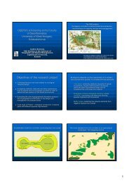
EXPERIENCE<br />
Based on the evaluation of historical monuments in the area of BIHOR county , the<br />
University Of Oradea – Faculty of Architecture and Construction initiated multiple<br />
projects regarding the documentation, promotion and conservation of historical<br />
monuments within the area. The projects were implemented in co-operation with<br />
municipalities and other regional authorities in the region of Bihor.<br />
Bihor County has more than 500 classified monuments, but the most vulnerable<br />
monuments are those located in rural areas therefore the specialists from the university<br />
choose to document and study the wooden churches.<br />
The wooden churches from Bihor are forming a valuable patrimony both at national and<br />
at international level. In Romania are still preserved 1200 wooden churches built before<br />
2<br />
Nyugat-Magyarországi Egyetem, Geoinformatikai Kar, Székesfehérvár, 2010.
Droj Gabriela: <strong>Cultural</strong> <strong>Heritage</strong> <strong>Conservation</strong> <strong>by</strong> <strong>GIS</strong><br />
Társadalom – térinformatika – kataszter * <strong>GIS</strong>open konferencia<br />
1900, from which 60 of them are located in the Bihor County. Unfortunately the local<br />
communities are not aware about the real treasure that they detain. Therefore, today,<br />
most of the wooden churches are abandoned, either because the financial cost of the<br />
rehabilitation of these churches are higher than the community affords, or in some cases<br />
there is a relative lack of interest regarding the condition of the wooden churches. In<br />
some other cases, in wealthy communities, sometimes it appeared a tendency towards<br />
abandoning the old wooden church, which is a historical monument, in order to build a<br />
new bigger church, most of the time without any artistic and cultural value.<br />
Figure 1- Wooden Churches in Bihor<br />
In the XX-nth century the number of the wooden churches in Bihor County decreased<br />
year <strong>by</strong> year. If in 1931 were 150 wooden churches, in 1970 were 73 and today only 60<br />
wooden remained. In the basin of Criul Repede river 15 wooden churches are<br />
declared and classified as monuments.<br />
Documentation, conservation and promotion of historical monuments like the wooden<br />
churches are becoming inevitable and it must be done quickly. Therefore the first area<br />
studied was the hydrographical basin of Criul Repede river, in the project called:<br />
”Valorificarea Patrimoniului <strong>Cultural</strong> Popular – Biserici De Lemn In Bihor”, financed<br />
<strong>by</strong> EEA GRANTS.<br />
3<br />
Nyugat-Magyarországi Egyetem, Geoinformatikai Kar, Székesfehérvár, 2010.
Droj Gabriela: <strong>Cultural</strong> <strong>Heritage</strong> <strong>Conservation</strong> <strong>by</strong> <strong>GIS</strong><br />
Társadalom – térinformatika – kataszter * <strong>GIS</strong>open konferencia<br />
In order to preserve, to document and to preserve the wooden churches from Bihor<br />
County the research team from the University of Oradea and internship students tried to<br />
collect valuable data of the history of the region and about the cultural landscape and<br />
about architectural monuments from different institutions.<br />
Figure 2 Wooden Churches in Crișul River Basin<br />
The information collected was:<br />
• Identification of the monument:<br />
o Topological location,<br />
o Plan metric sketch of the monument,<br />
o Documentation through images and inventory of furniture, paintings, so<br />
on<br />
o 3D Model if was possible<br />
• Time evolution of the monument:<br />
o Historical and archive data about the monuments,<br />
o Characteristics of the monument: builder, when and where was build,<br />
architectural style,<br />
o Owners<br />
o Constructive intervention on the monument<br />
• Recommendations regarding further intervention on the monument<br />
There are different techniques in order to realize a 3D model for the cultural heritage<br />
monuments. The team researchers from the University of Oradea used two different<br />
techniques: Photogrammetric model and laser scan model. In the following images there<br />
are presented a 3D model of a new wooden church obtained with laser scan (figure 3a)<br />
and in figure 3b, we presented a tridimensional model of the Saint Ladislau church from<br />
Oradea.<br />
4<br />
Nyugat-Magyarországi Egyetem, Geoinformatikai Kar, Székesfehérvár, 2010.
Droj Gabriela: <strong>Cultural</strong> <strong>Heritage</strong> <strong>Conservation</strong> <strong>by</strong> <strong>GIS</strong><br />
Társadalom – térinformatika – kataszter * <strong>GIS</strong>open konferencia<br />
a) b)<br />
Figure 3 - 3D models<br />
Within this project, for the churches studied it was impossible to use these two methods<br />
because of the vegetation and of the buildings which are surrounding the monuments.<br />
Therefore the 3D model of the churches was made from the points measured with total<br />
station, <strong>by</strong> using AutoCAD.<br />
Figure 4 - 3d model for the Hinchiris wooden church<br />
5<br />
Nyugat-Magyarországi Egyetem, Geoinformatikai Kar, Székesfehérvár, 2010.
Droj Gabriela: <strong>Cultural</strong> <strong>Heritage</strong> <strong>Conservation</strong> <strong>by</strong> <strong>GIS</strong><br />
Társadalom – térinformatika – kataszter * <strong>GIS</strong>open konferencia<br />
CONCLUSIONS<br />
Usage of <strong>GIS</strong> for the documentation of the cultural heritage of Bihor County should be<br />
useful also for the development of economy and tourism. Beyond that further usage<br />
should be considered in preservation of monument and historic buildings, in different<br />
planning procedures, in local history and education.<br />
The researchers from the University of Oradea initiated a new project” Promovarea<br />
Bisericilor De Lemn Din Ţara Beiuşului Şi Specializarea Resurselor Umane Implicate În<br />
Domeniul Conservării Şi Promovării Patrimoniului <strong>Cultural</strong>, Din Cadrul Comunităţilor<br />
Locale” financed <strong>by</strong> EEA GRANTS to expand the first project to the Beiuș Region. Also<br />
the university of Oradea wish to initiate a new project in order to create a 3D <strong>GIS</strong> map of<br />
the monuments in Bihor County.<br />
REFERENCES<br />
1. Feng Mao, Ze Liu, Wensheng Zhou, Jianxi Huang, Qiang Li - The Research<br />
And Application Of Spatial Information Technology In <strong>Cultural</strong> <strong>Heritage</strong><br />
<strong>Conservation</strong>— Case Study On Grand Canal Of China, The International<br />
Archives of the Photogrammetry, Remote Sensing and Spatial Information<br />
Sciences. Vol. XXXVII. Part B5. Beijing 2008<br />
2. Fetea, I. - Metode fotogrametrice pentru reconstrucţia monumentelor<br />
arhitecturale, Editura Durans 2010<br />
3. K. Hosse, M. Schilcher – Temporal <strong>GIS</strong> for analysis and visualisation of cultural<br />
heritage, Institute of Geodesy, <strong>GIS</strong> and Land Management, Techn. University of<br />
Munich<br />
4. Szabo, A., Droj, G. - Biserici de lemn în Bihor – Bazinul Crişul Repede, Editura<br />
Durans 2010<br />
5. Suba St., Buda A., Nistor S., Suba N. - Utilizarea scanării laser in lucrari de<br />
documentare a monumentelor arhitecturale, Editura Durans 2010<br />
CONTACTS<br />
Lect.. Dr. Gabriela Droj<br />
University of Oradea<br />
Faculty Architecture and Construction<br />
Oradea<br />
Street B. ST. Delavrancea nr 4<br />
Tel/fax. +40 259 246 705<br />
Email: ga<strong>by</strong>@oradea.ro, g_a<strong>by</strong>g@yahoo.com<br />
WWW: http://arhicon.uoradea.ro<br />
6<br />
Nyugat-Magyarországi Egyetem, Geoinformatikai Kar, Székesfehérvár, 2010.