UNIVERSITY OF WEST HUNGARY Main ... - NymE GEO portál
UNIVERSITY OF WEST HUNGARY Main ... - NymE GEO portál
UNIVERSITY OF WEST HUNGARY Main ... - NymE GEO portál
Create successful ePaper yourself
Turn your PDF publications into a flip-book with our unique Google optimized e-Paper software.
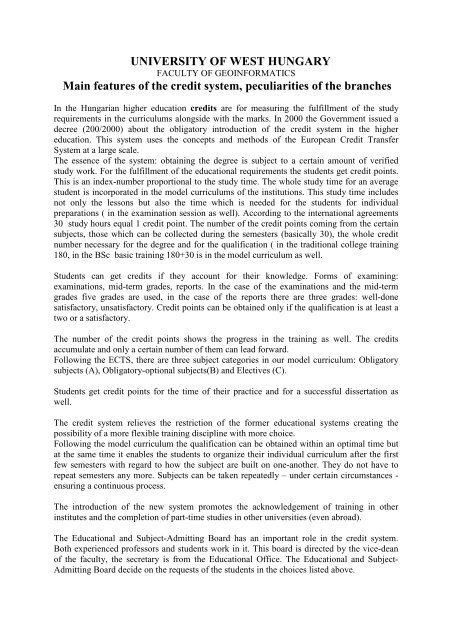
<strong>UNIVERSITY</strong> <strong>OF</strong> <strong>WEST</strong> <strong>HUNGARY</strong><br />
FACULTY <strong>OF</strong> <strong>GEO</strong>INFORMATICS<br />
<strong>Main</strong> features of the credit system, peculiarities of the branches<br />
In the Hungarian higher education credits are for measuring the fulfillment of the study<br />
requirements in the curriculums alongside with the marks. In 2000 the Government issued a<br />
decree (200/2000) about the obligatory introduction of the credit system in the higher<br />
education. This system uses the concepts and methods of the European Credit Transfer<br />
System at a large scale.<br />
The essence of the system: obtaining the degree is subject to a certain amount of verified<br />
study work. For the fulfillment of the educational requirements the students get credit points.<br />
This is an index-number proportional to the study time. The whole study time for an average<br />
student is incorporated in the model curriculums of the institutions. This study time includes<br />
not only the lessons but also the time which is needed for the students for individual<br />
preparations ( in the examination session as well). According to the international agreements<br />
30 study hours equal 1 credit point. The number of the credit points coming from the certain<br />
subjects, those which can be collected during the semesters (basically 30), the whole credit<br />
number necessary for the degree and for the qualification ( in the traditional college training<br />
180, in the BSc basic training 180+30 is in the model curriculum as well.<br />
Students can get credits if they account for their knowledge. Forms of examining:<br />
examinations, mid-term grades, reports. In the case of the examinations and the mid-term<br />
grades five grades are used, in the case of the reports there are three grades: well-done<br />
satisfactory, unsatisfactory. Credit points can be obtained only if the qualification is at least a<br />
two or a satisfactory.<br />
The number of the credit points shows the progress in the training as well. The credits<br />
accumulate and only a certain number of them can lead forward.<br />
Following the ECTS, there are three subject categories in our model curriculum: Obligatory<br />
subjects (A), Obligatory-optional subjects(B) and Electives (C).<br />
Students get credit points for the time of their practice and for a successful dissertation as<br />
well.<br />
The credit system relieves the restriction of the former educational systems creating the<br />
possibility of a more flexible training discipline with more choice.<br />
Following the model curriculum the qualification can be obtained within an optimal time but<br />
at the same time it enables the students to organize their individual curriculum after the first<br />
few semesters with regard to how the subject are built on one-another. They do not have to<br />
repeat semesters any more. Subjects can be taken repeatedly – under certain circumstances -<br />
ensuring a continuous process.<br />
The introduction of the new system promotes the acknowledgement of training in other<br />
institutes and the completion of part-time studies in other universities (even abroad).<br />
The Educational and Subject-Admitting Board has an important role in the credit system.<br />
Both experienced professors and students work in it. This board is directed by the vice-dean<br />
of the faculty, the secretary is from the Educational Office. The Educational and Subject-<br />
Admitting Board decide on the requests of the students in the choices listed above.
Study programmes:<br />
Land Surveying and Land management Specialization (BSc)<br />
Head of Specialization: Prof. Dr. Béla Márkus professor (mb@tgeo.info.hu)<br />
Consultant Committee: Education Committee<br />
Educational goal: Training of engineers for land management, within this for national survey<br />
and for map-making, who are able to do the basic land surveying jobs, familiar with the up-todate<br />
equipment, the measuring and the adaptation procedures, take part in environment<br />
protection and hazard prevention projects and are willing to broaden their knowledge in<br />
organized or self-supported courses.<br />
Specialists with a land surveyor diploma are able to solve the geodetic problems below:<br />
• Basic land surveying jobs (determination of control points, large-scale maps, making<br />
and renewing of topographic maps);<br />
• Preparing precise and detailed measurements for all kinds of technical jobs in<br />
economy with modern methods;<br />
• Preparing of land surveying, geoinformation, remote sensing documents for the<br />
development of towns, villages, industrial estates and other industrial establishments.<br />
• Planning and designing the land survey as part of the national administration;<br />
Structure of Training:<br />
Training time: 7 semesters<br />
Minimum number of lessons for full-time: 2700 hours +600 hours practicals, 600 hours +<br />
practicals for correspondent courses<br />
Obtainable credit points: minimum 210<br />
Level of degree: college degree (BSc)<br />
Specialization: land surveying engineer specialized in land management or in geoinformatics<br />
or in land cadastre<br />
Forms of Education: full-time, correspondent courses<br />
Educational and Examinational Requirements:<br />
System of knowledge tests:<br />
Compulsory examinations are: 31<br />
Marks within the semesters: 7-10 resp.<br />
Coverage: 7-9 resp.<br />
Session examinations: 0<br />
Rules for finding educational averages: weighted educational average
Contents of Course<br />
Subject - Fields United credit Rate within the<br />
points<br />
educational activity, %<br />
Natural-scientific and engineering studies<br />
Mathematics I-III., Geometry I-II, Physics,<br />
36 17,1<br />
Informatics I-II. , Environmental studies<br />
Economy and humanities<br />
Economy, State and jurisprudential studies,<br />
Communication, Organization and Management<br />
Professional subjects:<br />
Mapping, Geodesy I-II, Basics of engineering I_II.,<br />
13 6,2<br />
75 35,7<br />
System organization, Projections, Photogrammetry<br />
I-II., Geoinformatics I-II., Adjustment, Control<br />
point networks, Topography, Land registry, Large<br />
scale mapping I_II., Land use and environmental<br />
protection<br />
Differential professional Studies<br />
31 14,8<br />
Specialization in Geoinformatics: Precision<br />
geodesy, GPS, GIS applications, Project week I-II.,<br />
Engineering Surveying, GIS Management, Remote<br />
Sensing, Cartography<br />
Specialization in Land Management: Engineering<br />
Surveying , GIS applications , Photointerpretation<br />
and remote Sensing, Project week I-II., land and<br />
urban management I-II., Organization and<br />
management 2., Urban studies, Rural and urban<br />
development<br />
Specialization in land cadastre: Land registry II.,<br />
Studies in civil law, Estate development, utilization<br />
of estates I-II., Estate law I-II., Land and urban<br />
management I-II., Administrative law, , land and<br />
estate evaluation, Agrarian law<br />
Optional subjects 10 4,8<br />
Practical studies (2x3, 1x1 weeks institutional 30 14,3<br />
practice and 7 weeks workshop practice)<br />
Thesis 15 7,1<br />
Altogether 210 100%<br />
Language classes<br />
4 hours/week<br />
during 4<br />
semesters
Description of courses offered in English:<br />
PhD Program in Geoinformatics<br />
The head of the Doctoral Program is Prof. Dr. Béla Márkus.<br />
The students graduated (MSc) from UWH, Faculty of Forestry in forestry environmental<br />
protection and wildlife management are first among the candidates. Moreover, the<br />
accreditation of MSc specialisations in Land consolidation and Geoinformatics is in progress<br />
as well.<br />
In addition anybody can enrol in the doctoral program who has a university degree or has a<br />
lecturer diploma in forestry, wildlife management, GIS, remote sensing, photogrammetry,<br />
geodesy, land surveying and management, environmental studies, geography and mapping,<br />
and their prequalification enables them to carry on scientific activity.<br />
It is an advantage at the entrance examination if the candidate has a professional postgraduate<br />
diploma or complementary knowledge as an engineer-teacher.<br />
The aim of the PhD is to advance knowledge and the application of knowledge through the<br />
preparation of a substantial thesis which represents a significant contribution to a particular<br />
field of study in geoinformation sciences. It can be connected to numerous special research<br />
tasks and it can contribute to the complexity of research and spatial analysis.<br />
The Program accepts students in doctoral degrees by research in a large range of<br />
Geoinformatics related discipline areas including:<br />
Environmental studies,<br />
Forestry,<br />
Geodesy,<br />
Geography,<br />
GI Science,<br />
Land management,<br />
Land surveying,<br />
Mapping,<br />
Photogrammetry,<br />
Remote sensing,<br />
Spatial planning,<br />
Surveying,<br />
Wildlife management.<br />
Besides this anybody can enrol in the doctoral program who has an MSc degree and whose<br />
prequalification enables them to carry on scientific activities on the basis of professional<br />
experience or published research work.<br />
The doctoral degree can be attained by attending a university educational training as a regular,<br />
evening extension course PhD student or by an individual teaching program.<br />
The duration of the training is 3 years, 36 months. The PhD students should collect at least<br />
180 credit points during this period.<br />
The program has compulsory subjects (5 credits/subject) and elective/optional subjects (4<br />
credits/subject).
Compulsory subjects (5 credits each)<br />
1. Applied mathematics (Dr. Horváth Jenı)<br />
2. Informatics (Dr. Gál János)<br />
3. Planning and evaluation of experiments (Dr. Horváth-Szováti Erika)<br />
Elective subjects (4 credits each)<br />
1. Geomathematics (Dr. Závoti József)<br />
2. Modeling of spatial processes (Dr. Márkus Béla)<br />
3. Systems and standards of Geoinformatics (Dr. Mihály Szabolcs)<br />
Optional subjects (4 credits each)<br />
1. Geodetic projections (Dr. Bácsatyai László)<br />
2. Algorithms in geoinformatics (Dr. Czimber Kornél)<br />
3. Strategic questions of the information society (Dr. Detrekıi Ákos)<br />
4. Land valuation,-quality increment and decrement (Dr. Dömsödi János)<br />
5. Land use, landscape use (Dr. Dömsödi János)<br />
6. New technologies in the digital photogrammetry (Dr. Jancsó Tamás)<br />
7. Digital image processing in geoinformatics (Dr. Kalmár János)<br />
8. Land law, environmental law, law in environmental protection, water law, law in land<br />
registry (Dr. Kurucz Mihály)<br />
9. National spatial registry systems in agriculture (Dr. Martinovich László)<br />
10. Digital terrain models (Dr. Márkus Béla)<br />
11. Regional climate modeling and prognostics (Dr. Mátyás Csaba)<br />
12. Digital topography (Dr. Mélykúti Gábor)<br />
13. Global and local geodynamics (Dr. Mentes Gyula)<br />
14. Methods of regional statistics (Dr. Mészáros József)<br />
15. Remote sensing and geoinformatics in the location-specified crop farming (Dr.<br />
Neményi Miklós)<br />
16. Legal questions in GIS (Dr. Osztovits András)<br />
17. Application of thematic maps based on GIS (Dr. Pıdör Andrea)<br />
18. Corporation economics (Dr. Székely Csaba)<br />
19. Rural development and environmental protection (Dr. Udvardy Péter)<br />
20. Satellite based resource exploration and its application (Verıné Dr. Wojtaszek<br />
Malgorzata)<br />
21. Engineering geodesy (Dr. Alojz Kopáčik)<br />
22. Environmental economics (Dr. Ángyán József)<br />
23. Application of GNSS systems in the environmental studies (Dr. Bányai László)<br />
24. GNSS in engineering geodesy (Dr. Borza Tibor)<br />
25. Application of GNSS with high accuracy (Dr. Kenyeres Ambrus)<br />
26. Possible applications of geoinformatics in the environmental context (Dr. Kertész<br />
Ádám)<br />
27. Land valuation (Dr. Lóczy Dénes)<br />
28. Mathematical Geodesy and Map Projections (Dr. Reiner Jäger)<br />
29. International Land Management (Dr. Reinfried Mansberger és Dr. Walter Seher)<br />
30. GIS Environmental modeling (Dr. Tamás János)<br />
31. Geoinformatics methods in environmental protection (Dr. Vekerdy Zoltán)
Short courses offered in English:<br />
University of West Hungary Faculty of Geoinformatics<br />
Course name Building Geodatabase<br />
ECTS: 3<br />
Semester: winter / summer<br />
Department: Geoinformatics<br />
Teacher: Dr. Ferenc Végsı<br />
Description: Designing of Geodatabase<br />
Spatial thinking in the practice<br />
Defining geodatabase<br />
Definig layer structure<br />
Data integration<br />
Building layer(s) by digitising<br />
Editing and cleaning feature set<br />
Filing up atrribute tables<br />
Creating own geodatabase<br />
Validation by field work<br />
Method<br />
The course based on personal contact. The first part is conducted by<br />
teacher, it’s takes about 8-10 hours. The second part is guided by<br />
teacher, but mainly based of own work of student(s). It’s takes 10-14<br />
hours. The third part (field practice) supervised by teacher, it’s takes<br />
about half a day. The used software is ArcGis ver. xxx.
University of West Hungary Faculty of Geoinformatics<br />
Course name Data Acquisition and integration<br />
ECTS: 3<br />
Semester: winter and summer<br />
Department:<br />
Teacher: Dr. Tamas Jancso, Dr. Andrea Pıdör, Dr. Verıné Wojtasek Marlgorzata,<br />
Dr. György Busics<br />
Description:<br />
The course gives an overview about the data acquisition methods and the<br />
derived products in surveying, GPS technology, laser scanning,<br />
photogrammetry and remote sensing. The students will get knowledge<br />
about the up-to-date sensors, evaluation procedures emphasizing the<br />
connection and integration between the different methods.<br />
The course is separately dealing with the problem how to integrate the<br />
gained data and products into a GI system in order to give possibility to<br />
derive secondary data from the primary data sources. Upon completion<br />
of the course the students should know:<br />
•the methods and sensors of data acquisition in surveying, GPS, laser<br />
scanning, photogrammetry and remote sensing,<br />
•the evaluation procedures and application areas of the derived products,<br />
•data integration procedure into a GI system.<br />
Method<br />
Distanc e-learning through Internet using the Blackboard system.<br />
Standards are : English language, 90 hours workload, 13 online<br />
contact lessons, supervision and exams executed by the providing GI<br />
institute.
University of West Hungary Faculty of Geoinformatics<br />
Course name Web application development<br />
ECTS: 2<br />
Semester: winter / summer<br />
Department: Department of Geoinformation Science<br />
Teacher: Laszlo Kottyan<br />
Description: In this course you will learn the advanced Web technologies, including<br />
server-side programming, accessing databases over the Internet and<br />
browser scripting. You will understand the Web standards and how the<br />
Web works. You will use tools in order to give GIS functions to a Web<br />
application.<br />
During the semester you will do exercises and built an own application.<br />
Method<br />
The course unit actually offered in a term.<br />
This is a practical course with tutoring.<br />
Assesment: at the end of the course the student is awaited to present his<br />
application.
University of West Hungary Faculty of Geoinformatics<br />
Course name Land using and environment protection<br />
ECTS: 3<br />
Semester: winter / summer<br />
Department: Geoinformatics<br />
Teacher: Katonáné Gombás Katalin<br />
Description: Aims: The studets are given knowledge about the soil set of<br />
Hungary,agriculture and nature conservation of soil using, and their<br />
connections.<br />
<strong>Main</strong> topics:<br />
• Land using in Europe, and in the Carpathians Basin<br />
• The climatic and environmental facilites of Europe<br />
• The land cultivation’s developement and the changes of the<br />
landscape<br />
• Chategories of production sites and soil types.<br />
• Plant growing and allocation systems.<br />
• Forestry.<br />
• Environment protection and nature conservation.<br />
Literature:<br />
1. Ángyán J. szerk.: Magyarország földhasználati zónarendszerének<br />
kidolgozása az EU csatlakozási tárgyalások megalapozásához,<br />
GATE Környezet-és Tájgazdálkodási Intézet kiadása, Gödöllı,1998.<br />
2. Dömsödi János_ Szalai T.: Mezıgazdasági földhasználat,egyetemi<br />
jegyzet, GATE,Gödöllı,1997.<br />
3. Katonáné Gombás K: környezet-és természetvédelem,<br />
Kézirat,NYME <strong>GEO</strong>, Jegyzetsokszorosító<br />
Részleg,Székesfehérvár,2002.<br />
4. NormannJ.G. Pounds: Európa történeti földrajza, Osiris Kiadó,<br />
Budapest,1990.<br />
5. Nyíri L. szerk.: Földmőveleéstan. Mezıgazdasági Kiadó<br />
Budapest,1993.<br />
6. Rakonczay Z: Természetvédelem, Mezıgazdasági Szaktudás<br />
7. Kiadó, Budapest, 1995.<br />
Method<br />
Project based learning. Students have to know the basic ideas of the<br />
topics and their applications on their field.
University of West Hungary Faculty of Geoinformatics<br />
Course name Spatial Databases by Open Standards and Softwares<br />
ECTS: 3<br />
Semester: winter and summer<br />
Department: Department of Geoinformation Science<br />
Teacher: NAGY, Gábor<br />
Description: Relational databases and Database Systems<br />
Structured Query Language (SQL)<br />
OGC Simple Features – SQL (OGC Standard)<br />
PostgreSQL and PostGIS sofwares<br />
Queries with Spatial Functions and Operators<br />
Using PostGIS Databases from desktop GIS softwares<br />
Method<br />
The theory learn by digital sources (standards, program<br />
documentations, etc.) and personal or remote meetings.<br />
We use the related programs in the computer labs of the Faculty, but<br />
the students could use this programs in theirs own computer.
University of West Hungary Faculty of Geoinformatics<br />
Course name Spatial Analysis<br />
ECTS: 4<br />
Semester: winter / summer<br />
Department: Geoinformatics<br />
Teacher: Prof. Dr. Béla Márkus<br />
Description: Aims: The basic principles, algorithms and computational methods in<br />
Geographical Information Science will be introduced. The students will<br />
be able to explain the strategy, theory and rules of data analysis, to use<br />
GIS as a tool in the practice, to handle data errors in processing data and<br />
visualizing information. The subject additionally will give an overview<br />
of GIS planning and implementation using a project-based educational<br />
approach.<br />
<strong>Main</strong> topics: Fundamentals of spatial analysis. Simple spatial operations:<br />
distance and area calculations, spatial queries, statistical methods.<br />
Transformations: vector-raster, raster-vector. Neighbourhood functions:<br />
buffer generation, grouping, filtering.<br />
Multiple spatial operations: vector and raster overlay, Boolean and<br />
arithmetic operations, map algebra, spatial filtering.<br />
Digital elevation models and modelling. Spatial interpolation methods:<br />
basic, elementary and complex functions. Surface analysis. Catchment<br />
delineation.<br />
Network analysis: location and allocation.<br />
Spatial decision making. Examples. Cartographic modelling. General<br />
steps involved in traditional approach, Assumptions involved with this<br />
type of analysis.<br />
Practical problems. Error handling: eliminating sliver polygons,<br />
positional and thematic accuracy, metadata, planning. Visualization.<br />
Basics of GI project management. GIS in organisations. Future of GIS.<br />
Literature:<br />
Compulsory reading:<br />
1. Core Curriculum in GIScience, NCGIA, Santa Barbara, CA, 2000,<br />
http://www.ncgia.ucsb.edu/giscc/<br />
Recommended reading:<br />
1. GIS Core Curriculum for Technical Programs, NCGIA, Santa<br />
Barbara, CA, 1998,<br />
http://www.ncgia.ucsb.edu/education/curricula/cctp/<br />
8. Longley, P.A. – Batty, M.: Advanced Spatial Analysis, ESRI Press,<br />
Redlands, CA, 2003.<br />
Method<br />
Project based learning. There are 6 module of lectures. Students should<br />
prepare 6 assignments during their study. Software: ArcGIS 9. In the<br />
computer lab students are working on their own, and advised by the<br />
teacher if needed.
University of West Hungary Faculty of Geoinformatics<br />
Course name Geoinformation management<br />
ECTS: 2<br />
Semester: winter / summer<br />
Department: Geoinformatics<br />
Teacher: Prof. Dr. Béla Márkus<br />
Description: Aims: The basic principles, methods and some practical tools in<br />
Geographical Information Management are introduced. The subject also<br />
dealing with GIS planning and implementation. Special emphasis is<br />
given to the introduction of team-work skills.<br />
<strong>Main</strong> topics: Fundamentals of Information Management, strategic<br />
planning, basic elements of systems and influence of the environment.<br />
Basics of GIS project management, project initiation, user needs<br />
analysis, user oriented project planning and documentation, logical<br />
framework matrix, Gantt-diagram, cost-benefit analysis, datainformation<br />
matrix, proposals, total quality management, change<br />
management, marketing and monitoring. Process and milestones of GIS<br />
implementation from tendering to benchmarking, piloting and<br />
continuous operation. GIS in organisations. Future of GIS.<br />
Literature:<br />
Compulsory reading:<br />
9. Frank A. - Raubal M. - van der Vlugt M.: PANEL - GI<br />
Compendium, Geoinfo Series nr. 21, Vienna, 2000.<br />
Recommended readings:<br />
1. Tomlinson, R: Thinking about GIS, ESRI Press, Redlands,<br />
California, 2003.<br />
2. BEST-GIS: Guidelines for best practice in user interface for GIS,<br />
Genoa, Italy, 1998.<br />
3. Calkins H. et al.: Geographic Information System Development<br />
Guides, NCGIA CC, Unit 136.<br />
4. Nebraska Guidebook for a Local Government Multipurpose Land<br />
Information System,<br />
http://www.calmit.unl.edu/gis/LIS_Stds_Intro.html, 2000.<br />
5. NCGIA Core Curriculum, Volume 3, SE FFFK, Székesfehérvár,<br />
1994.<br />
Method<br />
Project based learning. Students should prepare step-by-step a GI project<br />
proposal and submit at the end of the study. Each step involves a written<br />
assignment and an oral presentation, both advised by the teacher.
University of West Hungary Faculty of Geoinformatics<br />
Course name The Practice Real Estate Valuation<br />
ECTS: 4<br />
Semester: winter / summer<br />
Department: Geoinformatics<br />
Teacher: Mizseiné Dr. Nyíri Judit<br />
Description: Aims: The objective of this module is to give an overview on products<br />
and services of real estate market. On completion of this module students<br />
can gain knowledge on real estate marketing including market research<br />
and market analysis. These skills help the appraiser determine the real<br />
value of different kinds of properties. Aim of the subject is to give<br />
knowledge to students about the agricultural land evaluation. The<br />
students get detailed knowledge about the arable land evaluation and<br />
about the compensation.<br />
<strong>Main</strong> topics: The objective of this module is to give an overview on<br />
products and services of real estate market. On completion of this<br />
module students can gain knowledge on real estate marketing including<br />
market research and market analysis. These skills help the appraiser<br />
determine the real value of different kinds of properties. Aim of the<br />
subject is to give knowledge to students about the agricultural land<br />
evaluation. The students get detailed knowledge about the arable land<br />
evaluation and about the compensation.<br />
Literature:<br />
1. Mizseiné Nyiri Judit (1999): Földminısítés és értékbecslés II.<br />
(Ingatlan-értékbecslés), Ingatlankataszteri Szakmérnöki továbbképzés<br />
jegyzete, SE FFFK, Székesfehérvár.<br />
2. Hajnal I. (1995, 1999): Az ingatlan értékelés Magyarországon,<br />
BME Mérnöktovábbképzı Intézet, Budapest.<br />
3. TEGOV<strong>OF</strong>A: Útmutató az állóeszközök értékeléséhez.<br />
(Fordítás), FÜTI OMEGA KFt.-Proconsult, Budapest. (1994).<br />
4. Dr.Hajnal István: Ingatlanfejlesztés Magyarországon, Budapest,<br />
2000 (BME Mérnöktovábbképzı Intézet<br />
5. Land valuation<br />
Method<br />
Land evaluation as a concept, practical questions Current situation and<br />
development of land and estate evaluation, natural resources and their<br />
role in evaluation, European methods, EVS (European Valuation<br />
Standard), real estate register of municipalities, legal background of<br />
evaluation, Mathematical background of evaluation, evaluation methods,<br />
European methods of evaluation.


