E-Terra – the implementation stages of the new cadastral system in ...
E-Terra – the implementation stages of the new cadastral system in ...
E-Terra – the implementation stages of the new cadastral system in ...

Create successful ePaper yourself
Turn your PDF publications into a flip-book with our unique Google optimized e-Paper software.
E-TERRA <strong>–</strong> <strong>the</strong> <strong>implementation</strong> <strong>stages</strong> <strong>of</strong> <strong>the</strong> <strong>new</strong> <strong>cadastral</strong> <strong>system</strong> <strong>in</strong> Romania<br />
Carmen GRECEA, Sor<strong>in</strong> Ioan HERBAN, Cosm<strong>in</strong> Constant<strong>in</strong> MUŞAT, Al<strong>in</strong>a Cor<strong>in</strong>a BĂLĂ,<br />
_________________________________________________________________________________________<br />
Legal challenges <strong>–</strong> IT responses * GISopen Conference 2013<br />
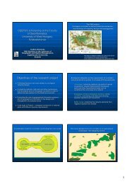
It can be seen that <strong>the</strong> Timis County is <strong>in</strong>cluded <strong>in</strong> Group 1, and <strong>the</strong> adm<strong>in</strong>istrative-territorial<br />
unit for which <strong>the</strong> general cadaster project started is: <strong>the</strong> commune Orţişoara. Data and<br />
<strong>in</strong>formation will be provided to <strong>the</strong> contractor only for this particular objective, i.e.: only with<br />
<strong>the</strong> purpose to do this particular work.<br />
Figure 2 <strong>–</strong> Pilot Project to be implemented <strong>in</strong> various counties<br />
3.THE USE OF CADGEN APPLICATION TO CHECK THE CADASTRAL DATA<br />
USED BY ANCPI<br />
The DESKTOP CADGEN application is part <strong>of</strong> <strong>the</strong> <strong>in</strong>formatic <strong>in</strong>strument package used to<br />
transfer data from <strong>the</strong> General Cadastre <strong>in</strong>to <strong>the</strong> <strong>in</strong>tegrated <strong>system</strong> <strong>of</strong> Cadastre and Land<br />
Register e-<strong>Terra</strong>.<br />
The ma<strong>in</strong> objectives <strong>of</strong> <strong>the</strong> DESKTOP CADGEN application are:<br />
to make efficient and to automate <strong>the</strong> process to validation/check files .cgxml,<br />
with <strong>cadastral</strong> data and land registry data, follw<strong>in</strong>g <strong>the</strong> General Cadastre works;<br />
to standardize <strong>the</strong> work<strong>in</strong>g documents: standard forms <strong>of</strong> <strong>in</strong>formation sheets with<br />
<strong>cadastral</strong> data (extracted from e-<strong>Terra</strong> and sent to e-<strong>Terra</strong>);<br />
to secure <strong>in</strong>formation;<br />
to follow <strong>the</strong> events <strong>in</strong> <strong>the</strong> <strong>system</strong>;<br />
„Data validation CAD” is <strong>the</strong> functionality to check data <strong>in</strong> <strong>the</strong> reception stratum by <strong>the</strong><br />
technical Validator ANCPI.<br />
4<br />
University <strong>of</strong> West Hungary, Faculty <strong>of</strong> Geo<strong>in</strong>formatics, Szekesfehervar, Hungary, 12-14 March 2013