Marine Ecosystems Research Department - jamstec japan agency ...
Marine Ecosystems Research Department - jamstec japan agency ...
Marine Ecosystems Research Department - jamstec japan agency ...

You also want an ePaper? Increase the reach of your titles
YUMPU automatically turns print PDFs into web optimized ePapers that Google loves.
Japan <strong>Marine</strong> Science and Technology Center<br />
Institute for Frontier <strong>Research</strong> on Earth Evolution (IFREE)<br />
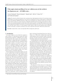
Fig.17 Subducted ridge imaged from multi-channel seismic data at the Kumano-nada.<br />
mated to be a maximum of ~.km high, ~-km<br />
wide, and ~km long. Spatial mapping of the ridge<br />
shows that it is located roughly at the seaward edge of<br />
the coseismic rupture zone of the Tonankai<br />
earthquake (M = .). This ridge appears to be in close<br />
contact with the seaward end of the rigid backstop of<br />
the Tonankai segment, and is located exactly beneath<br />
the backstop of the Tokai segment. These spatial correlations<br />
and the ridge-backstop collision geometry<br />
suggest that the subducted ridge might be strongly<br />
mechanically coupled and may thus play a significant<br />
role as a seaward barrier inhibiting the earthquake<br />
rupture from propagating farther seaward. We<br />
propose that possible differential mechanical coupling<br />
caused by the heterogeneous ridge-backstop collision<br />
might help to create the rupture segmentation of the<br />
eastern Nankai subduction zone.<br />
We also successfully imaged subducted oceanic<br />
crust beneath central Japan down to km depth by<br />
processing onshore-offshore wide-angle seismic data,<br />
which were acquired from the western edge of the Izu<br />
island arc to the coast line of the Japan Sea (Fig.).<br />
This image shows a –km high undulation at the top<br />
of the subducted oceanic crust beneath central Japan.<br />
This might indicate that the ridge subduction, mentioned<br />
above, extends even deeper. The subducted top<br />
of oceanic crust is clearly recognized as a high reflective<br />
layer. This part of the subducted crust is imaged at<br />
the same location where a high Poisson's ratio layer<br />
was obtained by a previous tomographic study. We<br />
propose that the highly reflective/high Poisson's ratio<br />
structure might be an evidence of dehydration from<br />
the subducted ridge system.<br />
(ii) Micro-seismicity and aseismic-seismogenic transition<br />
process at the subduction seismogenic zone<br />
Off cape Muroto, fault area of the Nankai<br />
earthquake, several micro earthquake clusters locate<br />
Zenisu Ridge<br />
Depth (km)<br />
0<br />
10<br />
20<br />
30<br />
40<br />
50<br />
6<br />
7<br />
4<br />
5<br />
Island arc upper crust<br />
Island arc lowe<br />
6<br />
4<br />
6<br />
3<br />
2<br />
7<br />
Paleo Zenisu - north ridge<br />
-<br />
Zenisu - south ridge e-<br />
Subducted ridge<br />
Subducted<br />
beneath central Japan ?<br />
oceanic crust<br />
1.5 2.5 3.5 4.5 5.5 6.5 7.5 8.5<br />
0 50 100 150 200 250 300 350 400 450<br />
Distance (km)<br />
Fig.18 Seismic velocity image crossing the central Japan obtained from onshore-offshore seismic integrated seismic<br />
survey. Lighter colored region indicates where no seismic ray sampled.<br />
99