Marine Ecosystems Research Department - jamstec japan agency ...
Marine Ecosystems Research Department - jamstec japan agency ...
Marine Ecosystems Research Department - jamstec japan agency ...

Create successful ePaper yourself
Turn your PDF publications into a flip-book with our unique Google optimized e-Paper software.
JAMSTEC 2002 Annual Report<br />
Deep Sea <strong>Research</strong> <strong>Department</strong><br />
(a)<br />
(b)<br />
Time (ms)<br />
700<br />
710<br />
720<br />
730<br />
740<br />
750<br />
760<br />
770<br />
780<br />
790<br />
800<br />
810<br />
820<br />
830<br />
840<br />
850<br />
860<br />
870<br />
880<br />
890<br />
900<br />
910<br />
920<br />
930<br />
940<br />
950<br />
960<br />
970<br />
980<br />
990<br />
1000<br />
1010<br />
1020<br />
1030<br />
1040<br />
1050<br />
1060<br />
1070<br />
1080<br />
1090<br />
1100<br />
1110<br />
1120<br />
1130<br />
1140<br />
1150<br />
1160<br />
1170<br />
1180<br />
1190<br />
1200<br />
1210<br />
1220<br />
1230<br />
1240<br />
1250<br />
1260<br />
1270<br />
1280<br />
1290<br />
1300<br />
Calyptogena colony<br />
carbonate crust<br />
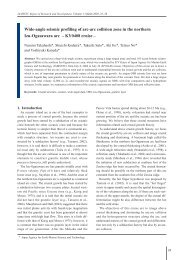
Fig. 1 (a) A single-channel seismic profile on the top of<br />
the Kuroshima Knoll. Reverse polarity and lowvelocity<br />
zone are recognized beneath the methane<br />
seep sites. Blue lines and brown lines are interpreted<br />
as faults and layer boundaries, respectively.<br />
Inset shows the area map of the Kuroshima Knoll.<br />
(b) A CAT meter installed on a Calyptogena colony.<br />
gathered data included geological data regarding the<br />
landslide from Mauna Loa. An intensive survey of<br />
submarine ridges formed by magma intrusions was<br />
made along the Hana Ridge (Haleakala east rift zone)<br />
extending km from the Haleakala volcano of Maui<br />
as well as at Puna Ridge from Kilauea and at Hilo<br />
Ridge from Mauna Kea. The change in chemical components<br />
of the magma bodies among the volcanoes<br />
and the ridges suggests that the magma source<br />
changes as the volcano passes over the plume.<br />
and passive sources (airguns and earthquakes). R/V M.<br />
Ewing surveyed the area around ˚N using MCS and<br />
OBS for crustal scale investigation. R/V Kaiyo<br />
employed OBSs to shoot a transect along ˚N<br />
25 00'<br />
24 30'<br />
24 00'<br />
23 30'<br />
23 00'<br />
22 30'<br />
22 00'<br />
21 30'<br />
c) Seismo-electromagnetic surveys of the Mariana<br />
Arc system<br />
The Izu-Ogasawara-Mariana arc system is an oceanic<br />
arc system extending more than km from central<br />
Japan southward forming the eastern edge of the<br />
Philippine Sea. The structure of the trench-arc-backarc<br />
system provides important information about the<br />
formation and evolution history of the system as well<br />
as its dynamics and mass and energy transfer budgets.<br />
Among various cruises made to the area for marine<br />
geological and geophysical investigations, we highlight<br />
the ongoing Japan-U.S. collaborative study using<br />
multi-channel seismics and ocean bottom seismographs<br />
(short period and wide-band types) for active<br />
21 00'<br />
20 30'<br />
20 00'<br />
19 30'<br />
19 00'<br />
18 30'<br />
18 00'<br />
17 30'<br />
17 00'<br />
200 00'<br />
201 00' 202 00' 203 00' 204 00' 205 00' 206 00' 207 00'<br />
-5000 -4000 -3000 -2000 -1000<br />
-6000 -5500 -4500 -3500 -2500 -1500 -500<br />
BATHYMETRY<br />
Fig. 2 Bathymetric map in the underwater area of the Hawaiian<br />
Island. JAMSTEC leads a four-year (1998, 1999, 2001, and<br />
2003) Japan-USA collaborative survey of the underwater<br />
flank of the Hawaiian volcanoes. This exploration utilized<br />
manned and un-manned submersibles, dredge and pistoncorer<br />
to sample, and ship-based sonar systems to map the<br />
bathymetry from the seafloor. The resulting swaths reveal<br />
the seafloor in stunning detail.<br />
m<br />
20