BLAST DESIGN - geo-konzept GmbH
BLAST DESIGN - geo-konzept GmbH
BLAST DESIGN - geo-konzept GmbH

Create successful ePaper yourself
Turn your PDF publications into a flip-book with our unique Google optimized e-Paper software.
Blast design<br />
GPS - surveying in mining<br />
Task<br />
The 3D measuring of a rockface (e.g. with the Pulsar 3D FastScan profiler) is a very quick and easy way to<br />
produce an accurate 3D model of the blast area. This 3D model supports planning a safe and efficient blast.<br />
In the same way, the complexity of a blast is growing and the whole blast pattern gets more and more difficult.<br />
Furthermore, the 3D scan only shows the rockface and not the upper floor, which is the start point for<br />
the blastholes. If the hole top deviates from its planned position, it is possible, that the actual Z-level of the<br />
drilled blasthole changes too. This may cause a false hole depth.<br />
Solution<br />
For a more efficient staking-out of blast patterns and a more accurate planning, <strong>geo</strong>-<strong>konzept</strong> <strong>GmbH</strong> developed<br />
the QuarryPocket GPS software. By using coordinates, calculated by the GNSS receiver, the software<br />
leads the user to the planned collar. A constant control of the coordinates and quality parameters guarantees<br />
highest accuracy and safety.
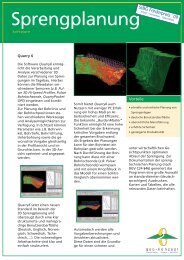
Blast Design<br />
integrated workflow<br />
After recording the 3D-model of the rockface with<br />
the laser scanner, the blast pattern is planned in the<br />
QuarryX software. The calculated coordinates for the<br />
collars are transferred to the GNSS-system. Afterwards<br />
the points can be staked out by using the<br />
QuarryPocket GPS module. During the staking-out<br />
of the drilling positions the measured coordinates are<br />
recorded and subsequently transferred to the<br />
QuarryX software. Now, the actual blasthole positions<br />
serve for calculating the exact drilling depths.<br />
Pulsar 3D<br />
Laserscanner<br />
GNSS-system<br />
„QuarryX“<br />
Software<br />
safe and efficient blast<br />
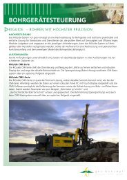
Drill Rig Guidance System RiGuide<br />
Based on 3D-laserscanning data <strong>geo</strong>-<strong>konzept</strong>s<br />
blastdesign software QuarryX allows the user to<br />
design safe and efficient blasts. To transfer the designed<br />
holepositions and parameters to your bench,<br />
<strong>geo</strong>-<strong>konzept</strong> offers the GPS/GNSS based Drill Rig<br />
Guidance System RiGuide. RiGuide is an easy and<br />
practical retrofit solution for drill rigs of service providers<br />
and quarry owners. The complete blast design<br />
can be transfered via USB to the terminal on the<br />
drill rig. With it´s built in navigation functionality, the<br />
system guides the user to the planned hole positions<br />
with an accuracy of 2 cm. With this solution a<br />
manual stake out with measuring tape and spray<br />
colour is no longer required. The system also assures<br />
that drilling is accomplished according to the<br />
designed parameters, like drillangle, azimuth and<br />
holedepth.<br />
Features<br />
Easy handling<br />
Best possible planning accuracy<br />
Integrated workflow<br />
Quick and exact stake-out of complex blast patterns<br />
Modular concept<br />
<strong>geo</strong>-<strong>konzept</strong> - Gesellschaft für Umweltplanungssysteme mbH<br />
Gut Wittenfeld 85111 Adelschlag<br />
phone +49 (0) 8424 89 89 0 fax +49 (0) 8424 89 89 80<br />
<strong>geo</strong>@<strong>geo</strong>-<strong>konzept</strong>.de www.<strong>geo</strong>-<strong>konzept</strong>.de<br />
<strong>geo</strong>-<strong>konzept</strong> follows a policy of continuous product improvement; specifications and descriptions are thus subject to change without notice.All trademarks<br />
are the property of their respective owners.