Quantitative paleoenvironmental and paleoclimatic reconstruction ...
Quantitative paleoenvironmental and paleoclimatic reconstruction ...
Quantitative paleoenvironmental and paleoclimatic reconstruction ...

Create successful ePaper yourself
Turn your PDF publications into a flip-book with our unique Google optimized e-Paper software.
ARTICLE IN PRESS<br />
N.D. Sheldon, N.J. Tabor / Earth-Science Reviews xxx (2009) xxx–xxx<br />
5<br />
Kraus, 1987; Kraus, 1987; Kraus, 1997) is based on the idea that<br />
paleosol formation should be viewed in terms of the depositional<br />
processes <strong>and</strong> system that it formed in (as individual facies within the<br />
depositional system), rather than as an independent entity. Summing<br />
up their findings from the Eocene Willwood Formation briefly,<br />
paleosol maturity should increase with distance away from a fluvial<br />
channel, going from Entisol-like (Protosol) paleosols immediately<br />
adjacent to the channel to more well-developed paleosols on more<br />
distal areas of the floodplain (Bown <strong>and</strong> Kraus, 1987; Kraus <strong>and</strong> Aslan,<br />
1993; Kraus, 1997). Flood frequency (i.e., recurrence interval), flood<br />
intensity (e.g., proportion of the floodplain inundated), <strong>and</strong> rate of<br />
accommodation space creation (denudation/subsidence) are important<br />
controlling variables (Kraus, 1999). More recent applications of<br />
the pedofacies concept have found more complex maturity-floodplain<br />
position relationships (Hamer et al., 2007b), but the general concept<br />
appears widely applicable. Applications of sequence stratigraphy <strong>and</strong><br />
the pedofacies concept are particularly important in long-term<br />
<strong>paleoclimatic</strong> studies, because paleosol maturity has often been<br />
used to indicate climatic intensity (references in Retallack, 2001b;<br />
Retallack et al., 2000). While maturity <strong>and</strong> weathering intensity may<br />
indicate climatic conditions (Retallack <strong>and</strong> Germán-Heins, 1994), they<br />
could equally indicate long formation times <strong>and</strong> floodplain stability<br />
(Kraus, 1997). Cyclical changes to the depositional system are<br />
probably due to short-term climate fluctuations or to locally<br />
magnified effects based on global drivers such as Milankovitch<br />
cyclicity (e.g., Retallack et al., 2004b), <strong>and</strong> need to be taken into<br />
account when reconstructing past climatic <strong>and</strong> environmental<br />
conditions. The approach advocated by Buck <strong>and</strong> Mack (1995),<br />
Sheldon et al. (2002), Sheldon <strong>and</strong> Retallack (2004), <strong>and</strong> Sheldon<br />
(2006c) is to compare only paleosols of similar maturity <strong>and</strong> similar<br />
inferred physiographic setting (i.e., similar pedofacies) when reconstructing<br />
past climatic conditions. By confining proxy-based <strong>reconstruction</strong>s<br />
of paleo-precipitation <strong>and</strong> paleo-temperature to<br />
moderately to well-developed paleosols (Inceptisol-like to Alfisollike),<br />
those authors have reconstructed past climatic conditions that<br />
very closely match <strong>reconstruction</strong>s based on fossil floras (Sheldon<br />
et al., 2002; Sheldon <strong>and</strong> Retallack, 2004). Close consideration of data<br />
quality <strong>and</strong> recognition of alluvial stratigraphy often lead to fairly<br />
substantial differences in climatic histories (e.g., Terry, 2001 versus<br />
Retallack, 1983), so careful underst<strong>and</strong>ing of stratigraphic <strong>and</strong> facies<br />
relationships is critical.<br />
2.2. Semi-quantitative methods<br />
2.2.1. Compaction<br />
Sheldon <strong>and</strong> Retallack (2001) presented a straightforward method<br />
for evaluating the effects of compaction on paleosols <strong>and</strong> for<br />
decompacting soils to their original thickness at the time of their<br />
formation. That paper also reviewed previous attempts to make the<br />
same types of calculations from Retallack (1994) <strong>and</strong> Caudill et al.<br />
(1997), both of which mis-estimated compaction of shallowly buried<br />
paleosols, <strong>and</strong> demonstrated the issues associated with those previous<br />
methods. The decompaction method of Sheldon <strong>and</strong> Retallack (2001)<br />
can only be considered to be semi-quantitative because it relies on<br />
accurate taxonomic description of the paleosols in order to determine<br />
the correct constants to use in the generalized equation.<br />
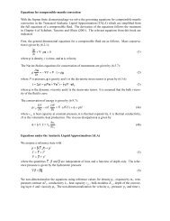
Soils <strong>and</strong> their associated sediments are compactable because they<br />
include some porosity between the individual constituent grains. How<br />
compactable a given soil or sediment type will be is a function of their<br />
solidity (the fractional complement to porosity):<br />
S i = ρ d<br />
ρ s<br />
where ρ d is the dry bulk density of the soil <strong>and</strong> ρ s is the solid grain<br />
bulk density of the material that was weathered to form the soil. For<br />
ð1Þ<br />
most soils, ρ s will be 2.5–2.9 g cm 3 , where 2.7 g cm 3 is a reasonable<br />
value for clay-rich soils (Sheldon <strong>and</strong> Retallack, 2001; Table 2). The<br />
compaction of a given soil is given by:<br />
C = S i<br />
S b<br />
where S b is the burial solidity, which should exceed S i for a material<br />
that has been compacted, thus giving Cb1. For normally pressured<br />
sections, the generalized compaction equation of Sclater <strong>and</strong> Christie<br />
(1980) may be used as a starting point:<br />
F = F 0 e − kD<br />
where F is the fractional burial porosity, F 0 is the initial porosity, D is<br />
the burial depth expressed in km, <strong>and</strong> k is an empirically derived<br />
curve-fitting constant (for equation, see Sheldon <strong>and</strong> Retallack, 2001).<br />
Because porosity is the complement of solidity (i.e., F 0 =1− S i <strong>and</strong><br />
F=1−S b ), Eq. (2) can be combined with Eq. (3) <strong>and</strong> re-arranged to<br />
give compaction (C) as follows:<br />
C =<br />
−S i<br />
h i ð4Þ<br />
F 0<br />
e kD − 1<br />
Fig. 6 depicts compactibility differences among some common soil<br />
orders with burial depth using constants for S i , F 0 , <strong>and</strong> k from Table 2.<br />
The method has been widely applied both to long sequences of<br />
paleosols (e.g., Sheldon <strong>and</strong> Retallack, 2004; Clevel<strong>and</strong> et al., 2007)<br />
<strong>and</strong> to individual paleosols for <strong>paleoclimatic</strong> (e.g., Prochnow et al.,<br />
2006; Retallack, 2007) <strong>and</strong> paleoaltimetry (e.g., Takeuchi et al., 2007)<br />
applications. In general, this method gives results that closely match<br />
independent estimates of compaction, though the results depend in<br />
part on accurate taxonomic description of the paleosols because there<br />
is a wide range in the properties of analogous modern soils (Table 2).<br />
Table 2<br />
Paleosol decompaction constants.<br />
Substrate Density Range σ S i F 0 k<br />
Marine (Sclater <strong>and</strong> Christie, 1980)<br />
Shale 1.07 – – 0.37 0.63 0.51<br />
S<strong>and</strong> 1.35 – – 0.51 0.49 0.27<br />
Chalk 0.81 – – 0.30 0.70 0.71<br />
Shaley s<strong>and</strong> 1.18 – – 0.44 0.56 0.39<br />
Soil types<br />
Alfisol (n =46) 1.68 1.33–1.97 0.16 0.65 0.35 0.15<br />
Andisol (n =26) 0.79 0.44–1.50 0.27 0.30 0.70 0.71<br />
Aridisol (n =24) 1.60 1.39–1.76 0.09 0.62 0.38 0.17<br />
Entisol (n =3) 1.61 1.60–1.64 – 0.62 0.38 0.17<br />
Histosol (n =13) 0.07 0.04–0.10 0.02 0.06 0.94 2.09<br />
Inceptisol (n =41) 1.32 0.65–1.92 0.39 0.51 0.49 0.27<br />
Mollisol (n =50) 1.42 0.85–1.91 0.25 0.55 0.45 0.23<br />
Oxisol (n =31) 1.30 0.96–1.46 0.11 0.50 0.50 0.29<br />
Spodosol (n =20) 0.97 0.30–1.87 0.47 0.37 0.63 0.52<br />
Ultisol (n =38) 1.50 0.97–1.84 0.27 0.58 0.42 0.20<br />
Vertisol (n =380) 1.80 1.55–2.06 0.16 0.69 0.31 0.12<br />
Modern floodplain (Nadon <strong>and</strong> Issler, 1997)<br />
Inorganic silts <strong>and</strong> clays<br />
Mean (Liquid limit b50) a – – – 0.635 0.365 0.16<br />
Mean (Liquid limit N50) b – – – 0.511 0.489 0.27<br />
S<strong>and</strong>s<br />
Mean c – – – 0.692 0.308 0.12<br />
Note: Units of density <strong>and</strong> range are g cm − 3 . Units on k are ×10 − 5 cm − 1 . Original<br />
sources for the paleosol data contained in the table are given in Sheldon <strong>and</strong> Retallack<br />
(2001).<br />
a Silts (n=61) <strong>and</strong> clays (n=261); porosity ranges from 35.72% to 37.34%.<br />
b Silts (n=9) <strong>and</strong> clays (n=61); porosity ranges from 46.96% to 50.80%.<br />
c Clean (graded; n=20), clean (poorly graded; n=62), silty s<strong>and</strong>s (n=153), <strong>and</strong><br />
clayey s<strong>and</strong>s (n=88); porosity ranges from 30.10% to 31.59%.<br />
ð2Þ<br />
ð3Þ<br />
Please cite this article as: Sheldon, N.D., Tabor, N.J., <strong>Quantitative</strong> <strong>paleoenvironmental</strong> <strong>and</strong> <strong>paleoclimatic</strong> <strong>reconstruction</strong> using paleosols, Earth-<br />
Science Reviews (2009), doi:10.1016/j.earscirev.2009.03.004