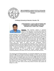
Hiranya Sahoo - Gulf Coast Section SEPM
Hiranya Sahoo - Gulf Coast Section SEPM
Hiranya Sahoo - Gulf Coast Section SEPM

You also want an ePaper? Increase the reach of your titles
YUMPU automatically turns print PDFs into web optimized ePapers that Google loves.
I received my M.Tech.<br />
(Master in technology)<br />
degree in Geo‐exploration,<br />
supported by a Schlumberger<br />
Fellowship; my thesis was<br />
entitled "A geological and<br />
geophysical analysis of seismic<br />
data attributes from the post<br />
rift stratigraphy of a North Sea<br />
3D seismic dataset". Later I joined University of New Orleans where I am currently pursuing my<br />
PhD research on "Channel‐ fill architecture and paleo‐channel morphometry of the<br />
Cretaceous Blackhawk Formation, Wasatch Plateau, Utah: Implications for improved fluvial<br />
reservoir modeling". Ongoing PhD research has been awarded 2009 ExxonMobil Geoscience<br />
Grant, 2010 Kenneth H. Crandall Memorial Grant from AAPG, 2010 Ed Picou Fellowship Grant<br />
from GCS<strong>SEPM</strong> (<strong>Gulf</strong> <strong>Coast</strong> <strong>Section</strong> <strong>SEPM</strong>), and 2010 Postgraduate Grant from IAS<br />
(International Association of Sedimentologists). I have been awarded 2010 graduate<br />
scholarship from New Orleans Geological Society.<br />
Delineating paleo‐channel morphometry of the Cretaceous Blackhawk<br />
Formation in the Western Interior Seaway: A regional‐scale approach<br />
<strong>Hiranya</strong> <strong>Sahoo</strong>, Earth and Environmental Sciences, GP 1065 , University of New Orleans, 2000 Lakeshore<br />
Drive, New Orleans, LA, 70148.<br />
Email: hsahoo@uno.edu, hiranyasahoo@gmail.com
1. PROBLEMS, AND OBJECTIVES:<br />
Firstly, some latest critical reviews on fluvial studies (e.g. Schumm, 2005; Bridge, 2006;<br />
Ethridge, 2011) indicate that modern fluvial systems (comparing to ancient counterparts)<br />
manifest a far more complex heterogeneities ranging from continuum of planform (straight to<br />
meandering to braided) along with wide sedimentologic variation (grain size, mud content,<br />
bedform) at a spatio-temporal scale grossly discordant of any particular end-member stream<br />
character, and that the range and potential of these complexities have been poorly appreciated<br />
in rock record interpretation. To bridge this inadequacy of ancient fluvial description, Ethridge<br />
(2011) categorically recommends intensive documentation of all scale-variant sedimentologic<br />
attributes from fluvial preserved strata focusing evolution of river system at spatio-temporal<br />
scale that will generate first-approximations of range of fluvial heterogeneities as reflected in<br />
modern analog studies. Secondly, recent comprehension on modern fluvial depositional<br />
systems of continental sedimentary basins (e.g. Hartley et al., 2010; Weissmann et al., 2010)<br />
reveal that they are overwhelmingly distributive in character, and thus, this standpoint invokes<br />
for similar proposition to be scrutinized in fluvial rock record which has not been well<br />
constrained so far. To explore these two specifics, the proposed study attempts a regional-scale<br />
paleohyadraulic analysis from outcrop data of coastal-plain succession in the Wasatch Plateau,<br />
Utah.
2. REGIONAL/THEMATIC CONTEXT:<br />
Wasatch Plateau of central Utah is N-S elongated, being contiguous and perpendicular to W-E<br />
oriented Book Cliffs of Utah and Colorado (Figure 1). Here, study of the Cretaceous Blackhawk<br />
Formation is topical in context that 1) it embodies c. 3.5-4.0 Myr depositional history<br />
accumulating both non-marine and marine sedimentation, and 2) it is c. 300 m thick mud- and<br />
coal-prone succession persistently been subjected to petroleum industry attention (e.g.<br />
Krystinik and Dejarnett, 1995; Adams and Bhattacharya, 2005; Hampson et al., 2011). At the<br />
length of the plateau (i.e. c. 120 km), the Blackhawk Formation superbly crops out as a coastalplain<br />
complex comprising fluvial-channel sandbodies encased within coastal-plain mudstones,<br />
in addition to numerous intervening coal seams (e.g. Flores et al., 1984).<br />
Fluvial rock record analysis of the Blackhawk Formation in the Wasatch plateau has<br />
been sparsely attempted so far, only providing localized description (at one canyon of the<br />
plateau) of marginal marine coastal-plain character at the lower part to more continental-fluvial<br />
nature at the upper part (e.g. Adams and Bhattacharya, 2005). In regard to the far-larger length<br />
of the plateau (i.e. c. 120 km), this description tends to be inadequate to fully constrain paleochannel<br />
dynamics at a regional-scale. To supplement to the paucity of outcrop documentation<br />
and their interpretation, our ongoing study focuses a comprehensive outcrop data collection<br />
from preserved fluvial strata in the entire plateau and their subsequent paleohudraulic<br />
estimation to delineate paleo-channel morphometry of the formative river at different<br />
stratigraphic interval (lower, middle and upper) of the Blackhawk Formation that will shed<br />
critical lights on the river system evolution of the Formation at a spatio-temporal scale. This<br />
evolved sedimentologic knowledge, as analogous dataset, will be paramount to evaluate,<br />
validate and calibrate modern fluvial system heterogeneities. Moreover, ongoing fluvial
characterization on a coastal-plain paleo-landscape (Figure 2) is advantageous to establish the<br />
distributive nature of formative rivers in rock record (i.e. width, depth, discharge estimates of<br />
major trunk river vis-à-vis its distributive threads) as adequately invoked by latest modern<br />
fluvial studies (e.g. Hartley et al., 2010; Weissmann et al., 2010).<br />
3. METHOD & PRELIMINARY RESULTS:<br />
The ongoing outcrop documentation is being executed with detailed spatial documentation of<br />
grain size, bedform proportion (dune-scale and ripple-scale), dune-scale cross set thickness,<br />
preserved bar height, accretion bedding dip, paleoindicators etc. Collected dataset is being<br />
employed to established paleohyadraulic computational procedures (e.g. Schumm, 1972;<br />
Leclair and Bridge, 2001; Bhattacharya and Tye, 2004) that is helping us to derive paleo-channel<br />
morphometry (channel-width, flow depth, channel-belt width and depth, discharge, sinuosity)<br />
of formative rivers flowed on this coastal-plain paleo-landscape (Figure 2). Azimuthal readings<br />
from paleocurrent indicators are being synthesized to deduce overall paleoflow pattern. At the<br />
length of the entire plateau (i.e. c. 120 km), all these derived informations are being gleaned for<br />
each unit (lower, middle and upper) of the Blackhawk Formation in order to unravel formative<br />
river characteristics with varying distance from coeval shoreline. Additionally, these evolved<br />
paleo-channel morphometric informations of the costal-plain paleo-landscape (Figure 2) are<br />
being investigated to explore the type and degree of river system organized in accordance with<br />
distributive stream behavior. However, continued field documentation and subsequent<br />
interpretation are necessary for robust characterization of these paleo-channel dynamics at a<br />
regional-scale (along ~120 km outcrop belt). It will also be pertinent to correlate these fluvial
sedimentologic knowledge to the Book Cliffs at its eastward downdip reach for a broader<br />
regional understanding.<br />
REFERENCES:<br />
Adams, M.M., and Bhattacharya, J.P., 2005, No change in fluvial style across a sequence boundary,<br />
Creatceous Blackhawk and Castlegate Formations of central Utah, USA: Journal of Sedimentary<br />
Research, v. 75, p. 1038-1051.<br />
Bhattacharya, J. P., and Tye, R. S., 2004, Searching for modern Ferron analogs and application to<br />
subsurface interpretation, in T. C. Chidsey Jr., R. D. Adams and T. H. Morris, eds., Regional to<br />
wellbore analog fro fluvial-deltaic reservoir modeling: The Ferron Sandstone of Utah: American<br />
Association of Petroleum Geologists, Studies in Geology 50, p. 39-57.<br />
Bridge, J. S., 2006, Fluvial facies models: Recent developments, in H. W. Posamentier, and R. G. Walker,,<br />
eds., Facies Models revisited: Society for Sedimentary Geologists, Special Publication 84, p. 85-<br />
170.<br />
Dubiel, R. F., Kischbaum, M.A., Roberts, N. R., Mercier, T. J., and Heinrich, A., 2000, Geology and Coal<br />
Resources of the Blackhawk Formation in the Southern Wasatch Plateau, Central Utah: U.S.<br />
Geological Survey Professional Paper 1625–B.<br />
Ethridge, F. G., 2011, Interpretaion of ancient fluvial channel deposits: Review and Recommendations, in<br />
S. K. Davidson, S. Leleu and C. P. North, eds., From river to rock record: Society for Sedimentary<br />
Geologists, Special Publication 97, p. 9-36.<br />
Flores, R. M., Blanchard, L. F., Sanchez, J. D., Marley, W. E. and Muldoon, W. J., 1984, Paleogeographic<br />
controls of coal accumulation, Cretaceous Blackhawk Formation and Star Point Sandstone,<br />
Wasatch Plateau, Utah: Geological Society of America Bulletin, v. 95, 540-550.<br />
Hampson, G. J., Gani, M. R., Sharman, K. E., Irfan, N., and Bracken, B., 2011, Along-strike and down-dip<br />
variations in shallow-marine sequence stratigraphic architecture: Upper Cretaceous Star Point<br />
Sandstone, Wasatch Plateau, central Utah, U.S.A: Journal of Sedimentary Research, v. 81, p. 159-<br />
184.<br />
Hartley, A. J., Weissmann, G. S., Nichols, G. J. and Warwick, G. L., 2010, Large distributive fluvial systems:<br />
Characteristics, distribution, and controls on development: Journal of Sedimentary Research, v.<br />
80, p. 167-183.<br />
Krystinik, L. F. and DeJarnett, B. B. 1995, Lateral variability of sequence stratigraphic framework in the<br />
Campanian and Lower Maastrichtian of the Western Interior Seaway, in J. C. Van Wagoner and<br />
G. T. Bertram), eds., Sequence stratigraphy of foreland basin deposits: outcrop and subsurface
examples from the Cretaceous of North America: American Association of Petroleum<br />
Geologists, Memoir 64, p. 11‐26.<br />
Leclair, S. F., and Bridge, J. S., 2001, Quantitative interpretation of sedimentary structures formed by<br />
river dunes: Journal of Sedimentary Research, v. 71, p.714‐717.<br />
Schumm, S. A., 1972, Fluvial paleochannels, in J.K. Rigby and W.K. Hamblin, eds., Recognition of Ancient<br />
Sedimentary Environments: <strong>SEPM</strong> Special Publication, no. 16, p. 98–107.<br />
Schumm, S. A., 2005, River variability and complexity: Cambridge, U. K., Cambridge University Press, 220<br />
p.<br />
Wiessmann, G. S., Hartley, A. J., Nichols, G. J., Scuderi, L. A., Olson, M., Buehler, H., and Banteah, R.,<br />
2010, Fluvial form in modern continental sedimentary basins: Distributive fluvial systems:<br />
Geology, v. 38, p. 39‐42.<br />
FIGURES:<br />
Figure 1. Location of the study area, Wasatch Plateau (marked as red polygon), orienting perpendicular<br />
to the Book Cliffs in central Utah. The Upper Cretaceous Blackhawk Formation (belongs to Mesaverde<br />
Group, green color) has been outcropped in the study area in a coastal‐plain depositional setting.
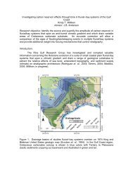
Figure 2. Late Cretaceous Western Interior Seaway and Wasatch Plateau location (Modified after Dubiel<br />
et al., 2000). During this period, coastal‐plain and swampy conditions prevailed over the Plateau. Fluvial<br />
systems, being sourced from Sevier Highlands in the West, traversed through the Plateau before flowed<br />
down to the Western Interior Seaway Basin at eastward direction of the Plateau.