1st Research Conference - Gulf Coast Section SEPM
1st Research Conference - Gulf Coast Section SEPM
1st Research Conference - Gulf Coast Section SEPM

Create successful ePaper yourself
Turn your PDF publications into a flip-book with our unique Google optimized e-Paper software.
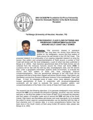
Preservation of Porosity in the Deep<br />
Woodbine/Tuscaloosa Trend, Louisiana<br />
Thomson, Alan, Shell Oil Company, New Orleans, LA (p. 32-34)<br />
Cores of the Woodbine/Tuscaloosa Formation from False RIver Field, Pointe<br />
Coupee Parish, Louisiana, contain sandstones from 20,000 ft with anomalously<br />
high porosities and permeabilities. Porosities greater than 25% and<br />
permeabilities of hundreds of millidarcies are common. Scanning electron<br />
microscopy shows that individual grains of these olive-green, semi-friable<br />
sandstones are coated with chlorite. The chlorite occurs as 7-10µ-wide<br />
hexagonal plates which arrange themselves edgewise one crystal thick on grain<br />
surfaces. Sandstones with more or less continuous chlorite coatings around<br />
quartz grains display little framework compaction and minor development of<br />
secondary quartz overgrowths; however, interbedded sandstones with little or<br />
no chlorite are often completely cemented by secondary quartz. Intermediate<br />
between these extremes are sandstones with incomplete or poorly developed<br />
chlorite coatings; these display outgrowths of secondary quartz rather<br />
overgrowths of an envelope nature.<br />
Petrographic and SEM data indicate an early diagenetic origin for the chlorite<br />
which apparently ceased to form once detrital grains were coated with a single<br />
layer of crystals. This layer was sufficient to mask nucleation sites for silica<br />
overgrowths, and in addition may have prevented compaction by pressure<br />
solution, thereby allowing the sandstones to be buried to great depths without<br />
appreciably reducing porosity.<br />
The chlorite was probably derived from ultrabasic volcanic detritus which is<br />
present in the sandstones to varying degrees. The source of this detritus can be<br />
traced to the peridotite belt of southern Arkansas.<br />
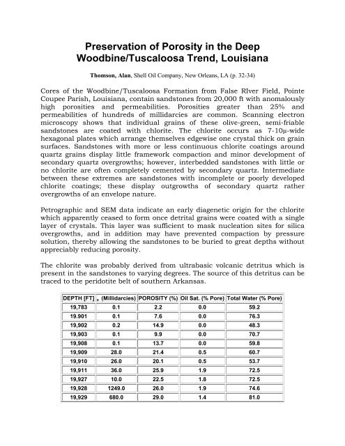
DEPTH [FT] s (Millidarcies) POROSITY (%) Oil Sat. (% Pore) Total Water (% Pore)<br />
19,783 0.1 2.2 0.0 59.2<br />
19.901 0.1 7.6 0.0 76.3<br />
19,902 0.2 14.9 0.0 48.3<br />
19,903 0.1 9.9 0.0 70.7<br />
19,908 0.1 13.7 0.0 59.8<br />
19,909 28.0 21.4 0.5 60.7<br />
19,910 26.0 20.1 0.5 53.7<br />
19,911 36.0 25.9 1.9 72.5<br />
19,927 10.0 22.5 1.8 72.5<br />
19,928 1249.0 26.0 1.9 74.6<br />
19,929 680.0 29.0 1.4 81.0