Petroleum Systems of Deep-Water Basins - Gulf Coast Section SEPM
Petroleum Systems of Deep-Water Basins - Gulf Coast Section SEPM
Petroleum Systems of Deep-Water Basins - Gulf Coast Section SEPM

Create successful ePaper yourself
Turn your PDF publications into a flip-book with our unique Google optimized e-Paper software.
Basement Controls on Hydrocarbon <strong>Systems</strong>,<br />
Depositional Pathways, and Exploration Plays Beyond<br />
the Sigsbee Escarpment in the Central <strong>Gulf</strong> <strong>of</strong> Mexico<br />
Bryan P. Stephens<br />
U.S. Department <strong>of</strong> the Interior<br />
Minerals Management Service<br />
1201 Elmwood Park Blvd.<br />
New Orleans, Louisiana 70123-2394<br />
email-Bryan.stephens@mms.gov<br />
Abstract<br />
Improved understanding <strong>of</strong> the interaction between basement structure, salt tectonics, and depositional systems<br />
can be <strong>of</strong> great value in tract evaluation and resource assessment, particularly in subsalt areas or under-explored,<br />
emerging plays. One such area is the Abyssal Fan Play <strong>of</strong> the ultra-deep water <strong>Gulf</strong> <strong>of</strong> Mexico. Here, an ordered basement<br />
fabric appears to have influenced the vertical juxtaposition <strong>of</strong> potential Mesozoic source rocks, Tertiary<br />
reservoirs, and vertical migration pathways.<br />
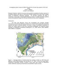
Examination <strong>of</strong> central <strong>Gulf</strong> <strong>of</strong> Mexico tectonic elements, structural features, salt systems, and field distributions<br />
reveals patterns <strong>of</strong> systematic right-lateral <strong>of</strong>fsets along trends that approximate North Atlantic fracture zones.<br />
Regional maps <strong>of</strong> Mesozoic and Tertiary horizons generated from a modern 2x2-mile 2-D seismic grid were used to<br />
interpret transfer fault trends and delineate Mesozoic rift basins beneath the abyssal plain. These basins are seen to be<br />
right-stepping across a series <strong>of</strong> northwest-southeast trending transfer faults in southern Atwater Valley, Walker<br />
Ridge, and Lund. These basins may contain source rocks <strong>of</strong> Jurassic or Cretaceous age. Dramatically high-standing<br />
basement blocks beneath the abyssal plain may be Cretaceous volcanic edifices that exploited the transfer fault zones<br />
during a period <strong>of</strong> post-rift tectonism.<br />
Transfer fault zones may have served as sediment fairways through the salt canopy and fold belt throughout the<br />
Tertiary. Point sources for Miocene deep water fans emanate from the Mississippi Fan Fold Belt where fold axes are<br />
<strong>of</strong>fset along transfer fault zones. The middle Miocene section contains an apron <strong>of</strong> fans just outboard <strong>of</strong> the Sigsbee<br />
Escarpment, but is condensed over most <strong>of</strong> southern Walker Ridge, Atwater Valley, and Lund. However, seismic<br />
facies suggest that some sand-prone middle Miocene fans were directed by basement-controlled fairways beyond the<br />
southern margin <strong>of</strong> Lund and Lund South. Across the northeastern half <strong>of</strong> the abyssal plain, within the corridor<br />
between the Cuban and Campeche fracture zones, regional dip is to the southwest. Across southwestern Lund and<br />
western Walker Ridge, to the west <strong>of</strong> the Campeche fracture zone, regional dip is to the northwest, as the section<br />
climbs toward the Yucatan block. This basin configuration has focused deposition toward southeastern Lund, where<br />
middle Miocene fans onlap the outer reaches <strong>of</strong> the Campeche rise.<br />
Combination structural-stratigraphic traps in middle Miocene fans overlying uplifted basement or Cretaceous volcanic<br />
edifices can be sourced from adjacent rift basins by a series <strong>of</strong> regional joints and fractures. These elements<br />
comprise a new play that extends the Miocene frontier 150 miles south, to the limits <strong>of</strong> U.S. waters.<br />
7