Balmaha - Geological Society of Glasgow
Balmaha - Geological Society of Glasgow
Balmaha - Geological Society of Glasgow

You also want an ePaper? Increase the reach of your titles
YUMPU automatically turns print PDFs into web optimized ePapers that Google loves.
Introduction<br />
Have you ever wondered why Scotland’s landscape is so<br />
sharply divided into Highlands and Lowlands?<br />
<strong>Balmaha</strong> is special to geologists because it is one <strong>of</strong> the<br />
best places to study the Highland Boundary Fault. Follow<br />
a scenic trail <strong>of</strong> only a few miles on good paths along<br />
the shore <strong>of</strong> the loch. Here you can visit three different<br />
fragments <strong>of</strong> the Earth’s crust which have come together<br />
from different parts <strong>of</strong> the globe. You will discover how<br />
solid rock can be squeezed, folded, tilted upwards and split<br />
apart by faults. Many <strong>of</strong> these events happened over 600<br />
million years ago, long before the appearance <strong>of</strong> the first<br />
animals or plants on land.<br />
HIGHLANDS<br />
What do the rocks tell<br />
us about the past?<br />
The Highland Boundary Fault<br />
A fault is a fracture in the Earth’s crust where two blocks<br />
<strong>of</strong> rock have moved relative to each other. The Highland<br />
Boundary Fault stretches across Scotland from the Isle <strong>of</strong><br />
Bute to Stonehaven. Along the line <strong>of</strong> the fault, over 140 miles<br />
from end to end, the gently rolling Lowlands suddenly give<br />
way to the mountainous Highlands.<br />
The Highlands north <strong>of</strong> <strong>Balmaha</strong><br />
The rocks which today form the Southern Highlands were<br />
laid down as sediment at the bottom <strong>of</strong> the sea more than 600<br />
million years ago. As the sediment piled up, the lower layers<br />
were compacted and slowly turned to rock.<br />
Later, the solid rock was squeezed and folded by tremendous<br />
forces and became buried to a depth <strong>of</strong> about 15 to 20<br />
kilometres. The heat and pressure at that depth caused<br />
the original minerals in the rock to recrystallise into new<br />
minerals forming harder rocks. The mudstone turned<br />
into slate or schist, the sandstone became quartzite, and<br />
limestone became marble. The process by which solid rock<br />
changes its structure in this way is called ‘metamorphism’.<br />
These changes to sedimentary rocks occur deep within<br />
mountain belts and are occurring today beneath the<br />
Himalayas. In older mountains, such as the Alps, these<br />
changes have stopped and the mountains are being actively<br />
eroded. The final episode in the formation <strong>of</strong> our own<br />
Caledonian Mountains led to the rocks being uplifted back to<br />
the surface about 400 million years ago and since then they<br />
have suffered continuing erosion. They would originally have<br />
been as high as the Alps are today or perhaps<br />
even the Himalayas. Today’s Scottish<br />
Highlands are just the eroded stumps.<br />
The Lowlands south <strong>of</strong> <strong>Balmaha</strong><br />
The Lowlands are made <strong>of</strong> much<br />
s<strong>of</strong>ter sedimentary rocks which have<br />
never been metamorphosed and still<br />
look quite like the sediments they<br />
once were. The red sandstone was<br />
deposited in rivers when the climate<br />
was much hotter than it is today<br />
and the limestone formed in balmy<br />
lagoons. Coal formed when fallen trees<br />
decomposed in a humid environment.<br />
Climate change is not new !<br />
Why are the Highlands<br />
so different to the<br />
Lowlands?<br />
The difference in height is partly because the hard Highland rocks<br />
have been more resistant to erosion. The Highlands have also been<br />
uplifted relative to the Lowlands due to vertical movements along<br />
the Highland Boundary Fault.<br />
Many geologists believe that the Highland and Lowland blocks<br />
formed in different places and that three continental fragments<br />
(called terranes) joined together around 400 million years ago.<br />
Plates <strong>of</strong> the Earth’s crust, about 120 km thick, can move across<br />
the surface <strong>of</strong> the planet, spreading apart, slipping past or colliding<br />
with each other. They move incredibly slowly, just a few centimetres<br />
each year, about the speed your fingernails grow. Similar processes<br />
are occurring today in places such as Indonesia and along the San<br />
Andreas Fault in California.<br />
Many geologists believe that the Dalradian terrane which today<br />
forms the southern Highlands originated in western South America,<br />
then became attached to North America before finally becoming part<br />
<strong>of</strong> the northwest fringe <strong>of</strong> Europe! The Highland Border terrane is<br />
a narrow band <strong>of</strong> rock just a few hundred metres wide. It contains<br />
fossils which are more like North American fossils than European<br />
ones. The Midland Valley terrane forms the Lowlands south <strong>of</strong><br />
<strong>Balmaha</strong>. It is covered by sedimentary rocks which were laid down<br />
after all three terranes came together. What lies beneath is still<br />
enigmatic.<br />
What’s the evidence for terranes at <strong>Balmaha</strong>?<br />
On the trail you will be able to compare two rocks called<br />
conglomerate and breccia. Both contain large fragments <strong>of</strong> older<br />
rocks which had broken up and become embedded in sediment to<br />
form the new rocks.<br />
You would expect to see fragments <strong>of</strong> Highland rock embedded in<br />
these sediments having been carried by rivers from their source<br />
just a few miles away. The breccia contains many fragments <strong>of</strong> a<br />
typical Highland rock called schist, however the older conglomerate<br />
does not. Therefore many geologists believe that when the pebbly<br />
sediment was being deposited in the Midland Valley terrane, it was<br />
not adjacent to the Dalradian terrane. They only came together in the<br />
time interval between the formation <strong>of</strong> these two rocks.<br />
It is interesting that today the pr<strong>of</strong>essionals are not united in one<br />
view <strong>of</strong> the nature and significance <strong>of</strong> the Highland Boundary Fault<br />
zone. Geology is a dynamic and ever-changing field <strong>of</strong> study.<br />
Southern Upland Fault<br />
Highland Boundary Fault<br />
LOWLANDS<br />
SOUTHERN<br />
UPLANDS<br />
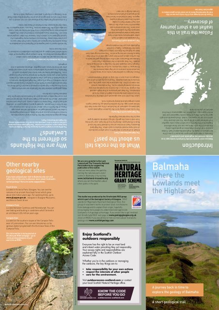
Follow the trail in this<br />
leaflet on a short journey<br />
<strong>of</strong> discovery...<br />
Please do not damage any <strong>of</strong> the rocks you see on this<br />
trail by hammering them as we want future generations to<br />
appreciate them too.<br />
Other nearby<br />
geological sites<br />
If you have enjoyed your visit to <strong>Balmaha</strong> why not visit<br />
other sites in the area to discover more about Scotland’s<br />
varied geology? Here are some suggestions:<br />
Fossil Grove<br />
Located in Victoria Park, <strong>Glasgow</strong>. You can see the<br />
remains <strong>of</strong> an ancient fossilised forest which grew<br />
about 300 million years ago. For opening times, go to<br />
www.glasgow.gov.uk , navigate to <strong>Glasgow</strong> Museums,<br />
and then to Fossil Grove<br />
Ardmore Point<br />
Located between Cardross and Helensburgh. You can<br />
see folding and faulting in sandstone which formed in<br />
an arid desert 375 million years ago.<br />
Campsie Glen<br />
Located on the southern slopes <strong>of</strong> the Campsie Fells<br />
west <strong>of</strong> Lennoxtown. You can see limestones cut by<br />
igneous dykes lying beneath the thick lava flows <strong>of</strong> the<br />
Campsie Fells.<br />
Site information is being posted at<br />
Strathclyde RIGS webpage – go to<br />
www.geologyglasgow.org.uk<br />
and click on RIGS.<br />
We are very grateful to the Loch<br />
Lomond and The Trossachs National<br />
Park Authority for supporting<br />
publication <strong>of</strong> this leaflet.<br />
Find out more about the park by<br />
visiting the national park visitor<br />
centre in <strong>Balmaha</strong> or by visiting<br />
www.lochlomond-trossachs.org<br />
where you will find leaflets about<br />
other paths in the park.<br />
This leaflet was produced by the Strathclyde RIGS group<br />
which is part <strong>of</strong> the <strong>Geological</strong> <strong>Society</strong> <strong>of</strong> <strong>Glasgow</strong>. ‘RIGS’<br />
stands for Regionally Important <strong>Geological</strong> Sites. Our<br />
group <strong>of</strong> volunteers works to protect local rock features<br />
from damage and to explain their origin, hopefully<br />
encouraging more people to understand and appreciate<br />
Scotland’s rich geological heritage. If you would like to get involved<br />
visit Strathclyde RIGS’ web page at www.geologyglasgow.org.uk<br />
(click on RIGS). If you would like to find out more about Scotland’s<br />
geology visit www.scottishgeology.com<br />
Enjoy Scotland’s<br />
outdoors responsibly<br />
Everyone has the right to be on most land<br />
and inland water providing they act responsibly.<br />
Your access rights and responsibilities are<br />
explained fully in the Scottish Outdoor<br />
Access Code.<br />
Whether you’re in the outdoors or managing<br />
the outdoors, the key things are to:<br />
<strong>Balmaha</strong><br />
Where the<br />
Lowlands meet<br />
the Highlands<br />
Beds <strong>of</strong> sandstone breccia<br />
Cliff formed <strong>of</strong><br />
conglomerate<br />
Design & Print: macaulaycreative.co.uk<br />
• take responsibility for your own actions<br />
• respect the interests <strong>of</strong> other people<br />
• care for the environment.<br />
Visit outdooraccess-scotland.com or contact<br />
your local Scottish Natural Heritage <strong>of</strong>fice.<br />
A journey back in time to<br />
explore the geology <strong>of</strong> <strong>Balmaha</strong><br />
A short geological trail
Conic Hill behind the National<br />
Park Visitor Centre<br />
4<br />
Continue on the trail and after<br />
you leave the gravel beach, just<br />
beyond a small stream, you will<br />
see inclined beds <strong>of</strong> a purplered<br />
rock at the water’s edge.<br />
This rock contains very angular<br />
broken fragments <strong>of</strong> rock and<br />
is therefore a type <strong>of</strong> sandstone<br />
called a breccia (pronounced<br />
bretch-iya).<br />
The angular fragments <strong>of</strong><br />
rock within the breccia are in<br />
stark contrast to the rounded<br />
fragments which you saw in<br />
the conglomerate. The broken<br />
rock did not have enough time to<br />
be rounded in the rivers and so<br />
must have travelled a shorter<br />
distance from its source.<br />
8<br />
You may want to return<br />
another day to climb<br />
Conic Hill. The climb<br />
starts from the back<br />
<strong>of</strong> the main car park in<br />
<strong>Balmaha</strong> and will take<br />
you about an hour. The<br />
path is easy to follow<br />
but it is steep all the<br />
way. However the view<br />
is simply breathtaking<br />
as shown on the cover<br />
<strong>of</strong> this leaflet. The<br />
hill is made <strong>of</strong> the<br />
conglomerate rock you<br />
saw at the pier. The hill<br />
marks the northern edge<br />
<strong>of</strong> Scotland’s Lowlands<br />
and sticks up because<br />
the rock is tilted steeply,<br />
a bit like the lip <strong>of</strong> a bowl.<br />
The fragments <strong>of</strong> rock in the<br />
breccia are mostly silverycoloured<br />
schist which is the<br />
same type <strong>of</strong> rock found in the<br />
Highlands just to the north.<br />
In contrast, the conglomerate<br />
you saw earlier contained no<br />
fragments <strong>of</strong> these common<br />
Highland rocks. One theory is<br />
that the sedimentary basin in<br />
which the conglomerate was<br />
formed was nowhere near the<br />
Highlands at that time!<br />
6<br />
Continue on the path to the car<br />
park at Milarrochy Bay. For the<br />
first time on this walk you are<br />
now in the Highlands! Since<br />
leaving the serpentinite you have<br />
crossed the Highland Boundary<br />
Fault although you can’t actually<br />
see any sign <strong>of</strong> it on the path<br />
as the fault is now buried deep<br />
underground. There are no<br />
exposures <strong>of</strong> bedrock in the bay<br />
so if you want to see what typical<br />
highland rock looks like, you<br />
5<br />
Continue on the path through<br />
the woods for about 600 metres.<br />
Just beyond the third wooden<br />
plank bridge look up to your<br />
right where you will see a<br />
small crag. It is an uncommon<br />
green rock with a soapy texture<br />
called serpentinite. It is part <strong>of</strong><br />
a thin group <strong>of</strong> rocks called the<br />
Highland Border Complex which<br />
is sandwiched between the<br />
lowland and highland rocks. You<br />
have therefore crossed a major<br />
geological boundary.<br />
So far on this walk you have seen<br />
sedimentary rocks (containing<br />
fragments <strong>of</strong> metamorphic rock)<br />
deposited by rivers flowing over<br />
land. The Highland Border rocks<br />
are very different. They are about<br />
50 million years older than the<br />
conglomerate and they were<br />
formed on the sea floor rather<br />
than on land. The serpentinite<br />
was originally erupted as molten<br />
magma beneath an ocean floor<br />
and was later metamorphosed.<br />
should drive to<br />
Rowardennan<br />
where you<br />
will see large<br />
exposures <strong>of</strong> the<br />
Rowardennan Pier<br />
silvery folded schist<br />
around the car park.<br />
The shiny silvery colour is due<br />
to a mineral called mica and<br />
the exposures are formed into<br />
smooth humps ground down by<br />
glaciers during the last ice age.<br />
This shows that rock can go<br />
through many, many cycles <strong>of</strong><br />
eruption, erosion, deposition<br />
and metamorphism<br />
over millions or<br />
even billions <strong>of</strong><br />
years. If you<br />
go to the far<br />
northwest <strong>of</strong><br />
Scotland you<br />
will see rock<br />
which has not<br />
changed for<br />
Serpentinite<br />
over two billion<br />
years. However in<br />
Scotland most<br />
<strong>of</strong> the rock you<br />
see has been<br />
‘recycled’<br />
many times<br />
and is<br />
therefore<br />
<strong>of</strong> much<br />
younger age,<br />
just a few<br />
hundred million<br />
years!<br />
Serpentinite Crag<br />
Schist smoothed<br />
by glacier<br />
5<br />
7<br />
1.25 miles<br />
7<br />
0.9 miles<br />
From<br />
Milarrochy<br />
Bay return the<br />
way you came on<br />
the path beside<br />
the loch<br />
6<br />
1.5 miles<br />
If you have time explore the<br />
area <strong>of</strong> bouldery foreshore<br />
which extends about 100 metres<br />
south <strong>of</strong> the ranger station. The<br />
low cliff about a metre high<br />
behind the foreshore is formed<br />
<strong>of</strong> till, <strong>of</strong>ten called boulder<br />
clay. It consists <strong>of</strong> sediment<br />
containing fragments <strong>of</strong> widely<br />
varying sizes left behind when<br />
a glacier melts and releases<br />
the sediment which had been<br />
locked up in<br />
the ice.<br />
Beds <strong>of</strong> sandstone<br />
breccia<br />
4<br />
1<br />
Angular fragments in<br />
the breccia<br />
From the car park go to the<br />
main road then turn right and<br />
follow it round the north side <strong>of</strong><br />
the bay. Do not follow the main<br />
road as it turns right up the<br />
steep hill. Instead, keep to the<br />
shore-side road and look for a<br />
wooden marker post on the right<br />
at the start <strong>of</strong> a stepped path<br />
which climbs quite steeply up<br />
the hillside. Take it slowly – it<br />
should take you about five to ten<br />
minutes to get to the top. At the<br />
summit you will be rewarded<br />
with a magnificent view across<br />
Loch Lomond.<br />
Notice the stark contrast between<br />
the high mountains to the north<br />
and the lower ground to the<br />
south. The loch to the north is<br />
much narrower (and deeper)<br />
than the southern part closer to<br />
you. Loch Lomond was formed<br />
when glaciers flowed from north<br />
to south during the last ice age<br />
between about 2 million and 10,000<br />
years ago.<br />
View south to the<br />
Lowlands<br />
The metamorphic rock underlying<br />
the northern part <strong>of</strong> the loch is<br />
very hard and resistant to erosion<br />
compared to the s<strong>of</strong>ter sandstone<br />
underlying the southern part.<br />
Soil is formed by chemical<br />
weathering <strong>of</strong> the underlying<br />
bedrock. That’s why the best<br />
farmland can be found in the<br />
Lowlands where the sedimentary<br />
rock breaks down more readily to<br />
form fertile soil.<br />
The front cover <strong>of</strong> this leaflet<br />
shows a similar view from<br />
Conic Hill which is the higher<br />
hill behind you. Notice the line<br />
<strong>of</strong> islands stretching away to<br />
the southwest across the loch.<br />
This line <strong>of</strong> islands indicates<br />
the northernmost edge <strong>of</strong> the<br />
Scottish Lowlands marked<br />
by the zone <strong>of</strong> the Highland<br />
Boundary Fault.<br />
View north to Ben Lomond<br />
and the highlands<br />
2<br />
Return downhill to the road and turn<br />
right. Where the road ends at the<br />
old pier take a narrow rocky path<br />
on the right beside the loch. The<br />
path here is cut into a rock called<br />
conglomerate, the same rock<br />
you stood on at the viewpoint. It is<br />
made up <strong>of</strong> large rounded cobbles<br />
<strong>of</strong> quartzite, volcanic rock, and some<br />
granite, packed together in a finergrained<br />
sandy material.<br />
There are several cliffs<br />
to the right <strong>of</strong> the path<br />
between here and the<br />
metal bridge. You will see<br />
that the conglomerate<br />
is comprised <strong>of</strong> beds<br />
which are inclined steeply<br />
to the right, roughly to<br />
the southeast. The beds<br />
were deposited by large rivers<br />
which carried sediment eroded from<br />
high mountains to the northeast. The<br />
broken pieces <strong>of</strong> rock became rounded<br />
as they tumbled against each other in the<br />
powerful river currents. The sediments<br />
were laid down in almost horizontal beds<br />
but these were later tilted up at a steep<br />
angle following vertical movements along<br />
a fault just to the north.<br />
Rounded<br />
conglomerate<br />
The path cut into<br />
the rock<br />
2<br />
0.5 miles<br />
1<br />
0.25 miles<br />
BALMAHA<br />
BAY<br />
3<br />
3<br />
0.7 miles<br />
Continue on the shore-side path<br />
across the metal bridge and after<br />
about 400 metres you will emerge<br />
from the woodland at a long gently<br />
curving bay with a gravel beach.<br />
The high ground is now behind you and<br />
the bay backs onto fairly flat fields. This<br />
is because the rock beneath the bay is<br />
sandstone which eroded more easily<br />
than the harder conglomerate which<br />
forms the hilltop viewpoint. When you<br />
look out to the loch you can see the<br />
same contrast as the wooded island <strong>of</strong><br />
Inchcailloch towards your left is quite<br />
hilly compared to the flatter one ahead<br />
<strong>of</strong> you (called Inchfad). The high hills<br />
at the far side <strong>of</strong> the loch are in the<br />
Highlands so the Highland Boundary<br />
Fault must cross the loch somewhere<br />
behind the islands.<br />
8<br />
Start<br />
Here<br />
National Park<br />
VISITOR Centre<br />
The Trail<br />
Start: The national<br />
park visitor centre in<br />
the large car park at<br />
<strong>Balmaha</strong> which can be<br />
reached by bus from<br />
Balloch.<br />
Terrain: The trail follows good paths, mainly<br />
on the West Highland Way. It keeps close to<br />
the shore <strong>of</strong> the loch so is easy to follow. You<br />
should wear appropriate footwear as the<br />
paths can be muddy and uneven in places.<br />
The paths are mostly fairly flat but the short<br />
detour up to the viewpoint is steep.<br />
Distance: The distance to the<br />
furthest point <strong>of</strong> the walk is a<br />
mile and a half, or three miles<br />
there and back. The return<br />
journey should take you around<br />
two hours on foot although you<br />
can turn back at any point.<br />
Toilets: There are toilets and<br />
refreshments available in<br />
<strong>Balmaha</strong> at the start <strong>of</strong> the trail.<br />
In the summer months there are<br />
also toilets at the furthest point<br />
<strong>of</strong> the route at the Milarrochy Bay<br />
car park.