Sui, Goodchild - UNBC GIS Lab
Sui, Goodchild - UNBC GIS Lab Sui, Goodchild - UNBC GIS Lab
A tetradic analysis of GIS and society using McLuhan’s law of the media DANIEL Z. SUI Department of Geography, Texas A&M University, College Station, TX 77843-3147 USA (e-mail: D-Sui@tamu.edu) MICHAEL F. GOODCHILD National Center for Geographic Information and Analysis, Department of Geography, University of California, Santa Barbara, CA 93106-4060 USA (e-mail: good@geog.ucsb.edu) The social implications of GIS have been debated over the past five years among scholars in several disciplines. GIS have been either conceived by practitioners as value-free, neutral tools for problemsolving or castigated by critical social theorists as socially biased technologies serving only corporate and state interests. Neither of these polarized views is very helpful in understanding the complex relationship between GIS and society. This paper argues that GIS are increasingly becoming media for communicating various crucial social and environmental information to the general public. By reconceptualizing GIS as media, the paper conducts a detailed tetradic analysis on the social implications of GIS using Marshall McLuhan’s law of media. The analysis reveals the paradoxical and ambivalent nature of GIS technology. To make GIS fulfill democratic ideals in society, this paper calls for a shift of perspective, from viewing them as instruments for problem-solving to viewing them as media for communication. This shift from instrumental to communicative rationality enables us to examine more critically and holistically how space, people and environment have been represented, manipulated and visualized in GIS and thus promotes a more critical and democratic GIS practice. Les implications sociales des SIG ont fait l’objet d’un débat au cours des cinq dernières années entre les érudits de plusieurs disciplines. Les SIG furent conçus par des praticiens comme des instruments neutres, non chargés de valeurs, pour la résolution de problèmes, maisils ont été sévèrement critiqués par des théoriciens sociaux comme étant des technologies socialement partiales, qui ne servent que les intérêts des grandes entreprises et de l’État. Aucun de ces deux points de vue contrastés n’est d’une grande utilité pour la compréhension des rapportscomplexes entre les SIG et la société. Cet article soutient que les SIG deviennent de plus en plus un moyen de communiquer au grand public des informations fondamentales sur la société et l’environnement. En redéfinissant les SIG comme un instrument médiatique, cet article conduit une analyse tétradique sur leurs implications sociales sur la base de l’application de la loi des médias de Marshall McLuhan. L’analyse expose la nature paradoxale et ambivalente de la technologie des SIG. Pour que les SIG puissent aider à réaliser les idéaux démocratiques dans la société, cet article demande un changement de perspective, afin de les envisager moins comme des instruments pour la résolution de problèmes et plus comme des formes de communication. Ce changement de raison d’être, d’un instrument à une forme de communication, nous permet de réaliser un examen plus critique et holistique de la façon dont l’espace, les personnes et l’environnement ont été représentés, manipulés et visualisés dans les SIG. II favorise ainsi une application plus critique et plus démocratique des SIG. The Canadian Geographer / Le Géographe canadien 47, no 1 (2003) 5–17 ß / Canadian Association of Geographers / L’Association canadienne des géographes
- Page 2 and 3: 6 Daniel Z. Sui and Michael F. Good
- Page 4 and 5: 8 Daniel Z. Sui and Michael F. Good
- Page 6 and 7: 10 Daniel Z. Sui and Michael F. Goo
- Page 8 and 9: 12 Daniel Z. Sui and Michael F. Goo
- Page 10 and 11: 14 Daniel Z. Sui and Michael F. Goo
- Page 12 and 13: 16 Daniel Z. Sui and Michael F. Goo
A tetradic analysis of <strong>GIS</strong> and society using McLuhan’s<br />
law of the media<br />
DANIEL Z. SUI<br />
Department of Geography, Texas A&M University, College Station, TX 77843-3147 USA (e-mail: D-<strong>Sui</strong>@tamu.edu)<br />
MICHAEL F. GOODCHILD<br />
National Center for Geographic Information and Analysis, Department of Geography, University of California, Santa Barbara, CA 93106-4060 USA<br />
(e-mail: good@geog.ucsb.edu)<br />
The social implications of <strong>GIS</strong> have been debated over<br />
the past five years among scholars in several<br />
disciplines. <strong>GIS</strong> have been either conceived by<br />
practitioners as value-free, neutral tools for problemsolving<br />
or castigated by critical social theorists as<br />
socially biased technologies serving only corporate<br />
and state interests. Neither of these polarized views<br />
is very helpful in understanding the complex<br />
relationship between <strong>GIS</strong> and society. This paper<br />
argues that <strong>GIS</strong> are increasingly becoming media for<br />
communicating various crucial social and<br />
environmental information to the general public. By<br />
reconceptualizing <strong>GIS</strong> as media, the paper conducts a<br />
detailed tetradic analysis on the social implications of<br />
<strong>GIS</strong> using Marshall McLuhan’s law of media. The<br />
analysis reveals the paradoxical and ambivalent<br />
nature of <strong>GIS</strong> technology. To make <strong>GIS</strong> fulfill<br />
democratic ideals in society, this paper calls for a<br />
shift of perspective, from viewing them as<br />
instruments for problem-solving to viewing them as<br />
media for communication. This shift from<br />
instrumental to communicative rationality enables us<br />
to examine more critically and holistically how space,<br />
people and environment have been represented,<br />
manipulated and visualized in <strong>GIS</strong> and thus promotes<br />
a more critical and democratic <strong>GIS</strong> practice.<br />
Les implications sociales des SIG ont fait l’objet d’un<br />
débat au cours des cinq dernières années entre les<br />
érudits de plusieurs disciplines. Les SIG furent conçus<br />
par des praticiens comme des instruments neutres,<br />
non chargés de valeurs, pour la résolution de<br />
problèmes, maisils ont été sévèrement critiqués par<br />
des théoriciens sociaux comme étant des technologies<br />
socialement partiales, qui ne servent que les intérêts<br />
des grandes entreprises et de l’État. Aucun de ces deux<br />
points de vue contrastés n’est d’une grande utilité<br />
pour la compréhension des rapportscomplexes entre<br />
les SIG et la société. Cet article soutient que les SIG<br />
deviennent de plus en plus un moyen de communiquer<br />
au grand public des informations fondamentales sur<br />
la société et l’environnement. En redéfinissant les SIG<br />
comme un instrument médiatique, cet article conduit<br />
une analyse tétradique sur leurs implications sociales<br />
sur la base de l’application de la loi des médias de<br />
Marshall McLuhan. L’analyse expose la nature<br />
paradoxale et ambivalente de la technologie des SIG.<br />
Pour que les SIG puissent aider à réaliser les idéaux<br />
démocratiques dans la société, cet article demande un<br />
changement de perspective, afin de les envisager<br />
moins comme des instruments pour la résolution de<br />
problèmes et plus comme des formes de<br />
communication. Ce changement de raison d’être, d’un<br />
instrument à une forme de communication, nous<br />
permet de réaliser un examen plus critique et<br />
holistique de la façon dont l’espace, les personnes et<br />
l’environnement ont été représentés, manipulés et<br />
visualisés dans les SIG. II favorise ainsi une application<br />
plus critique et plus démocratique des SIG.<br />
The Canadian Geographer / Le Géographe canadien 47, no 1 (2003) 5–17<br />
ß / Canadian Association of Geographers / L’Association canadienne des géographes
6 Daniel Z. <strong>Sui</strong> and Michael F. <strong>Goodchild</strong><br />
Introduction<br />
With the wide-ranging applications of <strong>GIS</strong> 1 that<br />
now exist in various facets of society, especially<br />
their increasing institutionalization in government<br />
agencies at all levels (Masser and Onsrud 1993;<br />
Campbell and Masser 1995; Craglia and Masser<br />
1995; Monmonier 1998), the social implications<br />
of information technology in general and <strong>GIS</strong> technology<br />
in particular have been debated throughout<br />
the 1990s and beyond among scholars in several<br />
disciplines (Chrisman 1987, 1997; Campari and<br />
Frank 1994; Coyne 1995; Sheppard 1995; Pickles<br />
1995, 1997; NCGIA 1996; Harvey 1997; Couclelis<br />
1998; Mugerauer 1998; Yapa 1998; Schuurman<br />
1999, 2000). The traditional conceptualization of<br />
<strong>GIS</strong> as neutral, value-free tools has increasingly<br />
been challenged by critical scholars, yet no consensus<br />
exists on the societal impacts of <strong>GIS</strong> technology.<br />
Although these societal impacts have been<br />
listed as one of the key elements of the National<br />
Science Foundation–sponsored Varenius project<br />
under the banner of ‘geographies of the information<br />
society’ (Sheppard et al. 1999), our current understanding<br />
on this topic remains fragmented, and<br />
there exists no general framework to tie together<br />
all the diverse views. Indeed, as Openshaw<br />
(1996) has so aptly summarized, the discussions<br />
on <strong>GIS</strong> and society have made ‘a lot of fuss about<br />
very little that matters and not enough about that<br />
which does’.<br />
The goal of this paper is to contribute to our<br />
understanding of the relationship between <strong>GIS</strong><br />
and society. By reconceptualizing the role of<br />
<strong>GIS</strong> as media for communicating environmental<br />
and social reality, this paper applies Marshall<br />
McLuhan’s law of media (McLuhan and McLuhan<br />
1988) to conduct a tetradic analysis of the complex<br />
relationship between <strong>GIS</strong> and society and thus<br />
aims to establish a general conceptual framework,<br />
both to examine the social implications of <strong>GIS</strong> technology<br />
and to provide a critical guideline for the<br />
practice of <strong>GIS</strong> in society.<br />
The paper is organized into six sections. After<br />
this brief introduction, a new conceptualization<br />
of <strong>GIS</strong> as media is presented in the second section.<br />
McLuhan’s law of media is introduced in the third<br />
section, and the fourth section uses that law to<br />
conduct a comprehensive analysis of the effects<br />
of <strong>GIS</strong> on society. Further discussions on technological<br />
ambivalence are presented in the fifth section,<br />
followed by concluding remarks in the last<br />
section.<br />
<strong>GIS</strong> as New Media 2<br />
Understanding the relationship between <strong>GIS</strong> and<br />
society is a daunting task, as both terms mean<br />
different things to different people and the relationship<br />
between the two is similarly debatable. A<br />
review of the definitions of <strong>GIS</strong> in the early 1990s<br />
(Maguire 1991) reveals that at least 25 different<br />
definitions were, at that time, widely circulated in<br />
the <strong>GIS</strong> literature. The concept of society is even<br />
more elusive, considering the different theories of<br />
society developed by social scientists and theorists<br />
(Giddens 1984). Although it is beyond the<br />
scope of this paper to resolve the inconsistencies<br />
among these different conceptualizations of <strong>GIS</strong><br />
and of society, it is crucial to re-examine the meaning<br />
of <strong>GIS</strong> in the light of developments that have<br />
occurred in the past five years in order to better<br />
understand its impacts on society.<br />
The dazzling development of <strong>GIS</strong> technology in<br />
recent years has rendered each of the traditional,<br />
mostly instrumental views of <strong>GIS</strong>—as spatial<br />
database, mapping tool and spatial analytical<br />
tool—inadequate to capture the essence of this<br />
technology and its social implications. Each year,<br />
innovative developers offer new software<br />
packages that are easier to use, more powerful<br />
and more easily adopted by users with minimal<br />
training. <strong>GIS</strong> and mapping tools are increasingly<br />
available on the World Wide Web (WWW), and an<br />
increasing number of sites offer advanced <strong>GIS</strong><br />
services, such as route-finding and geocoding.<br />
In-vehicle navigation systems using <strong>GIS</strong> technology<br />
are becoming part of our daily lives (Cowen<br />
1994). In the next two years, cell phones in the US<br />
will be required to be geographically enabled—to<br />
be able to report their current location to an<br />
accuracy of 100 m—in the interests of accurate<br />
response to emergency calls. New imagery with<br />
spatial resolutions as fine as 1 m is becoming<br />
available from commercial sources and is being<br />
distributed through new mechanisms, such as<br />
distributed geolibraries and spatial data clearinghouses<br />
(NRC 1993, 1999). New methods of data<br />
documentation are being used to support widespread<br />
sharing of spatial data via the Internet.<br />
These new trends contrast sharply with the earlier<br />
view, which prevailed into the early 1990s, of <strong>GIS</strong><br />
The Canadian Geographer / Le Géographe canadien 47, no 1 (2003)
Tetradic analysis of <strong>GIS</strong> and society 7<br />
as tools contained within a stand-alone computing<br />
system, serving the needs of their professional<br />
users by performing various forms of analysis too<br />
tedious, time-consuming or expensive to perform<br />
by hand, on data collected and assembled for the<br />
purpose.<br />
Media are generally understood as means of<br />
sending messages or communicating information<br />
to the general public, and mass media are the<br />
instruments by which mass communication takes<br />
place in modern societies. Mass media are also the<br />
most effective means of broadcasting information<br />
to large numbers of people in a short period of<br />
time. In a very general sense, <strong>GIS</strong> can be understood<br />
as a new technological species in an already<br />
crowded media jungle, a species specifically<br />
focused on the communication of geographic<br />
information. The fact that <strong>GIS</strong> communicates geographic<br />
information in digital form merely illustrates<br />
its consistency with contemporary media,<br />
which now make widespread use of digital encoding<br />
at various stages. By reconceptualizing <strong>GIS</strong> as<br />
new media, we can gain fresh insights into the<br />
relationship between <strong>GIS</strong> and society, because the<br />
impacts of media are much better understood<br />
today as a result of years of interdisciplinary<br />
research. In this paper, Marshall McLuhan’s law<br />
of media is invoked to demonstrate how media<br />
theories can shed light on the social implications<br />
of <strong>GIS</strong>.<br />
Before doing so, however, it is appropriate to<br />
take a close look at the meaning of <strong>GIS</strong> as new<br />
media. This thesis can be broadly understood in<br />
at least the following dual senses. First, <strong>GIS</strong><br />
increasingly have become a means to communicate<br />
certain aspects of the real world to the general<br />
public. The Environmental Systems Research Institute<br />
(ESRI, in Redlands, California) advertises its<br />
<strong>GIS</strong> software products as a ‘common language’ for<br />
speaking about and ‘discovering’ the world, while<br />
Intergraph (Huntsville, Alabama) goes so far as to<br />
name its products ‘GeoMedia’. The role of communication<br />
is superseding the three traditional<br />
conceptualizations of <strong>GIS</strong> noted above (as tools<br />
for database management, mapping and spatial<br />
analysis), because the impacts of <strong>GIS</strong> are realized<br />
only when results are presented to people on<br />
screens or on paper. Thus, communication in its<br />
broadest sense must be given the central position<br />
when we discuss relationships between <strong>GIS</strong> and<br />
society. Software vendors may have recognized<br />
this role of <strong>GIS</strong> better than many of their customers<br />
have done. Although data inventory and database<br />
management, automated mapping and spatial<br />
analysis are still predominant tasks of most <strong>GIS</strong><br />
projects, in the end, the goal of all <strong>GIS</strong> operations<br />
is to communicate information to an audience in<br />
society. All <strong>GIS</strong>-related activities serve this final<br />
purpose—to communicate; all other functions,<br />
such as data storage, management analysis and<br />
so on, are intermediate steps serving primarily as<br />
means to communicative ends. For example, analysis<br />
is what the sender uses to expose what the<br />
receiver might not otherwise perceive; database<br />
management makes it easier for the receiver to<br />
understand the content by using standard<br />
structures and metadata.<br />
Second, in the past decade significant changes<br />
have occurred in the part played by digital geographic<br />
information in people’s lives. Sites such<br />
as Mapquest provide millions of users every day<br />
with customized maps of routes and destinations,<br />
and sites such as Terraserver offer digital remotesensing<br />
imagery for sale to the general public. The<br />
Weather Channel and local television stations<br />
present forecasts incorporating geographic information<br />
from satellite images and display maps<br />
of forecasts from advanced computational models<br />
(Monmonier 2000). Airline passengers are presented<br />
with dynamic maps of their flight’s progress.<br />
<strong>GIS</strong> were even featured prominently in the<br />
CBS TV crime-fighting series ‘‘The District’’ (Kaplan<br />
2000). Although humans have always needed to<br />
communicate geographic information in describing<br />
discoveries, giving directions or registering<br />
ownership, recent technological developments<br />
appear to have opened a new range of possibilities<br />
quite different from what we have gotten used to.<br />
Indeed, with the emergence of digital places and<br />
digital individuals (Curry 1998), we are witnessing<br />
not only Toynbee’s (1972) etherialization of history<br />
but also the etherialization of geography.<br />
It should be pointed out that emphasis on the<br />
communication aspect of <strong>GIS</strong> has its parallels in<br />
cartography. Robinson and Petchenik (1975) first<br />
introduced Shannon’s communication theory to<br />
understand the map-making process. Bertin (1978)<br />
further elaborated on linkages between the theory<br />
of communication and the theory of graphics.<br />
Martin (1996) tried to apply the Robinson-Petchenik<br />
communication model of cartography to understanding<br />
<strong>GIS</strong>. By reconceptualizing cartography as<br />
The Canadian Geographer / Le Géographe canadien 47, no 1 (2003)
8 Daniel Z. <strong>Sui</strong> and Michael F. <strong>Goodchild</strong><br />
a language for communication, Tobler (1979)<br />
introduced Chomsky’s (1957) linguistic theory to<br />
develop a ‘transformation theory’ of the cartographic<br />
process. Nyerges (1980) further explored<br />
Chomsky’s ‘deep structure’ versus ‘surface structure’<br />
in both cartographic and <strong>GIS</strong> contexts.<br />
Indeed, the communication paradigm dominated<br />
the cartographic research literature even in the<br />
1970s and the 1980s (MacEachren 1995). The<br />
recent literature on the basic issues of geographic<br />
information science (<strong>GIS</strong>ci) has also invoked<br />
various linguistic metaphors to study geographic<br />
information processing from the perspectives of<br />
communication and linguistics (Frank and Mark<br />
1991; <strong>Goodchild</strong> 2000).<br />
However, the majority of these previous works<br />
is framed by a cognitive approach that focuses on<br />
perception-related issues in map design. The<br />
cognitive approach emphasizes perceptive aspects<br />
of both map-readers and designers at the micro-<br />
(individual) level. In other words, the cognitive<br />
approach has engaged us in discussing technically<br />
oriented syntax issues (rules and grammars<br />
governing the relationships among signifiers);<br />
few authors have touched upon the complex and<br />
problematic semantic issues in geographic information<br />
visualization (the relationship between the<br />
signifier and the signified). Using communication<br />
theorist James Carey’s (1989) words, all these<br />
previous works are dominated by the ‘transmission<br />
view’ of communication at the technical level<br />
(how information is transmitted across space).<br />
What is lacking in the current literature is the<br />
‘ritual view’ of communication at the cultural and<br />
philosophical levels (how information is preserved<br />
in time).<br />
This paper will take up the challenge to examine<br />
cultural and philosophical implications of <strong>GIS</strong> in<br />
society, using McLuhan’s law of media at the<br />
macrolevel. Our current work is conceptually in<br />
line with Harley’s (1989) ground-breaking work in<br />
making the power relationship explicit in the<br />
map-making process, and it resonates with the<br />
recent literature on maps as social constructions<br />
(Crampton 2001). As geographers’ earlier works<br />
have revealed (Burgess and Gold 1985; Zonn<br />
1990; Hay and Israel 2001), media plays an important<br />
role in the public’s perception of many critical<br />
issues in society. How geography is communicated<br />
via the media of <strong>GIS</strong> obviously demands critical<br />
scrutiny.<br />
McLuhan’s Law of Media<br />
Originally trained in literary criticism and medieval<br />
literature, Canadian communication theorist<br />
Marshall McLuhan made his name in the 1960s and<br />
the 1970s with his groundbreaking studies concerning<br />
media’s impacts on individuals and on<br />
society. His studies on media are best represented<br />
by his trilogy: The Mechanical Bride—Folklore<br />
of Industrial Man (1951); The Gutenburg Galaxy—<br />
The Making of Typographic Man (1962); and Understanding<br />
Media—The Extension of Man (1964).<br />
In retrospect, McLuhan was celebrated in the<br />
1960s for the wrong reasons. With the appearance<br />
of CNN, MTV, the Internet, and the World Wide<br />
Web, McLuhan’s writings make much more sense in<br />
1994 than they did in 1964 (Press 1995; Benedetti<br />
and DeHart 1997; Biro 2000; Genosko 2000;<br />
Horrocks 2000). As a controversial figure caught<br />
in a struggle between tradition and modernity, we<br />
believe, McLuhan was deserted by the academy too<br />
early and too soon. It is time to re-evaluate those of<br />
McLuhan’s theories that were hotly contested in<br />
the late 1960s (Stearn 1967; Crosby and Bond<br />
1968; Finkelstein 1968; Rosenthal 1968). As it is<br />
beyond the scope of this paper to present<br />
a comprehensive review of McLuhan’s complex<br />
ideas, readers are referred to Neill (1983), Gordon<br />
(1997) and Grosswiler (1997) for general overviews,<br />
and to Levinson (1999) and Theall (2001)<br />
for McLuhan’s relevance for the new digital age<br />
led by the Internet. What follows is a brief introduction<br />
to McLuhan’s law of media, which will be<br />
used to examine the social implications of <strong>GIS</strong><br />
technology.<br />
Although McLuhan’s followers regard him as a<br />
clairvoyant whose pungent and integrative<br />
insights have functioned as goads to contemporary<br />
thinkers, he was dismissed in the 1970s and<br />
the early 1980s by most social scientists and<br />
literary scholars as a marginal man from a marginal<br />
country who got it all wrong. Just like his<br />
sudden appearance in Woody Allen’s Oscarwinning<br />
movie, Annie Hall, McLuhan was brought<br />
back onto centre stage in media studies in the early<br />
1990s, again hailed by his disciples as a man who<br />
used his probes as drills to pierce the crust of<br />
humankind’s perceptions, constrained and dulled<br />
by the technical environment (Benedetti and<br />
DeHart 1997; Genosko 2000). McLuhan’s obsession<br />
with enlightened insights enabled him to make many<br />
The Canadian Geographer / Le Géographe canadien 47, no 1 (2003)
Tetradic analysis of <strong>GIS</strong> and society 9<br />
hits using his intellectual handgun, the one-sentence<br />
aphorism. Many of McLuhan’s catchy phrases—such<br />
as ‘the global village’, ‘the medium is the message’,<br />
and ‘the TV treats the eye as the ear’—have become<br />
part of the contemporary popular lexicon.<br />
McLuhan and many of his followers believe that<br />
there have been three dominant modes of communication<br />
throughout human history: oral/speech,<br />
writing/printing press, and the electronic medium.<br />
Each dominant medium has produced dramatically<br />
different psychic and physical impacts on individuals<br />
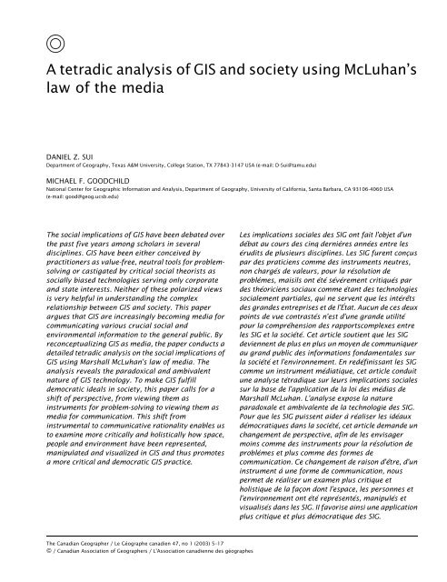
and on society as a whole. McLuhan succinctly<br />
summarized these impacts as the law of media,<br />
presented in the tetradic framework (Figure 1)<br />
in a book coauthored with his son Eric and published<br />
posthumously (McLuhan and McLuhan<br />
1988). McLuhan’s law of media has four major<br />
elements: any innovations in the dominant mode of<br />
communication media will invariably (a) intensify/<br />
enhance certain aspects of human faculties or a<br />
given culture, while at the same time (b) making<br />
certain aspects of human mental abilities or cultural<br />
practices obsolete. Furthermore, all media<br />
innovations also (c) retrieve a phase of certain<br />
human capabilities or cultural practices long ago<br />
pushed aside and (d) undergo a reversal when<br />
extended beyond the limits of their potential. The<br />
four phases of the tetrad manifest, in advance, the<br />
Figure 1<br />
McLuhan’s law of media. SOURCE: Modified after McLuhan and McLuhan<br />
(1988)<br />
cultural impacts of an artefact by showing how<br />
total saturated use would produce a reversal of<br />
original intent.<br />
McLuhan’s law of media interweaves two fundamental<br />
elements key to understanding his tetradic<br />
model: (1) the distinction between visual and<br />
acoustic space and (2) the relationship between<br />
figure and ground as outlined in Gestalt psychology.<br />
According to McLuhan (1964), dichotomous<br />
intellectual discourses are reflections of bifurcated<br />
minds deeply rooted in the visual mode of<br />
thinking—the result of the Gutenberg (printing<br />
press) revolution. McLuhan and Powers (1989)<br />
further argue that the ‘visual space’ mindset leaves<br />
little room for alternatives or for participation<br />
when no provision is made for two entirely different<br />
points of view. The result is usually the exclusion<br />
of alternative perspectives. To fully<br />
comprehend the new reality mediated by the electronic<br />
medium, McLuhan and Powers (1989) call<br />
for a fundamental shift from the values of linear<br />
thinking (visual, proportional space) to those of<br />
the multisensory life (the experience of acoustic<br />
space). Visual thinking places information structurally<br />
and sequentially—having separate centres<br />
with fixed boundaries. Acoustic thinking regards<br />
things as interconnected simultaneously—having<br />
centres everywhere with boundaries nowhere.<br />
Visual thinking is thus centred and bounded.<br />
Acoustic thinking is built on holistic and organic<br />
ontology. Acoustic space has no cardinal centre,<br />
just many centres floating in a cosmic system<br />
that honours only diversity. This shift demands<br />
that we engage in simultaneous understanding<br />
and integral awareness. As one of us has argued<br />
elsewhere (<strong>Sui</strong> 2000), the shift from a predominantly<br />
visual metaphor to an aural one is one of the<br />
major changes in geographical discourses in the<br />
late 20th century. Such a change was made possible<br />
by an array of philosophical, technological,<br />
and social changes in society. At the very fundamental<br />
level, visual and aural thinking entail different<br />
sets of epistemological values, orchestrated<br />
as by the eye versus the ear. We now know that<br />
sound imposes its concreteness on us by immersing<br />
and surrounding us in its field and that sound<br />
tends always to socialize. Voice is inherently relational<br />
and subjective. In contrast, sight entails an<br />
object world fixed in space, giving an illusion of<br />
permanence. Vision is thus inherently detached<br />
and objective.<br />
The Canadian Geographer / Le Géographe canadien 47, no 1 (2003)
10 Daniel Z. <strong>Sui</strong> and Michael F. <strong>Goodchild</strong><br />
Also implicitly woven into McLuhan’s tetrad is<br />
the concept of figure/ground, borrowed from<br />
Gestalt psychology: enhancement and retrieval as<br />
two figures and obsolescence and reversal as two<br />
grounds. Visual thinking usually stresses one figure<br />
or one ground, but rarely both. Acoustic thinking<br />
engages us in double figures and double<br />
grounds and enables us simultaneously to evaluate<br />
the overall effects of an artefact on society.<br />
McLuhan believes that every product of human<br />
effort manifests the same four dimensions. His<br />
tetrad enables us to reposition ourselves into a<br />
holistic perceptive mode—the mode of the dynamically<br />
many-centred—and to move away from the<br />
monolithic linear visual image. Instead of simplistic<br />
utopian and dystopian views, McLuhan’s inclusive<br />
and irreducible four-part law of media<br />
provides a better conceptual framework within<br />
which to understand the relationship between <strong>GIS</strong><br />
and society. As an exploratory probe resting on a<br />
set of questions, instead of a bounded theory, the<br />
tetrad will facilitate our simultaneous understanding<br />
and integral awareness. To confine ourselves<br />
to only one metaphor, as most authors have done<br />
so far, is to engage in synecdoche—to mistake the<br />
part for the whole (<strong>Sui</strong> 1998).<br />
<strong>GIS</strong> and Society: A Tetradic Analysis<br />
If <strong>GIS</strong> are indeed becoming new media for communicating<br />
various forms of social and environmental<br />
information in society (<strong>Goodchild</strong> 2000; <strong>Sui</strong> and<br />
<strong>Goodchild</strong> 2001), it will be interesting to take a<br />
close look at the extent to which McLuhan’s law of<br />
media can be applied to examine the impacts of<br />
<strong>GIS</strong>. Tying the relationship between <strong>GIS</strong> and<br />
society to McLuhan’s law of media, we will conduct<br />
a tetradic analysis by answering the four questions<br />
raised in McLuhan’s framework. In this paper,<br />
society is conceptualized as a collection of complex,<br />
interacting webs of social, economic, political<br />
and cultural relationships among individuals<br />
and institutions.<br />
<strong>GIS</strong> and society I: what do <strong>GIS</strong> enhance?<br />
It is common knowledge, and generally agreed<br />
upon by <strong>GIS</strong> practitioners and critics alike, that<br />
<strong>GIS</strong> have greatly facilitated data inventory and<br />
database management of georeferenced information.<br />
<strong>GIS</strong> also provide users with a variety of<br />
exciting new tools for analyzing and visualizing<br />
geographic information. If we follow McLuhan’s<br />
axiom that all media are extensions of people,<br />
<strong>GIS</strong> have definitely extended human faculties in<br />
several ways. As far as drawing and mapping are<br />
concerned, <strong>GIS</strong> have extended our hands for production<br />
of a variety of virtual and real maps. As<br />
far as fieldwork is concerned, <strong>GIS</strong> have<br />
extended our eyes through increasing integration<br />
with remote sensing and aerial photography. As far<br />
as navigation skills are concerned, <strong>GIS</strong> have<br />
extended the brain’s powers through increased<br />
adoption of car navigation systems and integration<br />
of real-time global positioning systems (GPSs). As<br />
far as human central nervous systems are concerned,<br />
<strong>GIS</strong> have extended our minds and thinking<br />
abilities through integration with artificial intelligence,<br />
expert systems, various kinds of spatial<br />
analysis and modeling and even the incorporation<br />
of emotions into computing processes (Openshaw<br />
and Openshaw 1997; Picard 1997). In many ways,<br />
<strong>GIS</strong> have also enhanced accessibility of geographic<br />
information for a wide range of users throughout<br />
society. Since most <strong>GIS</strong> courses are offered by geography<br />
departments in North America (Morgan 1996),<br />
<strong>GIS</strong> have undoubtedly improved the visibility of<br />
geography both in the academy and in society.<br />
Although numerous organizational issues still<br />
need to be resolved, the rapid diffusion of <strong>GIS</strong> into<br />
various government agencies and corporate settings<br />
not only has greatly enhanced application of<br />
georeferenced information in interesting and exciting<br />
ways, but has also promoted <strong>GIS</strong> as a new science<br />
in and of itself (Wright et al. 1997). From a broader<br />
perspective, <strong>GIS</strong> must be understood as a part of the<br />
information revolution that has transformed our<br />
society from an industrial into a postindustrial one.<br />
During this process, <strong>GIS</strong> certainly have become part<br />
of society’s transition from the mode of production<br />
to the mode of information (Poster 1990).<br />
<strong>GIS</strong> and society II: what do <strong>GIS</strong> make obsolete?<br />
In opposition to predominant techno-utopian<br />
views, McLuhan’s scheme further proposes that<br />
new media and technologies do not simply extend<br />
our various mental and physical faculties. To the<br />
contrary, media also simultaneously make obsolete<br />
(or ‘amputate’) various social practices and<br />
human faculties. By ‘obsolescence’, McLuhan does<br />
not mean the total disappearance or outdating of<br />
certain social practices, but rather that certain<br />
The Canadian Geographer / Le Géographe canadien 47, no 1 (2003)
Tetradic analysis of <strong>GIS</strong> and society 11<br />
media or social practices are no longer dominant.<br />
<strong>GIS</strong> do not simply extend our mapping capabilities<br />
without cost. <strong>GIS</strong> also simultaneously make obsolete<br />
many aspects of traditional cartographic practices,<br />
such as the use of drawing pens. In other<br />
words, <strong>GIS</strong> are killing certain aspects of cartography<br />
as we know it (<strong>Goodchild</strong> 1999). Likewise, for an<br />
increasing number of <strong>GIS</strong> users, the technology has<br />
made obsolete many traditional field techniques<br />
and has even partially eliminated the desire to<br />
collect first-hand data, as so many secondary data<br />
are available in digital format on CD or via the Web.<br />
The reliance on secondary data for research and<br />
social applications has profound legal, ethical and<br />
methodological implications (Sheppard 1993).<br />
During the past decade, we have witnessed more<br />
and more geographic research being conducted in<br />
the office at the computer screen, rather than in<br />
the field. Agencies such as the US Forest Service,<br />
which used to rely heavily on personnel located in<br />
the field, now place more and more emphasis on<br />
digital information management in the office as a<br />
primary agency function. Whether this results in<br />
better forest management is clearly an increasingly<br />
important question. Whether the new development<br />
in field technologies 3 can reverse this<br />
trend remains to be seen.<br />
The impacts of <strong>GIS</strong> on analytical and navigational<br />
skills are even easier to detect. Just as the<br />
use of calculator and cash register has ‘amputated’<br />
mental arithmetic among some users, the increasing<br />
deployment of technologies such as GPS and<br />
wireless computing in the field may be ‘amputating’<br />
or making obsolete valued skills of directionfinding<br />
and navigation. Today, we can easily<br />
generate a digital elevation model (DEM) by simply<br />
pressing a few buttons in ArcView, using either the<br />
inverse distance or Kriging method, but <strong>GIS</strong> users<br />
often express more interest in learning how to<br />
operate a particular software package to produce<br />
impressive output than in understanding how its<br />
algorithms work. One of the consequences of<br />
access to powerful <strong>GIS</strong> tools may be a greater interest<br />
in doing the thing right rather than in doing the<br />
right thing. In McLuhan’s words, the medium is<br />
indeed becoming the message.<br />
<strong>GIS</strong> and society III: what do <strong>GIS</strong> retrieve?<br />
The third element of McLuhan’s framework is that<br />
new media also retrieve certain practices and cultural<br />
elements long regarded as obsolete. One of<br />
the grand themes of his thesis—and perhaps the<br />
most controversial—holds that electronic media<br />
are breaking from the dominant linear thinking<br />
patterns of the printed word, which itself made<br />
obsolete the oral tradition as the dominant mode<br />
of communication in many facets of society. In<br />
sharp contrast to the printing press, which is a<br />
predominately visual medium, electronic media<br />
are aural and tactile, geared toward the ear or<br />
other senses. That is, electronic media are retrieving<br />
many traits of the oral culture—a phenomenon<br />
that Ong (1982) calls the second orality.<br />
In the context of <strong>GIS</strong>, the retrieval aspect has<br />
gone through several stages. The initial success<br />
of <strong>GIS</strong> relied heavily on integration of automated<br />
mapping and database-management systems for<br />
data inventory and database-management purposes.<br />
Deficiencies in analytical capabilities motivated<br />
the <strong>GIS</strong> community to retrieve many of the<br />
techniques developed during the quantitative<br />
revolution, as evidenced by efforts during the late<br />
1980s and early 1990s to link <strong>GIS</strong> with spatial analysis<br />
and modeling tools (<strong>Goodchild</strong> et al. 1992).<br />
These efforts to improve the analytical capabilities<br />
of <strong>GIS</strong> have led to the realization that our current<br />
conceptualizations of space and time in <strong>GIS</strong> are<br />
incomplete (Rundstrom 1991, 1995; Huffman<br />
1996; NCGIA 1996; Pickles 1998; Miller 2000).<br />
Thus, the second major retrieval within <strong>GIS</strong> is the<br />
study and incorporation of naïve geography, as<br />
evidenced by the National Center for Geographic<br />
Information and Analysis (NCGIA) research initiatives<br />
and the Varenius project’s focus on cognitive<br />
models of the geographic world and their potential<br />
role in development of better tools (Egenhofer and<br />
Mark 1995; Mark et al. 1999). The limits of computation<br />
have revealed the vast terrae incognitae that<br />
humanistic geographers have explored using nonscientific<br />
rules (<strong>Sui</strong> 2001). The third major retrieval<br />
effort within <strong>GIS</strong> is the recent endeavour by <strong>GIS</strong><br />
researchers, as well as critical social theorists, to<br />
link <strong>GIS</strong> to various aspects of social theories in<br />
order to guide current practices, as evidenced by<br />
NCGIA’s initiative 19 (I-19) and the emphasis in the<br />
Varenius project on the emerging geography of the<br />
information society. These research efforts<br />
obviously have moved away from the dominance<br />
of mapping (for the eye) to a more multisense/<br />
multimedia mode of representing different voices<br />
and narratives (for the ear). This trajectory of <strong>GIS</strong><br />
The Canadian Geographer / Le Géographe canadien 47, no 1 (2003)
12 Daniel Z. <strong>Sui</strong> and Michael F. <strong>Goodchild</strong><br />
and <strong>GIS</strong>ci development is interpreted as a reflection<br />
of McLuhan’s theme of the retrieval of orality<br />
by electronic media.<br />
Perhaps even more significant is that the retrieval<br />
capabilities of <strong>GIS</strong> remind us of shifting metaphors<br />
in our social discourse—from the visual mode,<br />
dominated by the eye, to the aural mode, dominated<br />
by the ear. What <strong>GIS</strong> have retrieved is<br />
re-emphasis on the role of speech, narrative and<br />
even rhetoric. <strong>GIS</strong> as media do not simply present<br />
beautiful images or maps for people to look at;<br />
behind these pictures is usually a story to be read<br />
or a speech to be heard. Aspects of aurality also<br />
appear, either consciously or unconsciously, in <strong>GIS</strong><br />
design (Gould 1994). In many applications, <strong>GIS</strong><br />
have increasingly become rhetorical devices to<br />
create meaning and discourse (<strong>Sui</strong> 1998). To follow<br />
and understand <strong>GIS</strong> rhetoric, which is similar to<br />
that Smith (1996) demonstrates for geographical<br />
writings in general, we must understand their<br />
tropes and modes and their roles in determining<br />
our conclusions. Instead of regarding <strong>GIS</strong> as ‘a distant<br />
mirror’ faithfully reflecting reality (Pickles<br />
1999), it is perhaps more appropriate to treat <strong>GIS</strong><br />
as ‘a close dialogue’ among different players in<br />
society. By shifting our ocular metaphor to an<br />
aural one, we can be more sensitive to different<br />
voices and, possibly, to silences as well.<br />
At a more anecdotal level, it is perhaps not coincidental<br />
that <strong>GIS</strong> software packages have been<br />
named Idrisi and research projects have been<br />
called the Alexandria Digital Library or the Varenius<br />
project. These names also work to retrieve aspects<br />
of the past and to emphasize connections between<br />
contemporary technology and much older concerns.<br />
<strong>GIS</strong> and society IV: what do <strong>GIS</strong> reverse into?<br />
The last proposition of McLuhan’s law of media is<br />
that when a medium is pushed to its limit, it will be<br />
reversed into the opposite of what it was originally<br />
designed for. In McLuhan’s (1964, 23) words, ‘[W]e<br />
become what we behold; we first make the tools,<br />
then the tools will make us’. Using numerous<br />
examples of human artefacts and technologies,<br />
McLuhan tries to show that in the beginning,<br />
media are extensions of people, but in time people<br />
become extensions of media. When a medium is<br />
pushed to its limit, it becomes the message itself.<br />
Critical scholars of technology give this process a<br />
variety of different names, such as ‘Marx’s alienation’<br />
(Ollman 1977), ‘reversed adoption’ (Veregin<br />
1995), ‘technopoly’ (Postman 1992) and ‘colonization<br />
of lifeworld’ (Habermas 1987). Echoing what<br />
Wittgenstein demonstrated for language, McLuhan<br />
proposes that when a medium is pushed to its<br />
limit, it is no longer just the vehicle, but also the<br />
driver. Indeed, when we surrender our goals and<br />
social practices to the technical requirements of a<br />
machine, the technology itself becomes what Max<br />
Weber called an ‘iron cage’ (Scaff 1989). When this<br />
occurs, the cage locks up our imagination and creativity.<br />
To McLuhan and many of his followers,<br />
media are not simply ‘making-aware’ agents but<br />
also—and perhaps more importantly—‘makinghappen’<br />
agents. Taken in isolation, this reversal<br />
concept may easily be construed as a technologydeterministic<br />
argument. In fact, McLuhan’s law of<br />
media only makes sense when its four elements are<br />
taken into consideration as a whole in his tetradic<br />
framework.<br />
In the context of <strong>GIS</strong>, what worries most social<br />
theorists is that computerization of the natural<br />
and cultural may inevitably lead to the naturalization<br />
and culturalization of the computerized. This<br />
trend, if not deconstructed critically, will have<br />
serious social and philosophical consequences. In<br />
more and more real-world situations, we have witnessed<br />
incidents where organizational mandates<br />
or problems themselves are modified to meet<br />
requirements of <strong>GIS</strong> technology. Data models<br />
force representations on the world by requiring<br />
them to follow certain rules, such as separation of<br />
complex systems into geographical layers or imposition<br />
of crisp, Boolean categories on systems<br />
which are inherently fuzzy. If the only available<br />
means of solving a problem is a <strong>GIS</strong> with no way<br />
of representing uncertainty, it seems much simpler<br />
to ignore uncertainty than to insist on better<br />
tools.<br />
When <strong>GIS</strong> are reversed into their opposites, they<br />
cease to promote democratic practices in society.<br />
Instead, <strong>GIS</strong> developments and applications are<br />
driven by corporate greed or the state’s insatiable<br />
desire to survey and collect intrusive information<br />
from ordinary citizens (Goss 1995). Consequently,<br />
we become slaves of our media, instead of using<br />
media to serve our higher goals and aspirations.<br />
Some critics warn that <strong>GIS</strong>, coupled with other<br />
information technologies, will become a super<br />
Panopticon to monitor and survey, rather than to<br />
The Canadian Geographer / Le Géographe canadien 47, no 1 (2003)
Tetradic analysis of <strong>GIS</strong> and society 13<br />
help, ordinary citizens, especially the truly disadvantaged<br />
(<strong>Sui</strong> 1998).<br />
Perhapsevenmoreproblematicarethephilosophical<br />
consequences that result when <strong>GIS</strong> reverse<br />
into their opposites. Given their increasingly<br />
numerous and versatile visualization capabilities,<br />
<strong>GIS</strong> may give users a false sense of what is real and<br />
thus a very shaky ontology (Gregory 1994; Raper<br />
1997). Even more troubling is that these pictures<br />
make people feel more real—hyperreal, which is, in<br />
fact, unreal. Based upon their studies of the TV<br />
advertising industry, Mitroff and Bennis (1993)<br />
find that deliberate manufacturing of falsehood<br />
and fantasy is not only profitable but has become<br />
part of our culture, as electronic media become the<br />
dominant mode of representation. They further<br />
point out that two kinds of unreality are produced:<br />
(1) artificial reality, in which it is often difficult to<br />
differentiate between actual and virtual worlds,<br />
and (2) pseudoreality, in which attractive presentation<br />
overwhelms the desire to differentiate the<br />
real from the unreal. Turkle (1995, 169) terms the<br />
first form of unreality the ‘Disneyland Effect (the<br />
artificial seems real)’ and the second the ‘Artificial<br />
Crocodile Effect (the fake seems more compelling<br />
than the real)’. These ontological effects have<br />
tended to suppress alternative ways of knowing,<br />
suggesting that <strong>GIS</strong> may become a prison which<br />
traps us into particular modes of knowing and separates<br />
us from the real world and its problems (Curry<br />
1998). To Heidegger (1977), the real danger of the<br />
inherent enframing nature of technology comes not<br />
from potentially lethal machines or the apparatus<br />
of technology itself. Rather, the danger lies in our<br />
becoming increasingly blind to alternative ways of<br />
looking at things as we turn to technology for solutions<br />
to social problems. In this sense, <strong>GIS</strong> as media<br />
represent more than mere exterior aids; they represent<br />
interior transformations of consciousness as<br />
well. When and if this indeed happens, it would be<br />
more apt to say that <strong>GIS</strong> stands for geographic illusion<br />
systems (Couclelis 1996). Indeed, when<br />
pushed to their limits, <strong>GIS</strong> are just the electronic<br />
version of Plato’s cave: what we see on the screen<br />
are only illusions of reality.<br />
Dealing with Technological<br />
Ambivalence<br />
The central theme of McLuhan’s law of media<br />
states that the effects of media (or technologies<br />
in general) on society are inherently paradoxical.<br />
As both Tuan (1989) and Tenner (1996) have elucidated<br />
with fascinating examples, such paradoxical<br />
effects defy simplistic good or bad characterizations<br />
from either technological utopian or dystopian<br />
perspectives. Instead, we must try to grasp<br />
four aspects simultaneously. McLuhan’s implicit<br />
message is that the social impacts of technology<br />
are ambivalent. Excessive use of technologies<br />
always leads to the opposite of what they are<br />
designed for. In the context of <strong>GIS</strong>, it is futile to<br />
debate whether <strong>GIS</strong> are good or bad for society.<br />
The only meaningful question will be: how can we<br />
reveal and deal with the ambivalent nature of <strong>GIS</strong><br />
applications in society?<br />
The reconceptualization of <strong>GIS</strong> as new media<br />
constitutes a fundamental paradigm shift in current<br />
<strong>GIS</strong> practices, from instrumental rationality to<br />
communicative rationality (Habermas 1984, 1987).<br />
It has been argued that most current <strong>GIS</strong> applications<br />
are dominated by instrumental rationality, in<br />
which <strong>GIS</strong> have been treated as a value-free and<br />
neutral tool to generate objective facts. Under<br />
instrumental rationality, the social ends of <strong>GIS</strong><br />
applications are being facilitated, justified and<br />
sometimes even defined by its technical means.<br />
Results of <strong>GIS</strong> applications have been used in practice<br />
to validate action without attending to the<br />
values embedded in the <strong>GIS</strong> media. This paper<br />
argues that such an implicit instrumental conceptualization<br />
of <strong>GIS</strong> in society has unduly restricted<br />
the questions that can be asked and has created a<br />
false sense of objectivity in public discourse.<br />
McLuhan’s work provides us with a powerful<br />
framework to understand the social (sometimes<br />
unintended) consequences of <strong>GIS</strong> applications.<br />
By re-emphasizing the communicative nature of<br />
<strong>GIS</strong> technology, we can better understand the<br />
elusive nature of the <strong>GIS</strong> language. Furthermore,<br />
by appreciating <strong>GIS</strong>’s role as media, we can<br />
better understand how individuals and organizations<br />
systematically manipulate communications<br />
to conceal possible problems and solutions,<br />
manipulate consent and trust and misrepresent<br />
facts and expectations. <strong>GIS</strong> technology, like all<br />
other media and communication tools, can be<br />
abused by individuals and organizations to manipulate<br />
results and to legitimate and impose political,<br />
economic and social agendas. The shift from instrumental<br />
to communicative rationality will enable us<br />
to examine more critically how space, people and<br />
The Canadian Geographer / Le Géographe canadien 47, no 1 (2003)
14 Daniel Z. <strong>Sui</strong> and Michael F. <strong>Goodchild</strong><br />
environment have been represented, manipulated<br />
and visualized in <strong>GIS</strong>, and thus to promote more<br />
democratic <strong>GIS</strong> practice in the social arena.<br />
Although McLuhan successfully identified the<br />
ambivalent nature of technological development,<br />
the solutions he prescribed are controversial.<br />
According to McLuhan, the only way to escape<br />
technological paradoxes is to resolutely oppose<br />
all technological advances (Kroker 1985; Benedetti<br />
and DeHart 1997). This casts McLuhan in the role<br />
of latter-day Luddite and is obviously not a viable<br />
solution. As everything is rapidly becoming computerized<br />
in the emerging information society,<br />
humanity as a whole will run deeper and deeper<br />
into such technological paradoxes. The tools and<br />
technologies we deploy to study society have<br />
increasingly become part of the society we try to<br />
study using those same tools. This technological<br />
self-referentiality, similar in a way to the linguistic<br />
self-referentiality exemplified by Russell’s paradox,<br />
4 will inevitably make it impossible to provide<br />
technical solutions to social problems. To transcend<br />
such a technological paradox, we must<br />
clearly define and continuously redefine our social<br />
goals, not allowing any technologies to dictate<br />
what we do and why we do it. Just as Wittgenstein<br />
(1922) tries so strenuously to prove that we cannot<br />
express everything about language using language<br />
itself, we cannot solve social problems using technologies<br />
such as <strong>GIS</strong> alone. The following statement<br />
from Wittgenstein’s Tractatus Logico-<br />
Philosophicus provides an intriguing perspective<br />
on the theme of this paper:<br />
My propositions are elucidatory in this way: he who<br />
understands me finally recognizes them as senseless,<br />
when he has climbed out through them, on<br />
them, over them. (He must so to speak throw away<br />
the ladder, after he has climbed up on it.)<br />
He must surmount these propositions; then he sees<br />
the world rightly.<br />
Whereof one cannot speak, thereof one must be silent<br />
(Wittgenstein 1922, 148).<br />
Concluding Remarks: The Messages<br />
of <strong>GIS</strong><br />
The meanings of <strong>GIS</strong> have undergone several major<br />
transformations during the past five years. As<br />
Boorstin (1987) pointed out, the supreme law of<br />
the republic of technology is convergence—the<br />
tendency for everything to become everything<br />
else. In the case of <strong>GIS</strong>, they have evolved from<br />
being an arcane tool for mapping and spatial analysis<br />
to becoming an integral part of mass media to<br />
communicate geographic information in society.<br />
Throughout the 1990s, debates about the social<br />
implication of <strong>GIS</strong> technology shifted from simple<br />
attacks on positivism to incorporating more subtle<br />
analyses of the effects of the technology (Schuurman<br />
2000). In this paper, we continue to make an<br />
effort at such analyses. By reconceptualizing <strong>GIS</strong><br />
as media, we aim to develop a more synthetic,<br />
robust framework to better understand the social<br />
implications of <strong>GIS</strong> technology. The tetradic analysis<br />
of <strong>GIS</strong> as media, conducted using McLuhan’s<br />
framework, has revealed some interesting hidden<br />
messages of <strong>GIS</strong>, which defy the frequent dichotomous<br />
characterization of <strong>GIS</strong> as either good or bad.<br />
Instead, <strong>GIS</strong> transmit a complex set of messages of<br />
simultaneous enhancement, obsolescence, retrieval<br />
and reversal in society. By reconceiving <strong>GIS</strong> as<br />
media, we can transcend the instrumental<br />
rationality currently rampant among both <strong>GIS</strong><br />
developers and <strong>GIS</strong> practitioners and cultivate a<br />
more holistic approach to nonlinear relationships<br />
between <strong>GIS</strong> and society. The clear and<br />
present danger is not <strong>GIS</strong> or information<br />
technologies, but our blissful ignorance of the<br />
implications of what they are going to do to<br />
us, because we have concentrated too much on<br />
what <strong>GIS</strong> can do for us. The only sensible way of<br />
dealing with this inherent technological ambivalence<br />
is to always treat <strong>GIS</strong> media as means to<br />
higher social ends.<br />
It is generally accepted as a truism among<br />
students of technological impacts on society that<br />
all technologies are, in a philosophical sense,<br />
Faustian bargains and that we love technology<br />
because our psyches are so narcissistic. Current<br />
applications of <strong>GIS</strong> in society are dominated by<br />
the Narcissus myth—we are obsessed by the pretty<br />
pictures on the screen—and many <strong>GIS</strong> Fausts have<br />
inadvertently sold their souls to the technologies.<br />
Awakening from the Narcissus myth demands<br />
nothing short of a phoenix transformation of our<br />
consciousness (Buttimer 1993). The reconceptualization<br />
of <strong>GIS</strong> as media reveals the Faustian nature<br />
of <strong>GIS</strong> technology and shows us how we can escape<br />
from the Narcissus myth using McLuhan’s law of<br />
The Canadian Geographer / Le Géographe canadien 47, no 1 (2003)
Tetradic analysis of <strong>GIS</strong> and society 15<br />
media. Such an intellectual exercise is aimed at<br />
making <strong>GIS</strong> a real phoenix, rising out of the deconstructive<br />
ashes to new heights. Only by such a<br />
transformation in our consciousness can we make<br />
<strong>GIS</strong> into a Noah’s Ark with which to survive the<br />
current information flood.<br />
Acknowledgements<br />
We thank Helen Couclelis, Jonathan Phillips, Paul Adams,<br />
Rush Cohen, Judith White and Daniel Overton for providing critical<br />
comments on an earlier version of this paper, and Bing Lu for<br />
research assistance. Constructive comments from two anonymous<br />
reviewers are also gratefully acknowledged. The Varenius project<br />
and the Alexandria Digital Library are supported through cooperative<br />
agreements between the University of California, Santa<br />
Barbara, and the US National Science Foundation.<br />
Notes<br />
1 ‘<strong>GIS</strong>’ are used as a plural in this paper.<br />
2 This section draws on our recent editorial in the International<br />
Journal of Geographical Information Science; see <strong>Sui</strong> and<br />
<strong>Goodchild</strong> (2001) for details.<br />
3 Visit the NCGIA’s Web site for the details of Project Battuta.<br />
4 Russell’s paradox is based on examples like this: Consider a<br />
group of barbers who shave only those men who do not shave<br />
themselves. Suppose there is a barber in this collection who<br />
does not shave himself; then, by the definition of the collection,<br />
he must shave himself. But no barber in the collection can shave<br />
himself. (If so, he would be a man who does shave men who<br />
shave themselves.)<br />
References<br />
BENEDETTI, P. and DEHART, N. 1997 Forward through the Rearview<br />
Mirror: Reflections on and by Marshall McLuhan (Cambridge,<br />
MA: MIT Press)<br />
BERTIN, J. 1978 ‘Theory of communication and theory of the graphic’<br />
International Yearbook of Cartography 28, 118–126<br />
BIRO, G.M. 2000 Marshall McLuhan Meets the Millennium Bug (New<br />
York: Uplevel Publishing)<br />
BOORSTIN, D.J. 1987 Hidden History (New York: Harper and Row)<br />
BURGESS, J. and GOLD, J.R. 1985 Geography, the Media, and Popular<br />
Culture (New York: St. Martin’s Press)<br />
BUTTIMER, A. 1993 Geography and the Human Spirit (Baltimore: John<br />
Hopkins University Press)<br />
CAMPARI, I. and FRANK, A.U. 1994 ‘Cultural differences in <strong>GIS</strong>: a basic<br />
approach’ in E<strong>GIS</strong>’94 (Proceedings of European <strong>GIS</strong> Conference),<br />
ed J. Harts, H.F.L. Ottens and H.J. Scholten (Utrecht, the<br />
Netherlands: E<strong>GIS</strong> Foundation) 10–16<br />
CAMPBELL, H. and MASSER, I. 1995 <strong>GIS</strong> and Organizations: How Effective<br />
Are <strong>GIS</strong> in Practice? (London: Taylor and Francis)<br />
CAREY, J.W. 1989 Communication as Culture: Essays on Media and<br />
Society (Boston: Unwin Hyman)<br />
CHOMSKY, N. 1957 Syntactic Structures (The Hague: Mouton)<br />
CHRISMAN, N.R. 1987 ‘Design of geographic information systems based<br />
on social and cultural goals’ Photogrammetric Engineering and<br />
Remote Sensing 53, 1367–1370<br />
—. 1997 Exploring Geographic Information Systems (New York:<br />
John Wiley and Sons)<br />
COUCLELIS, H. 1996 ‘Geographic illusion systems: towards a (very<br />
partial) research agenda for <strong>GIS</strong> in the information age’ in <strong>GIS</strong><br />
and Society: The Social Implications of How People, Space, and<br />
Environment Are Represented in <strong>GIS</strong> ed T. Harris and D. Weiner,<br />
Technical Report 96–7 (Santa Barbara, CA: National Center for<br />
Geographic Information and Analysis) D12–13<br />
—. 1998 ‘Spatial information technologies and societal problems’<br />
in Geographic Information Research: Trans-Atlantic<br />
Perspectives, ed M. Craglia and H. Onsrud (London: Taylor and<br />
Francis) 15–24<br />
COWEN, D.J. 1994 ‘The importance of <strong>GIS</strong> for the average person’<br />
Proceedings of First Federal Geographic Technology Conference,<br />
Washington, DC 7–11<br />
COYNE, R. 1995 Designing Information Technology in the Postmodern<br />
Age: From Method to Metaphor (Cambridge, MA: MIT Press)<br />
CRAGLIA, M. and MASSER, I. 1995 <strong>GIS</strong> Diffusion: The Adoption of Use of<br />
Geographical Information Systems in Local Government in<br />
Europe (London: Taylor and Francis)<br />
CRAMPTON, J.W. 2001 ‘Maps as social constructions: power,<br />
communication, and visualization’ Progress in Human<br />
Geography 25(2), 235–252<br />
CROSBY, H.H. and BOND, G.R. 1968 The McLuhan Explosion: ACasebook<br />
on Marshall McLuhan and Understanding Media (New York:<br />
American Book Co.)<br />
CURRY, M.R. 1998 Digital Places: Living with Geographic Information<br />
Technologies (London: Blackwell)<br />
EGENHOFER, M. and MARK, D.M. 1995 ‘Naive geography’ in Spatial<br />
Information Theory: ATheoretical Basis for <strong>GIS</strong>, ed A.U. Frank<br />
and W. Kuhn, Lecture Notes in Computer Science 988 (Berlin:<br />
Springer-Verlag) 1–15<br />
FINKELSTEIN, S. 1968 Sense and Nonsense of McLuhan (New York:<br />
International Publishers)<br />
FRANK, A.U. and MARK, D.M. 1991 ‘Language issues for <strong>GIS</strong>’ in<br />
Geographical Information Systems: Principles and Applications,<br />
ed D.J. Maguire, M.F. <strong>Goodchild</strong> and D.W. Rhind (Harlow:<br />
Longman Scientific and Technical) 147–163<br />
GENOSKO, G. 2000 McLuhan and Baudrillard: The Masters of Implosion<br />
(New York: Routledge)<br />
GIDDENS, A. 1984 The Constitution of Society (Oxford: Polity Press)<br />
GOODCHILD, M.F. 1999 ‘<strong>GIS</strong> and geography: elements of a debate’<br />
Yearbook of the Association of Pacific Coast Geographers 60,<br />
150–157<br />
—. 2000 ‘Communicating geographic information in a digital age’<br />
in Annals of the Association of American Geographers 90(2),<br />
344–355<br />
GOODCHILD, M.F., HAINING, R. and WISE, S. 1992 ‘Integrating <strong>GIS</strong> and spatial<br />
data: problems and possibilities’ International Journal of<br />
Geographical Information Systems 6, 407–23<br />
GORDON, W.T. 1997 McLuhan for Beginners (Toronto: Writers and<br />
Readers)<br />
GOSS, J. 1995 ‘We know who you are and we know where you live: the<br />
instrumental rationality of geodemographic systems’ Economic<br />
Geography 71, 171–198<br />
GOULD, M.D. 1994 ‘<strong>GIS</strong> design: a hermeneutic view’ Photogrammetric<br />
Engineering and Remote Sensing 60, 1105–1115<br />
GREGORY, D. 1994 Geographical Imaginations (Cambridge, MA: Blackwell)<br />
GROSSWILER, P. 1997 The Method is the Message: Rethinking McLuhan<br />
through Critical Theory (New York: Black Rose Books Ltd.)<br />
HABERMAS, J. 1984 The Theory of Communicative Action Vol. 1<br />
(Boston: Beacon Press)<br />
—. 1987 The Theory of Communicative Action Vol. 2 (Boston:<br />
Beacon Press)<br />
The Canadian Geographer / Le Géographe canadien 47, no 1 (2003)
16 Daniel Z. <strong>Sui</strong> and Michael F. <strong>Goodchild</strong><br />
HARLEY, B. 1989 ‘Deconstructing the map’ Cartographica 26, 1–20<br />
HARVEY, F. 1997 ‘From geographic holism to geographic information<br />
system’ The Professional Geographer 49(1), 77–85<br />
HAY, I. and ISRAEL, M. 2001 ‘‘‘Newsmaking geography’’: Communicating<br />
geography through the media’ Applied Geography 21(2),<br />
107–125<br />
HEIDEGGER, M. 1977 The Question Concerning Technology, and Other<br />
Essays (New York: Garland)<br />
HORROCKS, C. 2000 Marshall McLuhan and Virtuality (New York:<br />
Totem Books)<br />
HUFFMAN, N.H. 1996 ‘You can’t get here from there: reconstructing the<br />
relevancy of design in postmodernism’ in Cartographic Design:<br />
Theoretical and Practical Perspectives, ed C.H. Wood and<br />
C.P. Keller (New York: John Wiley and Sons) 35–53<br />
KAPLAN, K. 2000 ‘Mapping software has role in ‘‘The District’’’ Los<br />
Angeles Times 16 October, D11<br />
KROKER, A. 1985 Technology and the Canadian Mind: Innis/McLuhan/<br />
Grant (New York: St. Martin’s Press)<br />
LEVINSON, P. 1999 Digital McLuhan: AGuide to the Information<br />
Millennium (New York: Routledge)<br />
MACEACHREN, A.M. 1995 How Maps Work: Representation, Visualization,<br />
and Design (New York: Guilford Press)<br />
MAGUIRE, D.J. 1991 ‘An overview and definition of <strong>GIS</strong>’ in Geographical<br />
Information Systems: Principles and Applications, ed D.J. Maguire,<br />
M.F. <strong>Goodchild</strong> and D.W. Rhind (Harlow: Longman Scientific and<br />
Technical) 9–20<br />
MAPQUEST http://www.mapquest.com (last accessed 13 January<br />
2003)<br />
MARK, D.M., FREKSA, C., HIRTLE, S.C., LLOYD, R. and TVERSKY, B. 1999 ‘Cognitive<br />
models of geographic space’ International Journal of Geographical<br />
Information Science 13(8), 747–774<br />
MARTIN, D. 1996 Geographic Information Systems: Socioeconomic<br />
Applications 2nd ed. (London: Routledge)<br />
MASSER, I. and ONSRUD, H.J. 1993 Diffusion and Use for Geographic<br />
Information Technologies (Boston: Kluwer Academic Press)<br />
MCLUHAN, M. 1951 The Mechanical Bride: Folklore of Industrial Man<br />
(New York: Vanguard Press)<br />
—. 1962 The Gutenberg Galaxy: The Making of Typographic Man<br />
(Toronto: University of Toronto Press)<br />
—. 1964 Understanding Media: The Extension of Man (London:<br />
Sphere Books)<br />
MCLUHAN, M. and MCLUHAN, E. 1988 Laws of Media: The New Science<br />
(Toronto: University of Toronto Press)<br />
MCLUHAN, M. and POWERS, B.R. 1989 The Global Village: Transformations<br />
in World Life and Media in the 21st Century (New York: Oxford<br />
University Press)<br />
MILLER, H.J. 2000 ‘Geographic representations in spatial analysis’<br />
Journal of Geographical Systems 2(1), 55–60<br />
MITROFF, I.I. and BENNIS, W. 1993 The Unreality Industry: The Deliberate<br />
Manufacturing of Falsehood and What It Is Doing to Our Lives<br />
(New York: Oxford University Press)<br />
MONMONIER, M. 1998 ‘The three Rs of <strong>GIS</strong>-based site selection:<br />
representation, resistance and ridicule’ in Policy Issues in<br />
Modern Cartography, ed D.R.F. Taylor (London: Pergamon)<br />
164–175<br />
—. 2000 Air Apparent: How Meteorologists Learned to Map, Predict,<br />
and Dramatize Weather (Chicago: University of Chicago Press)<br />
MORGAN, J.M. 1996 Directory of Academic <strong>GIS</strong> Education (Dubuque, IA:<br />
Kendall/Hunt Publishing Co.)<br />
MUGERAUER, R. 1998 ‘Qualitative <strong>GIS</strong>: to mediate, not dominate’ in<br />
Information, Place, and Cyberspace: Issues in Accessibility ed<br />
D.G. Janelle and D.C. Hodge (Berlin: Springer) 317–338<br />
NATIONAL CENTER FOR GEOGRAPHIC INFORMATION AND ANALYSIS (NCGIA) 1996<br />
Advancing Geographic Information Science: A Research Agenda<br />
Santa Barbara, CA: National Center for Geographic Information<br />
and Analysis http://www.ncgia.ucsb.edu/secure/main.html<br />
—. Project Battuta http://dg.statlab.iastate.edu/dg/ (last accessed<br />
13 January 2003)<br />
NATIONAL RESEARCH COUNCIL (NRC) 1993 Toward a Coordinated Spatial<br />
Data Infrastructure for the Nation (Washington, DC: National<br />
Academy Press)<br />
—. 1999 Distributed Geolibraries: Spatial Information Resources<br />
(Washington, DC: National Academy Press)<br />
NEILL, S.D. 1983 Clarifying McLuhan (Westport, CT: Greenwood Press)<br />
NYERGES, T.L. 1980 ‘Modeling the structure of cartographic<br />
information for query processing’ Ph.D. dissertation, Ohio<br />
State University<br />
OLLMAN, B. 1977 Alienation: Marx’s Conception of Man in Capitalist<br />
Society (New York: Cambridge University Press)<br />
ONG, W.J. 1982 Orality and Literacy: The Technologizing of the Word<br />
(New York: Methuen)<br />
OPENSHAW, S. 1996 ‘<strong>GIS</strong> and society: a lot of fuss about very little that<br />
matters and not enough about that which does’ in <strong>GIS</strong> and<br />
Society: The Social Implications of How People, Space, and<br />
Environment Are Represented in <strong>GIS</strong> ed T. Harris and D. Weiner,<br />
Technical Report 96–7 (Santa Barbara, CA: National Center for<br />
Geographic Information and Analysis) D54–58<br />
OPENSHAW, S. and OPENSHAW, C. 1997 Artificial Intelligence in Geography<br />
(New York: John Wiley and Sons)<br />
PICARD, R.W. 1997 Affective Computing (Cambridge, MA: MIT Press)<br />
PICKLES, J. 1995 Ground Truth: The Social Implications of Geographic<br />
Information Systems (New York: Guilford Press)<br />
—. 1997 ‘Tool or science? <strong>GIS</strong>, technoscience, and theoretical turn’<br />
Annals of the Association of American Geographers 87(2),<br />
363–372<br />
—. 1998 ‘Arguments, debates, and dialogues: the <strong>GIS</strong>-social theory<br />
debate and the concern for alternatives’ in Geographical<br />
Information Systems: Principles, Techniques, Management and<br />
Applications ed P.A. Longley, M.F. <strong>Goodchild</strong>, D.J. Maguire and<br />
D.W. Rhind (New York: John Wiley and Sons) 49–60<br />
—. 1999 ‘Cartography, digital transitions, and questions of history’<br />
in Proceedings, International Cartographic Association Assembly,<br />
Ottawa, August (Ottawa: Canadian Institute of Geomatics)<br />
CD-ROM<br />
POSTMAN, N. 1992 Technopoly: The Surrender of Culture to<br />
Technology (New York: Knopf)<br />
POSTER, M. 1990 The Mode of Information: Poststructuralism and<br />
Social Context (Chicago: University of Chicago Press)<br />
PRESS, L. 1995 ‘McLuhan meets the Net’ Communications of the ACM<br />
38(7), 15–20<br />
RAPER, J. 1997 ‘Unresolved problems of spatial representation’ in<br />
Advances in <strong>GIS</strong> Research II ed M.J. Kraak and M. Molenaar<br />
(London: Taylor and Francis) 917–928<br />
ROBINSON, A.H. and PETCHENICK, B.B. 1975 ‘The map as a communication<br />
system’ The Cartographic Journal 12(1), 7–14<br />
ROSENTHAL, R. 1968 McLuhan: Pro and Con (Baltimore: Penguin)<br />
RUNDSTROM, R. 1991 ‘Mapping, postmodernism, indigenous people,<br />
and the changing direction of North American cartography’<br />
Cartographica 28, 1–12<br />
—. 1995 ‘<strong>GIS</strong>, indigenous peoples, and epistemological diversity’<br />
Cartography and Geographic Information Systems 22(1), 45–57<br />
SCAFF, L.A. 1989 Fleeing the Iron Cage: Culture, Politics, and<br />
Modernity in the Thought of Max Weber (Berkeley: University of<br />
California Press)<br />
The Canadian Geographer / Le Géographe canadien 47, no 1 (2003)
Tetradic analysis of <strong>GIS</strong> and society 17<br />
SCHUURMAN, N. 1999 Critical <strong>GIS</strong>: Theorizing an Emerging Science<br />
Cartographica Monograph no. 53 (Toronto: University of<br />
Toronto Press)<br />
—. 2000 ‘Trouble in the heartland: <strong>GIS</strong> and its critics in the 1990s’<br />
Progress in Human Geography 24(4): 569–590<br />
SHEPPARD, E. 1993 ‘Automated geography: what kind of geography for<br />
what kind of society?’ The Professional Geographer 45, 457–460<br />
—. 1995 ‘<strong>GIS</strong> and society: towards a research agenda’ Cartography<br />
and Geographic Information Systems 22, 5–16<br />
SHEPPARD, E., COUCLELIS, H., GRAHAM, S., HARRINGTON, W. and ONSRUD, H. 1999<br />
‘Geographies of the information society’ International Journal of<br />
Geographical Information Science 13(8), 797–824<br />
SMITH, J.M. 1996 ‘Geographic rhetoric: modes and tropes of appeal’<br />
Annals of the Association of American Geographers 86(1), 1–20<br />
STEARN, G. E. 1967 McLuhan: Hot and Cool (New York: Dial Press)<br />
SUI, D.Z. 1998 ‘Deconstructing virtual cities: from unreality to<br />
hyperrealtiy’ Urban Geography 19(7), 657–676<br />
—. 2000 ‘Visuality, aurality, and the shifting metaphors in<br />
geographic thought in the late 20th century’ Annals of the<br />
Association of American Geographers 90(2), 322–343<br />
—. 2001 ‘Terrae incognitae and limits of computation: whither<br />
<strong>GIS</strong>cience?’ Computers, Environment, and Urban Systems 29(5),<br />
529–533<br />
SUI, D.Z. and GOODCHILD, M.F. 2001 ‘Are <strong>GIS</strong> becoming new media?’<br />
International Journal of Geographical Information Science<br />
15(5), 387–390<br />
TENNER, E. 1996 Why Things Bite Back: Technology and the Revenge of<br />
Unintended Consequences (New York: Knopf)<br />
TERRASERVER http://www.terraserver.com<br />
THEALL, D.F. 2001 The Virtual Marshall McLuhan (Montreal: McGill<br />
University Press)<br />
TOBLER, W.R. 1979 ‘A transformational view of cartography’ The<br />
American Cartographer 6(2), 101–106<br />
TOYNBEE, A. 1972 AStudy of History Updated ed. (New York:<br />
Weathervane Books)<br />
TUAN, Y.F. 1989 Morality and Imagination: Paradoxes of Progress<br />
(Madison: The University of Wisconsin Press)<br />
TURKLE, S. 1995 Life on the Screen: Identity in the Age of the Internet<br />
(New York: Simon and Schuster)<br />
VEREGIN, H. 1995 ‘Computer innovation and adoption in geography:<br />
A critique of conventional technological models’ in Ground<br />
Truth: Social Implications of Geographic Information Systems<br />
ed J. Pickles (New York: The Guilford Press) 88–112<br />
WITTGENSTEIN, L. 1922 Tractatus Logico-Philosophicus (London:<br />
Routledge and Kegan Paul Ltd.)<br />
WRIGHT, D.J., GOODCHILD, M.F. and PROCTOR, J.D. 1997 ‘<strong>GIS</strong>: tool or science?’<br />
Annals of the Association of American Geographers 87, 346–362<br />
YAPA, L. 1998 ‘Why <strong>GIS</strong> needs postmodern social theory, and vice<br />
versa’ in Policy Issues in Modern Cartography ed D.R.F. Taylor<br />
(London: Pergamon) 191–201<br />
ZONN, L. 1990 Place Images in Media: Portrayal, Experience, and<br />
Meaning (Savage, MD: Rowman and Littlefield)<br />
The Canadian Geographer / Le Géographe canadien 47, no 1 (2003)


