JDSF Newsletter - State of California
JDSF Newsletter - State of California
JDSF Newsletter - State of California

Create successful ePaper yourself
Turn your PDF publications into a flip-book with our unique Google optimized e-Paper software.
- u_--uu u<br />
- - - ---<br />
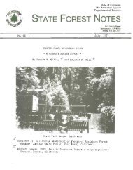
JDSplS CAMP 20 VISITOR CERTER:<br />
A NEW FORESTRY EDUCATION STOP ON HIGHWAY 20<br />
As part <strong>of</strong> our mandate to<br />
demonstrate forest management<br />
activities, plans were developed<br />
eighteen months ago to construct<br />
a visitor center at Camp 20.<br />
This area has historically been a<br />
rest stop for travelers using<br />
<strong>State</strong> Highway 20. Each year,<br />
thousands <strong>of</strong> tourists and most<br />
local residents use this road to<br />
trave 1 between Fort Bragg and<br />
WIllItS. As Camp 20 is centrally<br />
located vetween these two towns<br />
and <strong>of</strong>fers an excellent stopping<br />
point for travelers, we decided<br />
to further develop this area.<br />
The early stagecoach road going<br />
by Camp 20 originated on the<br />
coast at Mendocino and ended at<br />
the Ukiah Valley. To transport<br />
logs to their mill, the Caspar<br />
Lumber Compavy later developed a<br />
railroad system ~rom the mouth <strong>of</strong><br />
Caspar Creek, over the coastal<br />
flats and up Hare Creek. A<br />
tunnel was constructed through to<br />
the South Fork <strong>of</strong> the Noyo River<br />
and the rail line eventually was<br />
extended to Camp 20, about 15<br />
miles from the ocean. The<br />
present day Highway 20 near Camp<br />
20 follows along part <strong>of</strong> the<br />
stage route and the railroad<br />
grade.<br />
Norm Henry<br />
Camp 20 was the last logging camp<br />
built by Caspar Lumber Company,<br />
opening in 1939. Several dozen<br />
small houses were built here for<br />
the logging crews. In addition,<br />
a cookhouse was built based on a<br />
design Kelly McGuire, logging<br />
superintendent for the Caspar<br />
Lumber Company, observed in the<br />
Sierra. A store, schoolhouse and<br />
"donkey shop" were moved from<br />
Camp 19 to tnis site during this<br />
time as well. The latter<br />
structur-e was originally constructed<br />
at Camp One and used for<br />
steam donkey repairs. At Camp<br />
20, it's eventual use was for log<br />
truck and Caterpillar repair.<br />
Tractor yarding began in 1~28 and<br />
the building's name was changed<br />
to the "cat barn".<br />
When the <strong>State</strong> <strong>of</strong> <strong>California</strong><br />
purchased the Company's lands in<br />
1947, everything left on the site<br />
became state property. Today,<br />
the only logging camp structures<br />
remaining are the "cat barn" and<br />
the schoolhouse. Another relic<br />
from the Camp is a steam donkey<br />
owned by the Caspar Lumber Company.<br />
It was located on the north<br />
sIde <strong>of</strong> the highway, across from<br />
the existing picnic grounds and<br />
ball field. The donkey was left<br />
----------------------------------------------------------------------<br />
CALIFORNIA DEPARTMENT OF FORESTRY AND FIRE PROTECTION<br />
Richard J. Ernest, Director<br />
Geo~ge Deukmejian<br />
Governor<br />
<strong>State</strong> <strong>of</strong> <strong>California</strong><br />
1<br />
Gordon K. Van Vleck<br />
Secretary for Resources<br />
The Resources Agency
where the railroad grade came out<br />
<strong>of</strong> the Chamberlain Creek drainage.<br />
It is a large double drum<br />
machine made by the Willamette<br />
Iron and Steelworks <strong>of</strong> Portland<br />
in about 1910. Wood fires below<br />
boiler tubes in the donkey generated<br />
enough steam pressure to<br />
winch in old-growth redwood logs.<br />
This was accomplished by turning<br />
drums spooled with large diameter<br />
cable. The donkey was moved<br />
around on 55-foot Douglas-fir log<br />
skids.<br />
For many years, Camp 20 has been<br />
used by coastal residents as a<br />
sunny place to spend the day out<br />
<strong>of</strong> the fog. Several picnic<br />
tables and barbecue grills, a<br />
ball field, and two horseshoe<br />
pits have been in place since the<br />
late 1960's. As part <strong>of</strong> the<br />
initial redevelopment <strong>of</strong> the Camp<br />
20 site, these facilities have<br />
been refurbished. In addition,<br />
the steam donkey was moved across<br />
the highway and situated close to<br />
the planned location <strong>of</strong> the<br />
visitor center. Its visibility<br />
. .<br />
Figure 1. The Camp 20 Visitor Center.<br />
.' .<br />
is greatly enhanced at its new<br />
location (see Fig. 1). The<br />
donkey was cleaned and I?rimed<br />
wi th marine paint and f lnally<br />
given a finish coat <strong>of</strong> black<br />
underbody automotive paint.<br />
Future plans include mounting it<br />
on new old-growth Douglas-fir log<br />
skids (which will be obtained<br />
from a timber sale in the North<br />
Fork <strong>of</strong> Caspar Creek), correctly<br />
mounting the water tank, and<br />
fixing the plumbing hardware.<br />
The steam donkey will probably<br />
always be a static display, as<br />
considerable effort and money<br />
would be needed to renovate it to<br />
the point where it could be fired<br />
up. The Mendocino County Museum<br />
at Willits does have a similar<br />
steam donkey in operating<br />
condi tion and demonstrates it<br />
during the July 4th holiday.<br />
The next stage <strong>of</strong> development at<br />
Camp 20 was to construct a redwood<br />
beamed open air information<br />
center. The original design was<br />
borrowed from a vintage 1930's<br />
National Park Service structure.<br />
2
Our building, however, was constructed<br />
with large sawn timbers,<br />
while the plans specified unsawn<br />
logs. The intent was to build a<br />
structure which would accentuate<br />
the big timbers and still provide<br />
an open, well lit display area.<br />
The central rectangular column<br />
was planned as part <strong>of</strong> the<br />
display system. Each side has a<br />
case which contains either graphic<br />
and text materials, or other<br />
physical objects specific to<br />
Jackson Demonstration <strong>State</strong><br />
Forest. Fire Crew Supervisor<br />
Carlos Farre constructed the<br />
structure and the woodworking<br />
shop at Chamberlain Creek<br />
Conserva tion Camp bui It the<br />
display cases. The displays are<br />
intended to be temporary and will<br />
be rotated about twice a year.<br />
Currently, a second set <strong>of</strong> displays<br />
have been created and<br />
installed in the cases. Subjects<br />
range from silvicultural techniques<br />
to recreational opportunities<br />
on the Forest.<br />
To complement the information<br />
center, several additional display<br />
panels will be situated<br />
around this structure. Through a<br />
contract with Chico <strong>State</strong> University,<br />
nine large panels are being<br />
developed which will further<br />
educate our visitors about forestry<br />
in the redwood region.<br />
Specifically, the subjects being<br />
addressed are: 1) The <strong>California</strong><br />
Department <strong>of</strong> Forestry and<br />
Fire Protection, 2) The <strong>California</strong><br />
Demonstration <strong>State</strong> Forest<br />
System, 3) timber management on<br />
<strong>JDSF</strong>, 4) demonstrational and<br />
experimental programs on <strong>JDSF</strong>,<br />
5} recreational opportunities on<br />
<strong>JDSF</strong>, 6) wildlife on the Forest,<br />
7} flora <strong>of</strong> <strong>JDSF</strong> and the North<br />
Coast, 8} the coast redwood <br />
ecology and physiology, and 9}<br />
the steam donkey - early logging<br />
practices on <strong>JDSF</strong> and the North<br />
Coast.<br />
The next development at the Camp<br />
20 site was a concrete block rest<br />
"'C'om. The design is based on<br />
plans developed by the US Forest<br />
Service. The engineering staff<br />
on the Stanislaus National Forest<br />
sent us their drawings and material<br />
specifications for this<br />
structuLcd The building was<br />
constructed by inmates from the<br />
Chamberlain Creek Conservation<br />
Camp under the supervision <strong>of</strong><br />
Fire Crew Supervisor Bob Sallee.<br />
Future development at Camp 20 may<br />
include renovating the "cat barn"<br />
and using it to house large<br />
historical artifacts. The<br />
structure is currently being<br />
evaluated by historical arch<br />
itects to assess the feasibility<br />
<strong>of</strong> its restoration. Major construction<br />
would be needed to<br />
complete this work. Additionally,<br />
we would like to<br />
develop the "little red<br />
schoolhouse," which is currently<br />
located a short distance to the<br />
east <strong>of</strong> the main Camp 20 area.<br />
This schoolhouse was moved from<br />
one logging camp to the next in<br />
three sections on log skids. It<br />
was used at Camp 19 until 1939,<br />
and then transported to Camp 20,<br />
where it was in use until 1955. A<br />
large pot bellied stove, desks,<br />
and books remain inside today.<br />
Given sufficient funding, this<br />
historic building could be developed<br />
as a local <strong>State</strong> Forest<br />
museum.<br />
Finally, we plan to renovate the<br />
old Chamberlain Creek Demonstration<br />
Trail and turn it into a<br />
first class educational facility.<br />
Built in the early 1970's, the<br />
trail starts out directly across<br />
from Camp 20 and climbs over the<br />
railroad grade into an old-growth<br />
redwood forest. It illustrates<br />
much about redwood ecology on a<br />
poorer growing site. With proper<br />
signs to advertise the trail, a<br />
new 111ustrative brochure, and<br />
minor construction work, it will<br />
add to the total experience <strong>of</strong><br />
stopping at Camp 20.<br />
3<br />
* * *
WET WEATHER LOG HAULING IMPACTS ON WATER QUALITY<br />
Skyline cable logging operations<br />
have become very important on the<br />
North Coast in the last 20 years.<br />
As harvesting has shifted away<br />
from a dependence on ground based<br />
skidding, so has the requirement<br />
<strong>of</strong> a rigid seven-month logging<br />
season. Skyline cable logging is<br />
usually permitted year round, and<br />
hauling from landings is allowed<br />
if the roads are rocked. The<br />
<strong>California</strong> Forest Practice Rules<br />
specify only that the road<br />
surface must be stable throughout<br />
its period <strong>of</strong> use and that<br />
equipment must be able to operate<br />
under its own power. In<br />
addition, operations can not take<br />
place when mud coming <strong>of</strong> f the<br />
roads can reach watercourses.<br />
In recent years, it has become<br />
apparent that hauling logs on<br />
some roads under very wet<br />
conditions may not be appropriate.<br />
If the surface is s<strong>of</strong>t<br />
due to subsurface moisture<br />
entering the road prism during<br />
the summer period and a source <strong>of</strong><br />
high quality road rock is not<br />
readily available, winter hauling<br />
will likely cause surface<br />
deterioration and sediment<br />
transport. The highly fractured<br />
sandstone and shale from rock<br />
pits here in Mendocino County<br />
<strong>of</strong>ten break down easily. In<br />
addition, heavy traffic from<br />
logging trucks causes the rock to<br />
be pushed into the road bed, and<br />
this forces or "pumps" fine<br />
grained sediment upward.<br />
Sediment is then washed down ruts<br />
in the roads to inside ditches<br />
draining into ephemeral draws.<br />
During storm events, this<br />
material is rapidly routed down<br />
to larger fish-bearing streams.<br />
The closer the road is to large<br />
watercourses, the more likely it<br />
is to be a problem.<br />
Researchers in the Pacific<br />
~'crthwest have previously documented<br />
this problem. Wooldridge<br />
(1979) monitored sediment<br />
levels in streams above and below<br />
inflow from road culverts in<br />
Washington forests. In the<br />
winter pexiod, he found higher<br />
sediment concentrations below the<br />
culverts. In a definitive study<br />
Peter Cafferata<br />
in the Olympic Mountains, Reid<br />
and Dunne (1984) found that<br />
sediment yields from road<br />
surfaces are extremely sensitive<br />
to traffic levels during storm<br />
events. For example, if more<br />
than four trucks hauled per day,<br />
their roads contributed sediment<br />
at 7.5 times the rate <strong>of</strong> the same<br />
roads on days they were not being<br />
used.<br />
Here on <strong>JDSF</strong>, winter hauling has<br />
been occurring regularly for the<br />
last eight years. For the most<br />
part, water quality problems from<br />
this activity have not been<br />
severe. Roads for cable<br />
operations are generally near<br />
ridges and a sufficient quantity<br />
<strong>of</strong> rock has been applied to keep<br />
surface deterioration to a<br />
minimum. During this past<br />
winter, however, we noted serious<br />
road run<strong>of</strong>f problems in the Hare<br />
Creek 1988 Timber Sale.<br />
The main haul route was on Road<br />
450, an existing midslope road<br />
with wet spots in several<br />
locations. The rock which was<br />
applied failed to adequately<br />
surface the road. Rocking was<br />
done very late in the season<br />
(through November), after the<br />
road bed had been s<strong>of</strong>t-ened by<br />
rainfall, and adequate shaping <strong>of</strong><br />
the road could not be achieved.<br />
Geotextile fabric was applied in<br />
a few locations, but generally<br />
was not covered with a sufficient<br />
quantity <strong>of</strong> rock. In many<br />
locations the road bed remained<br />
s<strong>of</strong>t and rutted. Compounding<br />
the problem was surface drainage<br />
from Road 510, a poorly drained<br />
ridge road above Road 450.<br />
Indiscriminate use <strong>of</strong> four-wheel<br />
drive vehicles on Road 510<br />
destroyed waterbars and made<br />
large mud holes which drained<br />
into the sale area. In one<br />
location, water drained down Road<br />
510 for over 1000 feet unimpeded.<br />
In February 1989, surveys <strong>of</strong><br />
small streams draining the sale<br />
area showed large quantities <strong>of</strong><br />
recently deposited fine grained<br />
sediment stored in the channels.<br />
To correct this situation, we did<br />
several things. First, hauling<br />
4
was restricted during significant<br />
rainfall events (i.e., greater<br />
than 0.25 inch), and up to 24<br />
hours after such storms. Straw<br />
bale check dams were constructed<br />
to stop sediment coming from Road<br />
510, and waterbars were<br />
reconstructed by hand on that<br />
road. Finally a small scale<br />
water sampling study was started<br />
to document the problem.<br />
Sampling stations were set up at<br />
seven locations where small<br />
ephemeral streams crossed Road<br />
450 through culverts. Six <strong>of</strong><br />
these sites were at key locations<br />
in the sale area, while one was<br />
along an undisturbed section <strong>of</strong><br />
Road 450. Watershed sizes ranged<br />
from three to twenty acres and<br />
all drain into the South Fork <strong>of</strong><br />
Hare Creek. Storm events during<br />
March were sampled five times,<br />
both above the influence <strong>of</strong> the<br />
road and below the road (see Fig<br />
1) . Sixty-three "grab" samples<br />
were collected in plastic bottles<br />
and acidified. Turbidity values<br />
were determined for all samples<br />
with a Hach 2100 A turbidometer<br />
in the laboratory. Fifteen <strong>of</strong><br />
these samples and another nine<br />
from the Hare Creek drainage were<br />
analyzed for suspended sediment<br />
concentration using a standard<br />
filtering apparatus, or through<br />
evaporation in a ceramic<br />
crucible.<br />
Results <strong>of</strong> the laboratory work<br />
showed a very strong relationship<br />
be t wee n t u r bid i t Y (NT U ) and<br />
suspended sediment concentration<br />
(SSC). Turbidity is defined as<br />
the degree to which light<br />
penetration is impeded by<br />
suspended material and depends on<br />
the shape, arrangemen t, and<br />
reflectivity <strong>of</strong> the solids in<br />
suspension. Past research has<br />
shown a correlation between the<br />
tw0 va ria b 1es , but the<br />
relationship differs from watershed<br />
to watershed (Beschta 1980).<br />
The equation generated rf~ Hare<br />
cree~ an r <strong>of</strong> is SSC 0.99. = 1.67 NTU . with<br />
For five <strong>of</strong> the six stations<br />
sampled in the sale area, average<br />
turbidity was much higher below<br />
the road than above the road.<br />
The one station (No.4) which had<br />
similar turbidity levels above<br />
and below was from a three-acre<br />
watershed with almost no surface<br />
flow. Overall, the sale area<br />
stations had an average turbidity<br />
<strong>of</strong> 115 NTU (or estimated 167 mg/l<br />
SSC) above the road, and an<br />
average <strong>of</strong> 678 NTU (or estimated<br />
931 mg/l SSC) below the road.<br />
The variability <strong>of</strong> the turbidity<br />
values was very great due to the<br />
amount <strong>of</strong> rainfall immediately<br />
preceding sample collection,<br />
amount <strong>of</strong> hauling prior to sample<br />
collection, and individual<br />
station characteristics. Due to<br />
this extreme range in values,<br />
paired T-tests did not show a<br />
significant difference at the<br />
alpha equals 0.05 level. The<br />
control station had above and<br />
below readings <strong>of</strong> 30 and 31 NTU,<br />
respectively. Station 3, which<br />
was heavily impacted by run<strong>of</strong>f<br />
from Road 510, showed very high<br />
sediment levels both above and<br />
be low the r 0 ad p r i0 r tot h e<br />
reconstruction <strong>of</strong> the water bars.<br />
Sediment levels above the road<br />
here were much lower after that<br />
work was completed.<br />
To test the impacts being<br />
produced by hauling, one <strong>of</strong> the<br />
five sampling periods in March<br />
occurred during a day when active<br />
trucking was permitted and it was<br />
raining heavily at times (see<br />
Fig. 2). The highest turbidities<br />
measured at two <strong>of</strong> the stations<br />
V)<br />
C><br />
"'"<br />
C><br />
-'<br />
'L<br />
C><br />
III<br />
'" :»<br />
:z<br />
...,<br />
:»<br />
112:::<br />
~<br />
"<br />
o.3-:i:<br />
.,<br />
ffi 24<br />
<br />
:z<br />
~<br />
C><br />
3<br />
"<br />
16 "<br />
II><br />
rt<br />
.,<br />
'" <<br />
!!<br />
26 15 28<br />
DATE<br />
Fig. 1. Hauling and rainfall for<br />
Mar. 1-28, 1989. Arrow indicates<br />
sampling period.<br />
5
~<br />
....<br />
z:<br />
><br />
....<br />
8<br />
cc<br />
c::<br />
~<br />
....<br />
10000<br />
1000<br />
100<br />
were obtained this day. It was<br />
conclusive evidence to everyone<br />
that trucking during the storm on<br />
this road was causing significant<br />
environmental damage.<br />
When Station' 3 is excluded from<br />
the data set (because <strong>of</strong> the Road<br />
510 influence), the following<br />
average turbidity values were<br />
measured below the road:<br />
1) hauling with rain- 2504 NTU<br />
(n=4)<br />
2) no hauling with rain- 317 NTU<br />
(n=14)<br />
3) no hauling with no rain- 98<br />
NTU (n=4) (n equals the<br />
number <strong>of</strong> samples).<br />
!i<br />
,.<br />
(,<br />
-<br />
' r<br />
'"<br />
,<br />
r,<br />
: ,<br />
r.<br />
10<br />
-<br />
A B -<br />
A B<br />
I<br />
,-<br />
A B<br />
!:<br />
;<br />
A B<br />
].<br />
A B<br />
R<br />
A B<br />
1 3 4 5 6 7<br />
STATION<br />
Fig. 2. Turbidity samples<br />
collected on Mar. 17. "A" is<br />
above Rd. 450, "B" is below.<br />
Sta. 6 is the control. Note LOG<br />
scale for turbidities.<br />
;<br />
l<br />
I{<br />
,<br />
,<br />
l:<br />
.<br />
-<br />
'<br />
Impacts from these disturbances<br />
in the South Fork <strong>of</strong> Hare Creek<br />
were great enough to elevate<br />
turbidity, and hence suspended<br />
sediment concentrations, in the<br />
much larger main fork <strong>of</strong> Hare<br />
Creek. The average turbidity for<br />
Hare Creek above the South Fork<br />
for five storm flows in March was<br />
39 NTU, whil~ below it the value<br />
was 58 NTU. This represents a 49<br />
percent increase in turbidity and<br />
an estimated 47 percent increase<br />
in suspended sediment concentration.<br />
Since no other sediment<br />
sources could be identified in<br />
the South Fork drainage, it is<br />
very likely that most <strong>of</strong> the<br />
sediment came from the road<br />
system.<br />
This study has produced data<br />
similar to that which has been<br />
collected previously in<br />
Washington. By limiting hauling<br />
during and for a short time<br />
following rainfall, damage to<br />
water quality can be substantially<br />
reduced. To preclude<br />
{>roblems<strong>of</strong> this nature on <strong>JDSF</strong><br />
~n the future, hauling will not<br />
be allowed during rainy<br />
conditions and more emphasis will<br />
be placed in getting an apprQpriate<br />
depth and quality <strong>of</strong> rock<br />
on road surfaces.<br />
Acknowledgments:<br />
wood Sciences<br />
Arcata analyzed<br />
for suspended<br />
trations.<br />
Literature Cited:<br />
The USFS's Red-<br />
Laboratory in<br />
the water samples<br />
sediment concen-<br />
Beschta, R. L. 1980. Turbidity<br />
and suspended sediment<br />
relationships. Proceedings <strong>of</strong><br />
Watershed Management Symposium,<br />
ASCE, Boise ID, July 21-23.<br />
pgs 271-282.<br />
Reid, L. M. and T. Dunne. 1984.<br />
Sediment production from forest<br />
road surfaces. Water Res. Res.<br />
20(11):1753-1761.<br />
Wooldridge, D. D. 1979. Suspended<br />
sediment from truck<br />
traffic on forest roads, Meadow<br />
and Coal Creeks. In Forest<br />
Practices Water Quality<br />
Management Plan. WA Sta te<br />
Department <strong>of</strong> Ecology,<br />
Olympia. 33 pp.<br />
6
Imagine you were <strong>of</strong>fered an<br />
opportunity to work in a distant<br />
land for one year and could then<br />
return to your present position.<br />
The job would be similar to your<br />
own, yet provide a breadth <strong>of</strong> new<br />
dimensions you would never<br />
experience in your homeland. --The<br />
language barrier would be minimal<br />
and the cu 1ture interestingly<br />
different, but with similarities<br />
to your own. Your employer would<br />
pay all your expenses and you<br />
could take your family along<br />
(paying their fare).<br />
Sound interesting? Two fortunate<br />
individuals and their families<br />
are soon to experience these new<br />
life styles. The position<br />
exchange between the <strong>California</strong><br />
Department <strong>of</strong> Forestry & Fire<br />
Protection (CDF) and Department<br />
<strong>of</strong> Conservation Forest and Lands<br />
(CFL) in the <strong>State</strong> <strong>of</strong> Victoria,<br />
Australia, is scheduled to begin<br />
about November 1. Malcolm Tonkin<br />
(CFL) from Benalla, Australia,<br />
will be switching jobs with<br />
myself, Walt Decker, at <strong>JDSF</strong>.<br />
Pete Cafferata, editor <strong>of</strong> the<br />
<strong>JDSF</strong> <strong>Newsletter</strong>, has asked that I<br />
write home occasionally to share<br />
this unique experience with you.<br />
In the coming year "Letters from<br />
Down Under" will attempt to<br />
provide a brief glimpse into our<br />
new life from a human interest as<br />
well as a pr<strong>of</strong>essional perspective.<br />
Pay close attention, you<br />
may want to look into a future<br />
position exchange yourself.<br />
Mr. Tonkin proposed the exchange<br />
by letter to the CDF Director.<br />
In part he stated: "I am seeking<br />
an opportunity to exchange my<br />
position here in Benalla with<br />
that <strong>of</strong> a forester in the USA for<br />
a period <strong>of</strong> 12 to 24 months. I<br />
believe such work exchanges<br />
would be <strong>of</strong> mutual benefit to<br />
both individuals and their<br />
respective employers." In August<br />
1988 I responded to Deputy<br />
Director Delfino's memo<br />
soliciting applicants. My<br />
thoughts were, "It's a long shot<br />
but why not give ita try."<br />
Now, only 14 months later, we are<br />
nearing departure time.<br />
Next, may I introduce you to my<br />
OPPORTUNITY OF A LIFETIME<br />
fami ly, through whose dai ly<br />
experiences I expect to relay to<br />
you many <strong>of</strong> our impressions <strong>of</strong><br />
Australia and the exchange. My<br />
wife, Gail, and I have been<br />
looking into similarities and<br />
differences in the life down<br />
under. Since the seasons are<br />
reversed in the Southern<br />
Hemisphere, we will leave<br />
<strong>California</strong> on a Sunday evening<br />
this fall, cross the<br />
international dateline during our<br />
20-hour flight, and land in<br />
Melbourne on what we hope will be<br />
a fine spring morning the<br />
following Tuesday. As we recover<br />
from jet lag, season advance, and<br />
Gail's 14-month anxiety over "How<br />
soon do we leave?", we may begin<br />
noticing the similarities to<br />
home. The <strong>State</strong> <strong>of</strong> Victoria is<br />
located at approximately the same<br />
latitude south <strong>of</strong> the Equator as<br />
<strong>California</strong> is above. The Mediterranean<br />
climate has similar<br />
mild winters and hot,dry summers.<br />
Shellie, our l7-year-old, began<br />
her junior year this fall in an<br />
intensified course (4 hours per<br />
day) in American history. She<br />
expects to complete this part <strong>of</strong><br />
her required U. S. curriculum<br />
before our departure. It seems<br />
those Aussies do not <strong>of</strong>fer<br />
American history. Shellie is<br />
also somewhat apprehensive<br />
concerning the uniform for public<br />
school students down under.<br />
Laura is 7, has just lost her two<br />
front teeth, and wants to know<br />
why her puppy, Roscoe, can't go<br />
along. Actually we are<br />
exchanging more than just jobs.<br />
We will be living in the Tonkins'<br />
house, driving their car (on the<br />
left side <strong>of</strong> the road) and Laura<br />
will have their cat to feed and<br />
care for in place <strong>of</strong> her p,uppy.<br />
Of course, the Tonkins' wlll be<br />
living our lives just as fully.<br />
Ken Delfino, CDF Deputy Director<br />
for Resource Management, expects<br />
to show Mr. Tonkin the full<br />
extent <strong>of</strong> our CDF mission<br />
throughout <strong>California</strong>. You may,<br />
therefore, have an opportunity to<br />
meet with him, enjoy his accent,<br />
and learn more about Australia.<br />
Be a gracious host, and look for<br />
"Letters from Down Under" in the<br />
following year.<br />
7
JACKSON DEMONSTRATION STATE FOREST<br />
802 N. MAIN STREET<br />
P.O. BOX 1185<br />
FORT BRAGG, CA 95437