

Avalanche risk assessment - Ministry of Forests, Lands and Natural ...
Avalanche risk assessment - Ministry of Forests, Lands and Natural ...
Avalanche risk assessment - Ministry of Forests, Lands and Natural ...

Create successful ePaper yourself
Turn your PDF publications into a flip-book with our unique Google optimized e-Paper software.
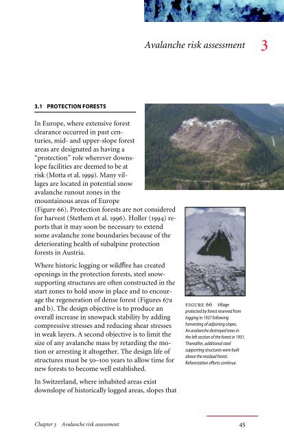
3.1 PROTECTION FORESTS<br />
In Europe, where extensive forest<br />
clearance occurred in past centuries,<br />
mid- <strong>and</strong> upper-slope forest<br />
areas are designated as having a<br />
“protection” role wherever downslope<br />
facilities are deemed to be at<br />
<strong>risk</strong> (Motta et al. 1999). Many villages<br />
are located in potential snow<br />
avalanche runout zones in the<br />
mountainous areas <strong>of</strong> Europe<br />
(Figure 66). Protection forests are not considered<br />
for harvest (Stethem et al. 1996). Holler (1994) reports<br />
that it may soon be necessary to extend<br />
some avalanche zone boundaries because <strong>of</strong> the<br />
deteriorating health <strong>of</strong> subalpine protection<br />
forests in Austria.<br />
Where historic logging or wildfire has created<br />
openings in the protection forests, steel snowsupporting<br />
structures are <strong>of</strong>ten constructed in the<br />
start zones to hold snow in place <strong>and</strong> to encourage<br />
the regeneration <strong>of</strong> dense forest (Figures 67a<br />
<strong>and</strong> b). The design objective is to produce an<br />
overall increase in snowpack stability by adding<br />
compressive stresses <strong>and</strong> reducing shear stresses<br />
in weak layers. A second objective is to limit the<br />
size <strong>of</strong> any avalanche mass by retarding the motion<br />
or arresting it altogether. The design life <strong>of</strong><br />
structures must be 50–100 years to allow time for<br />
new forests to become well established.<br />
In Switzerl<strong>and</strong>, where inhabited areas exist<br />
downslope <strong>of</strong> historically logged areas, slopes that<br />
<strong>Avalanche</strong> <strong>risk</strong> <strong>assessment</strong> 3<br />
figure 66 Village<br />
protected by forest reserved from<br />
logging in 1937 following<br />
harvesting <strong>of</strong> adjoining slopes.<br />
An avalanche destroyed trees in<br />
the left section <strong>of</strong> the forest in 1951.<br />
Thereafter, additional steel<br />
supporting structures were built<br />
above the residual forest.<br />
Reforestation efforts continue.<br />
Chapter 3 <strong>Avalanche</strong> <strong>risk</strong> <strong>assessment</strong> 45
ange from 30° to 50° are generally considered to warrant avalanche-inhibiting<br />
structures. Structures are constructed up to the elevation <strong>of</strong> the<br />
highest expected fracture line. Continuous lines <strong>of</strong> structures are constructed<br />
across the slope 20–50 m apart. The height <strong>of</strong> a structure is<br />
critical for long-term protection, so detailed snow accumulation studies<br />
are undertaken as a part <strong>of</strong> each design. The criteria for design <strong>of</strong> the vertical<br />
height <strong>of</strong> structures is that they must<br />
correspond to at least the 100-year return period<br />
snow depth. Typical structure heights used in the<br />
Swiss Alps are 3 m, 3.5 m, <strong>and</strong> 4 m (Margreth 1996).<br />
Trees are planted between <strong>and</strong> below static defence<br />
structures.<br />
a) A network <strong>of</strong> rigid snow-supporting<br />
structures installed to resist snow<br />
avalanche initiation.<br />
b) Slab avalanche initiation in area not<br />
protected with defence structures.<br />
figure 67 <strong>Avalanche</strong> start zone<br />
defence structures.<br />
figure 68 Snow support<br />
structures built in an opening above a<br />
subdivision, Big Sky, Montana. Forest is<br />
slowly regrowing between the structures.<br />
Such works require pr<strong>of</strong>essional<br />
engineering design in British Columbia.<br />
The Swiss Federal Institute for Snow <strong>and</strong><br />
<strong>Avalanche</strong> Research has published st<strong>and</strong>ard design<br />
specifications in the Guidelines for <strong>Avalanche</strong> Protection<br />
Utilizing Structures in the Starting Zone<br />
(1990). Installed costs can be <strong>of</strong> the order <strong>of</strong> 1 million<br />
Swiss francs per hectare (equivalent to about<br />
Can. $1 million/ha assuming similar construction<br />
costs). Switzerl<strong>and</strong> currently spends 40–50 million<br />
Swiss francs annually on afforestation <strong>and</strong> associated<br />
structural measures for avalanche protection<br />
(Margreth 2000).<br />
In North America, engineered supporting structures<br />
have been employed on very small avalanche<br />
paths where property has been placed at <strong>risk</strong> by<br />
logging (Figure 68).<br />
Where life <strong>and</strong> buildings are potentially at <strong>risk</strong>, sensible<br />
l<strong>and</strong> use planning in the runout zone will<br />
<strong>of</strong>ten be a much more cost-effective solution than<br />
trying to retain snow on open or harvested slopes.<br />
In many cases, it will be cheaper to relocate<br />
dwellings or realign a road rather than trying to<br />
protect against avalanches <strong>of</strong> Size 3 or greater. The<br />
proposed national st<strong>and</strong>ard for avalanche hazard<br />
mapping in Canada (McClung et al. 2002) stresses<br />
the protective role that forests can play.<br />
46 Snow <strong>Avalanche</strong> Management in Forested Terrain
Wildfire or logging on steep slopes in areas <strong>of</strong> high snow supply can create<br />
openings that avalanche so frequently that regeneration is exceedingly<br />
slow. In the Rogers Pass area, forest burnt over 100 years ago has not regrown<br />
beyond a sparse cover because <strong>of</strong> regular disturbance by snow<br />
avalanches (Figure 69).<br />
<strong>Avalanche</strong>s in British Columbia <strong>Forests</strong><br />
In the Interior Cedar-Hemlock (ich) zone <strong>of</strong><br />
British Columbia, it has been estimated that<br />
avalanche initiation may be suppressed if the st<strong>and</strong><br />
density in potential start zones exceeds 1000 stems<br />
per hectare once the mean diameter at breast height<br />
(dbh) exceeds 12–15 cm. (However, there are no<br />
known surveys that confirm this opinion.)<br />
Projected st<strong>and</strong> information can be <strong>of</strong> value when<br />
considering the long-term avalanche <strong>risk</strong> associated<br />
with forest harvesting. A block’s site index (a measure<br />
<strong>of</strong> optimum tree growth at the 50-year age<br />
class) is largely dependent on elevation, aspect, <strong>and</strong><br />
soil type (Thrower et al. 1991), <strong>and</strong> can be used to<br />
predict rate <strong>of</strong> regrowth following replanting<br />
(Figure 70).<br />
It is suggested that the reduction in avalanche potential<br />
in regenerating forests is due primarily to the<br />
effect <strong>of</strong> the canopy projecting above the snow surface,<br />
which alters the energy balance <strong>and</strong> layering <strong>of</strong><br />
the snowpack. Reduction or elimination <strong>of</strong> processes<br />
that promote surface hoar formation are critical in<br />
figure 69 Dense forest<br />
that originally extended to the<br />
ridgetop west <strong>of</strong> Rogers Pass was<br />
probably destroyed by fire when<br />
the railway was built in 1885. The<br />
original railway track was at the<br />
bottom <strong>of</strong> the slope. Construction<br />
crews <strong>of</strong> the era <strong>of</strong>ten set the forest<br />
on fire to clear the area. Forest not<br />
burnt during construction <strong>of</strong>ten<br />
caught fire later from sparks<br />
released by steam engines.<br />
the Columbia Mountains in particular. Mechanical reinforcement on the<br />
snowpack by trees is considered to be a secondary effect.<br />
Successful forest re-establishment will, in the great majority <strong>of</strong> cases,<br />
eliminate the <strong>risk</strong> <strong>of</strong> further avalanches. <strong>Avalanche</strong> initiation is considered<br />
to be less likely when tree heights are greater than three times the<br />
maximum snow depth. Destructive avalanches start in st<strong>and</strong>ing<br />
timber only in exceptional circumstances. Conversely, the occurrence <strong>of</strong><br />
one Size 4 avalanche may lead to permanent site degradation (soil loss)<br />
<strong>and</strong> inhibit forest regeneration.<br />
Interpretation <strong>of</strong> the output <strong>of</strong> the forest growth modelling scenario in<br />
Figure 72 suggests that the avalanche potential will decrease markedly at<br />
Chapter 3 <strong>Avalanche</strong> <strong>risk</strong> <strong>assessment</strong> 47
a)<br />
dbh (cm) Height (m)<br />
b)<br />
dbh (cm) Height (m)<br />
40<br />
30<br />
20<br />
30–50 years after replanting, provided that no avalanches damage restocked<br />
areas in the interim.<br />
1200<br />
1100<br />
1000<br />
10<br />
900<br />
0<br />
0 10 20 30 40 50 60 70<br />
Height m<br />
dbh cm<br />
stem/ha<br />
800<br />
80 90 100<br />
40<br />
30<br />
20<br />
10<br />
Site index = 25<br />
Age (years)<br />
Site index = 10<br />
1200<br />
1100<br />
1000<br />
900<br />
0<br />
0 10 20 30 40 50 60 70<br />
Height m<br />
dbh cm<br />
stem/ha<br />
800<br />
80 90 100<br />
Age (years)<br />
figure 70 Projections from TIPSY growth model (B.C. <strong>Ministry</strong><br />
<strong>of</strong> <strong>Forests</strong> 1997). Curves are for a) a typical ICH valley floor site<br />
<strong>and</strong> b) a near-timberline site (site indices <strong>of</strong> 25 <strong>and</strong> 10, respectively).<br />
figure 71 Small avalanches<br />
may run regularly in long narrow<br />
gullies, but theses events are unlikely to<br />
have enough mass to cause significant<br />
damage or resource loss.<br />
St<strong>and</strong> density (stems/ha)<br />
St<strong>and</strong> density (stems/ha)<br />
3.2 AVALANCHE RISK<br />
CLASSIFICATION<br />
Forestry work in British Columbia<br />
typically uses a simple engineering<br />
<strong>risk</strong> model whereby hazard <strong>and</strong><br />
consequence are independently<br />
evaluated. “Hazard” is defined as<br />
the likelihood, or probability, <strong>of</strong> an<br />
event (MoF Forest Road Engineering<br />
Guidebook 2001; l<strong>and</strong>slide <strong>risk</strong><br />
chapter). <strong>Avalanche</strong> technicians in<br />
the province underst<strong>and</strong> “hazard”<br />
to mean the potential to inflict<br />
death, injury, or loss to people or<br />
to the environment. Unless recognized,<br />
this difference in definition<br />
<strong>of</strong> “hazard” may lead to confusion<br />
when discussions are conducted<br />
between experts from forestry <strong>and</strong><br />
avalanche disciplines.<br />
Risk Assessment<br />
The proposed Canadian national<br />
avalanche <strong>risk</strong> st<strong>and</strong>ard quantifies<br />
<strong>risk</strong> as the combination <strong>of</strong><br />
avalanche frequency <strong>and</strong> magnitude<br />
(McClung [2002]). In the forest sector,<br />
avalanche <strong>risk</strong> <strong>assessment</strong>s are required to address:<br />
• Long-term (or spatial) problems, where the concern<br />
relates to prediction <strong>of</strong> future avalanche<br />
susceptibility (e.g., where an avalanche start<br />
zone might be created by forest harvesting or<br />
fire, at some time in the future, on previously<br />
unaffected terrain).<br />
• Short-term (or temporal) problems, where the<br />
48 Snow <strong>Avalanche</strong> Management in Forested Terrain
dbh (cm) Height (m)<br />
25<br />
20<br />
15<br />
10<br />
5<br />
Height m<br />
dbh cm<br />
<strong>Avalanche</strong> potential<br />
0<br />
0 10 20 30 40 50 60 70 80 90<br />
0<br />
100<br />
Age (years)<br />
concern relates with real-time avalanche <strong>assessment</strong><br />
<strong>and</strong> forecasting in recognized avalanche<br />
terrain. Public <strong>and</strong> worker safety, <strong>and</strong> resource<br />
protection, are key issues.<br />
In this h<strong>and</strong>book, the term “likelihood” is defined as<br />
an “expert’s degree <strong>of</strong> belief” that an event will occur<br />
in a specified time period, given various data <strong>and</strong><br />
site-specific information (Edwards 1992, p. 9; Vink<br />
1992; Einstein 1997; McClung 2001a). When assessing<br />
snow avalanche <strong>risk</strong>, an expert will draw on background<br />
knowledge <strong>and</strong> experience, principles <strong>of</strong><br />
1.0<br />
0.9<br />
0.8<br />
0.7<br />
0.6<br />
0.5<br />
0.4<br />
0.3<br />
0.2<br />
0.1<br />
figure 72 Conceptual model <strong>of</strong> avalanche susceptibility in a regenerating opening in steep terrain with<br />
regular, high snow supply. Note that the precise shape <strong>of</strong> the “avalanche susceptibility” curve (dotted line)<br />
cannot be defined at this time. Tree height <strong>and</strong> dbh modelled for an ICH st<strong>and</strong> planted at 1400 stems/ha with<br />
site index 13; typical midslope cutblock regrowth. (Projected dbh <strong>and</strong> height from TIPSY growth model, B.C.<br />
<strong>Ministry</strong> <strong>of</strong> <strong>Forests</strong> 1997.)<br />
engineering <strong>and</strong> geoscience, <strong>and</strong> site-specific climate <strong>and</strong> terrain information<br />
to assess the likelihood <strong>of</strong> an avalanche occurrence within a given<br />
spatial <strong>and</strong> temporal setting (Table 11).<br />
Bayes’ theorem may be used in avalanche <strong>risk</strong> <strong>assessment</strong>, to enable<br />
observational information to be combined with pr<strong>of</strong>essional opinion,<br />
quantified as a subjective probability (Wu et al. 1996; Einstein 1997).<br />
Tables 11–13 present an avalanche <strong>risk</strong> <strong>assessment</strong> method that is used to<br />
Chapter 3 <strong>Avalanche</strong> <strong>risk</strong> <strong>assessment</strong> 49<br />
<strong>Avalanche</strong> susceptibility<br />
figure 73 Damage in a<br />
regenerating cutblock from a small<br />
avalanche that initiated in a clearcut<br />
above. Many similar small events go<br />
unnoticed each winter.
ate the avalanche <strong>risk</strong> prior to harvesting. The <strong>assessment</strong> equation has<br />
the form: <strong>risk</strong> = (frequency) × (magnitude [i.e. expected damage]).<br />
At the l<strong>and</strong>scape level, the key question to address in the Forest Development<br />
Plan is whether snow avalanches will initiate if clearcut harvesting<br />
is undertaken <strong>and</strong>, if so, what the consequences will be. During the planning<br />
process, it should be possible to locate mainline <strong>and</strong> secondary<br />
roads to minimize the avalanche <strong>risk</strong>. It is recommended that avalanche<br />
frequency be considered over the length <strong>of</strong> time that it will take for a<br />
closed-canopy forest to develop above the height <strong>of</strong> the 30-year maximum<br />
snowpack. That time will depend on the block’s site index.<br />
A detailed <strong>risk</strong> <strong>assessment</strong> should be undertaken during block layout,<br />
ideally as part <strong>of</strong> the terrain stability field <strong>assessment</strong>, before specifications<br />
for the silviculture prescription are completed. <strong>Avalanche</strong> runout<br />
modelling should be undertaken for any downslope element at <strong>risk</strong> (e.g.,<br />
a railway, highway, road, transmission line, fish stream, or water intake<br />
on a stream) <strong>and</strong> an estimate made <strong>of</strong> the vulnerability <strong>of</strong> that facility or<br />
feature. Measures to mitigate avalanche hazards faced by workers in<br />
winter should be addressed during preparation <strong>of</strong> the silviculture prescription.<br />
table 11 Estimate <strong>of</strong> avalanche likelihood from site-specific observations <strong>and</strong> analysis <strong>of</strong> climate data<br />
Frequency<br />
range Annual<br />
(one event avalanche<br />
Likelihood in period) frequency Description<br />
Near certain < 3 years 1:1 The event will probably occur in most<br />
circumstances.<br />
Likely 3–30 years 1:10 The event should occur at some time<br />
(highly likely in a human lifetime).<br />
Unlikely 30–300 years 1:100 The event may occur at some time<br />
(unlikely in a human lifetime).<br />
The <strong>risk</strong> analysis matrices presented in Tables 12 <strong>and</strong> 13 can be used to<br />
rank both short- <strong>and</strong> long-term <strong>risk</strong>, but different management responses<br />
are appropriate, as recommended in Table 4.<br />
Assessing Risk to Forest Cover<br />
To prevent damage to the forest cover, the recommended acceptable <strong>risk</strong><br />
is a Size 3 avalanche with an average frequency <strong>of</strong> less than 1:10 years, or a<br />
Size 2 avalanche with an average frequency <strong>of</strong> less than 1:1 years. The <strong>risk</strong><br />
50 Snow <strong>Avalanche</strong> Management in Forested Terrain
matrices below are constructed on the basis <strong>of</strong> three orders <strong>of</strong> magnitude,<br />
avalanche frequency, <strong>and</strong> consequences rated qualitatively (proportionally<br />
to the <strong>risk</strong>). Risk <strong>of</strong> damage to forest cover is rated as low (L), moderate<br />
(M), <strong>and</strong> high (H).<br />
table 12 Risk ratings for expected avalanche size <strong>and</strong> expected avalanche frequency for forest harvest resulting in<br />
damage to forest cover (source: McClung [2002]). Risk is rated qualitatively as low (L), moderate (M), <strong>and</strong><br />
high (H)<br />
Frequency Average Qualitative <strong>risk</strong> for avalanche size<br />
range (events/yr) frequency (events/yr) 2 3 > 3<br />
>1–1:3 1:1 M H H<br />
1:3–1:30 1:10 L M a H<br />
1:30–1:300 1:100 L L H<br />
a The proposed Canadian national avalanche <strong>risk</strong> st<strong>and</strong>ard for forest harvesting (Size 3 with 10year<br />
return period; bolded), is considered to be on the border between moderate <strong>and</strong> high<br />
<strong>risk</strong> (McClung et al. 2002). However, due to uncertainty in the estimate, other categories<br />
have the same moderate <strong>risk</strong> rating. Moderate <strong>risk</strong> will normally warrant modification <strong>of</strong> the<br />
harvest design.<br />
Notes:<br />
• For damage to forest cover, the <strong>risk</strong> is nominal for avalanches <strong>of</strong> less than Size 2 (see p. 19 for<br />
avalanche size definitions).<br />
• <strong>Avalanche</strong>s <strong>of</strong> Size 4 or larger are unacceptable at any return period following logging. Size 4<br />
avalanches initiating in cutblocks can create permanent new avalanche terrain by degrading<br />
soil <strong>and</strong> vegetative cover, which is unacceptable in an environmental st<strong>and</strong>ard. Size 4 avalanches<br />
may introduce significant amounts <strong>of</strong> soil, rocks, <strong>and</strong> logs to stream channels. The effects<br />
may be similar to large debris flows.<br />
• Frequent Size 2 avalanches can damage small seedlings <strong>and</strong> branches during regeneration. This,<br />
with the inherent uncertainty associated with the field estimation, produces moderate <strong>risk</strong> for<br />
annual avalanches (1:1).<br />
• There may be additional site-specific instances where a Size 2 avalanche, at a 1 year in 10 return<br />
period, may pose <strong>risk</strong> to downslope or in-stream values, such as critical fish spawning reaches<br />
or locations where a stream blockage or avulsion is likely. In such instances the <strong>risk</strong> may be<br />
revised upwards, based on pr<strong>of</strong>essional judgement.<br />
Assessing Risk above Transportation Corridors, Facilities, or<br />
Essential Resources<br />
When downslope transportation corridors (e.g., highways or railways),<br />
facilities (e.g., occupied or unoccupied structures), essential resources<br />
(e.g., registered community, domestic, or commercial watersheds or<br />
important fisheries), or other concerns may be affected by avalanche<br />
initiation from logging, the acceptable <strong>risk</strong> must be more conservative<br />
than if timber resources alone are affected. For this application, the recommended<br />
acceptable <strong>risk</strong> is a Size 3 avalanche with an average frequency<br />
Chapter 3 <strong>Avalanche</strong> <strong>risk</strong> <strong>assessment</strong> 51
<strong>of</strong> less than 1:30 years, or a Size 2 avalanche with an average frequency <strong>of</strong><br />
less than 1:3 years. Table 13 shows the applicable <strong>risk</strong> matrix analogous to<br />
Table 12 for timber resources.<br />
table 13 Risk ratings for expected avalanche size <strong>and</strong> frequency for forest harvest when downslope transportation<br />
corridors, facilities, or essential resources may be affected (source: McClung [2002]) Risk is rated qualitatively<br />
as low (L), moderate (M), <strong>and</strong> high (H)<br />
Frequency Average Qualitative <strong>risk</strong> for avalanche size<br />
range (events/yr) frequency (events/yr) 2 3 > 3<br />
>1–1:10 1:3 M H H<br />
1:10–1:100 1:30 L M a H<br />
table 14 Examples <strong>of</strong> <strong>risk</strong> management strategies<br />
Appropriate <strong>risk</strong> management strategy<br />
Protection <strong>of</strong> forest resources<br />
Level Risk Protection <strong>of</strong> environment Public <strong>and</strong> operational safety issues<br />
H High Avoid development or forest Risk to forest workers, downslope<br />
harvesting. Mitigation or remedi- transmission <strong>and</strong> transportation<br />
ation usually too expensive corridors, or residents is unaccompared<br />
to economic returns. ceptable. Avoid.<br />
M Moderate Qualified registered pr<strong>of</strong>essional Responsibility for snow stability<br />
to assess avalanche <strong>risk</strong> during <strong>and</strong> avalanche danger should be<br />
a terrain stability field assess- clearly specified. Senior management<br />
by estimation <strong>of</strong> destructive ment committed to development<br />
potential <strong>and</strong> return interval <strong>of</strong> <strong>and</strong> maintenance <strong>of</strong> avalanche<br />
avalanches at point <strong>of</strong> interest. safety program. Temporary shut<br />
Elements at <strong>risk</strong> identified <strong>and</strong> down procedures accepted as part<br />
their vulnerability evaluated. <strong>of</strong> work program. Risk may be<br />
Modification <strong>of</strong> clearcut harvest- avoided by scheduling harvesting<br />
ing prescriptions developed to for summer. Experienced<br />
reduce likelihood <strong>of</strong> avalanche avalanche technician with caa<br />
initiation or lateral or lineal exten- Level 2 qualification retained to<br />
sion <strong>of</strong> existing avalanche paths. implement efficient avalanche<br />
Roads <strong>and</strong> bridges relocated. control <strong>and</strong> closures.<br />
L Low Quantify <strong>and</strong> accept the <strong>risk</strong>. Manage <strong>risk</strong> by st<strong>and</strong>ard occupational<br />
health <strong>and</strong> safety regulations<br />
<strong>and</strong> safe work procedures.<br />
Risk Management Strategies<br />
Risk management strategies <strong>of</strong>ten draw a distinction<br />
between:<br />
• High Likelihood – Low Consequence events<br />
<strong>and</strong><br />
• Low Likelihood – High Consequence events<br />
Different <strong>risk</strong> management responses are <strong>of</strong>ten warranted<br />
for each <strong>of</strong> the combinations (Strahlendorf<br />
1998) (Table 15).<br />
figure 74 Any avalanche<br />
originating in this cutblock will be <strong>of</strong> low<br />
consequence with respect to the timber<br />
resource but the consequences for traffic<br />
hit by an avalanche on the road will be<br />
very high because <strong>of</strong> the water body<br />
below.<br />
Chapter 3 <strong>Avalanche</strong> <strong>risk</strong> <strong>assessment</strong> 53
table 15 Appropriate <strong>risk</strong> responses (source: Elms 1998)<br />
Consequence<br />
Likelihood High Low<br />
High Avoid or reduce <strong>risk</strong> Adopt quality safety<br />
management systems<br />
Low Treat very carefully<br />
Reduce consequence<br />
Accept <strong>risk</strong><br />
The avalanche <strong>risk</strong> on snow-covered slopes over 60% can seldom, if ever,<br />
be reduced to zero (Figure 75). Whenever <strong>risk</strong> is judged to be excessive,<br />
reduction strategies generally adopt the “alarp” principle: the residual<br />
<strong>risk</strong> should be “As Low As is Reasonably Practicable” (Canadian St<strong>and</strong>ards<br />
Association 1997; Keey 2000). Fell <strong>and</strong> Hartford (1997) distinguish<br />
between <strong>risk</strong> tolerability <strong>and</strong> acceptability for developments in British<br />
Columbia.<br />
Intolerable region<br />
ALARP –<br />
"As low as is<br />
reasonably practicable" –<br />
Risk only taken if<br />
a benefit is desired<br />
Broadly acceptable region<br />
Total<br />
<strong>risk</strong><br />
Risk cannot be justified on<br />
any grounds<br />
Tolerable only if <strong>risk</strong><br />
reduction is<br />
impracticable<br />
Tolerable if cost <strong>of</strong><br />
reduction would exceed<br />
the improvement gained<br />
Negligible <strong>risk</strong><br />
figure 75 ALARP framework for <strong>risk</strong> <strong>assessment</strong> <strong>and</strong> reduction. (After Canadian St<strong>and</strong>ards Association 1997,<br />
p. 25; Morgan 1997)<br />
54 Snow <strong>Avalanche</strong> Management in Forested Terrain
Risk management typically involves<br />
six steps (Figure 76). Risk<br />
communication with all stakeholders<br />
is an important part <strong>of</strong> each<br />
step.<br />
Risk <strong>assessment</strong> is regarded as a<br />
continuous iterative process (Figure<br />
77). The monitor <strong>and</strong> review<br />
process is important because<br />
ongoing forest development may<br />
increase the avalanche <strong>risk</strong> over<br />
time. Review gives management<br />
verification as to the success <strong>of</strong> <strong>risk</strong><br />
reduction strategies in use. Continuous<br />
<strong>risk</strong> <strong>assessment</strong> not only<br />
applies to the day-to-day evaluation<br />
<strong>of</strong> snow stability <strong>and</strong><br />
avalanche danger, but also to the<br />
overall avalanche <strong>risk</strong> in an operating<br />
area over time.<br />
Forest managers should watch for<br />
“insidious” <strong>risk</strong>s that may develop<br />
as harvesting moves onto higher,<br />
steeper terrain or, locally, where<br />
steep blocks are harvested above<br />
camps, mills, scales, residential<br />
areas, transportation corridors,<br />
bridges, or power lines.<br />
Once a detailed <strong>risk</strong> <strong>assessment</strong> is complete, an experienced avalanche<br />
practitioner should be consulted to develop a suitable winter safety<br />
program.<br />
Responsibility for Risk Management<br />
<strong>Avalanche</strong> <strong>risk</strong> management is everyone’s responsibility. Risk management<br />
should be integrated <strong>and</strong> owned throughout a company or<br />
operation. A sound objective is to develop a corporate safety culture<br />
above <strong>and</strong> beyond Workers’ Compensation Board requirements. There<br />
should be one, clearly identifiable individual who assesses the overall<br />
situation each day during the avalanche season. That person shall be<br />
Chapter 3 <strong>Avalanche</strong> <strong>risk</strong> <strong>assessment</strong> 55<br />
Risk communication<br />
⇔<br />
⇔<br />
⇔<br />
⇔<br />
⇔<br />
⇔<br />
Establish the context<br />
Identify the <strong>risk</strong> (“what if”)<br />
Analyze the <strong>risk</strong><br />
Assess the <strong>risk</strong><br />
Treat the <strong>risk</strong><br />
Monitor <strong>and</strong> review<br />
figure 76 Steps in the <strong>risk</strong> management decisionmaking<br />
process. (After Canadian St<strong>and</strong>ards Association<br />
1997, p.7; Keey 1998)<br />
Act<br />
Observe<br />
Assess<br />
Analyze<br />
figure 77 Process <strong>of</strong> continuous <strong>risk</strong> <strong>assessment</strong>.<br />
(Elms 1998)
eferred to as the “<strong>of</strong>ficer responsible for avalanche <strong>risk</strong> management.” In<br />
larger organizations, that <strong>of</strong>ficer does not do all the work, but provides<br />
policy <strong>and</strong> advice on setting up <strong>risk</strong> management systems <strong>and</strong> then monitors<br />
what is being done.<br />
An avalanche accident <strong>and</strong> incident log should be maintained to assess<br />
the frequency <strong>of</strong> avalanche hazards encountered in the forest. A proactive<br />
approach to record-keeping will function only if the workers <strong>and</strong> management<br />
view the process in a positive light with an objective <strong>of</strong><br />
improving occupational health <strong>and</strong> safety. Contractors should not be<br />
penalized for tracking or reporting incidents or for making conservative<br />
decisions regarding their own safety.<br />
Accident <strong>and</strong> Incident Logs<br />
It must be recognized that while an incident<br />
<strong>and</strong> accident log can help a forest company<br />
plan its response to the avalanche hazard, it<br />
may fail to give adequate warning if the<br />
operating environment changes. Logging<br />
operations moving into steeper terrain or<br />
higher elevations, or operations that<br />
encounter an unusual combination <strong>of</strong><br />
weather <strong>and</strong> snowpack conditions, may face<br />
an abrupt increase in the avalanche <strong>risk</strong>.<br />
Fatalities<br />
Accidents<br />
Non-injury incidents<br />
figure 78 Typical ratios <strong>of</strong> non-injury industrial<br />
incidents to injurious accidents <strong>and</strong> to fatalities.<br />
Many studies <strong>of</strong> industrial accidents<br />
indicate that a large<br />
number <strong>of</strong> non-injury incidents<br />
are precursors <strong>of</strong> accidents <strong>and</strong><br />
fatalities (Figure 78).<br />
3.3 OWNERSHIP OF RISK IN<br />
FOREST OPERATIONS<br />
It is recommended that an<br />
overview avalanche <strong>risk</strong> <strong>assessment</strong><br />
be undertaken for portions<br />
<strong>of</strong> the operating area, as a part <strong>of</strong><br />
“total chance planning,” where<br />
harvesting is planned for slopes<br />
steeper than 30° (58%), especially<br />
in areas <strong>of</strong> high snow supply.<br />
This may be achievable by a combination<br />
<strong>of</strong> air photo<br />
interpretation, gis analysis, <strong>and</strong><br />
limited field verification. In high<br />
snow supply areas, it is appropriate<br />
for the qualified registered<br />
pr<strong>of</strong>essional to incorporate a<br />
more detailed avalanche <strong>assessment</strong><br />
at the block level as a part<br />
<strong>of</strong> a terrain stability field <strong>assessment</strong>.<br />
56 Snow <strong>Avalanche</strong> Management in Forested Terrain
During the harvest period, forest licensees or their contractors are required<br />
by law to take responsibility for avalanche hazards encountered<br />
during the winter <strong>and</strong> spring period. See Occupational Health <strong>and</strong> Safety<br />
Regulations 26.17 <strong>and</strong> 26.18 (Appendix 1).<br />
With sound <strong>risk</strong> management policies, management<br />
commitment, staff training, <strong>and</strong> safe work procedures<br />
in place, avalanche <strong>risk</strong> can be managed<br />
successfully in winter operations (Figure 79).<br />
At present it is not clear who owns the longer-term<br />
avalanche <strong>risk</strong> posed to downslope resources <strong>and</strong><br />
facilities, especially in relation to logging on private<br />
l<strong>and</strong> in British Columbia (Figure 80). The avalanche<br />
<strong>risk</strong> typically lasts for two or more decades until<br />
regrowth is sufficiently tall <strong>and</strong> dense to reduce the<br />
susceptibility <strong>of</strong> the area to generating large slab<br />
avalanches. In most forest tenures, the licensee’s<br />
responsibility ends when the plantation becomes<br />
“free growing,” which occurs well before avalanche<br />
susceptibility returns to preharvest levels. In a few<br />
cases, soil erosion by snow avalanches may mean<br />
that a forest will be very slow to regrow on newly<br />
formed avalanche paths <strong>and</strong> that the avalanche <strong>risk</strong><br />
may endure for several decades.<br />
3.4 LOGGING ABOVE HIGHWAYS<br />
An interagency protocol, signed in 1992 by the B.C.<br />
<strong>Ministry</strong> <strong>of</strong> Transportation <strong>and</strong> Highways <strong>and</strong> B.C.<br />
<strong>Ministry</strong> <strong>of</strong> <strong>Forests</strong>, exists to minimize instances <strong>of</strong><br />
increased snow avalanche <strong>risk</strong> posed to users <strong>of</strong><br />
highways <strong>and</strong> transportation corridors in the<br />
province (Figures 81–83).<br />
Under the protocol agreement, the <strong>Ministry</strong> <strong>of</strong><br />
<strong>Forests</strong> is obliged to identify proposed cutblocks<br />
with the potential to generate avalanches that may<br />
reach a highway. In addition, the ministry is obligated<br />
to consult with the <strong>Ministry</strong> <strong>of</strong> Transportation<br />
over the licensee’s Forest Development Plan <strong>and</strong><br />
Logging Plan.<br />
figure 79<br />
Managing the avalanche <strong>risk</strong> at a logging<br />
operation at Doctor Creek, southeast B.C.<br />
A yarder is working in the runout zone <strong>of</strong><br />
a series <strong>of</strong> steep avalanche paths to winter<br />
harvest a block immediately below the<br />
photographer. Workers were trained in<br />
avalanche safety <strong>and</strong> rescue, <strong>and</strong> safe<br />
work procedures were implemented.<br />
Daily weather <strong>and</strong> avalanche observations<br />
were made <strong>and</strong> twice-weekly snow<br />
pr<strong>of</strong>ile studies undertaken. Explosives<br />
used under controlled conditions triggered<br />
three avalanches (Size 1 <strong>and</strong> 2)<br />
from the large avalanche path above this<br />
work site.<br />
Chapter 3 <strong>Avalanche</strong> <strong>risk</strong> <strong>assessment</strong> 57
Yarder<br />
Bulldozer<br />
Logging truck<br />
Highway<br />
Wind loading<br />
Loader<br />
figure 80 Winter operations in<br />
potential avalanche terrain on private<br />
l<strong>and</strong> at Enterprise Creek, Slocan Valley.<br />
The gully in which the yarder is working<br />
is likely to be subject to snow loading by<br />
the prevailing wind <strong>and</strong> may be prone<br />
to avalanching. Workers in the area<br />
may be at considerable <strong>risk</strong> unless daily<br />
snow stability evaluations are<br />
undertaken <strong>and</strong> safe work procedures<br />
are adopted. <strong>Avalanche</strong>s from this path<br />
may pose a hazard to the travelling<br />
public on the highway below for two or<br />
three decades following harvest.<br />
figure 82 <strong>Avalanche</strong>s<br />
initiating in the steep harvested<br />
terrain above the Trans-Canada<br />
Highway in the Kicking Horse<br />
Canyon have the potential to affect<br />
the highway even though the area is<br />
not <strong>of</strong>ten subject to deep snowpacks.<br />
figure 81 Steep terrain in a recently harvested cutblock on private l<strong>and</strong> above<br />
Enterprise Creek may produce avalanches that run onto Highway 6. Who owns the <strong>risk</strong>?<br />
Risk Management Objectives<br />
To minimize <strong>risk</strong>, the potential for logged slopes to avalanche<br />
must be addressed when planning a timber harvest.<br />
The following benchmarks are <strong>of</strong>fered as <strong>risk</strong> management<br />
objectives. The objectives acknowledge that there is residual<br />
<strong>risk</strong> associated with avalanche forecasting <strong>and</strong> control. The<br />
objectives are not intended to replace Workers’ Compensation<br />
Board regulations (Appendix 1), which require due diligence<br />
<strong>and</strong> a high st<strong>and</strong>ard <strong>of</strong> care.<br />
1. Workers on foot should not be put at <strong>risk</strong> <strong>of</strong> being involved<br />
with avalanches that could cause burial or injury.<br />
Objective: No avalanches greater than Size 1.5.<br />
2. Workers in trucks, industrial, or maintenance equipment<br />
should not be put at <strong>risk</strong> <strong>of</strong> being involved with avalanches<br />
that could damage a pick-up truck.<br />
Objective: No avalanches greater than Size 2.5.<br />
3. <strong>Avalanche</strong>s <strong>of</strong> any size, resulting from explosive-based<br />
avalanche control should never run out onto a forest road<br />
or highway that is open to the public or industrial traffic, or<br />
onto occupied l<strong>and</strong>.<br />
4. <strong>Avalanche</strong>s triggered with explosives should, at most, cause<br />
only minimal damage to trees or minimal soil loss in or<br />
below any cutblock.<br />
Objective: No avalanches greater than Size 2.5.<br />
Note: No objective can be set for consequences <strong>of</strong> avalanche<br />
control undertaken in existing paths where natural avalanches<br />
have previously affected the forest.<br />
These objectives were developed in consultation with<br />
participants <strong>of</strong> a workshop held in Revelstoke on March 16,<br />
2000. Refer to Table 4 for details <strong>of</strong> the Canadian avalanche<br />
size classification system.<br />
58 Snow <strong>Avalanche</strong> Management in Forested Terrain
Two criteria are defined in the protocol by the <strong>Ministry</strong><br />
<strong>of</strong> Transportation’s Snow <strong>Avalanche</strong> Program:<br />
• Maximum winter snowpack is greater than 0.5 m<br />
(a return period is not defined)<br />
• Sighted angle from road to the top <strong>of</strong> block is<br />
greater than 25° (47%)<br />
Foresters <strong>and</strong> consultants who undertake harvest<br />
planning <strong>and</strong> cutblock layout work in avalancheprone<br />
terrain above highways or other facilities<br />
should consider the protocol methodology (Figure 84).<br />
An algorithm can readily be implemented in a geographic<br />
information system to identify potential<br />
areas <strong>of</strong> concern above public highways, railways,<br />
power transmission lines, or inhabited areas. A<br />
qualified registered pr<strong>of</strong>essional should undertake<br />
on-site avalanche <strong>assessment</strong> <strong>and</strong> calculate the<br />
avalanche runout potential as a part <strong>of</strong> a detailed<br />
Terrain Stability Field Assessment for proposed cutblocks.<br />
A <strong>risk</strong> analysis should be undertaken for<br />
cutblocks that have the potential to reach the highway<br />
(see Table 13). The analysis should consider the<br />
exposure <strong>and</strong> vulnerability <strong>of</strong> persons or facilities.<br />
If the angle from<br />
the highway to top <strong>of</strong><br />
cutblock is greater than 25°<br />
then the Forest Development<br />
Plan must be referred to Snow<br />
<strong>Avalanche</strong> Programs – <strong>Ministry</strong><br />
<strong>of</strong> Transportation <strong>and</strong> Highways.<br />
A detailed avalanche <strong>assessment</strong><br />
may be required.<br />
If the angle from the Highway to top <strong>of</strong><br />
cutblock is less than 25°, there is no need<br />
to refer the Forest Development Plan to<br />
Snow <strong>Avalanche</strong> Programs – <strong>Ministry</strong><br />
<strong>of</strong> Transportation <strong>and</strong> Highways.<br />
top <strong>of</strong> cutblock<br />
figure 83 Harvesting was proposed<br />
in an even-aged pine forest along Highway<br />
3 west <strong>of</strong> Castlegar, where red trees indicate<br />
insect attack. Inspection <strong>of</strong> the steep open<br />
talus slopes above the highway showed<br />
that avalanches impact the upper edge <strong>of</strong><br />
the forest. Runout modelling indicated that<br />
avalanches initiating at the top <strong>of</strong> the steep<br />
open slopes <strong>and</strong> running on a smooth snow<br />
surface (e.g., where stumps <strong>and</strong> logging<br />
slash are buried by a deep winter snowpack)<br />
could reach the highway. Snow supply in<br />
the area is moderate. The south-facing<br />
aspect makes wet avalanches probable in<br />
spring. A <strong>risk</strong> analysis was undertaken to<br />
estimate the likelihood <strong>and</strong> expected<br />
frequency with which avalanches might<br />
reach the road edge. Mitigative measures<br />
proposed included retention <strong>of</strong> a timber<br />
buffer. Foresters then had to evaluate the<br />
potential for retained trees to succumb to<br />
insect attack.<br />
Snow <strong>Avalanche</strong> Program<br />
<strong>Ministry</strong> <strong>of</strong> Transportation<br />
Diagram 1.0: Guidelines for <strong>Avalanche</strong><br />
Slope Assessment <strong>and</strong> Referral<br />
Example 1: The angle from highway to<br />
top <strong>of</strong> cutblock is 33°. In this<br />
case, the Logging Plan must<br />
be referred to Snow<br />
<strong>Avalanche</strong> Programs –<br />
MoTH.<br />
Example 2: The angle from highway<br />
to top <strong>of</strong> cutblock is 24°<br />
<strong>and</strong> therefore, no<br />
avalanche <strong>assessment</strong><br />
would be referred to<br />
MoTH.<br />
figure 84 Method used by MoF <strong>and</strong> MoT to identify proposed harvest blocks that may generate snow avalanches<br />
that could run out on public highways (25° = 47%). (Note: Protocol may be subject to revision. The term “logging plan” is now<br />
obsolete; the Forest Development Plan should be referred to the <strong>Ministry</strong> <strong>of</strong> Transportation.)<br />
Chapter 3 <strong>Avalanche</strong> <strong>risk</strong> <strong>assessment</strong> 59<br />
33°<br />
24°<br />
Highway
table 16 Mapping methods that may be applicable for use in snow avalanche–prone terrain (after Gerath et al. 1996)<br />
Name Example Strengths <strong>and</strong> weaknesses <strong>of</strong> method<br />
a Event <strong>Avalanche</strong> atlas • Objective <strong>and</strong> qualitative<br />
Distribution (Fitzharris <strong>and</strong> • Creates a useful database <strong>of</strong> existing<br />
Analysis Owens 1983) avalanche paths<br />
• Does not predict likelihood <strong>of</strong> new start<br />
zones being formed in harvested terrain<br />
b Event Inventory map drawn • Objective <strong>and</strong> qualitative<br />
Activity from a series <strong>of</strong> old • Creates a useful database <strong>of</strong> avalanche<br />
Analysis air photos or from paths. Documents activity at different<br />
avalanche observation time periods<br />
database • Does not predict likelihood <strong>of</strong> new<br />
paths being formed in harvested terrain<br />
c Event Mapping <strong>of</strong> paths per • Objective <strong>and</strong> qualitative<br />
Density unit l<strong>and</strong> area (km2 ); • Creates a useful database <strong>of</strong> avalanche<br />
Analysis “susceptibility” mapping paths. Some predictive value<br />
• Does not account for snow supply gradients<br />
caused by orographic enhancement<br />
<strong>of</strong> precipitation<br />
d Subjective Polygon-based mapping; • Subjective, qualitative, <strong>and</strong> flexible<br />
Geomorphic interpretation <strong>of</strong> slope, • Terrain stability/avalanche hazard class<br />
Analysis elevation, aspect, l<strong>and</strong> criteria are <strong>of</strong>ten unspecified<br />
form <strong>and</strong> length <strong>of</strong> fetch; • Requires expert skill <strong>and</strong> judgement<br />
French “Probable • Creates a useful database <strong>of</strong> avalanche<br />
avalanche location” maps paths <strong>and</strong> some terrain attributes<br />
(Borrel 1992) • Difficult to review<br />
e Subjective Likelihood mapping; • Subjective <strong>and</strong> qualitative to semi-<br />
Rating Hazard rating algo- quantitative. Flexible<br />
Analysis rithms are developed • Specified terrain stability/avalanche<br />
for local areas <strong>and</strong> hazard classification criteria are <strong>of</strong>ten<br />
applied via GIS unspecified<br />
(Kelly et al. 1997) • Requires skill <strong>and</strong> judgement <strong>of</strong> an<br />
avalanche expert<br />
• Work can be delegated <strong>and</strong> checked.<br />
• Creates a useful database <strong>of</strong> many<br />
relevant terrain attributes<br />
• May present danger <strong>of</strong> oversimplification<br />
f Relative Mapping based on • Objective <strong>and</strong> qualitative to semi-<br />
Univariate statistically significant quantitative<br />
Analysis correlation <strong>of</strong> slope • Relatively statistically based<br />
angle with avalanche • Shows effect <strong>of</strong> individual terrain<br />
occurrence attributes<br />
• Data- <strong>and</strong> analytically intensive<br />
• Relies on quality data<br />
60 Snow <strong>Avalanche</strong> Management in Forested Terrain
table 16 Continued<br />
Name Example Strengths <strong>and</strong> weaknesses <strong>of</strong> method<br />
g Probabilistic No known examples • Objective <strong>and</strong> quantitative<br />
Univariate • Probabilistic–statistically based<br />
Analysis • Simple to implement <strong>and</strong> test<br />
• Danger <strong>of</strong> selection <strong>of</strong> wrong terrain<br />
attributes<br />
• Data- <strong>and</strong> analytically intensive<br />
• Relies on quality data<br />
h Probabilistic Mapping based on • Objective, <strong>and</strong> quantitative, precise<br />
Multivariate statistically significant • Probabilistic–statistically based<br />
Analysis correlation <strong>of</strong> several • Danger <strong>of</strong> selection <strong>of</strong> wrong terrain<br />
terrain variables (slope attributes<br />
angle, elevation, aspect) • Removes experience <strong>and</strong> judgement <strong>of</strong><br />
with avalanche occurrence mapper<br />
• Relies on high-quality data<br />
• Analytically intensive<br />
i Slope Stochastic modelling • Objective, <strong>and</strong> quantitative, precise<br />
Stability using Monte Carlo • Can be reviewed<br />
Analysis simulations; • Difficult to use for mapping a large<br />
factor <strong>of</strong> safety approach area<br />
(Conway <strong>and</strong> Wilbour • Shows influence <strong>of</strong> terrain attributes<br />
1999; Conway et al. 2000) • Requires precise estimates <strong>of</strong> slope<br />
geometry, snow strength properties,<br />
<strong>and</strong> weather conditions<br />
• May not be process driven<br />
• Danger <strong>of</strong> oversimplification<br />
j Hazard Consequence mapping • Subjective <strong>and</strong> qualitative<br />
Consequence • Simple; no separate mapping required<br />
• Runout characteristics not mapped<br />
k Runout Zone Swiss (red, blue, yellow, • Method can be subjective or objective,<br />
white) zoning maps; qualitative, semi-quantitative, or<br />
Icel<strong>and</strong>ic <strong>risk</strong> maps, quantitative<br />
(Keylock et al. 1999) • Simple to complex delineation <strong>of</strong> <strong>risk</strong><br />
zones<br />
• Practical for planning decisions<br />
l Linear Path Norwegian Geotechnical • Subjective <strong>and</strong> qualitative<br />
Movement Institute mapping • Suited to linear movement<br />
(Lied et al. 1989) • Field-intensive <strong>and</strong> analytically<br />
intensive<br />
• Relies on quality data<br />
m Linear Risk Highway avalanche <strong>risk</strong> • Suited to linear transportation<br />
Mapping map (McClung <strong>and</strong> corridors<br />
Navin 2002) • Field-intensive <strong>and</strong> analytically<br />
intensive<br />
• Relies on quality data<br />
Chapter 3 <strong>Avalanche</strong> <strong>risk</strong> <strong>assessment</strong> 61
Where the slope within the proposed block is less than 25° (47%), the<br />
likelihood <strong>of</strong> avalanche initiation may be low or very low, though the<br />
likelihood rises rapidly for slopes above 30° (58%). Alternatives to large<br />
clearcuts may be appropriate in higher-<strong>risk</strong> situations. In some cases, the<br />
<strong>risk</strong> to life <strong>and</strong> limb or potential liability may be too great.<br />
3.5 AVALANCHE MAPPING<br />
Mapping <strong>of</strong> existing avalanche paths is useful for identifying <strong>risk</strong>s to<br />
worker safety, especially on winter access roads. Mapping <strong>of</strong> areas that<br />
have the potential to generate avalanches following timber removal is a<br />
much more difficult task.<br />
Identifying avalanche-prone terrain is a strategic tool for assessing the<br />
long-term <strong>risk</strong> following forest harvesting. At present, there is no widely<br />
accepted method <strong>of</strong> mapping post-harvest avalanche <strong>risk</strong>. The following<br />
discussion gives some ideas <strong>of</strong> possible approaches (see Table 16).<br />
The <strong>Ministry</strong> <strong>of</strong> <strong>Forests</strong> inventory mapping <strong>of</strong> environmentally sensitive<br />
areas (esas) includes snow avalanche susceptibility (esa-Ea). In practice,<br />
esa mapping for avalanche <strong>risk</strong> is seldom used <strong>and</strong> has not been applied<br />
consistently across the province (P. Jordan, MoF, pers. comm.). The<br />
British Columbia terrain classification system presents a classification<br />
<strong>and</strong> a single on-site symbol for snow avalanches (Howes <strong>and</strong> Kenk 1998)<br />
(Appendix 6). To date, most avalanche mapping undertaken in the<br />
province’s forests relates to geomorphic processes as opposed to<br />
avalanche susceptibility or <strong>risk</strong>.<br />
No agreed st<strong>and</strong>ard has been set for avalanche susceptibility mapping<br />
within the province, a situation similar to that existing for terrain mapping<br />
in the 1980s. By contrast, European cartographers have developed a<br />
broad range <strong>of</strong> mapping symbols (e.g., Borrel 1992; Lambert 1992).<br />
Mappers <strong>and</strong> forest managers should review the merits <strong>of</strong> the various<br />
methods listed in Table 16 before initiating major projects. Management<br />
objectives, expectations, <strong>and</strong> outcomes should be carefully defined before<br />
mapping is undertaken. Mapping <strong>of</strong> existing avalanche paths is straightforward;<br />
the challenge is to map the terrain factors that might become<br />
start zones if the forest were removed.<br />
62 Snow <strong>Avalanche</strong> Management in Forested Terrain
Air Photo Interpretation<br />
Oblique colour photographs taken in the spring from fixed-wing aircraft<br />
or helicopters are very useful at the start <strong>of</strong> an investigation into<br />
avalanche activity in an area. Active start zones may become bare much<br />
earlier than adjacent slopes <strong>of</strong> similar aspect because much <strong>of</strong> the snowpack<br />
may be removed by avalanching. By contrast, avalanche deposits<br />
may remain in the valley floor <strong>and</strong> gullies long after the snowline has<br />
receded up a mountain or melted from all but high-elevation, shaded<br />
alpine cirques <strong>and</strong> plateaus.<br />
<strong>Avalanche</strong> mapping projects generally begin with the stereoscopic interpretation<br />
<strong>of</strong> vertical air photographs <strong>and</strong> with the study <strong>of</strong> topographic<br />
maps (Figure 85). The air photo interpreter should have experience in<br />
identifying avalanche start zones <strong>and</strong> tracks in the field <strong>and</strong> have an underst<strong>and</strong>ing<br />
<strong>of</strong> the processes involved in the formation <strong>and</strong> motion <strong>of</strong><br />
avalanches. Inferences made during air photo interpretation should be<br />
figure 85 Stereopair <strong>of</strong> Nagle Creek avalanche path. A low-power pocket stereoscope is required to see the terrain in<br />
three dimensions. Scale approximately 1:15 000 (Airphotos 30 BCB97061 nos. 272 <strong>and</strong> 273).<br />
Chapter 3 <strong>Avalanche</strong> <strong>risk</strong> <strong>assessment</strong> 63
verified in the field. Conclusions should be reached only after one has<br />
taken into account a combination <strong>of</strong> clues <strong>and</strong> considered the interactions<br />
<strong>of</strong> terrain <strong>and</strong> vegetation.<br />
Use <strong>of</strong> air photos at a scale slightly larger than that <strong>of</strong> the finished map is<br />
preferred. Small-scale photos from high-level flights (scale between<br />
1:25 000 <strong>and</strong> 1:80 000) allow the identification <strong>of</strong> paths in avalancheprone<br />
areas <strong>and</strong> the study <strong>of</strong> complete individual paths. Large-scale<br />
photos taken from low-level flights (scale between 1:10 000 <strong>and</strong> 1:25 000)<br />
are best suited for detailed study <strong>of</strong> avalanche start zones, tracks, <strong>and</strong><br />
runout zones. Air photos are usually taken late in the summer when the<br />
area <strong>of</strong> interest is free <strong>of</strong> snow.<br />
Colour photos are helpful when<br />
Small-scale Terrain Features<br />
The forest cover on air photos <strong>of</strong>ten conceals<br />
many small-scale terrain features.<br />
Air photo interpretation <strong>of</strong> potential<br />
avalanche terrain under a forest cover is<br />
unlikely to reveal the details <strong>of</strong> the steepness<br />
<strong>of</strong> the terrain, the slope breaks, the shallow<br />
gullies, the rock bluffs, <strong>and</strong> surface<br />
roughness. These detailed terrain features<br />
may contribute to generating potential<br />
avalanches once the forest cover is removed,<br />
<strong>and</strong> should be assessed in the field.<br />
Examining older, monochrome, vertical air<br />
photos (if available), can give interpreters an<br />
appreciation <strong>of</strong> the growth <strong>and</strong> age <strong>of</strong> the<br />
forest in avalanche paths, which in turn can<br />
lead to inferences about the frequency <strong>of</strong><br />
major avalanche occurrences <strong>and</strong>/or the<br />
degree <strong>of</strong> vegetative recovery.<br />
Field Checking<br />
available, but black-<strong>and</strong>-white<br />
photos are satisfactory.<br />
<strong>Avalanche</strong>s that initiate in the<br />
alpine zones but descend through<br />
the forest are usually obvious.<br />
<strong>Avalanche</strong> start zones located<br />
within the forest cover are less<br />
distinct. However, subtle changes<br />
in the height, grey tone or colour,<br />
<strong>and</strong> density <strong>of</strong> the trees or other<br />
vegetative features can provide<br />
good clues to experienced air<br />
photo interpreters. Short paths,<br />
where avalanches may initiate<br />
from over-steepened road cutbanks<br />
or in small shallow<br />
channels, may not be identifiable<br />
on large-scale vertical air photos.<br />
Air photo interpretations <strong>and</strong> mapping should be field verified at an<br />
appropriate terrain survey intensity level. The Mapping <strong>and</strong> Assessing Terrain<br />
Stability Guidebook (B.C. <strong>Ministry</strong> <strong>of</strong> <strong>Forests</strong> 1999) discusses terrain<br />
survey intensity level in relation to map scale. For 1:5000 to 1:10 000 scale<br />
mapping projects, Ryder (2002) recommends ground checking 75–100%<br />
<strong>of</strong> terrain polygons. For these scales, terrain polygons will be in the order<br />
<strong>of</strong> 2–5 <strong>and</strong> 5–10 ha, respectively.<br />
64 Snow <strong>Avalanche</strong> Management in Forested Terrain
Ortho-rectified, monochrome air photos (orthophotos),<br />
overlain with the B.C. 1:20 000 scale<br />
Terrain Resource Inventory Map (trim) digital<br />
contour data, can be used very effectively with a<br />
planimeter <strong>and</strong> scale rule to determine start zone<br />
<strong>and</strong> runout zone areas, slope angles, <strong>and</strong> lengths <strong>of</strong><br />
avalanche track. <strong>Avalanche</strong> paths outlined on orthophotos<br />
can be digitized <strong>and</strong> the underlying trim<br />
data used to plot longitudinal pr<strong>of</strong>iles <strong>and</strong> to calculate<br />
areas (Figure 86).<br />
Orthophotos overlain with trim contours, enlarged<br />
to 1:10 000 or 1:5000 scale, are useful for marking<br />
positions <strong>and</strong> noting the location <strong>of</strong> small gullies<br />
<strong>and</strong> other features. However, such mapping is no<br />
more accurate than 1:20 000 trim; it is simply easier<br />
to use in the field.<br />
During field inspection, a detailed road survey<br />
should be undertaken. It should focus on specific<br />
features such as steep cutbanks, over-steepened fillslopes,<br />
rock bluffs, gully or other channel crossings,<br />
Elevation (m)<br />
1300<br />
1200<br />
1100<br />
1000<br />
900<br />
800<br />
Fracture line<br />
38° (80%)<br />
Second fracture line at road<br />
36° (74%)<br />
Map Scale<br />
It is important to<br />
recognize the<br />
limitations <strong>of</strong><br />
information<br />
portrayed on maps<br />
in relation to scale.<br />
For example,<br />
1:20 000 TRIM data<br />
<strong>of</strong>ten fail to show<br />
local scale features<br />
such as steep<br />
gullies, rock bluffs,<br />
<strong>and</strong> road cutslopes.<br />
Topographic<br />
mapping at 1:5000<br />
scale should be<br />
commissioned<br />
when working in<br />
high-consequence<br />
areas.<br />
700<br />
600<br />
Nagle Creek<br />
(valley floor)<br />
0 200 400 600 800 1000 1200 1400<br />
Horizontal distance (m)<br />
figure 86 Slope pr<strong>of</strong>ile <strong>of</strong> the Nagle Creek avalanche path plotted from 20-m TRIM contours.<br />
Chapter 3 <strong>Avalanche</strong> <strong>risk</strong> <strong>assessment</strong> 65
<strong>and</strong> existing avalanche path crossings. The road distance (kilometre)<br />
position <strong>of</strong> these important features should also be noted. The location <strong>of</strong><br />
the road with respect to the cutblock (e.g., whether the road traverses the<br />
top, centre, or bottom <strong>of</strong> steep cutblocks). A pocket stereoscope <strong>and</strong> air<br />
photo stereopairs should be taken into the field for reference <strong>and</strong> corroboration.<br />
The Canadian <strong>Avalanche</strong> Association’s Guidelines for <strong>Avalanche</strong> Risk<br />
Determination <strong>and</strong> Mapping in Canada (McClung et al. 2002) <strong>and</strong> a Joint<br />
Practice Board skillset for snow avalanche <strong>assessment</strong>s (jpb 2002) presents<br />
guidance for qualified registered pr<strong>of</strong>essionals carrying out Terrain Stability<br />
Field Assessments in snow avalanche-prone terrain.<br />
<strong>Avalanche</strong> Mapping for L<strong>and</strong> Use Planning<br />
Switzerl<strong>and</strong><br />
In Switzerl<strong>and</strong>, where the observational record <strong>of</strong> avalanche activity<br />
spans many centuries, avalanche mapping incorporates a zoning based<br />
on a calculation <strong>of</strong> impact pressure <strong>and</strong> an estimate <strong>of</strong> return period.<br />
These are:<br />
• High hazard (Red) zone—an area where impact pressures are greater<br />
than 30 kPa, with an annual exceedance probability <strong>of</strong> up to 1 in 300;<br />
or any area likely to be affected by any avalanche with an annual exceedance<br />
probability <strong>of</strong> more than 1 in 30. New buildings <strong>and</strong> winter<br />
parking are prohibited. Existing buildings must be protected <strong>and</strong> evacuation<br />
plans prepared.<br />
• Moderate hazard (Blue) zone—areas affected by flowing avalanches<br />
where the maximum impact pressure is less than 30 kPa, with an annual<br />
exceedance probability <strong>of</strong> 1 in 30 to 1 in 300, or any area likely to<br />
be affected by powder avalanches with impact pressures less than<br />
3 kPa. Public buildings where people may gather should not be constructed.<br />
Special engineering designs are required for private<br />
residences. The area may be closed during periods <strong>of</strong> avalanche danger.<br />
Evacuation plans must be prepared.<br />
• Low hazard (Yellow) zone—an area where flowing avalanches are possible,<br />
with an annual exceedance probability <strong>of</strong> less than 1 in 300 (i.e.,<br />
rare); any area likely to be affected by powder avalanches with impact<br />
pressures <strong>of</strong> less than 3 kPa with an annual exceedance probability <strong>of</strong><br />
less than 1 in 30. Structural defence measures may be recommended.<br />
• No hazard (White) zone—an area where there are no building<br />
restrictions.<br />
66 Snow <strong>Avalanche</strong> Management in Forested Terrain
Gruber <strong>and</strong> Bartelt (2000) describe how the Swiss zoning system performed<br />
when tested by the severe European winter <strong>of</strong> 1999. Deficiencies<br />
in the delineation <strong>of</strong> Yellow zones were noted <strong>and</strong> attributed to the<br />
under-estimation <strong>of</strong> runout distances.<br />
Norway<br />
The Norwegian Geotechnical Institute (ngi) has undertaken overview<br />
mapping <strong>of</strong> avalanche areas (on 1:50 000 scale, 20-m contour interval<br />
base maps) using computer digital terrain modelling techniques (Lied<br />
et al. 1989). Potential start zones are identified as areas steeper than 30°<br />
(58%) <strong>and</strong> not covered in dense forest. Potential avalanche trajectories<br />
are drawn downslope from previously identified start zones by an operator<br />
at a computer workstation. The system computes a longitudinal<br />
pr<strong>of</strong>ile, then calculates the maximum probable avalanche runout distance<br />
based on the alpha <strong>and</strong> beta angle (α <strong>and</strong> β) slope pr<strong>of</strong>ile analysis<br />
method (Lied <strong>and</strong> Toppe 1989; see Figure 30).<br />
All ngi maps are checked against stereopairs <strong>of</strong> vertical air photographs<br />
to verify the reasonableness <strong>of</strong> the modelled runout. The maps are then<br />
field-checked. The maps do not contain any information on avalanche<br />
frequency. No distinction is made between avalanche paths that run once<br />
in 100 years <strong>and</strong> those that may run annually. (Note: Use <strong>of</strong> the alphabeta<br />
model implies an annual probability <strong>of</strong> 1:100.)<br />
The ngi notes that the use <strong>of</strong> 20-m contour base mapping creates an inherent<br />
weakness (in common with trim map data) in that locally steep<br />
slopes with a vertical interval <strong>of</strong> up to 20 m may not be identified.<br />
France<br />
In France, mapping <strong>of</strong> “probable avalanche paths” is undertaken at scale<br />
<strong>of</strong> 1:25 000 (Borrel 1992; Furdada et al. 1995). Conventional avalanche<br />
maps produced by a combination <strong>of</strong> fieldwork <strong>and</strong> air photo interpretation<br />
have been integrated with digital terrain modelling analysis <strong>of</strong><br />
avalanche runout using the ngi’s techniques. The French maps display<br />
the expected maximum runout, but do not contain information on impact<br />
pressure or frequency (Figure 87).<br />
Note: <strong>Avalanche</strong> mapping systems are currently under review in several<br />
European countries, as large avalanches have overrun previously mapped<br />
runout boundaries. Recent avalanche disasters have occurred in both<br />
France <strong>and</strong> Austria (Lambert 2000).<br />
Chapter 3 <strong>Avalanche</strong> <strong>risk</strong> <strong>assessment</strong> 67
figure 87 <strong>Avalanche</strong> mapping for Val d’Isère, France (scale 1:25 000). Mapping in orange is from air photo<br />
interpretation. Mapping in magenta is based on field surveys, interviews with local witnesses including Forest Service<br />
rangers, <strong>and</strong> ski patrollers. Solid cross-hatching implies more certainty than areas delineated with broken cross-hatching.<br />
(After Borrel 1992)<br />
New Zeal<strong>and</strong><br />
<strong>Avalanche</strong> mapping has been completed on many high-use alpine hiking<br />
trails in New Zeal<strong>and</strong> <strong>and</strong> on one tourist highway. <strong>Avalanche</strong> mapping<br />
was undertaken at 1:30 000 on a 28 km length <strong>of</strong> the Milford Road where<br />
50 major avalanche paths plunge from alpine areas subject to very high<br />
precipitation (8000–10 000 mm/yr) through remnants <strong>of</strong> forest to a narrow<br />
valley floor (Fitzharris <strong>and</strong> Owens 1980).<br />
For a time, the mapping undertaken along the route was considered by<br />
road authorities to over-estimate avalanche runout distances but a series<br />
<strong>of</strong> heavy winters in the mid-1990s, when additional areas <strong>of</strong> old forest<br />
were destroyed, proved the mapping to be conservative. No frequency<br />
was implied in the mapping, but estimates were given in an accompanying<br />
technical report. Active avalanche control undertaken above the<br />
highway in heavy winters increased the frequency <strong>of</strong> major avalanching<br />
on most paths by at least an order <strong>of</strong> magnitude above the estimates<br />
made by the mappers.<br />
68 Snow <strong>Avalanche</strong> Management in Forested Terrain
The mappers used the hazard index concept developed for British<br />
Columbia’s highways (Schaerer 1989) for both the Milford Road <strong>and</strong><br />
avalanche-prone walking tracks in New Zeal<strong>and</strong>. Observational data<br />
have subsequently been reworked to estimate a “probability <strong>of</strong> death for<br />
an individual” (pdi) traversing the road (Weir 1998).<br />
Icel<strong>and</strong><br />
Mapping undertaken above a village in Icel<strong>and</strong> represents one <strong>of</strong> the first<br />
applications <strong>of</strong> <strong>risk</strong>-based mapping to snow avalanches (Keylock et al.<br />
1999). Vulnerability <strong>of</strong> the village inhabitants was assessed based on the<br />
construction <strong>of</strong> the dwellings (reinforced or non-reinforced). Risk contours,<br />
produced via simulation <strong>of</strong> extreme avalanche runout, were<br />
plotted across the runout zone <strong>and</strong> expressed as a pdi (Figure 88).<br />
The critical difference between the <strong>risk</strong> mapping approach <strong>and</strong> the traditional<br />
Swiss method or other hazard line techniques is that <strong>risk</strong> is treated<br />
as a gradient, measured in terms <strong>of</strong> potential for loss <strong>of</strong> life. There is no<br />
indication <strong>of</strong> acceptability <strong>of</strong> <strong>risk</strong> in this method compared to the more<br />
traditional zoning systems.<br />
United States<br />
Vail, Colorado <strong>and</strong> Ketchum, Idaho have introduced l<strong>and</strong> use planning<br />
ordinances based on avalanche influence zones modelled on the Swiss<br />
approach (Mears 1992). L<strong>and</strong> use<br />
restrictions are enforced.<br />
Canada<br />
Technical guidelines for avalanche<br />
<strong>risk</strong> determination <strong>and</strong> mapping in<br />
Canada have recently been prepared<br />
(McClung et al. 2002). The<br />
guidelines propose a <strong>risk</strong>-based<br />
l<strong>and</strong> use zoning system, calculated<br />
as the product <strong>of</strong> avalanche return<br />
period <strong>and</strong> impact pressure. Training<br />
courses will be <strong>of</strong>fered in<br />
association with the guidelines.<br />
Readers should check with the<br />
Canadian <strong>Avalanche</strong> Association or<br />
the B.C. Forestry Continuing Studies<br />
Network for course schedules.<br />
figure 88 Risk map produced by simulation <strong>of</strong><br />
avalanche runout (based on probability <strong>of</strong> <strong>risk</strong> exceedance).<br />
Dotted line is extent <strong>of</strong> runout <strong>of</strong> an event in 1995 that occurred<br />
in Icel<strong>and</strong>. Solid contours map <strong>risk</strong> as probability <strong>of</strong> loss <strong>of</strong> life.<br />
(After Keylock et al. 1999)<br />
Chapter 3 <strong>Avalanche</strong> <strong>risk</strong> <strong>assessment</strong> 69
Highways in British Columbia<br />
In British Columbia, the <strong>Ministry</strong> <strong>of</strong> Transportation’s Snow <strong>Avalanche</strong><br />
Program has mapped almost all avalanche-prone highways (Figure 25).<br />
Expert judgement, observational data, <strong>and</strong> air photo interpretation are<br />
used to make a best estimate <strong>of</strong> the likely avalanche runout on individual<br />
paths. Each path is shown on an oblique air photo <strong>and</strong> on a 1:50 000 scale<br />
strip map (Figure 89). The <strong>Ministry</strong>’s avalanche atlases contain a table <strong>of</strong><br />
expected avalanche frequency that is updated as more observational data<br />
become available (e.g., B.C. <strong>Ministry</strong> <strong>of</strong> Transportation <strong>and</strong> Highways<br />
1991). Observational data from previous winters are available to<br />
avalanche technicians from a computer database.<br />
The <strong>Ministry</strong> generally does not map maximum expected runout, because<br />
that is not <strong>of</strong> great importance in transportation planning. The length <strong>of</strong><br />
road affected <strong>and</strong> proximity to other avalanche paths, in combination<br />
with likely vehicle speed <strong>and</strong> length, are more important than the runout<br />
distance, as these variables determine the exposure <strong>of</strong> a driver to<br />
avalanches.<br />
figure 89 <strong>Ministry</strong> <strong>of</strong> Transportation avalanche mapping showing distribution <strong>of</strong> avalanche paths above highway<br />
at Ningusaw Pass, between Bob Quinn Lake <strong>and</strong> Stewart, B.C. (scale: 1:78 125). (No indication <strong>of</strong> frequency or maximum<br />
runout distance implied.)<br />
70 Snow <strong>Avalanche</strong> Management in Forested Terrain
The <strong>Ministry</strong> has responsibility for approving access to subdivisions in<br />
unincorporated areas in British Columbia.; snow avalanches are one <strong>of</strong> a<br />
number <strong>of</strong> slope hazards considered in the approval process. The Snow<br />
<strong>Avalanche</strong> Program has defined a “hazard line” in Stewart, B.C. to delineate<br />
a boundary for potential avalanche influence from Mt. Rainey.<br />
Evacuation <strong>of</strong> defined areas, including the log sort <strong>and</strong> port, may be implemented<br />
in extreme avalanche conditions.<br />
Regional Districts in British Columbia<br />
No common approach has been adopted for l<strong>and</strong> use planning in the<br />
regional districts <strong>of</strong> British Columbia. A zoning system developed in the<br />
Fraser Valley Regional District employs hazard acceptance thresholds for<br />
dealing with snow avalanches <strong>and</strong> other natural hazards (Cave 1992). The<br />
Fraser Valley Regional District employs a matrix to prescribe responses to<br />
development applications for various types <strong>of</strong> projects on l<strong>and</strong>s subject to<br />
snow avalanches for a range <strong>of</strong> annual exceedance probabilities (Table 17).<br />
The column headed “1:500–1:10 000” is considered redundant because it<br />
is impossible to distinguish between that class <strong>and</strong> the “1:100–1:500” return<br />
period class. The column headed “greater than 1:10 000” defines a<br />
non-restrictive response for areas where avalanche events have not <strong>and</strong><br />
will not occur.<br />
The Fraser Valley Regional District has applied the avalanche planning<br />
restriction to projects in the Hemlock Valley area where poorly restocked<br />
clearcuts, harvested in the 1960s, continue to pose an avalanche hazard to<br />
private l<strong>and</strong> downslope. This example underscores the serious implications<br />
that may follow ill-considered clearcut logging on steep slopes that<br />
have the potential to run out into developed areas. The loss in value <strong>of</strong><br />
potentially affected residential properties will <strong>of</strong>ten outweigh the value<br />
<strong>of</strong> the timber resource.<br />
Because <strong>of</strong> the great destructive potential <strong>of</strong> avalanches <strong>and</strong> the dread<br />
associated with the phenomenon, the response <strong>of</strong> the Fraser Valley<br />
Regional District is essentially one <strong>of</strong> avoidance rather than mitigation.<br />
Interestingly, the planning response to floods, a more familiar hazard,<br />
is less restrictive.<br />
Chapter 3 <strong>Avalanche</strong> <strong>risk</strong> <strong>assessment</strong> 71
table 17 Fraser Valley Regional District snow avalanche planning response (source: Cave 1992)<br />
Snow avalanche expected return period<br />
1:30– 1:100– 1:500–<br />
Proposed project < 1:30 1:100 1:500 1:10 000 > 1:10 000<br />
Minor repair (25% value) 5 4 4 4 1<br />
Reconstruction 5 4 4 4 1<br />
New building 5 4 4 4 1<br />
Subdivision (infill/extend) 5 5 5 4 1<br />
Rezoning (for new community) 5 5 5 5 1<br />
Hazard-related planning response:<br />
1 Approval, without conditions relating to hazard.<br />
2 Approval, without siting conditions or protective works, but with a covenant including a “save<br />
harmless” clause.<br />
3 Approval, with siting requirements to avoid the hazard, or with requirements for protective<br />
works to mitigate the hazard.<br />
4 Approval, as in (3) above, but with a covenant including a “save harmless” condition, as well as<br />
siting conditions, protective works,<br />
or both.<br />
5 Not approvable.<br />
Terrain Stability Mapping in British Columbia<br />
Terrain stability mapping is a derivative process that draws on known<br />
attributes <strong>of</strong> surficial materials, l<strong>and</strong>forms, slope steepness, <strong>and</strong> geomorphic<br />
processes within the natural l<strong>and</strong>scape that control slope stability.<br />
Two types <strong>of</strong> terrain stability maps are undertaken to assist with forest<br />
management in British Columbia—detailed <strong>and</strong> reconnaissance maps.<br />
Reconnaissance terrain stability mapping uses air photo interpretation,<br />
but little field-checking, to delineate areas (polygons) <strong>of</strong> stable, potentially<br />
unstable, <strong>and</strong> unstable terrain within a particular l<strong>and</strong>scape. By<br />
contrast, detailed terrain mapping involves a substantial field campaign<br />
to categorize, describe, <strong>and</strong> delineate l<strong>and</strong>scape characteristics <strong>and</strong> to investigate<br />
active geomorphological processes. Detailed terrain stability<br />
mapping uses a five-class system (Class I to V) to rate stability following<br />
forest harvesting <strong>and</strong> road building. Ryder (2002) gives a complete<br />
discussion <strong>of</strong> the differences in the methods.<br />
72 Snow <strong>Avalanche</strong> Management in Forested Terrain
Existing snow avalanche paths are mapped with onsite symbols (arrows)<br />
<strong>and</strong> described in terrain polygons with the geomorphic process qualifier<br />
“-A” (see Appendix 6 <strong>and</strong> Figure 90). Rollerson et al. (2000) propose an<br />
extension to adopt the “-A” notation to indicate that the terrain may be<br />
avalanche-prone following harvesting.<br />
<strong>Avalanche</strong> Mapping for the British Columbia Forest Sector<br />
Topographic analysis using a gis <strong>and</strong> a digital elevation model identify<br />
slopes between 30 <strong>and</strong> 50° (60–120 %) as a first pass in filtering terrain<br />
figure 90 Terrain mapping for an area in the Interior <strong>of</strong> British Columbia that has both major <strong>and</strong> minor avalanche<br />
paths (scale 1:20 000, TSIL C <strong>and</strong> E; TRIM map sheet 93J.084). Solid-head arrows indicate existing avalanche paths, small -<br />
headed arrows indicate l<strong>and</strong>slide tracks. See Appendix 6 for details <strong>of</strong> terrain mapping legends that relate to snow<br />
avalanches. (Source: J.M. Ryder <strong>and</strong> Associates, Terrain Analysis Inc.)<br />
Chapter 3 <strong>Avalanche</strong> <strong>risk</strong> <strong>assessment</strong> 73
likely to generate snow avalanches, given an unstable snowpack <strong>and</strong> sufficient<br />
loading. Slope maps can be readily produced. Analytical techniques<br />
can be employed to identify convex slopes <strong>and</strong> gully systems where<br />
avalanches may initiate. Topographic exposure <strong>and</strong> the length <strong>of</strong> fetch<br />
from any upwind plateau or other topographic feature can be computed.<br />
This approach has been applied in the Revelstoke–Columbia Forest District<br />
by Kelly et al. (1997) in an effort to delineate areas with a moderate<br />
or high likelihood <strong>of</strong> avalanche initiation following clearcut harvesting.<br />
The Canadian guidelines <strong>and</strong> st<strong>and</strong>ards for avalanche <strong>risk</strong> <strong>and</strong> hazard<br />
mapping give an example <strong>of</strong> a forestry <strong>risk</strong> zone map, which designates<br />
a protection forest above a highway (McClung et al. 2002).<br />
Mapping <strong>and</strong> Acceptable Risk<br />
Persons undertaking avalanche mapping<br />
should not attempt to define <strong>risk</strong><br />
acceptability (as is implicit when a hazard<br />
line or zone boundary is drawn on a map).<br />
Instead, <strong>risk</strong> acceptability should be<br />
established by society through a consultative<br />
l<strong>and</strong> use planning process based on informed<br />
debate (the L<strong>and</strong> <strong>and</strong> Resource Management<br />
Planning process may <strong>of</strong>fer a suitable model).<br />
Consultation should take place in an<br />
environment <strong>of</strong> open <strong>risk</strong> communication<br />
(Canadian St<strong>and</strong>ards Association 1997). Risk<br />
mapping provides a good tool to promote<br />
open communication.<br />
Map Use <strong>and</strong> Interpretation<br />
It is important that avalanche<br />
maps contain a detailed explanation<br />
<strong>of</strong> the methods used to<br />
establish avalanche likelihood<br />
<strong>and</strong> <strong>risk</strong>. The accuracy, reliability,<br />
<strong>and</strong> limitations <strong>of</strong> data should<br />
be defined. As with terrain stability<br />
maps, a detailed technical<br />
report should accompany any<br />
avalanche map. That report<br />
should include a <strong>risk</strong> <strong>assessment</strong>,<br />
conclusions, <strong>and</strong> recommended<br />
mitigations (caa 2002).<br />
Gerath et al. (1996) note that unless<br />
users <strong>of</strong> quantitative <strong>risk</strong><br />
<strong>assessment</strong>s underst<strong>and</strong> the limitations <strong>of</strong> the methods <strong>and</strong> consider the<br />
data employed then they may be misguided by the apparent precision<br />
provided by the numbers presented. Conversely, a drawback to using a<br />
qualitative rating is that terms such as “low,” “medium,” <strong>and</strong> “high”<br />
mean different things to different people, <strong>and</strong> hence map users may interpret<br />
meanings other than those intended by the mapper.<br />
74 Snow <strong>Avalanche</strong> Management in Forested Terrain
3.6 DOCUMENTING EXISTING AVALANCHE PATHS<br />
Licensees operating in moderate- or high-<strong>risk</strong> areas may wish to document<br />
all recognized avalanche paths in an avalanche atlas. Each path<br />
should be plotted on an oblique aerial photograph <strong>and</strong> on a topographic<br />
base map (preferably 1:20 000 scale or larger). Basic terrain features can<br />
be analyzed by map interpretation or digital terrain modelling, but<br />
should be confirmed by field inspection.<br />
An overview map displaying all identified paths in the area should be<br />
presented, along with a summary <strong>of</strong> climate <strong>and</strong> snowfall records. An<br />
analysis <strong>of</strong> the avalanche <strong>risk</strong> should also be provided (Fitzharris <strong>and</strong><br />
Owens 1980).<br />
Figure 92 is excerpted from a B.C. <strong>Ministry</strong> <strong>of</strong> Transportation <strong>and</strong> Highways<br />
avalanche atlas for the Terrace area. The likely maximum affected<br />
area is outlined on an oblique photo <strong>of</strong> the area. <strong>Avalanche</strong> mapping undertaken<br />
for highway projects is generally not concerned with runout<br />
that extends below the road. Risk <strong>assessment</strong> considers the period <strong>of</strong> time<br />
that a vehicle will be exposed in the path (a function <strong>of</strong> road grade <strong>and</strong><br />
vehicle type).<br />
3.7 RUNOUT PREDICTION<br />
Dynamics Modelling Approach<br />
<strong>Avalanche</strong> runout modelling should be undertaken<br />
when some element located downslope <strong>of</strong> a proposed<br />
road or opening may be at <strong>risk</strong> from<br />
avalanches initiating in a forest opening (e.g.,<br />
Figure 91).<br />
The traditional approach to avalanche runout modelling<br />
is to survey the slope in question <strong>and</strong> use an<br />
avalanche dynamics model to predict the speed <strong>of</strong><br />
the avalanche mass (Figure 93). The most commonly<br />
applied method employs the Perla, Cheng, <strong>and</strong> Mc-<br />
Clung model (pcm) or some derivative <strong>of</strong> it (Perla et<br />
al. 1980; Mears 1992). The pcm model can be coded<br />
in a programming language or implemented on a<br />
spreadsheet <strong>and</strong> the output graphed. Experience <strong>and</strong><br />
expert judgement are used to select friction coefficients<br />
<strong>and</strong> to calibrate the modelled runout against<br />
figure 91 A l<strong>and</strong>slide initiating<br />
below an old road created an opening<br />
in the forest (outlined in red). A<br />
subdivision was subsequently developed<br />
in the l<strong>and</strong>slide deposition zone.<br />
Residents have expressed concern about<br />
the potential for snow avalanches <strong>and</strong><br />
further l<strong>and</strong>slides (Kamloops Daily<br />
Sentinel, Sept. 15, 1976). <strong>Avalanche</strong><br />
runout modelling can be employed to<br />
establish whether an avalanche<br />
initiating at the head <strong>of</strong> the l<strong>and</strong>slide<br />
track might reach the subdivision (see<br />
Figure 93). In this instance, snow supply,<br />
likely avalanche size, <strong>and</strong> avalanche<br />
return period determine the <strong>risk</strong>. (Ross<br />
Creek area below Crowfoot Mountain;<br />
map sheets 82L 094 <strong>and</strong> 95)<br />
Chapter 3 <strong>Avalanche</strong> <strong>risk</strong> <strong>assessment</strong> 75
Shames #3 – <strong>Avalanche</strong> Path Summary<br />
NAME Shames #3 NUMBER: 12.9<br />
LOCATION On the Shames River road leading to Shames Ski Area.<br />
12.9 km from the junction <strong>of</strong> Highway #16<br />
MAP 103 I / 7 W<br />
AERIAL PHOTOS B.C. 7728: 213-214 (1:24 000)<br />
DESCRIPTION<br />
ELEVATION: (metres above sea level)<br />
Start zone: 670 m<br />
Runout Zone: 365 m Vertical Fall: 305 m<br />
START ZONE AREA: 20 hectares<br />
START ZONE ASPECT: South-south-west<br />
SLOPE ANGLE:<br />
Start zone: 40° Track: 30° Runout Zone: Level<br />
Beta Angle<br />
(β) *<br />
Not specified Measured angle from the (Beta) point where the<br />
path gradient falls to 10 o up to the top <strong>of</strong> the start<br />
zone.<br />
Not specified Measured horizontal distance from the top <strong>of</strong> the<br />
path to Beta point.<br />
Distance to Beta point<br />
(Xβ) *<br />
Start zone A steep logged slope with numerous stumps <strong>and</strong> fallen timber.<br />
Locally oversteepened by road cut <strong>and</strong> fill.<br />
Track A steep logged slope. The upper road crosses this slope <strong>and</strong> the lowest road<br />
is at the base <strong>of</strong> the slope.<br />
Runout Zone Beyond the lowest road.<br />
Elements at Risk Public travelling to ski area <strong>and</strong> industrial road users.<br />
No other facilities at <strong>risk</strong>.<br />
Comment Length <strong>of</strong> public highway affected is 1000 m on the lower road <strong>and</strong> 800 m<br />
on the upper road. Good forest regeneration noted Feb. 2000.<br />
HISTORY:<br />
Total Recorded Recorded <strong>Avalanche</strong>s<br />
<strong>Avalanche</strong>s<br />
on Highway<br />
1999-2000<br />
0<br />
0<br />
2000-2001<br />
0<br />
0<br />
TOTALS 0 0<br />
Notable <strong>Avalanche</strong> Occurrences:<br />
No avalanche incidents have been recorded for this path.<br />
Recorded Average Depth<br />
on Highway (m)<br />
* See Figure 94 <strong>and</strong> accompanying Section 3.7 on runout prediction for an explanation<br />
<strong>of</strong> beta angle <strong>and</strong> distance to beta point.<br />
figure 92 Typical page from an avalanche atlas (after B.C. <strong>Ministry</strong> <strong>of</strong> Transportation <strong>and</strong> Highways Snow<br />
<strong>Avalanche</strong> Program 1991.)<br />
76 Snow <strong>Avalanche</strong> Management in Forested Terrain
Elevation (m)<br />
1050<br />
950<br />
850<br />
750<br />
650<br />
550<br />
Slope pr<strong>of</strong>ile<br />
450<br />
0 200 400 600 800 1000 1200 1400<br />
0<br />
0 200 400 600 800 1000 1200 1400<br />
Distance (m)<br />
Distance downslope (m)<br />
figure 93 Deterministic application <strong>of</strong> the PCM avalanche dynamics model to the area shown in Figure 91.<br />
• <strong>Avalanche</strong> predicted to attain maximum speed <strong>of</strong> 30 m/s (110 km/h) within first 100 m <strong>of</strong> slope.<br />
• A sensitivity analysis should be undertaken using a range <strong>of</strong> values for the friction coefficient (µ).<br />
• <strong>Avalanche</strong> speed at the point <strong>of</strong> interest is critical for any estimate <strong>of</strong> likely impact pressure.<br />
known large events. Considerable research has been undertaken on this<br />
topic in Europe (Salm <strong>and</strong> Gubler 1985).<br />
Deterministic versus Stochastic Modelling<br />
<strong>Avalanche</strong> dynamics models are traditionally applied in a deterministic<br />
way, which yields a simplistic “yes or no” result to the problem <strong>of</strong><br />
whether an avalanche will impact some point <strong>of</strong> interest (poi). In the<br />
discipline <strong>of</strong> l<strong>and</strong>slide failure analysis, recent work is moving towards<br />
stochastic modelling, which yields a probability that a failure may occur<br />
(Hammond 1992; Wilkinson <strong>and</strong> Fannin 1997). Similarly, it is possible to<br />
run a Monte Carlo simulation, using a spreadsheet add-in application, to<br />
stochastically model avalanche runout via the dynamics approach.<br />
The avalanche dynamics approach has been criticized because <strong>of</strong> the lack<br />
<strong>of</strong> objective criteria available for the selection <strong>of</strong> friction coefficients for<br />
paths <strong>and</strong> mountain ranges other than those where the original research<br />
was undertaken. Uncertainties about the mechanical properties <strong>of</strong> flowing<br />
snow <strong>and</strong> its interaction with terrain make this method speculative.<br />
Probabilistic Modelling Approach<br />
An alternative method for predicting extreme (100-year) avalanche<br />
runout based on simple terrain variables, originally proposed by the Norwegian<br />
Geotechnical Institute (ngi), has become the preferred method<br />
in North America for runout prediction (Lied <strong>and</strong> Toppe 1989). Terrain<br />
variables are used to specify an angle, alpha (α), which is defined by<br />
sighting from the point <strong>of</strong> extreme runout to the top <strong>of</strong> the start zone<br />
(Figure 94). Alpha angles can vary from 15 to 50° (27–120%) depending<br />
on the terrain (McClung <strong>and</strong> Mears 1991). The <strong>Ministry</strong> <strong>of</strong> Transportation–<strong>Ministry</strong><br />
<strong>of</strong> <strong>Forests</strong> avalanche protocol employs an alpha angle <strong>of</strong><br />
25° (see Figure 94).<br />
Chapter 3 <strong>Avalanche</strong> <strong>risk</strong> <strong>assessment</strong> 77<br />
Speed (m/s)<br />
35<br />
30<br />
25<br />
20<br />
15<br />
10<br />
5<br />
Simulated avalanche speed<br />
Top <strong>of</strong><br />
subdivision<br />
Opening caused by l<strong>and</strong>slide
The ngi runout model assumes a parabolic slope pr<strong>of</strong>ile. It should employ<br />
relationships established by regression analysis <strong>of</strong> data from the<br />
mountain range under study. Alternatively, the model can be calibrated<br />
against known extreme avalanche paths in the study area.<br />
The return period <strong>of</strong> extreme avalanche runout may be modelled in<br />
space <strong>and</strong> time through application <strong>of</strong> extreme value statistics. McClung<br />
(2000) shows how Gumbel parameters used for runout modelling are<br />
related to climate <strong>and</strong> terrain.<br />
The ratio <strong>of</strong> the horizontal distance that an avalanche runs beyond the<br />
beta point (∆ x ) to the horizontal distance from the start point to the beta<br />
point (X β ) is termed the “runout ratio” (∆ x /X β ). This is considered to be<br />
a better predictor <strong>of</strong> runout distance than that based on regression <strong>of</strong> the<br />
alpha angle (α) (McClung et al. 1989). The method is applicable to small<br />
<strong>and</strong> truncated data sets, which makes it attractive for use in situations<br />
where detailed information on avalanche runout is limited.<br />
The runout ratio can be fitted to an extreme value distribution (Gumbel<br />
distribution) to facilitate the prediction <strong>of</strong> high-frequency snow<br />
avalanches (Smith <strong>and</strong> McClung 1997; McClung 2001b) (Figure 94).<br />
H<br />
Hβ<br />
Start point:<br />
top <strong>of</strong> start zone<br />
β<br />
Xβ<br />
L<br />
Beta ( β)<br />
point:<br />
slope angle 10 degrees<br />
78 Snow <strong>Avalanche</strong> Management in Forested Terrain<br />
δ<br />
Extreme runout<br />
position<br />
figure 94 Terrain parameters used in runout calculation:<br />
β (beta) is the measured angle from the (beta) point where the path gradient falls to 10° up to the top <strong>of</strong> the start zone<br />
α (alpha) is the predicted angle from the end <strong>of</strong> maximum runout to the top <strong>of</strong> the start zone<br />
δ (delta) is the angle from the point <strong>of</strong> extreme runout to the beta point<br />
Xβ the measured horizontal distance from the top <strong>of</strong> the path to the beta point where the gradient first falls to 10°<br />
∆x the predicted distance (m) between the beta point <strong>and</strong> the extreme runout position<br />
L the horizontal distance from top <strong>of</strong> the path to the extreme runout point<br />
H the total vertical fall (m)<br />
Hβ the vertical fall (m) from the top to the elevation <strong>of</strong> the beta point<br />
(After Lied <strong>and</strong> Toppe 1980; McClung <strong>and</strong> Mears 1991)<br />
α<br />
∆X
McClung <strong>and</strong> Mears (1991) define a runout ratio (∆ x /X β ), a dimensionless<br />
measure <strong>of</strong> extreme avalanche runout, for the prediction <strong>of</strong> zones<br />
affected by high-frequency avalanching as:<br />
∆ X<br />
X β<br />
tan β–tan α<br />
=<br />
tan α–tan δ<br />
Tables 18 <strong>and</strong> 19 shows how extreme runout summary statistics vary with<br />
the terrain properties found in different mountain ranges (Smith <strong>and</strong><br />
McClung 1997; McClung 2001b).<br />
table 18 <strong>Avalanche</strong> runout summary statistics: mean values (source: Smith <strong>and</strong> McClung 1997)<br />
Canadian Coastal B.C. Coast Columbia<br />
Rockies Alaska Range Mtns*<br />
Mean values n = 127 n =52 n =31 n =46<br />
α 27.8 25.4 26.8 32.5<br />
β 29.8 29.6 29.5 34.2<br />
δ 5.5 5.2 5.5 34.2<br />
H 869 765 903 538<br />
L – – – 8702<br />
∆x 168 302 229 38<br />
∆x / Xβ 0.114 0.25 0.159 0.064<br />
*Note: The Columbia Mountains data describe high-frequency avalanche runout (i.e., less than<br />
100-year events).<br />
table 19 <strong>Avalanche</strong> runout summary statistics: extremes (source: Smith <strong>and</strong> McClung 1997)<br />
Canadian Coastal B.C. Coast Columbia<br />
Rockies Alaska Range Mtns<br />
Values n = 127 n =52 n =31 n =46<br />
α min 20.5 18.9 20.4 25.4<br />
β min 23.0 23.0 22.8 27.0<br />
δ min -21.5 0.0 -5.0 -25.0<br />
H min 350 320 426 125<br />
L max – – – 2372<br />
∆x max 542 790 1150 217<br />
∆x / Xβ max 0.40 0.66 0.56 0.32<br />
Note: A negative delta angle indicates upslope avalanche runout (i.e., run-up on the opposite<br />
valley wall).<br />
Chapter 3 <strong>Avalanche</strong> <strong>risk</strong> <strong>assessment</strong> 79
The prediction <strong>of</strong> maximum runout for large avalanches is difficult <strong>and</strong><br />
cannot be done with definitive precision. A probability or <strong>risk</strong>-based<br />
estimate may be the most reasonable approach to the problem.<br />
McClung (2000) has demonstrated that the prediction <strong>of</strong> extreme avalanche<br />
runout in both space <strong>and</strong> time, based on application <strong>of</strong> a Gumbel<br />
analysis to describe the spatial distribution <strong>and</strong> Poisson process to<br />
describe the temporal distribution, can be extended to model width in<br />
the runout zone.<br />
Statistical Concepts<br />
In some fields <strong>of</strong> earth science (e.g., flood hydrology <strong>of</strong> major river systems),<br />
there are sufficient high-quality data to characterize the frequency<br />
<strong>and</strong> magnitude <strong>of</strong> large events. Although more data exist on snow<br />
avalanches than on other, less frequent, mass movement phenomena<br />
(such as debris flows <strong>and</strong> l<strong>and</strong>slides), observational data in British Columbia<br />
typically extend back only 25 years <strong>and</strong> may be available only for<br />
narrow corridors.<br />
Some <strong>of</strong> the terms that are commonly used for l<strong>and</strong> use planning with<br />
respect to floods are also used when describing avalanche frequency,<br />
magnitude, <strong>and</strong> runout distance. However, it is critical to recognize the<br />
limitations <strong>of</strong> the available avalanche occurrence data in comparison to<br />
hydrological databases.<br />
When estimating the frequency <strong>of</strong> large avalanches at some critical point<br />
<strong>of</strong> interest (e.g., at a road or bridge), an extreme event can be regarded as<br />
a r<strong>and</strong>om variable with a given probability <strong>of</strong> occurrence. A probabilistic<br />
analysis is appropriate because the critical combination <strong>of</strong> weather variables<br />
(snowfall, wind, <strong>and</strong> temperature)—given the pre-existence <strong>of</strong> a<br />
weak layer in the snowpack—is highly unpredictable. A probabilistic approach<br />
is further justified because, in many interior British Columbia<br />
environments, avalanche magnitude cannot be correlated with frequency<br />
<strong>of</strong> major storms.<br />
When applying probabilistic methods to snow avalanches, it is important<br />
to be clear as to whether the modeller is discussing runout distance or<br />
event magnitude. The following discussion is limited to runout distance.<br />
80 Snow <strong>Avalanche</strong> Management in Forested Terrain
The important probabilistic concepts used in discussion <strong>of</strong> runout<br />
distance are:<br />
Annual Exceedance Probability (aep).<br />
The probability (P) that an avalanche runout (A) will exceed a given<br />
point <strong>of</strong> interest (a) in the avalanche path at least once in a year:<br />
aep = P(A > a)<br />
Annual Non-Exceedance Probability (anep).<br />
The probability that an avalanche will not reach the point <strong>of</strong> interest in<br />
the avalanche path in any given year:<br />
anep = P(A < a)<br />
= 1–P(A > a)<br />
Return Period (T) (also called the recurrence interval <strong>of</strong> an event).<br />
The average length <strong>of</strong> time between consecutive events that reach the<br />
point <strong>of</strong> interest. Return period <strong>and</strong> aep are inversely related:<br />
T = 1/aep or<br />
aep = 1/T<br />
The following examples consider a<br />
hypothetical avalanche that reaches<br />
a given point in its runout zone,<br />
on average, once in 30 years. If a<br />
structure such as a bridge is to be<br />
placed at that point, then an engineer<br />
might call that 30-year event<br />
the “design avalanche.” Any event<br />
that overruns that given point<br />
(i.e., exceeds it) will damage or<br />
destroy the bridge.<br />
The probability that an avalanche<br />
will run beyond the 30-year design<br />
point in any one year is:<br />
aep = 1/30 = 0.033<br />
The probability that an avalanche<br />
will not run past the 30-year design<br />
point in any one year is:<br />
1–aep = 1 – 1/30 = 0.967<br />
Jargon in Risk Communication<br />
The phrase “return period” is <strong>of</strong>ten used in<br />
civil <strong>and</strong> structural engineering, when a<br />
structure or protection system is designed to<br />
withst<strong>and</strong> an impact <strong>of</strong> a certain magnitude<br />
event. In that context, a 100-year “design<br />
avalanche” is assumed to have a certain size,<br />
speed, <strong>and</strong> impact pressure at the point<br />
where the structure is proposed.<br />
The phrase “a 100-year return period<br />
avalanche” does not mean that an avalanche<br />
will occur only once in 100 years. A 1 in<br />
100-year return period avalanche is better<br />
described as an avalanche with a 1 in 100<br />
chance <strong>of</strong> occurring annually.<br />
Here, the use <strong>of</strong> “return period” can lead to<br />
considerable confusion <strong>and</strong> should be<br />
avoided in other than highly technical<br />
discussion.<br />
Chapter 3 <strong>Avalanche</strong> <strong>risk</strong> <strong>assessment</strong> 81
3.8IMPACT PRESSURES<br />
Impact pressure is a function <strong>of</strong> density (ρ) <strong>of</strong> the flowing speed, multiplied<br />
by the square <strong>of</strong> the speed (v), expressed as units <strong>of</strong> force per unit<br />
area on an object positioned perpendicular to the flow direction. The<br />
force is normally averaged through the time <strong>of</strong> the avalanche to give an<br />
average impact pressure.<br />
Impact pressure (in kilopascals) = ρ × v2 where 1 kPa = 1000 N/m2 Large, high-speed dry flowing avalanches are likely to exert the greatest<br />
impact pressures.<br />
Studies from Rogers Pass, B.C. <strong>and</strong> elsewhere have shown that the maximum<br />
impact pressure occurs as the frontal pulse <strong>of</strong> an avalanche strikes<br />
an object perpendicular to the flow direction. Maxima occur within the<br />
first second or two <strong>of</strong> impact (McClung <strong>and</strong> Schaerer 1993, p. 112). In a<br />
dry flowing snow avalanche, peak pressure may be two to five times the<br />
average impact pressure. Large dry snow avalanches typically have impact<br />
pressures in excess <strong>of</strong> 100 kPa (≈10 t/m2 ).<br />
In recent field measurements in Switzerl<strong>and</strong>, recorded impact pressures<br />
averaged around 80 kPa for the first 6 seconds during a large avalanche,<br />
with many peaks <strong>of</strong> 200–400 kPa <strong>and</strong> a few strong peaks <strong>of</strong> up to<br />
1200 kPa (Figure 95; Dufour et al. 2000).<br />
Keylock <strong>and</strong> Barbolini (2001) discuss vulnerability relationships for<br />
different-sized snow avalanches, as a function <strong>of</strong> runout distance.<br />
Table 22 gives typical relationships between impact pressures <strong>and</strong> potential<br />
damage.<br />
table 20 Relation between impact pressures <strong>and</strong> potential damage (after McClung <strong>and</strong> Schaerer 1993)<br />
Impact pressure (kPa) Potential damage<br />
1 Break windows<br />
5 Push in doors<br />
30 Destroy wood frame structures<br />
100 Uproot mature spruce trees<br />
1000 Move reinforced concrete structures<br />
Note: Impact pressures are <strong>of</strong>ten expressed as tonnes force per square metre rather than the<br />
SI unit <strong>of</strong> kilopascal (100 kPa is approximately equal to 10 t/m 2 ).<br />
82 Snow <strong>Avalanche</strong> Management in Forested Terrain
<strong>Avalanche</strong> speed (m/s)<br />
90<br />
2500<br />
80<br />
2400<br />
70<br />
2300<br />
60<br />
2200<br />
50<br />
2100<br />
2000<br />
40<br />
1900<br />
30<br />
1800<br />
20<br />
1700<br />
10<br />
1600<br />
0<br />
1500<br />
0 200 400 600 800 1000 1200 1400 1600 1800<br />
<strong>Avalanche</strong> track length (m)<br />
figure 95a Radar speed measurements <strong>of</strong> the frontal pulse <strong>of</strong> a large avalanche gave a maximum <strong>of</strong> 80 m/s<br />
(290 kph) (dashed lines indicate error ranges associated with the measurements). The path falls 900 m. (Dufour et al. 2000)<br />
Impact pressure (kPa)<br />
1200<br />
1000<br />
800<br />
600<br />
400<br />
200<br />
0<br />
Velocity Min-V Max-V Track pr<strong>of</strong>ile Interpolated velocity (3rd order polynom)<br />
Black: 3.0 m above ground<br />
Gray: 3.9 m above ground<br />
510 520 525 530 535 540 545 550<br />
Elapsed time (seconds)<br />
figure 95b Impact pressures measured at two heights on a tower located in the path shown above. At 3 m above the<br />
ground quasi-static pressures were around 500 kPa for 30 seconds, with distinct peaks <strong>of</strong> up to 1200 kPa. (Dufour et al. 2000)<br />
Chapter 3 <strong>Avalanche</strong> <strong>risk</strong> <strong>assessment</strong> 83<br />
Height above sea level (m)<br />
C lick for next page


