2013 Boundary Descriptions - Gallatin County, Montana
2013 Boundary Descriptions - Gallatin County, Montana
2013 Boundary Descriptions - Gallatin County, Montana
You also want an ePaper? Increase the reach of your titles
YUMPU automatically turns print PDFs into web optimized ePapers that Google loves.
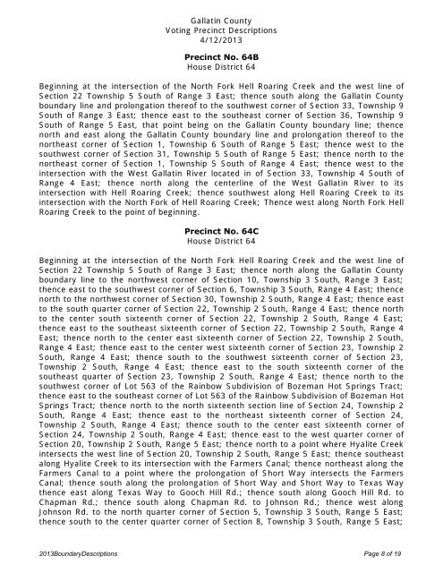
<strong>Gallatin</strong> <strong>County</strong><br />
Voting Precinct <strong>Descriptions</strong><br />
4/12/<strong>2013</strong><br />
Precinct No. 64B<br />
House District 64<br />
Beginning at the intersection of the North Fork Hell Roaring Creek and the west line of<br />
Section 22 Township 5 South of Range 3 East; thence south along the <strong>Gallatin</strong> <strong>County</strong><br />
boundary line and prolongation thereof to the southwest corner of Section 33, Township 9<br />
South of Range 3 East; thence east to the southeast corner of Section 36, Township 9<br />
South of Range 5 East, that point being on the <strong>Gallatin</strong> <strong>County</strong> boundary line; thence<br />
north and east along the <strong>Gallatin</strong> <strong>County</strong> boundary line and prolongation thereof to the<br />
northeast corner of Section 1, Township 6 South of Range 5 East; thence west to the<br />
southwest corner of Section 31, Township 5 South of Range 5 East; thence north to the<br />
northeast corner of Section 1, Township 5 South of Range 4 East; thence west to the<br />
intersection with the West <strong>Gallatin</strong> River located in of Section 33, Township 4 South of<br />
Range 4 East; thence north along the centerline of the West <strong>Gallatin</strong> River to its<br />
intersection with Hell Roaring Creek; thence southwest along Hell Roaring Creek to its<br />
intersection with the North Fork of Hell Roaring Creek; Thence west along North Fork Hell<br />
Roaring Creek to the point of beginning.<br />
Precinct No. 64C<br />
House District 64<br />
Beginning at the intersection of the North Fork Hell Roaring Creek and the west line of<br />
Section 22 Township 5 South of Range 3 East; thence north along the <strong>Gallatin</strong> <strong>County</strong><br />
boundary line to the northwest corner of Section 10, Township 3 South, Range 3 East;<br />
thence east to the southwest corner of Section 6, Township 3 South, Range 4 East; thence<br />
north to the northwest corner of Section 30, Township 2 South, Range 4 East; thence east<br />
to the south quarter corner of Section 22, Township 2 South, Range 4 East; thence north<br />
to the center south sixteenth corner of Section 22, Township 2 South, Range 4 East;<br />
thence east to the southeast sixteenth corner of Section 22, Township 2 South, Range 4<br />
East; thence north to the center east sixteenth corner of Section 22, Township 2 South,<br />
Range 4 East; thence east to the center west sixteenth corner of Section 23, Township 2<br />
South, Range 4 East; thence south to the southwest sixteenth corner of Section 23,<br />
Township 2 South, Range 4 East; thence east to the south sixteenth corner of the<br />
southeast quarter of Section 23, Township 2 South, Range 4 East; thence north to the<br />
southwest corner of Lot 563 of the Rainbow Subdivision of Bozeman Hot Springs Tract;<br />
thence east to the southeast corner of Lot 563 of the Rainbow Subdivision of Bozeman Hot<br />
Springs Tract; thence north to the north sixteenth section line of Section 24, Township 2<br />
South, Range 4 East; thence east to the northeast sixteenth corner of Section 24,<br />
Township 2 South, Range 4 East; thence south to the center east sixteenth corner of<br />
Section 24, Township 2 South, Range 4 East; thence east to the west quarter corner of<br />
Section 20, Township 2 South, Range 5 East; thence north to a point where Hyalite Creek<br />
intersects the west line of Section 20, Township 2 South, Range 5 East; thence southeast<br />
along Hyalite Creek to its intersection with the Farmers Canal; thence northeast along the<br />
Farmers Canal to a point where the prolongation of Short Way intersects the Farmers<br />
Canal; thence south along the prolongation of Short Way and Short Way to Texas Way<br />
thence east along Texas Way to Gooch Hill Rd.; thence south along Gooch Hill Rd. to<br />
Chapman Rd.; thence south along Chapman Rd. to Johnson Rd.; thence west along<br />
Johnson Rd. to the north quarter corner of Section 5, Township 3 South, Range 5 East;<br />
thence south to the center quarter corner of Section 8, Township 3 South, Range 5 East;<br />
<strong>2013</strong><strong>Boundary</strong><strong>Descriptions</strong> Page 8 of 19


