

Desktop Environmental, Hydrological and Geotechnical Study
Desktop Environmental, Hydrological and Geotechnical Study
Desktop Environmental, Hydrological and Geotechnical Study

Create successful ePaper yourself
Turn your PDF publications into a flip-book with our unique Google optimized e-Paper software.
Precinct Structure Plan Area 25<br />
Growth Areas Authority<br />
<strong>Desktop</strong> <strong>Environmental</strong>, <strong>Hydrological</strong><br />
<strong>and</strong> <strong>Geotechnical</strong> <strong>Study</strong><br />
Reference: 230243-001<br />
Prepared for: Growth<br />
Areas Authority<br />
Revision: 2<br />
13 September 2012
Contents<br />
Glossary of terms 1<br />
Executive summary 1<br />
1. Introduction <strong>and</strong> objectives 1<br />
1.1 Background 1<br />
1.2 Objectives 1<br />
1.3 Scope of work 1<br />
1.3.1 <strong>Desktop</strong> review 1<br />
1.3.2 Site inspection 2<br />
1.3.3 Reporting 2<br />
1.4 Legislative requirements <strong>and</strong> relevant assessment guidelines 2<br />
1.5 Limitations 3<br />
2. Site identification 4<br />
2.1 Location <strong>and</strong> description 4<br />
2.2 Site features 7<br />
2.3 Surrounding l<strong>and</strong> use 7<br />
2.4 Proposed l<strong>and</strong> use 7<br />
2.5 Topography 7<br />
2.6 Geology 7<br />
2.7 Soil characteristics 7<br />
2.8 Acid sulphate soils 8<br />
2.9 Historical mining activity 8<br />
2.10 Inferred geological conditions 8<br />
2.11 Identified l<strong>and</strong>forms <strong>and</strong> geomorphological features 9<br />
2.12 Identified geotechnical hazards 9<br />
2.13 Hydrology <strong>and</strong> hydrogeology 10<br />
2.13.1 General site assessment 10<br />
2.13.2 Surface water assessment 10<br />
2.13.3 Groundwater assessment 11<br />
2.13.4 Groundwater resources <strong>and</strong> usage 12<br />
2.14 Review of Wetl<strong>and</strong>s databases <strong>and</strong> sites of National <strong>Environmental</strong> Significance 13<br />
2.14.1 General 13<br />
2.14.2 Directory of Important Wetl<strong>and</strong>s in Australia 13<br />
2.14.3 DSE Biodiversity Interactive Map 13<br />
3. Records review 14<br />
3.1 Search of public records 14<br />
Project 230243-001-01 | File 20120912 PSP25 <strong>Desktop</strong> 230243.docx | 13 September 2012 | Revision 2<br />
p 1
3.1.1 Certificates of title 14<br />
3.1.2 <strong>Environmental</strong> Protection Authority 14<br />
3.1.3 Local government records 15<br />
3.1.4 Other government records 15<br />
3.1.5 Aerial photographs 15<br />
3.1.6 Australian heritage databases 18<br />
3.1.7 Previous reports <strong>and</strong> documents 19<br />
3.2 Summary of historic contamination potential 19<br />
4. Site inspection 21<br />
4.1 General 21<br />
4.2 Significant issues 21<br />
4.3 Areas of environmental concern 21<br />
5. <strong>Environmental</strong> risk 23<br />
5.1 General 23<br />
5.2 Site characterisation - conceptual site model 23<br />
5.2.1 General 23<br />
5.2.2 Contaminants of concern 23<br />
5.2.3 Exposure pathways 24<br />
5.2.4 Potential receptors 24<br />
5.2.5 <strong>Environmental</strong> considerations 25<br />
5.3 Qualitative risk assessment 25<br />
5.4 Risk assessment summary 27<br />
6. Summary 38<br />
6.1 Site contamination 38<br />
6.2 <strong>Geotechnical</strong> 38<br />
6.3 Hydrology 39<br />
6.4 Wetl<strong>and</strong>s 39<br />
6.5 Heritage sites 40<br />
7. Recommendations 41<br />
7.1 Contamination 41<br />
7.2 <strong>Geotechnical</strong> 42<br />
7.3 Hydrology <strong>and</strong> wetl<strong>and</strong>s 42<br />
8. References 48<br />
Project 230243-001-01| File 20120912 PSP25 <strong>Desktop</strong> 230243.docx | 13 September 2012 | Revision 2<br />
p 2
Index of Tables<br />
Table 1 Site property details .................................................................................................................... 4<br />
Table 2 Summary of key geotechnical constraints .................................................................................. 9<br />
Table 3 Registered groundwater bores in vicinity of the site ................................................................. 12<br />
Table 4 Crown allotment l<strong>and</strong> ................................................................................................................ 14<br />
Table 5 Significant site title information ................................................................................................. 14<br />
Table 6 Aerial photographs reviewed .................................................................................................... 15<br />
Table 7 Aerial photograph review summary .......................................................................................... 16<br />
Table 8 Heritage site summary ............................................................................................................. 19<br />
Table 9 Summary of site AECs ............................................................................................................. 21<br />
Table 10 Potential receptors <strong>and</strong> pathways .......................................................................................... 24<br />
Table 11 <strong>Environmental</strong> considerations ................................................................................................ 25<br />
Table 12 Derivation of risk classes ........................................................................................................ 25<br />
Table 13 Risk classifications ................................................................................................................. 26<br />
Table 14 Overall risk matrix ................................................................................................................... 26<br />
Table 15 Qualitative risk assessment, PSP Area 25 ............................................................................. 28<br />
Table 16 Assessment recommendations by property, PSP Area 25 .................................................... 43<br />
Appendices<br />
Appendix A<br />
Figures<br />
Appendix B<br />
Certificates of titles<br />
Appendix C<br />
Regulatory records documentation<br />
Appendix D<br />
Aerial photography<br />
Appendix E<br />
Site photographs<br />
Appendix F<br />
<strong>Geotechnical</strong> category of investigation<br />
Project 230243-001-01| File 20120912 PSP25 <strong>Desktop</strong> 230243.docx | 13 September 2012 | Revision 2<br />
p 3
Glossary of terms<br />
AEC Area of <strong>Environmental</strong> Concern<br />
ANZECC Australian <strong>and</strong> New Zeal<strong>and</strong> Environment <strong>and</strong> Conservation Council<br />
bgl Below Ground Level<br />
BTEX Benzene, Toluene, Ethylbenzene, <strong>and</strong> Xylenes<br />
DSE Department of Sustainability <strong>and</strong> Environment<br />
EPA Environment Protection Authority<br />
GAA Growth Areas Authority<br />
GIS Geographic Information System<br />
Ha hectares<br />
IWRG Industrial Waste Resource Guidelines<br />
km kilometres<br />
MSL Mean Sea Level<br />
NEPM National Environment Protection Measure<br />
NHMRC National Health <strong>and</strong> Medical Research Council<br />
PAH Polycyclic Aromatic Hydrocarbons<br />
PSP Precinct Structure Plan<br />
SEPP State <strong>Environmental</strong> Planning Policy<br />
TPH Total Petroleum Hydrocarbons<br />
UFZ Urban Floodway Zone<br />
Project 230243-001-01 | File 20120912 PSP25 <strong>Desktop</strong> 230243.docx | 13 September 2012 | Revision 2<br />
p 1
Executive summary<br />
Background<br />
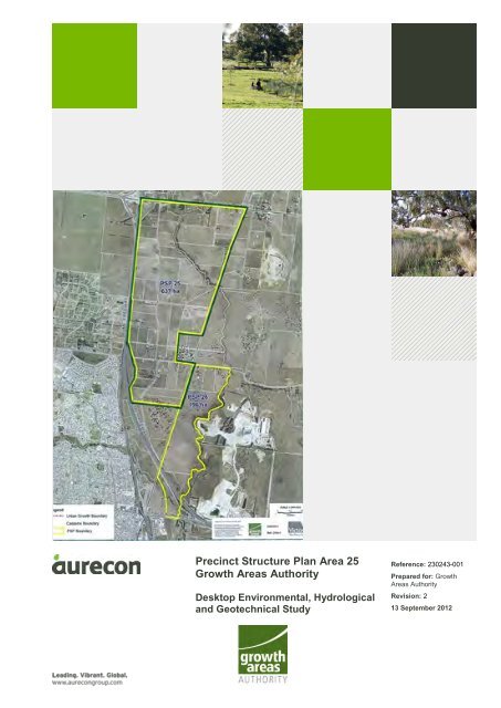
The Growth Areas Authority (GAA) is preparing a Precinct Structure Plan (PSP) for Area 25,<br />
comprised of approximately 637 hectares (ha) of l<strong>and</strong> on 54 separate properties located east of the<br />
Hume Freeway near Craigieburn, Kalkallo <strong>and</strong> Donnybrook, in the Hume City <strong>and</strong> City of Whittlesea<br />
local government areas, Victoria, Australia. Limited information regarding future l<strong>and</strong> uses within PSP<br />
Area 25 was provided by GAA for the purposes of this assessment. This assessment will inform the<br />
design of the urban structure of PSP 25 in terms of suitability of nominated l<strong>and</strong> uses. Historical<br />
research, document review <strong>and</strong> site assessment activities were conducted during the weeks of 29<br />
June <strong>and</strong> 20 July 2012.<br />
Scope of work<br />
The scope of works called for:<br />
• A desktop review to determine previous l<strong>and</strong> uses <strong>and</strong> implications for environmental<br />
contamination, hydrology <strong>and</strong> geology.<br />
• A desktop review of soil, geological <strong>and</strong> hydrogeological conditions on the site.<br />
• Review of Wetl<strong>and</strong>s databases <strong>and</strong> sites of National <strong>Environmental</strong> Significance.<br />
• Performance of a site inspection limited to publicly accessible areas of the site.<br />
Site contamination<br />
In general, the following past or present site activities, with the potential to cause soil or groundwater<br />
contamination, were identified in proximity to the PSP 25 Area:<br />
• An apparent out of production market garden on parcel 502095 (810 Summerhill Road).<br />
• Farm equipment <strong>and</strong> ab<strong>and</strong>oned automobiles stored on a number of site properties (eg 780<br />
Donnybrook Road, 295 Brookville Drive <strong>and</strong> 220 Brookville Drive).<br />
• Large scale intensive farming operations where fertilisers, pesticides, <strong>and</strong> herbicides may have<br />
been used (eg 30 Amaroo Road, 185 <strong>and</strong> 295 Brookville Drive).<br />
• Small scale intensive farming operations where fertilisers, pesticides, <strong>and</strong> herbicides may have<br />
been used (eg 800 Donnybrook Road, 245 <strong>and</strong> 275 Brookville Drive, 770, 790, 835 <strong>and</strong> 840<br />
Summerhill Road).<br />
• Areas where ab<strong>and</strong>oned vehicles, farm equipment, debris or dumping of unspecified materials<br />
have occurred (eg 720 Donnybrook Road, 30 Amaroo Road, 220 <strong>and</strong> 295 Brookville Drive,<br />
920/920A Hume Highway <strong>and</strong> 60 Kinloch Court).<br />
• Structures that may contain asbestos <strong>and</strong> have lead based paint <strong>and</strong> septic systems.<br />
• A large truck stop service station, constructed between 2006 <strong>and</strong> 2010, is located on the<br />
southwest corner of the interchange of Hume Freeway <strong>and</strong> Donnybrook Road.<br />
• Potential transport of contamination from off-site sources hydraulically upgradient of the Area<br />
onto the site via Merri Creek or Kalkallo Creek.<br />
Project 230243-001-01 | File 20120912 PSP25 <strong>Desktop</strong> 230243.docx | 13 September 2012 | Revision 2<br />
p 1
Recommendations for assessment of individual site properties based on use <strong>and</strong> potential for<br />
contamination are summarized in the report. Recommendations are made in accordance with the<br />
Victoria DSE Potentially Contaminated L<strong>and</strong>, General Practice Note, 2005 (DSE, 2005). Where l<strong>and</strong><br />
has been identified as potentially contaminated, a further investigation is necessary as part of the next<br />
stage of the planning process such as planning permit application or planning scheme amendment on<br />
a property by property basis (DSE, 2005).<br />
Of the fifty-four (54) site properties, further assessment is recommended for twenty-two (22)<br />
properties, with recommendations for environmental audits on four additional properties. In general,<br />
recommendations for assessment were made based on sensitive l<strong>and</strong> use, such as large-scale<br />
intensive agriculture. The presence of significant (more than 0.5 ha) small-scale agriculture,<br />
ab<strong>and</strong>oned vehicles, farm equipment or unidentified debris was considered secondary indicators of<br />
the need for assessment in the case of sensitive l<strong>and</strong> use. <strong>Environmental</strong> audits were recommended<br />
for the former market garden at 810 Summerhill Road <strong>and</strong> properties used for large-scale intensive<br />
agriculture at 30 Amaroo Road, 185 Brookville Drive <strong>and</strong> 295 Brookville Drive, each of which was<br />
considered at high potential for contamination based on past <strong>and</strong> present l<strong>and</strong> use. Due to the limited<br />
nature of the site inspection, additional site properties may be recommended for assessment in the<br />
future based on receipt of additional information not available at the time of this assessment.<br />
Intrusive sampling <strong>and</strong> analysis should be undertaken in accordance with National Environment<br />
Protection (Assessment of Site Contamination) Measure (1999 NEPM) <strong>and</strong> draft 2011 NEPM,<br />
Australian St<strong>and</strong>ard (2005) Guide to the investigation <strong>and</strong> sampling of sites with potentially<br />
contaminated soil Part 1: Non-volatile <strong>and</strong> semi-volatile compounds (AS 4482.1-2005), Australian<br />
St<strong>and</strong>ard (1999) Guide to the sampling <strong>and</strong> investigation of potentially contaminated soil Part 2:<br />
Volatile substances (AS 4482.2-1999) <strong>and</strong> Victoria Environment Protection Authority, Industrial Waste<br />
Resource Guidelines (IWRG) Soil Sampling, 2009. The results of the sampling <strong>and</strong> analysis would be<br />
compared with guideline values for protection of human health <strong>and</strong> the environment as well as waste<br />
disposal criteria (as applicable).<br />
In addition, hazardous materials surveys should be carried out for structures identified for demolition<br />
or relocation. The surveys should address asbestos, lead-based paint, polychlorinated biphenyls in<br />
electrical fixtures, <strong>and</strong> hazardous materials storage. Should asbestos containing material be<br />
encountered during future investigations or construction, the testing, inspection <strong>and</strong> removal of<br />
asbestos materials are required by law to be undertaken by a suitably qualified <strong>and</strong> licensed asbestos<br />
specialist/removalist.<br />
<strong>Geotechnical</strong><br />
Limited geotechnical data are available for the site. The geology of PSP Area 25 is predominantly<br />
Pleistocene <strong>and</strong> Miocene basalts with minor scoria <strong>and</strong> ash belonging to the Newer Volcanic Group,<br />
overlain by Holocene quaternary alluvial deposits of gravel, s<strong>and</strong> <strong>and</strong> silt concentrated along existing<br />
creek courses. The site is predominantly overlain by sodosol-type soils which are found to vary in<br />
texture <strong>and</strong> depth though generally comprises clay <strong>and</strong> s<strong>and</strong> loam. Sodosols have a high clay content<br />
<strong>and</strong> high sodium which sometimes leads to dispersion <strong>and</strong> instability. Localised fill or natural reworked<br />
material deposits are likely to be present on site, especially around areas of recent development,<br />
however further investigation will be required to identify <strong>and</strong> delineate these occurrences.<br />
In general, PSP Area 25 is gently undulating <strong>and</strong> soil cover is expected to be relatively thin. As such<br />
the risk of geotechnical hazards are considered low to moderate though a thorough underst<strong>and</strong>ing of<br />
the geological model will be required prior to development. The key geotechnical constraints that may<br />
affect the development of PSP Area 25 are:<br />
Project 230243-001-01| File 20120912 PSP25 <strong>Desktop</strong> 230243.docx | 13 September 2012 | Revision 2<br />
p 2
• Differential settlement of overlying residual clay in localised areas of extremely weathered basalt.<br />
Alluvial clay <strong>and</strong> silt deposits <strong>and</strong> localised un-engineered fill material may result in settlement of<br />
proposed road formations <strong>and</strong> structures. The alluvial sediments tend to be concentrated along<br />
existing creek courses, such as Merri Creek <strong>and</strong> Kalkallo Creek on PSP Area 25.<br />
• Shallow soil failure (soil creep, slumping, collapse) in areas of increased gradient. Although PSP<br />
Area 25 is of a relatively gentle gradient, steeper slopes are noted in close proximity to surface<br />
water bodies such as Merri Creek. Weathered alluvial or residual material can be susceptible to<br />
shallow soil failure (soil creep, slumping <strong>and</strong> collapse) in areas of increased gradient.<br />
• The presence of voids in scoria could result in the loss of stability or localised collapse hazard.<br />
• Low bearing capacity within soft clay material or unconsolidated alluvial material can result in a<br />
loss of stability or potential collapse of structures during the construction phase of the<br />
development. The presence of soft material encountered at depth may result in a bearing<br />
capacity or settlement hazard for any proposed foundations.<br />
• Clay likely to be derived from basalt rock is likely to be subject to considerable shrinkage or<br />
swelling in response to change in moisture content. Highly expansive clay can cause unexpected<br />
ground movements that are able to damage to building foundations, structures <strong>and</strong> road<br />
infrastructure. The published soils map indicates that the Area is predominantly overlain by<br />
sodosol-type soils which are found to vary in texture <strong>and</strong> depth though generally comprise clay<br />
<strong>and</strong> s<strong>and</strong> loam. Sodosols have a high clay content <strong>and</strong> high sodium which sometimes leads to<br />
dispersion <strong>and</strong> instability.<br />
• Ephemeral creeks, primarily draining into Merri Creek, could serve as drainage channels during<br />
flood events, resulting in erosion of soft sediment <strong>and</strong> bedrock. Similar conditions could develop<br />
within the main channels of Merri Creek <strong>and</strong> Kalkallo Creek on PSP Area 25.<br />
• The presence of zones of deeper residual soils or swamp conditions may affect footing design <strong>and</strong><br />
performance.<br />
It is recommended that further geotechnical assessment be undertaken across the site to aid the<br />
detailed design process for future construction in the PSP area on a project by project basis (ie road<br />
works <strong>and</strong> services on a PSP level or at the property development level for residences etc.). The<br />
purpose of the geotechnical assessment will be to undertake intrusive investigation to obtain<br />
information for the purposes of:<br />
• Determining a better underst<strong>and</strong>ing of the sub-surface geological profile <strong>and</strong> hydrogeological<br />
conditions to develop an accurate geological model.<br />
• Develop baseline geotechnical parameters to aid design, settlement <strong>and</strong> slope stability modelling<br />
(where required).<br />
• Determine depth to rock head <strong>and</strong> degree of weathering within the upper layers of the bedrock.<br />
• Determine the nature of factures <strong>and</strong> jointing within the underlying volcanic material.<br />
• Determine the presence of voids within the underlying basalt material.<br />
Hydrology <strong>and</strong> wetl<strong>and</strong>s<br />
Two semi-ephemeral creeks, Merri Creek <strong>and</strong> Kalkallo Creek. are located on the northern half of the<br />
site. An unnamed semi-ephemeral creek is located in the northwest corner of the property <strong>and</strong> drains<br />
into Kalkallo Creek. Occasional small ponds are located along each of these creeks. The site is within<br />
the 396 square kilometres (km 2 ) Merri Creek catchment, a major tributary of the Yarra River Basin.<br />
The creeks are fed from catchments in the north, flowing to the south where the Merri Creek<br />
eventually joins the Yarra River. No water level data for Merri Creek was available from Melbourne<br />
Water.<br />
Project 230243-001-01| File 20120912 PSP25 <strong>Desktop</strong> 230243.docx | 13 September 2012 | Revision 2<br />
p 3
There is an Urban Floodway Zone (UFZ) at a minimum of 100 m either side of Merri Creek <strong>and</strong><br />
Kalkallo Creek. This area has been identified as having a greater risk of flooding. A permit is required<br />
to carry out works in this area <strong>and</strong> must be consistent with the local Floodplain Development Plan.<br />
No groundwater level information was available for the boreholes located on the site. The closest<br />
borehole to the site for which groundwater level data was available was borehole B68888, located<br />
approximately 665 m south of site southern boundary, at 95-135 Amaroo Road. This borehole showed<br />
a groundwater depth on 1 April 2009 of 15.71 m below ground level (bgl). Aerial photographs show<br />
exposed groundwater in numerous irrigation ponds on the Area. Although depth to groundwater is<br />
difficult to assess in the aerial photographs, this is believed to be indicative of a depth to groundwater<br />
of less than 5 m on the site. This ground water is not believed to represent a perched water table.<br />
Groundwater beneath the site is present in two main aquifers, the upper Newer Volcanics aquifer, a<br />
fractured rock basalt aquifer, <strong>and</strong> a deeper regional aquifer within the Silurian aged formation. The<br />
Victorian Water Resources Data Warehouse <strong>and</strong> GeoVic GIS tools identified 30 registered boreholes<br />
within 1 km of the site. Borehole usage was primarily domestic <strong>and</strong> agricultural water supply with a<br />
small number of extractive industries boreholes.<br />
No nationally important wetl<strong>and</strong>s, wetl<strong>and</strong> sites of National <strong>Environmental</strong> Significance or sites of state<br />
significance were identified within the PSP area.<br />
The following recommendations are made regarding hydrology <strong>and</strong> wetl<strong>and</strong>s:<br />
• UFZs should remain free of any significant development as they are at risk of flooding.<br />
• Flood modelling should be undertaken to determine hydrologic effects that any new developments<br />
will have on the existing creek system, in particular existing culvert <strong>and</strong> bridge flow capacities.<br />
• Waterways, including Merri Creek <strong>and</strong> Kalkallo Creek <strong>and</strong> associated low-lying areas will require<br />
feature surveys to provide detail of drainage patterns <strong>and</strong> inform planning for urban drainage<br />
systems.<br />
• Drainage paths will need to be either maintained or diverted to ensure all areas are well drained<br />
during <strong>and</strong> after any development.<br />
Project 230243-001-01| File 20120912 PSP25 <strong>Desktop</strong> 230243.docx | 13 September 2012 | Revision 2<br />
p 4
1. Introduction <strong>and</strong> objectives<br />
1.1 Background<br />
The Growth Areas Authority (GAA) is preparing a Precinct Structure Plan (PSP) for Area 25,<br />
comprised of approximately 637 hectares (ha) of l<strong>and</strong> on 54 separate properties located east of the<br />
Hume Freeway near Craigieburn, Kalkallo <strong>and</strong> Donnybrook, in the Hume City <strong>and</strong> City of Whittlesea<br />
local government areas, Victoria, Australia. This assessment will inform the design of the urban<br />
structure of PSP 25 in terms of suitability of nominated l<strong>and</strong> uses. Historical research, document<br />
review <strong>and</strong> site assessment activities were conducted during the weeks of 29 June <strong>and</strong> 20 July 2012.<br />
1.2 Objectives<br />
The overall objective of this desktop environmental, hydrological <strong>and</strong> geotechnical study is to identify<br />
the potential for ground contamination within the study area <strong>and</strong> the nature of likely contaminants to be<br />
encountered during detailed design <strong>and</strong> construction.<br />
The key objectives of this assessment were to conduct a desktop study <strong>and</strong> site inspection to:<br />
• Confirm suitability of properties for sensitive uses <strong>and</strong> provide advice regarding what level of<br />
further assessment would be required to determine suitability of properties for sensitive uses in<br />
accordance with the Potentially Contaminated L<strong>and</strong> General Practice Note 2005 (eg.<br />
<strong>Environmental</strong> Audit, Site Assessment).<br />
• Identify data gaps <strong>and</strong> outline future testing requirements <strong>and</strong> the need for more detailed<br />
investigations (if required).<br />
• Provide a plan of the study area clearly showing which properties were included in the desktop<br />
study <strong>and</strong> which properties have low, medium <strong>and</strong> high risk of contamination.<br />
• Prepare a report of findings that will be used to inform the design of precinct structure plans for<br />
the study area (in terms of suitability of l<strong>and</strong> uses nominated for each location/area) <strong>and</strong> to<br />
identify key issues that should be addressed during the detailed design phase <strong>and</strong> construction.<br />
1.3 Scope of work<br />
1.3.1 <strong>Desktop</strong> review<br />
A desktop review was conducted to evaluate current <strong>and</strong> previous l<strong>and</strong> uses <strong>and</strong> to assess the<br />
implications for environmental contamination, hydrology <strong>and</strong> geology. The desktop review included:<br />
• Assessment of historical aerial photography for the precinct <strong>and</strong> surrounding areas.<br />
• Consultation with relevant agencies as required, including:<br />
o EPA for review of records including the ‘Priority Sites Registry’ (EPA Victoria, 2012a) <strong>and</strong> the<br />
list of issued ‘Certificates <strong>and</strong> Statements of <strong>Environmental</strong> Audit’ (EPA Victoria 2012b).<br />
o Department of Sustainability <strong>and</strong> Environment, Port Phillip & Westernport Catchment<br />
Management Authority, Southern Rural water, City West Water <strong>and</strong> Melbourne Water for<br />
hydrographs, groundwater <strong>and</strong> drainage information <strong>and</strong> other relevant data.<br />
• Soil, geology <strong>and</strong> hydrogeology conditions desktop review, including survey, mapping <strong>and</strong> other<br />
base data as available from relevant authority <strong>and</strong> agency data sets <strong>and</strong> maps. This is aimed at<br />
identifying potential shortcomings in data coverage.<br />
• Review <strong>and</strong> summary of any previous reports or studies regarding environmental, geological or<br />
groundwater conditions, in or within the vicinity of the study area.<br />
Project 230243-001-01 | File 20120912 PSP25 <strong>Desktop</strong> 230243.docx | 13 September 2012 | Revision 2<br />
p 1
• Compilation of known groundwater borehole/well locations <strong>and</strong> testing results.<br />
• Groundwater well databases.<br />
• Review of Wetl<strong>and</strong>s databases <strong>and</strong> sites of National <strong>Environmental</strong> Significance.<br />
• Review of Australian Heritage Databases.<br />
• Obtainment <strong>and</strong> analysis of current titles for all properties in the study area.<br />
• Historical title search of any properties where further historical l<strong>and</strong> use information is needed to<br />
establish potential for contamination.<br />
• Review of Victoria Department of Primary Industries online GIS system, GeoVic.<br />
1.3.2 Site inspection<br />
Aurecon performed a site inspection of the study area, evaluating properties from existing roadways<br />
<strong>and</strong> publicly accessible areas. At the Client’s request, no on-site inspection of properties within PSP<br />
Area 25 was performed. The site inspection was conducted once the desktop review had been<br />
completed <strong>and</strong> was used to focus on-site observations.<br />
1.3.3 Reporting<br />
Based on the findings of this desktop assessment, Aurecon prepared this report including the<br />
following:<br />
• Summary of findings <strong>and</strong> recommendations of the desktop review <strong>and</strong> site inspection for each<br />
discipline area (environmental, hydrology <strong>and</strong> geotechnical assessment).<br />
• Issues summary <strong>and</strong> resultant recommendations for management <strong>and</strong>/or remediation in terms of<br />
environmental contamination, geology/geotechnical <strong>and</strong> hydrology/groundwater.<br />
• Outline of any future testing requirements <strong>and</strong> the need for more detailed investigations if<br />
recommended.<br />
• Evaluation (to the extent practicable within limitations) of the suitability of properties for sensitive<br />
uses <strong>and</strong> what level of further assessment would be required to determine suitability of properties<br />
for sensitive uses in accordance with the Potentially Contaminated L<strong>and</strong> General Practice Note<br />
2005 (eg <strong>Environmental</strong> Audit, Site Assessment).<br />
• A plan of the study area clearly showing which properties were included in the desktop study <strong>and</strong><br />
which properties have low, medium <strong>and</strong> high potential for contamination.<br />
• Clear <strong>and</strong> concise drawings/maps, to illustrate existing conditions <strong>and</strong> support report as required.<br />
It should be noted that this report is a limited desktop assessment of the site <strong>and</strong> no sampling was<br />
performed for this assessment.<br />
1.4 Legislative requirements <strong>and</strong> relevant assessment guidelines<br />
The scope of work for this desktop environmental, hydrological <strong>and</strong> geotechnical assessment of the<br />
site has been performed in general accordance with requirements outlined in the following documents:<br />
• Victoria <strong>Environmental</strong> Protection Act 1970<br />
• State Environment Protection Policy (SEPP), Groundwaters of Victoria, December 1997,<br />
No. S160.<br />
• SEPP, Prevention <strong>and</strong> Management of Contaminated L<strong>and</strong>, June 2002, No. S95.<br />
• SEPP, Waters of Victoria, October 2004, No. S210.<br />
• EPA Victoria 2009a. Industrial Waste Resource Guidelines - Sampling <strong>and</strong> Analysis of Waters,<br />
Wastewaters, Soils <strong>and</strong> Wastes, June 2009, IWRG701.<br />
Project 230243-001-01 | File 20120912 PSP25 <strong>Desktop</strong> 230243.docx | 13 September 2012 | Revision 2<br />
p 2
• EPA Victoria 2009b, Industrial Waste Resource Guidelines - Soil Sampling, June 2009,<br />
IWRG702.<br />
• Australian <strong>and</strong> New Zeal<strong>and</strong> Guideline for the Assessment <strong>and</strong> Management of Contaminated<br />
Sites, published by Australian <strong>and</strong> New Zeal<strong>and</strong> Environment <strong>and</strong> Conservation Council<br />
(ANZECC) <strong>and</strong> the National Health <strong>and</strong> Medical Research Council (NHMRC), January 1992.<br />
• Guide to the investigation <strong>and</strong> sampling of sites with potentially contaminated soil, Part 1: Nonvolatile<br />
<strong>and</strong> semi-volatile compounds, AS 4482.1-2005, St<strong>and</strong>ards Australia.<br />
• Guide to the sampling <strong>and</strong> investigation of potentially contaminated soil, Part 2: Volatile<br />
substances, AS 4482.2-1999, St<strong>and</strong>ards Australia.<br />
• National Environment Protection (Assessment of Site Contamination) Measure, 1999.<br />
• National Environment Protection (Assessment of Site Contamination) Measure, draft 2011.<br />
• <strong>Environmental</strong> Protection Authority, A Guide to the Sampling <strong>and</strong> Analysis of Waters,<br />
Wastewaters, Soils <strong>and</strong> Wastes, March 2000, Publication 441.<br />
• Native Vegetation Management Framework 2002.<br />
• Wildlife Act 1975.<br />
1.5 Limitations<br />
Aurecon Australia Pty Ltd (ABN 54 005 139 873) has prepared this report (the "Report") for the<br />
exclusive use of GAA (the "Client"), regulatory authorities, auditors <strong>and</strong> others approved by the Client<br />
for the purpose of desktop environmental, hydrological, <strong>and</strong> geotechnical study for PSP Area 25.<br />
The Report must be read in light of:<br />
• The limited readership <strong>and</strong> purposes for which it was intended.<br />
• Its reliance upon information provided to Aurecon by the Client <strong>and</strong> others which has not been<br />
verified by Aurecon <strong>and</strong> over which Aurecon has no control.<br />
• The limitations <strong>and</strong> assumptions referred to throughout the Report.<br />
• The cost <strong>and</strong> other constraints imposed on the Report (such as limited site access).<br />
• Other relevant issues which are not within the scope of the Report.<br />
Subject to the limitations referred to above, Aurecon has exercised all due care in the preparation of<br />
the Report <strong>and</strong> believes that the information, conclusions, interpretations <strong>and</strong> recommendations of the<br />
Report are both reasonable <strong>and</strong> reliable.<br />
Aurecon makes no warranty or representation to the Client or third parties (express or implied) in<br />
respect of the Report, particularly with regard to any commercial investment decision made on the<br />
basis of the Report. Use of the Report by the Client or third parties shall be at their own risk <strong>and</strong><br />
extracts from the Report may only be published with permission of Aurecon.<br />
This disclaimer must accompany every copy of the Report, which is an integral document <strong>and</strong> must be<br />
read in its entirety.<br />
Project 230243-001-01 | File 20120912 PSP25 <strong>Desktop</strong> 230243.docx | 13 September 2012 | Revision 2<br />
p 3
2. Site identification<br />
2.1 Location <strong>and</strong> description<br />
The site is comprised of 54 separate properties totalling approximately 637 ha in area <strong>and</strong> designated<br />
as PSP Area 25 in the Craigieburn, Kalkallo <strong>and</strong> Donnybrook, in the Hume City <strong>and</strong> City of Whittlesea<br />
local government areas, Victoria, Australia. Site properties are summarized in<br />
Table 1.<br />
Table 1 Site property details<br />
No.<br />
Appendix B<br />
Page No.<br />
23341 1<br />
23358 10<br />
23366 17<br />
26997 25<br />
27003 30<br />
27011 35<br />
40<br />
27037 44<br />
66548 48<br />
397661 52<br />
411710 57<br />
501719 64<br />
501720 68<br />
501721 73<br />
501722 80<br />
501723 87<br />
501724 96<br />
Address Legal description<br />
780 Donnybrook Road<br />
CRAIGIEBURN VIC 3064<br />
800 Donnybrook Road<br />
CRAIGIEBURN VIC 3064<br />
804 Donnybrook Road<br />
CRAIGIEBURN VIC 3064<br />
45 English Street<br />
DONNYBROOK VIC 3064<br />
65 English Street<br />
DONNYBROOK VIC 3064<br />
90 English Street<br />
DONNYBROOK VIC 3064<br />
80 English Street<br />
DONNYBROOK VIC 3064<br />
80 English Street<br />
DONNYBROOK VIC 3064<br />
25 Norman Road<br />
DONNYBROOK VIC 3064<br />
750 Donnybrook Road<br />
CRAIGIEBURN VIC 3064<br />
810 Donnybrook Road<br />
CRAIGIEBURN VIC 3064<br />
25 Amaroo Road<br />
CRAIGIEBURN 3064<br />
65 Amaroo Road<br />
CRAIGIEBURN 3064<br />
85 Amaroo Road<br />
CRAIGIEBURN 3064<br />
30 Amaroo Road<br />
CRAIGIEBURN 3064<br />
50 Amaroo Road<br />
CRAIGIEBURN 3064<br />
105 Brookville Drive<br />
CRAIGIEBURN VIC 3064<br />
Project 230243-001-01 | File 20120912 PSP25 <strong>Desktop</strong> 230243.docx | 13 September 2012 | Revision 2<br />
p 4<br />
Title<br />
(Volume/Folio)<br />
Area<br />
(ha)<br />
Lot 1 LP 119619 9271/196 8.2<br />
Lot 2 LP 119619 9538/269 8.2<br />
Lot 1 TP 423925 8806/645 0.4<br />
Lot 3 LP 119619 9227/855 8.1<br />
Lot 4 LP 119619 9214/672 8.4<br />
CP 174104 10016/031 33.3<br />
Lot 1 TP 844886 10822/940<br />
Lot 1 TP 844886 10822/950 30.9<br />
CP 172167 RESERVE 9944/068 16.1<br />
Lot 1 TP 125838 9017/631 26.1<br />
CP 159200 9737/864 0.3<br />
Lot 4 LP 205880 9769/309 12.9<br />
Lot 7 LP 205880 9769/312 12.1<br />
Lot 8 LP 205880 9769/313 11.9<br />
Lot 2 PS 518232 9769/307 8.0<br />
Lot 3 PS 518232 9769/306 7.6<br />
Lot 1 PS 518231 9769/550 12.7
Table 1 Site property details<br />
No.<br />
Appendix B<br />
Page No.<br />
501725 105<br />
501726 112<br />
501727 120<br />
501728 128<br />
501729 137<br />
501730 144<br />
501731 150<br />
501732 160<br />
501733 170<br />
501734 177<br />
501735 186<br />
501779 192<br />
501781 197<br />
501782 212<br />
501783 236<br />
501784 239<br />
501785 273<br />
501955 283<br />
501956 283<br />
501904 291<br />
Address Legal description<br />
165 Brookville Drive<br />
CRAIGIEBURN VIC 3064<br />
185 Brookville Drive<br />
CRAIGIEBURN VIC 3064<br />
225 Brookville Drive<br />
CRAIGIEBURN VIC 3064<br />
245 Brookville Drive<br />
CRAIGIEBURN VIC 3064<br />
275 Brookville Drive<br />
CRAIGIEBURN VIC 3064<br />
295 Brookville Drive<br />
CRAIGIEBURN VIC 3064<br />
180 Brookville Drive<br />
CRAIGIEBURN VIC 3064<br />
220 Brookville Drive<br />
CRAIGIEBURN VIC 3064<br />
230 Brookville Drive<br />
CRAIGIEBURN VIC 3064<br />
270 Brookville Drive<br />
CRAIGIEBURN VIC 3064<br />
Project 230243-001-01 | File 20120912 PSP25 <strong>Desktop</strong> 230243.docx | 13 September 2012 | Revision 2<br />
p 5<br />
Title<br />
(Volume/Folio)<br />
Area<br />
(ha)<br />
Lot 10 LP 205835 9769/551 12.1<br />
Lot 6 LP 205834 9818/414 20.9<br />
Lot 5 LP 205834 9818/413 9.0<br />
Lot 24 PS 616391 9818/409 8.7<br />
Lot 23 PS 616391 9818/408 8.4<br />
Lot 22 PS 616391 9818/407 7.8<br />
Lot 7 LP 205834 9818/415 20.9<br />
Lot 8 LP 205834 9818/416 20.6<br />
Lot 9 LP 205833 9818/417 8.9<br />
Lot 10 LP 205833 9818/410 9.0<br />
184 Lot RD1 LP 205833 9818/412<br />
290 Brookville Drive<br />
CRAIGIEBURN VIC 3064<br />
315 Brookville Drive<br />
CRAIGIEBURN VIC 3064<br />
310 Brookville Drive<br />
CRAIGIEBURN VIC 3064<br />
670 Donnybrook Road<br />
CRAIGIEBURN VIC 3064<br />
700 Donnybrook Road<br />
CRAIGIEBURN VIC 3064<br />
714 Donnybrook Road<br />
CRAIGIEBURN VIC 3064<br />
720 Donnybrook Road<br />
CRAIGIEBURN VIC 3064<br />
920A Hume Highway<br />
CRAIGIEBURN 3064<br />
920 Hume Highway<br />
CRAIGIEBURN 3064<br />
980 Hume Highway<br />
CRAIGIEBURN 3064<br />
Lot 11 LP 205833 9818/411 9.1<br />
Lot 21 PS 616391 10111/889 3.7<br />
Lot 20 PS 616397 9693/576 9.6<br />
Lot 1 TP 324690<br />
RES1 PS 616393<br />
MUNICIPAL RESERVE<br />
RES2 LP 133012<br />
8553/206,<br />
11179/674,<br />
11046/035<br />
15.7<br />
Lot 1 LP 71220 10877/977 2.9<br />
Lot 1 LP 70557 8611/630 0.5<br />
Lot 1 TP 411428 8143/793 0.8<br />
Lot 2 PS 518231 9828/775 17.1<br />
Lot 2 PS 518231 9828/775 17.1<br />
Lot 1 TP 830130 9706/679 9.6
Table 1 Site property details<br />
No.<br />
Appendix B<br />
Page No.<br />
501953 303<br />
501984 310<br />
501985 316<br />
501986 323<br />
501987 329<br />
501988 336<br />
501989 343<br />
501990 371<br />
501991 379<br />
502087 387<br />
502088 391<br />
502089 394<br />
502093 399<br />
502094 406<br />
502095 412<br />
502096 419<br />
502097 428<br />
671180 440<br />
Address Legal description<br />
70 Amaroo Road<br />
CRAIGIEBURN 3064<br />
10 Kinloch Court<br />
CRAIGIEBURN 3064<br />
20 Kinloch Court<br />
CRAIGIEBURN 3064<br />
30 Kinloch Court<br />
CRAIGIEBURN 3064<br />
40 Kinloch Court<br />
CRAIGIEBURN 3064<br />
50 Kinloch Court<br />
CRAIGIEBURN 3064<br />
60 Kinloch Court<br />
CRAIGIEBURN 3064<br />
70 Kinloch Court<br />
CRAIGIEBURN 3064<br />
80 Kinloch Court<br />
CRAIGIEBURN 3064<br />
745 Summerhill Road<br />
CRAIGIEBURN 3064<br />
755 Summerhill Road<br />
CRAIGIEBURN 3064<br />
835 Summerhill Road<br />
CRAIGIEBURN 3064<br />
770 Summerhill Road<br />
CRAIGIEBURN 3064<br />
790 Summerhill Road<br />
CRAIGIEBURN 3064<br />
810 Summerhill Road<br />
CRAIGIEBURN 3064<br />
840 Summerhill Road<br />
CRAIGIEBURN 3064<br />
860 Summerhill Road<br />
CRAIGIEBURN 3064<br />
620 Donnybrook Road<br />
CRAIGIEBURN VIC 3064<br />
Project 230243-001-01 | File 20120912 PSP25 <strong>Desktop</strong> 230243.docx | 13 September 2012 | Revision 2<br />
p 6<br />
Title<br />
(Volume/Folio)<br />
Area<br />
(ha)<br />
Lot 4 PS 518232 9769/314 6.5<br />
Lot 11 LP 205835 9769/552 13.2<br />
Lot 12 LP 205835 9769/553 12.3<br />
Lot 13 LP 205835 9769/554 12.3<br />
Lot 14 LP 205835 9769/555 12.3<br />
Lot 15 LP 205835 9769/556 14.3<br />
Lot 16 LP 205835<br />
10191/894,<br />
9769/557<br />
13.5<br />
Lot 17 LP 205835 9769/558 12.8<br />
Lot 18 LP 205835 9769/559 14.3<br />
Lot 6 LP 205880 9769/311 12.1<br />
Lot 5 LP 205880 9769/310 12.0<br />
Lot 1 PS 518232 6769/308 8.9<br />
Lot 3 LP 143296 9546/805 12.3<br />
Lot 4 LP 143296 9546/806 12.4<br />
Lot 5 LP 143296 9546/807 12.3<br />
Lot 6 LP 143296 9546/808 12.4<br />
Lot 3 PS 518231T 9546/809 9.1<br />
RES1 PS 616391<br />
ROADS<br />
CORPORATION<br />
RESERVE<br />
445 Lot RD1 LP 205880 9769/315<br />
447 Lot RD1 LP 205835 9769/560<br />
447 Lot RD2 LP 205835 9769/560<br />
449 Lot RD1 LP 143296 9546/811<br />
11144/826 9.2
2.2 Site features<br />
The properties that comprise the site are generally rural residential properties with small-scale<br />
agriculture, agricultural properties with relatively intensive cultivation or undeveloped property. An<br />
electricity transmission line crosses the site from east to west, approximately 1.5 km south of the<br />
northern Area boundary. The site is bounded to the south by undeveloped l<strong>and</strong>; to the west by the<br />
Hume Freeway, to the north by Donnybrook Road, <strong>and</strong> to the east by the North Eastern Railway line<br />
<strong>and</strong> agricultural l<strong>and</strong>. Site location <strong>and</strong> features are presented on Figure 1 in Appendix A.<br />
2.3 Surrounding l<strong>and</strong> use<br />
The surrounding area is characterized by generally rolling plains used primarily for residential<br />
properties <strong>and</strong> non-intensive agricultural purposes such as livestock grazing <strong>and</strong> livestock feed<br />
production. The l<strong>and</strong> uses directly adjacent to the site are as follows:<br />
• West – Hume Freeway, across which lies dry non-intensive agricultural l<strong>and</strong> with farm<br />
residences, rural residential properties <strong>and</strong> a truck stop service station.<br />
• North – Donnybrook Road, across which lies non-intensive agricultural l<strong>and</strong>, rural residential<br />
properties <strong>and</strong> a railway station.<br />
• East – Dry non-intensive agricultural l<strong>and</strong> <strong>and</strong> the North Eastern Railway line, across which lies<br />
agricultural l<strong>and</strong> with farm residences.<br />
• South – Undeveloped l<strong>and</strong>.<br />
2.4 Proposed l<strong>and</strong> use<br />
This desktop study is part of the pre-planning process for PSP Area 25, with l<strong>and</strong> uses to be decided<br />
in the future. For purposes of the risk assessment, Aurecon has considered all potential l<strong>and</strong> use<br />
categories listed in the L<strong>and</strong> State <strong>Environmental</strong> Planning Policy (SEPP) <strong>and</strong> Groundwater SEPP.<br />
2.5 Topography<br />
The topography of the site slopes gently toward the southeast across the site from approximately<br />
226 m above mean sea level (MSL) in the northwest corner to approximately 208 m above MSL in the<br />
southeast corner. The majority of the site comprises undulating hills <strong>and</strong> ridges on volcanic plain with<br />
stony rises. The stream valleys of Merri Creek <strong>and</strong> Kalkallo Creek comprise the main elements of relief<br />
<strong>and</strong> terrain variation, with river valley cliffs <strong>and</strong> bluffs, <strong>and</strong> provide exposure of underlying geology.<br />
2.6 Geology<br />
The Melbourne sheet (SJ 55-5 Edition 2) in the 1:250,000 Geological Map Series 1997 (V<strong>and</strong>enberg,<br />
1997) indicates that the geology of PSP Area 25 is predominantly Pleistocene Quaternary to Miocene<br />
Neogene basalts of the Newer Volcanic Group with minor scoria <strong>and</strong> ash (tholeiitic to alkaline). The<br />
map indicates that the geology on the site also includes Holocene Quaternary fluvial alluvium, gravel,<br />
s<strong>and</strong> <strong>and</strong> silt confined to existing rivers <strong>and</strong> streams. The southwestern portion of PSP Area 25 is<br />
underlain by Pridoli to Ludlow Silurian age marine sedimentary deposits of the Dargile Formation,<br />
consisting of marine siltstone <strong>and</strong> thin-bedded s<strong>and</strong>stone. An area geology map is presented on<br />
Figure 2 in Appendix A.<br />
2.7 Soil characteristics<br />
The Digital Atlas of Australian Soils (NRIC 1991), based on Atlas of Australian Soils, Sheets 1 to 10<br />
(Northcote et al. 1960-68) identifies the soils beneath PSP Area 25 to be Sodosols [SO] classification.<br />
Project 230243-001-01 | File 20120912 PSP25 <strong>Desktop</strong> 230243.docx | 13 September 2012 | Revision 2<br />
p 7
Sodosols are a soil order of the Australian Soil Classification (Isbell, 2002) with an abrupt or clear<br />
change in texture at the B2 horizon. The B2 horizon in sodosols is sodic <strong>and</strong> not strongly acidic. These<br />
soils are often brightly coloured <strong>and</strong> have a pH of 5.5 (water) or greater in the upper B2 horizon.<br />
2.8 Acid sulphate soils<br />
The Digital Atlas of Australian Soils (NRIC 1991), based on Atlas of Australian Soils, Sheets 1 to 10<br />
(Northcote et al. 1960-68), indicates that PSP Area 25 has an extremely low probability of being at risk<br />
from Acid Sulphate Soils.<br />
2.9 Historical mining activity<br />
A review of the Victoria Dept. Primary Industries online geographic information system (GIS), GeoVic<br />
(DPI, 2012) indicates that PSP Area 25 has not been subjected to historical mining activity.<br />
2.10 Inferred geological conditions<br />
The published geological setting <strong>and</strong> existing information describes Holocene quaternary alluvial<br />
deposits overlying Pleistocene <strong>and</strong> Miocene basalts with minor scoria <strong>and</strong> ash belonging to the Newer<br />
Volcanic Group. The alluvial sediments tend to be concentrated along existing creek courses.<br />
The reported geological profile recorded by the existing borehole database confirms the published<br />
geological setting. Reported lithologies, from bore logs available in the Victorian Water Resources<br />
Data Warehouse, identify a layer of surficial fill or topsoil approximately 0.30 m to 0.50 m thick,<br />
overlying a layer of residual clay with a basalt bedrock surface generally ranging in depth between<br />
0.50 m <strong>and</strong> 3.0 m. The residual clay <strong>and</strong> extremely weathered rock (soil like) typically contain basalt<br />
cobbles <strong>and</strong> boulders. The transition between the soil/clay <strong>and</strong> rock is typically sharp.<br />
The south-western part of the site, as delineated in the geological plan (see Figure xx) is underlain by<br />
the Dargile Formation which comprises Silurian-age deep-water derived alternating beds of<br />
sedimentary mudstone <strong>and</strong> fine-grained s<strong>and</strong>stone. The Dargile Formation is typically folded into<br />
synclines or anticlines that dip at a gradient of between 45° <strong>and</strong> 70°. They are noted to be intruded<br />
locally by granite with accompanying tabular dykes.<br />
Basaltic lava is typically interbedded with minor scoria, lapilli <strong>and</strong> tuff deposits. Basaltic lava flows are<br />
typically very hard with polygonal vertical fractures near the upper <strong>and</strong> lower horizons. Vesicles are<br />
usually present in the upper surface. Fossil soil horizons can also develop on the surface of flows<br />
during a non-eruptive period, which have been buried by subsequent flows; Residual basaltic clay is<br />
typically of high plasticity <strong>and</strong> has reactive properties.<br />
Scoria deposits comprise typically angular to sub-angular, poorly sorted, gravel to boulder size basalt<br />
fragments that can form either welded rootless lava flows, or indistinct unwelded blocky deposits.<br />
Scoria <strong>and</strong> ash deposits typically weather to soft to very soft s<strong>and</strong>, silt <strong>and</strong> clay of medium to high<br />
plasticity. Tuff deposits typically comprised thin graded beds of unconsolidated basaltic s<strong>and</strong> <strong>and</strong> silt<br />
sized particles.<br />
Holocene alluvial deposits typically comprise undifferentiated interbedded poorly compacted gravel,<br />
s<strong>and</strong> <strong>and</strong> silt deposits. Cohesive material is typically very soft to firm, while granular material is<br />
typically very loose to loose, poorly consolidated angular to rounded basalt <strong>and</strong> s<strong>and</strong>stone derived<br />
from externally sourced bedrock.<br />
Colluvial deposits have also been documented along Merri Creek which comprise poorly to well sorted<br />
silt, s<strong>and</strong> <strong>and</strong> gravel.<br />
Project 230243-001-01 | File 20120912 PSP25 <strong>Desktop</strong> 230243.docx | 13 September 2012 | Revision 2<br />
p 8
The published soils map indicates the site is predominantly overlain by sodosol-type soils which are<br />
found to vary in texture <strong>and</strong> depth though generally comprise clay <strong>and</strong> s<strong>and</strong> loam. Sodosols have a<br />
high clay content <strong>and</strong> high sodium which sometimes leads to dispersion <strong>and</strong> instability.<br />
Localised fill or natural reworked material deposits are likely to be present on site, especially around<br />
areas of recent development, however further investigation will be required to identify <strong>and</strong> delineate<br />
these occurrences. In addition to the general subsurface profile, a review of aerial photography<br />
indicates some dry river or stream channels that may indicate the presence of localised pockets of<br />
soft, unconsolidated alluvial sediments that are not shown as being present on the geological map.<br />
Previous experience has shown that the basalt rock is generally permeable. The ground water table<br />
fluctuates seasonally due to rainfall <strong>and</strong> generally flows south towards Port Phillip Bay. A perched<br />
water table may be present within the soil layer at the interface between the residual clay/extremely<br />
weathered basalt <strong>and</strong> highly weathered basalt interface.<br />
2.11 Identified l<strong>and</strong>forms <strong>and</strong> geomorphological features<br />
The following l<strong>and</strong>forms have been identified within the study area:<br />
• Gently undulating hills <strong>and</strong> ridges<br />
• Undulating volcanic plain with stony rises<br />
• River valley cliffs <strong>and</strong> bluffs<br />
• Valley side slopes<br />
• Stream terraces, both bedrock <strong>and</strong> alluvial<br />
• Modern floodplain <strong>and</strong> stream channels<br />
These l<strong>and</strong> forms may have been significantly altered through anthropological l<strong>and</strong> use <strong>and</strong><br />
development in the previous 200 years, typically for flood protection though it is noted that regrading of<br />
slopes <strong>and</strong> replacement of natural soil may have occurred on site. A number of quarries are also<br />
noted in close proximity to the development area.<br />
2.12 Identified geotechnical hazards<br />
The identified geotechnical hazards considered to be appropriate for the site are summarised in<br />
Table 2.<br />
Table 2 Summary of key geotechnical constraints<br />
Constraints Discussion<br />
Settlement of<br />
proposed road<br />
formations <strong>and</strong><br />
structures<br />
Voids<br />
Slope stability<br />
Quaternary alluvial clay <strong>and</strong> silt deposits are typically poorly consolidated <strong>and</strong> un-lithified<br />
so may settle if unsupported or overloaded. The presence of localised un-engineered fill<br />
material may also result in a differential settlement hazard. Dependent on the state of<br />
weathering, localised areas of extremely weathered basalt may result in differential<br />
settlement of overlying residual clay.<br />
Where scoria is identified beneath the site, the presence of voids cannot be ruled out. The<br />
presence of unidentified voids within the scoria may present a hazard to shallow footings.<br />
The presence of voids could result in the loss of stability or localised collapse hazard.<br />
Although the PSP area is of a relatively gentle gradient, steeper slopes are noted in close<br />
proximity to surface water bodies. Weathered alluvial or residual material can be<br />
susceptible to shallow soil failure (soil creep, slumping <strong>and</strong> collapse) in areas of increased<br />
gradient.<br />
Project 230243-001-01 | File 20120912 PSP25 <strong>Desktop</strong> 230243.docx | 13 September 2012 | Revision 2<br />
p 9
Table 2 Summary of key geotechnical constraints<br />
Constraints Discussion<br />
Bearing capacity<br />
Shrink-swelling<br />
Erosion<br />
Irregular residual<br />
profile<br />
Low bearing capacity within soft clay material or unconsolidated alluvial material can<br />
result in a loss of stability or potential collapse of structures during the construction phase<br />
of the development. The presence of soft material encountered at depth may result in a<br />
bearing capacity or settlement hazard for any proposed foundations.<br />
Although basalt bedrock is relatively competent the bearing capacity may be significantly<br />
reduced if it is vesicular or has been subject to significant weathering processes.<br />
Clay derived from basalt rock is likely to be moderately to highly reactive, <strong>and</strong> subject to<br />
considerable shrinkage or swelling in response to change in moisture content. Highly<br />
expansive clay can cause unexpected ground movements that are able to damage to<br />
building foundations, structures <strong>and</strong> road infrastructure, especially in the vicinity of semimature<br />
<strong>and</strong> mature trees.<br />
A number of ephemeral creeks are located across the site (generally oriented north to<br />
south). It is possible that, during flood events, these creeks could serve as drainage<br />
channels for storm water, resulting in the erosion of soft sediment <strong>and</strong> bedrock. Brown<br />
sodosols, which are prevalent in this region of Victoria, are noted to be susceptible to<br />
gully <strong>and</strong> tunnel erosion<br />
Zones of deeper residual soils or in some places swamp conditions may exist where the<br />
topography impeded complete drainage out of depressions in the surface of the lava flow.<br />
These irregularities might affect footing design <strong>and</strong> performance.<br />
In general, PSP Area 25 is flat or gently undulating <strong>and</strong> soil cover is expected to be relatively thin. As<br />
such the risk of geotechnical hazards are considered low to moderate though a thorough<br />
underst<strong>and</strong>ing of the geological model will be required prior to development.<br />
2.13 Hydrology <strong>and</strong> hydrogeology<br />
2.13.1 General site assessment<br />
Information regarding hydrology of the site <strong>and</strong> surrounding area is based solely on a desktop study.<br />
No chemical or groundwater elevation evaluation of groundwater was performed for this assessment.<br />
Merri Creek runs from Donnybrook Road on the north boundary of the site, between parcels 501785<br />
<strong>and</strong> 397661, to the eastern boundary of the site where it crosses under the North Eastern Railway line<br />
between parcels 66548 <strong>and</strong> 501986. Kalkallo Creek enters the northwest corner of the site <strong>and</strong><br />
continues east until joining with Merri Creek on parcel 501782. Based on the concentration of<br />
vegetation along the creeks, Merri Creek <strong>and</strong> Kalkallo Creek are believed to be semi-ephemeral with a<br />
few areas of ponding, particularly near culverts at road crossings, <strong>and</strong> groundwater generally near the<br />
surface. An unnamed semi-ephemeral creek is located on property numbers 501730 <strong>and</strong> 501779, east<br />
of Hume Freeway, in the northwest corner of the property, <strong>and</strong> drains into Kalkallo Creek.<br />
2.13.2 Surface water assessment<br />
The site is within the 396 square kilometres (km 2 ) Merri Creek catchment, a major tributary of the<br />
Yarra River Basin. The creeks are fed from catchments in the north, flowing to the south where the<br />
Merri Creek eventually joins the Yarra River. No water level data for Merri Creek were available from<br />
Melbourne Water.<br />
There is an Urban Floodway Zone (UFZ) at a maximum of 100 m either side of Merri Creek <strong>and</strong><br />
Kalkallo Creek. This area has been identified as having a greater risk of flooding. A permit is required<br />
to carry out works in this area <strong>and</strong> must be consistent with the local Floodplain Development Plan.<br />
Project 230243-001-01 | File 20120912 PSP25 <strong>Desktop</strong> 230243.docx | 13 September 2012 | Revision 2<br />
p 10
Drainage paths have been determined for the area from the contour plan. The drainage paths are<br />
areas of likely surface water flows during rainfall events <strong>and</strong> appropriate drainage infrastructure will be<br />
required to manage these flows if developing in these areas. Drainage paths are depicted on Figure 2<br />
presented in Appendix A.<br />
2.13.3 Groundwater assessment<br />
The Victorian Water Resources Data Warehouse (DSE, 2012b) <strong>and</strong> GeoVic (DPI, 2012) GIS tools<br />
identified 30 registered boreholes within 1 km of the site. No groundwater level information was<br />
available for the boreholes located on the site. The closest borehole to the site for which groundwater<br />
level data was available was borehole B68888, located approximately 665 m south of site southern<br />
boundary, at 95-135 Amaroo Road. This borehole shows a groundwater depth on 1 April 2009 of<br />
15.71 m below ground level (bgl).<br />
Groundwater beneath the site is present in two main aquifers, the upper Newer Volcanics aquifer, a<br />
fractured rock basalt aquifer, <strong>and</strong> a deeper regional aquifer within the Silurian aged formation.<br />
Exposed groundwater is visible in numerous irrigation ponds on the Area. This is indicative of a depth<br />
to groundwater of less than 5 m on the site. A general snapshot of groundwater depths in the area is<br />
shown in the figure below.<br />
Water table depths (Department of Sustainability <strong>and</strong> Environment, 2012a)<br />
Project 230243-001-01 | File 20120912 PSP25 <strong>Desktop</strong> 230243.docx | 13 September 2012 | Revision 2<br />
p 11
2.13.4 Groundwater resources <strong>and</strong> usage<br />
Borehole usage was primarily domestic <strong>and</strong> agricultural water supply with a small number of extractive<br />
industries boreholes. The registered boreholes are summarized in Table 3. This suggests that<br />
groundwater is shallow enough for extraction but deep enough to pose no significant risk to<br />
construction.<br />
Table 3 Registered groundwater bores in vicinity of the site<br />
Bore ID Position in relation to site Depth (m) Purpose<br />
310871 Northwest corner (23341) 42.37 Groundwater<br />
68867 Northern margin 13.72 General Geological<br />
68829 Northern margin (23341) 24.5 Groundwater<br />
68852 Northern margin (501781) 22 Groundwater<br />
68860 Northwest corner (501781) 29 Groundwater<br />
68796 Northwest corner (23358) 19.81 Groundwater<br />
68831 Northwest corner (23358) 30.5 Groundwater<br />
68827 Northern portion (26997) 18.2 -<br />
68830 Northwest portion (174104) 61 Groundwater<br />
68826 Northwest portion (27003) 18.5 Groundwater<br />
68846 Northern central (27037) 15.24 Groundwater<br />
68875 Northern central (27037) 26 Groundwater<br />
68886 Southwest portion (502094) 41 Groundwater<br />
68821 Southwest portion (501719) 59.5 Groundwater<br />
68797 Southwest corner 48.8 Groundwater<br />
S61198/1 Northern margin - -<br />
68915 Northern margin (501782) 26 Groundwater<br />
68903 Northern margin (501782) 47 Groundwater<br />
68912 Northern margin (501782) 23 Groundwater<br />
68908 Northwest corner (501781) 124 Groundwater<br />
68910 Northwest portion (501984) 38 Groundwater<br />
68914 Northeast portion (27011) 80 Groundwater<br />
68944 Western portion (501988) 83.8 Groundwater<br />
68873 Central portion (501991) 16.7 Groundwater<br />
68919 Southwest portion (502095) 50 Groundwater<br />
68902 Southwest portion (502096) 111 Groundwater<br />
68922 Southern portion (502094) 50 Groundwater<br />
68920 Southwest portion (501724) 47 Groundwater<br />
Project 230243-001-01 | File 20120912 PSP25 <strong>Desktop</strong> 230243.docx | 13 September 2012 | Revision 2<br />
p 12
2.14 Review of Wetl<strong>and</strong>s databases <strong>and</strong> sites of National <strong>Environmental</strong><br />
Significance<br />
2.14.1 General<br />
Searches of the Directory of Important Wetl<strong>and</strong>s in Australia <strong>and</strong> the DSE Biodiversity Interactive Map<br />
for Victoria (DSEWPC, 2010) were conducted, in order to determine whether there were any sites of<br />
National <strong>Environmental</strong> Significance within PSP Area 25.<br />
2.14.2 Directory of Important Wetl<strong>and</strong>s in Australia<br />
The Directory describes wetl<strong>and</strong>s that have qualified as nationally important <strong>and</strong> includes a<br />
breakdown of nationally important wetl<strong>and</strong>s by State <strong>and</strong> Territory. Wetl<strong>and</strong> classification <strong>and</strong> mapping<br />
was undertaken across Victoria from 1980 onwards culminating in a Statewide wetl<strong>and</strong> inventory <strong>and</strong><br />
publication of a report assessing Victoria’s wetl<strong>and</strong>s in 1992 <strong>and</strong> completion of a geospatial wetl<strong>and</strong>s<br />
layer in 1994. The inventory lists approximately 13,000 naturally occurring wetl<strong>and</strong>s (over one hectare<br />
in size). Wetl<strong>and</strong>s are identified within each of Victoria’s bioregions. The South East Coastal Plain is<br />
the relevant bioregion for PSP Area 25.<br />
No nationally important wetl<strong>and</strong>s are listed for the PSP 25 Area.<br />
2.14.3 DSE Biodiversity Interactive Map<br />
The DSE Biodiversity Interactive Map provides information on the biodiversity of Victoria <strong>and</strong> displays<br />
flora <strong>and</strong> fauna data. The search was conducted for the following map layers:<br />
• Ramsar Sites<br />
• Important Wetl<strong>and</strong>s<br />
• 1788 Wetl<strong>and</strong> Categories<br />
• 1994 Wetl<strong>and</strong> Categories<br />
No wetl<strong>and</strong> sites of national environmental significance or sites of state significance were identified<br />
within PSP Area 25.<br />
Project 230243-001-01 | File 20120912 PSP25 <strong>Desktop</strong> 230243.docx | 13 September 2012 | Revision 2<br />
p 13
3. Records review<br />
3.1 Search of public records<br />
3.1.1 Certificates of title<br />
L<strong>and</strong> ownership records were reviewed to obtain evidence of previous l<strong>and</strong> uses on the various<br />
parcels of l<strong>and</strong> as the occupation of l<strong>and</strong> owners is often included. While an occupation does not<br />
necessarily denote l<strong>and</strong> use for a property, it can give a good indication of potential l<strong>and</strong> use.<br />
Current certificates of title for all site properties were requested from the Department of Sustainability<br />
<strong>and</strong> Environment (DSE). Crown allotment l<strong>and</strong> for which titles could not be obtained is listed in<br />
Table 4.<br />
Table 4 Crown allotment l<strong>and</strong><br />
Street Address Legal Description Location<br />
Donnybrook Road CRAIGIEBURN 3064 CA 2003 Kalkallo Parish The Merri Creek channel<br />
Site title information for significant parcels is listed in Table 5. Copies of current certificates of title are<br />
presented in Appendix B.<br />
Table 5 Significant site title information<br />
Volume/<br />
Folio<br />
9769/ 307<br />
9818/414<br />
9546/807<br />
9706/679<br />
9769/309<br />
10016/031<br />
Property<br />
30 Amaroo Road<br />
(501722)<br />
185 Brookville<br />
Drive (501726)<br />
810 Summerhill<br />
Road (502095)<br />
980 Hume<br />
Highway (501904)<br />
25 Amaroo Road<br />
(501719)<br />
90 English St<br />
(27011)<br />
Legal<br />
Description<br />
Lot 2 PS<br />
518232<br />
Lot 6 LP<br />
205824<br />
Lot 5 LP<br />
143296<br />
Lot 1 on TP<br />
830130<br />
Lot 4 LP<br />
205880<br />
Date Registered Proprietor<br />
Project 230243-001-01 | File 20120912 PSP25 <strong>Desktop</strong> 230243.docx | 13 September 2012 | Revision 2<br />
p 14<br />
Area<br />
(ha)<br />
17/09/87 Fabio Luele (Intensive agriculture) 8.0<br />
09/05/01 Nadim Soueid (Market garden) 20.9<br />
01/03/84<br />
02/07/07<br />
CP174104S 08/05/91<br />
3.1.2 <strong>Environmental</strong> Protection Authority<br />
M.A.V.M. Nominees Pty Ltd<br />
(Market garden)<br />
Zaysung Pty Ltd (Gasoline<br />
Service Stations company)<br />
12.3<br />
9.6<br />
14/07/89 Borsato Constructions Pty Ltd 12.9<br />
Lavender Rain Pty Ltd (Cattle <strong>and</strong><br />
sheep breeders <strong>and</strong> sellers)<br />
A search of Victoria EPA records, including the Priority Sites Register (EPA Victoria, 2012a) <strong>and</strong> the<br />
list of issued Certificates <strong>and</strong> Statements of <strong>Environmental</strong> Audit (EPA Victoria, 2012b), was<br />
performed to identify subject site or vicinity properties that have been listed as having been issued a<br />
cleanup notice or pollution abatement notice (relative to l<strong>and</strong> <strong>and</strong>/or groundwater) or undergone a<br />
statutory environmental audit. No locations were identified on PSP Area 25 or within 2 km of the site.<br />
33.3
3.1.3 Local government records<br />
The Hume City Council <strong>and</strong> City of Whittlesea council do not maintain contaminated site registers <strong>and</strong><br />
requests for specific properties of interest based on review of historic aerial photographs or<br />
observations made during the site visit provided no information regarding potential on site or vicinity<br />
property contamination.<br />
3.1.4 Other government records<br />
WorkSafe Victoria was contacted on 10 July 2012 regarding Dangerous Goods Licenses for site<br />
properties <strong>and</strong> responded that a Letter of Authorisation would be required from each property owner<br />
before a record search for that property could be conducted. Dangerous Goods Licenses permit<br />
storage <strong>and</strong> h<strong>and</strong>ling of dangerous goods, including flammable <strong>and</strong> combustible liquids, as defined in<br />
the 2000 Victoria Code of Practice for the Storage <strong>and</strong> H<strong>and</strong>ling of Dangerous Goods. Letters of<br />
Authorisation from the site property owners have not been, <strong>and</strong> are not anticipated to be, provided for<br />
this desktop study <strong>and</strong> the lack of data regarding Dangerous Goods Licenses is considered to be a<br />
data gap.<br />
3.1.5 Aerial photographs<br />
Aerial photographs dating back to 1963 were either provided by United Photo <strong>and</strong> Graphics in<br />
Blackburn, Victoria or viewed on Google Earth <strong>and</strong> reviewed to obtain information on the historic<br />
use <strong>and</strong> development of the site. No aerial photographic coverage was available for the northern third<br />
of the Area until 1979. A listing of the aerial photographs reviewed is presented in Error! Reference<br />
source not found.. Table 7 summarizes notable observations from each photograph. Copies of the<br />
historical aerial photographs from 1963 to 1998 are presented in Appendix D of this report.<br />
Table 6 Aerial photographs reviewed<br />
Date Identification Scale Source<br />
1963 M13 360 1:9600<br />
1968 M25N 656 1:9600<br />
1979 782216 7822 1:25000<br />
1989 7822NL4 2004 1:15000<br />
1998 UPG 1:16,000<br />
2006 Unknown Unknown<br />
2010 Unknown Unknown<br />
United Photo <strong>and</strong> Graphics<br />
Project 230243-001-01 | File 20120912 PSP25 <strong>Desktop</strong> 230243.docx | 13 September 2012 | Revision 2<br />
p 15<br />
©2010 Google Earth<br />
Image ©2012 DigitalGlobe<br />
Image ©2012 Sinclair Knight<br />
Mertz & Fugro<br />
©2012 Whereis® Sensis Pty Ltd
Table 7 Aerial photograph review summary<br />
Aerial<br />
Photograph<br />
1963<br />
1968<br />
1979<br />
Comments<br />
No photographic coverage was available for the portion of the Area north of<br />
present day Kinloch Court. Hay field cultivation is evident on the northern half of<br />
parcel 502088 (755 Summerhill Road) <strong>and</strong> on a small portion of parcel 502087<br />
(745 Summerhill Road). A residence <strong>and</strong> several large farm sheds (several<br />
corresponding to present day) are evident on parcel 501955 <strong>and</strong> 501956 (920<br />
<strong>and</strong> 920A Hume Highway). A barn corresponding to present day is evident on<br />
parcel 501719 (25 Amaroo Road) <strong>and</strong> a house, barn <strong>and</strong> various outbuildings<br />
(with the house corresponding to present day) are evident on parcel 501722 (30<br />
Amaroo Road). Non-intensive agriculture evident on parcels 501724, 501955<br />
<strong>and</strong> 501956. The remainder of the visible Area is undeveloped.<br />
Off site: Hume Highway is evident to the west, across which is largely<br />
undeveloped l<strong>and</strong>. The North Eastern Railroad tracks form the eastern border of<br />
the Area.<br />
No photographic coverage was available for the portion of the Area north of<br />
parcel 501732 (220 Brookville Drive). A large barn <strong>and</strong> shed are evident on the<br />
western margin of parcel 502097 (860 Summerhill Road). A farmhouse, several<br />
large barns, three round water tanks <strong>and</strong> 12 livestock pens with small sheds are<br />
evident on parcels 501955 <strong>and</strong> 501956 (920 <strong>and</strong> 920A Hume Highway).<br />
The farmhouse, water tanks <strong>and</strong> several outbuildings correspond to present<br />
day. Non-intensive agriculture is evident over most of the remainder of the Area.<br />
A cricket ground <strong>and</strong> associated buildings corresponding to present day is<br />
evident on the eastern half of parcel 501783 (700 Donnybrook Road). A<br />
residence, several farm buildings <strong>and</strong> tanks/silos corresponding to present day<br />
are evident on parcel 27003 (65 English Street). Residential buildings are<br />
evident on parcel 501722 (30 Amaroo Road). A barn structure <strong>and</strong> water<br />
tank/silo corresponding to present day is evident on parcel 501719 (25 Amaroo<br />
Road).<br />
Residential <strong>and</strong> farm buildings corresponding to present day are evident on<br />
parcel 23366 (804 Donnybrook Road) <strong>and</strong> farm buildings corresponding to<br />
present day is evident on parcel 411710 (810 Donnybrook Road). Non-intensive<br />
agriculture evident on parcels 502093 to 502096, 501988, <strong>and</strong> 501989.<br />
Additional farm structures <strong>and</strong> 15 additional livestock pens with small sheds are<br />
evident on parcels 501955 <strong>and</strong> 501956 (920 <strong>and</strong> 920A Hume Highway).<br />
Fence line or roads are evident on parcels 66548 (25 Norman Road) <strong>and</strong> 27011<br />
(90 English Street).A barn corresponding to present day <strong>and</strong> many hay bales<br />
are evident on the northwest corner of parcel 27011. Oblong dirt racetracks<br />
corresponding to present day are evident on parcels 27037 (80 English Street)<br />
<strong>and</strong> 397661 (750 Donnybrook Road).<br />
Numerous farm structures corresponding to present day <strong>and</strong> a residence are<br />
evident on the northern half of parcel 397661. Residences <strong>and</strong> farm structures<br />
roughly corresponding to present day are evident on parcels 501783, 501785<br />
<strong>and</strong> 501782 (720, 714 <strong>and</strong> 670 Donnybrook Road, respectively). A line of power<br />
pylons are evident crossing the Area from east to west on the northern margins<br />
of parcels 501904, 501725 <strong>and</strong> 501984 to 501986.<br />
Off site: Some non-intensive agriculture <strong>and</strong> a large quarry are evident east of<br />
the railroad tracks northeast of the Area.<br />
Project 230243-001-01 | File 20120912 PSP25 <strong>Desktop</strong> 230243.docx | 13 September 2012 | Revision 2<br />
p 16
Table 7 Aerial photograph review summary<br />
Aerial<br />
Photograph<br />
1989<br />
1998<br />
2006<br />
Comments<br />
Additional farm buildings, tanks/silos <strong>and</strong> paddocks with small structures<br />
corresponding to present day are evident on parcel 27003 (65 English Street).<br />
One residence <strong>and</strong> a large farm building corresponding to present day are<br />
evident on parcel 501722 (30 Amaroo Road). Amaroo Road is evident as a pave<br />
road oriented north to south on the lower third of the Area. Kinloch Court is<br />
evident as a paved road branching east from Amaroo Road. Brookville Drive is<br />
evident as a paved road running from Kinloch Court to Donnybrook Road.<br />
Residential <strong>and</strong>/or farm buildings corresponding to present day are evident on<br />
the northeast corner of parcel 27011 (90 English Street), parcel 27003 (65<br />
English Street), parcel 26997 (45 English Street), parcel 23341 (780<br />
Donnybrook Road), parcel 501781 (310 Brookville Drive), parcel 501982 (670<br />
Donnybrook Road), <strong>and</strong> parcel 501729 (275 Brookville Drive). Additional farm<br />
buildings are evident on parcels 501955 <strong>and</strong> 501956 (920 <strong>and</strong> 920A Hume<br />
Highway). A grove is evident on parcel 502096 (840 Summerhill Road) <strong>and</strong> a<br />
small structure is evident on parcel 671180 (620 Donnybrook Road). Nonintensive<br />
agriculture evident on many of the Area parcels.<br />
Off site: A petrol station <strong>and</strong> market are evident on the southwest corner of the<br />
intersection of Hume Freeway <strong>and</strong> Donnybrook Road. Some scattered<br />
residential development evident north of Donnybrook Road.<br />
Additional residences <strong>and</strong> farm buildings corresponding to present day are<br />
evident on the northeast corner of parcel 27011 (90 English Street). An<br />
additional cricket ground corresponding to present day is evident on the western<br />
half of parcel 501783 (700 Donnybrook Road). Additional farm buildings<br />
corresponding to present day are evident on parcel 23366 (804 Donnybrook<br />
Road) <strong>and</strong> parcel 411710 (810 Donnybrook Road). Farm buildings<br />
corresponding to present day are evident on parcel 501730 (295 Brookville<br />
Drive) <strong>and</strong> parcel 501733 (230 Brookville Drive). Miscellaneous small farm<br />
structures corresponding to present day are evident on parcel 501734 (270<br />
Brookville Drive). A roughly rectangular dirt racetrack <strong>and</strong> small structure are<br />
evident on parcel 66548 (25 Norman Road).<br />
Several farm structures corresponding to present day are evident on the eastern<br />
sides of parcel 501726 (185 Brookville Drive) <strong>and</strong> parcel 501728 (245 Brookville<br />
Drive), parcel 501732 (220 Brookville Drive), parcel 501986 (30 Kinloch Court)<br />
<strong>and</strong> on the northern margins of parcels 501988 to 501991 (50, 60, 70 <strong>and</strong> 80<br />
Kinloch Court, respectively). A residence corresponding to present day is<br />
evident on parcel 501719 (25 Amaroo Road).<br />
Additional market garden development is evident on parcel 502095 (810<br />
Summerhill Road). Groves are evident on parcel 502093 (770 Summerhill<br />
Road), parcel 502094 (790 Summerhill Road), parcel 502089 (835 Summerhill<br />
Road) <strong>and</strong> parcel 501722 (30 Amaroo Road).<br />
Groves are evident on parcel 23358 (800 Donnybrook Road) <strong>and</strong> parcel 501729<br />
(275 Brookville Drive). A grove, a residence <strong>and</strong> multiple ab<strong>and</strong>oned vehicles<br />
corresponding to present day are evident on parcel 501730 (295 Brookville<br />
Drive). A residence corresponding to present day is evident on parcel 501728<br />
(245 Brookville Drive). A grove is evident on parcel 501729 (275 Brookville<br />
Drive). Groves are evident on parcel 501726 (185 Brookville Drive). A residence<br />
corresponding to present day is evident on parcel 501724 (105 Brookville Drive).<br />
A small non-residential structure is evident on parcel 501735 (290 Brookville<br />
Drive).<br />
Project 230243-001-01 | File 20120912 PSP25 <strong>Desktop</strong> 230243.docx | 13 September 2012 | Revision 2<br />
p 17
Table 7 Aerial photograph review summary<br />
Aerial<br />
Photograph<br />
2006<br />
2010<br />
Comments<br />
A residence corresponding to present day is evident on the southeast quadrant<br />
of parcel 502095 (810 Summerhill Drive). Groves are evident on parcel 501723<br />
(50 Amaroo Road) <strong>and</strong> a small structure corresponding to present day is evident<br />
on parcel 501953 (70 Amaroo Road). Several residential structures are evident<br />
on parcel 501720 (65 Amaroo Road). Several structures are evident on parcel<br />
501984 (10 Kinloch Court). A small structure corresponding to a present day<br />
well pump house is evident on parcel 502087 (745 Summerhill Road). Debris<br />
<strong>and</strong> ab<strong>and</strong>oned vehicles evident on parcel 501732 (220 Brookville Drive).<br />
Off site: Hume Freeway is evident along the western boundary of the Area.<br />
Significant residential development is evident to the southwest of the Area,<br />
across Hume Freeway. The quarry evident northeast of the Area has exp<strong>and</strong>ed<br />
operations.<br />
Small-scale non-intensive agriculture is evident on parcel 23366 (804<br />
Donnybrook Road) <strong>and</strong> parcel 411710 (810 Donnybrook Road). The former<br />
structure on parcel 671180 has been demolished <strong>and</strong> replaced with a traffic<br />
circle <strong>and</strong> on-ramp to Hume Freeway. Groves are evident on parcel 501728<br />
(245 Brookville Drive). Additional structures <strong>and</strong> debris are visible on parcel<br />
501984 (10 Kinloch Court). The livestock pens with small sheds <strong>and</strong> some farm<br />
structures formerly on parcels 501955 <strong>and</strong> 501956 (920 <strong>and</strong> 920A Hume<br />
Highway) are no longer evident.<br />
Unidentified debris <strong>and</strong> soil piles are evident on parcel 501721 (85 Amaroo<br />
Road). A residence <strong>and</strong> tank or silo is evident on the southeast corner of parcel<br />
501725 (165 Brookville Drive). The market garden on parcel 502095 (810<br />
Summerhill Road) no longer appears active. The structures formerly on parcel<br />
501720 (65 Amaroo Road) are no longer visible but scattered debris is evident.<br />
Off site: The intersection of Hume Freeway <strong>and</strong> Donnybrook Road has been<br />
exp<strong>and</strong>ed into a major interchange. The petrol station <strong>and</strong> market formerly<br />
located on the southwest corner of Hume Freeway <strong>and</strong> Donnybrook Road has<br />
been relocated approximately 100 m to the southwest <strong>and</strong> exp<strong>and</strong>ed into a<br />
major truck stop.<br />
3.1.6 Australian heritage databases<br />
A search of Australian heritage databases was performed to located sites of historic significance on<br />
the site. The following heritage databases were searched:<br />
• Hume <strong>and</strong> Whittlesea Planning Schemes – Heritage Overlay (sites of National, State, regional<br />
<strong>and</strong> local significance)<br />
• Victoria Heritage Register/Database (Heritage Victoria, 2012)<br />
• Australian Heritage Database<br />
• Protected Matters Search Tool (Department of Sustainability, Environment, Water, Population<br />
<strong>and</strong> Communities)<br />
o Includes; Protected areas, Commonwealth Heritage Places, World Heritage Properties,<br />
National Heritage Places<br />
Although no heritage sites were identified on PSP Area 25, five specific heritage sites were identified<br />
immediately adjacent to PSP Area 25 <strong>and</strong> are summarized in Table 8.<br />
Project 230243-001-01 | File 20120912 PSP25 <strong>Desktop</strong> 230243.docx | 13 September 2012 | Revision 2<br />
p 18
Table 8 Heritage site summary<br />
Name Location Map Reference Description<br />
Railway<br />
Bridge<br />
Victoria<br />
Bridge<br />
Nelsons<br />
Farmhouse<br />
Amaroo<br />
Road 1<br />
Occupation<br />
Stock<br />
Crossing<br />
Site<br />
Over Merri Creek,<br />
Craigieburn. Located<br />
immediately beyond the<br />
eastern boundary of PSP<br />
Area 25, immediately east of<br />
the northeast corner of<br />
property no. 501987.<br />
Donnybrook Road (over<br />
Kalkallo Creek), Kalkallo.<br />
Immediately north of<br />
northeast corner of 671180.<br />
Donnybrook Road (north<br />
side), Kalkallo.<br />
95-135 Amaroo Road,<br />
Craigieburn. Approximately<br />
200 m south of property<br />
number 501721.<br />
650 Summerhill Road <strong>and</strong> 50<br />
Kinloch Court, Craigieburn,<br />
Hume City. Located<br />
immediately beyond the<br />
eastern boundary of PSP<br />
Area 25, approximately 125<br />
m northeast of the south<br />
corner of property number<br />
501988.<br />
HO230<br />
HO1 External paint controls apply.<br />
HO244<br />
Heritage<br />
Inventory No.<br />
D7822-0844<br />
Heritage<br />
Inventory No.<br />
H7822-0731<br />
External paint controls apply. Prohibited<br />
uses may be permitted.<br />
The site comprises of a large clearance<br />
cairn composed of collected basalt<br />
fieldstones. The cairn is elliptical in shape<br />
<strong>and</strong> approximately 0.5 m high by 20 m x 10<br />
m. The cairn is partially overgrown.<br />
A pair of rectangular platforms constructed<br />
of basalt blocks, designed to enable stock<br />
to cross the railway tracks. The central<br />
portion has been removed for track<br />
upgrades.<br />
Locations of heritage sites are presented on Figure 3 in Appendix A <strong>and</strong> copies of documents relevant<br />
to the heritage search are presented in Appendix C. No evidence was found that historic l<strong>and</strong> use on<br />
heritage sites located on PSP Area 25 represents a significant environmental concern to the Area or<br />
would have any adverse impact, other than potential preservation requirements, on the potential for<br />
development of PSP Area 25.<br />
3.1.7 Previous reports <strong>and</strong> documents<br />
No previous reports of investigations or environmental audits conducted on the site or within 2 km of<br />
the site were available in searched databases or provided by the client.<br />
3.2 Summary of historic contamination potential<br />
The historical data search including the aerial photograph review provided limited information<br />
regarding potential historical source areas on the site. Specific l<strong>and</strong> use patterns including market<br />
gardens or large-scale intensive agriculture on parcel 501722 (30 Amaroo Road), parcel 501726 (185<br />
Brookville Drive), parcel 501730 (295 Brookville Drive) <strong>and</strong> parcel 502095 (810 Summerhill Road); a<br />
collection of ab<strong>and</strong>oned automobiles on parcel 501730 (295 Brookville Drive), small scale intensive<br />
agriculture, such as family-owned olive groves on a number of parcels, aboveground storage tanks,<br />
structures with possible septic systems, debris <strong>and</strong> dumping provide the potential for on-site sources<br />
of contamination. In addition, the lack of availability of aerial photographs dated prior to 1963 limited<br />
our ability to evaluate the historic uses of the site prior to 1963.<br />
Project 230243-001-01 | File 20120912 PSP25 <strong>Desktop</strong> 230243.docx | 13 September 2012 | Revision 2<br />
p 19
The potential for off-site sources of contamination migrating to the site via surface <strong>and</strong> sub-surface<br />
pathways such as watercourses <strong>and</strong> groundwater exists. The nature, extent <strong>and</strong> mobility of any<br />
potential contamination depend on the type of activities that have historically been undertaken in the<br />
context of the local geological <strong>and</strong> hydrogeological environments.<br />
Project 230243-001-01 | File 20120912 PSP25 <strong>Desktop</strong> 230243.docx | 13 September 2012 | Revision 2<br />
p 20
4. Site inspection<br />
4.1 General<br />
A site walkover was performed by Jacqueline McLeod on 9 July 2012. No access to site properties<br />
was granted for this desktop study <strong>and</strong> the site inspection was therefore limited to what was visible<br />
from adjacent roadside areas. Aerial photographs <strong>and</strong> other sources were used to identify specific<br />
sites where l<strong>and</strong> use may need investigation. Select site photographs are presented in Appendix E.<br />
4.2 Significant issues<br />
Significant issues noted during the site visit are summarized below:<br />
• An apparent out of production market garden on parcel 502095 (810 Summerhill Road).<br />
• Farm equipment <strong>and</strong> ab<strong>and</strong>oned automobiles stored on a number of site properties (eg 780<br />
Donnybrook Road, 220 <strong>and</strong> 295 Brookville Drive).<br />
• Large scale intensive farming operations where fertilisers, pesticides, <strong>and</strong> herbicides may have<br />
been used (eg 30 Amaroo Road, 185 <strong>and</strong> 295 Brookville Drive).<br />
• Small scale intensive farming operations where fertilisers, pesticides, <strong>and</strong> herbicides may have<br />
been used (eg 800 Donnybrook Road, 245 <strong>and</strong> 275 Brookville Drive, 770, 790, 835 <strong>and</strong> 840<br />
Summerhill Road).<br />
• Areas where ab<strong>and</strong>oned vehicles, farm equipment, debris or dumping of unspecified materials<br />
have occurred (eg 720 Donnybrook Road, 30 Amaroo Road, 220 <strong>and</strong> 295 Brookville Drive,<br />
920/920A Hume Highway <strong>and</strong> 60 Kinloch Court).<br />
• Structures that may contain asbestos <strong>and</strong> have lead based paint <strong>and</strong> septic systems.<br />
• Waterways, including Merri Creek <strong>and</strong> Kalkallo Creek subject to flooding are present on the site.<br />
4.3 Areas of environmental concern<br />
Based on review of available historical sources <strong>and</strong> the site visit, a number of Areas of <strong>Environmental</strong><br />
Concern (AECs) were identified as being present on PSP Area 25. The AECs are summarised in<br />
Error! Reference source not found..<br />
Table 9 Summary of site AECs<br />
Areas of <strong>Environmental</strong> Concern Potentially contaminating activity<br />
Large-scale agriculture (market<br />
gardens, intensive agriculture)<br />
Structures (with possible asbestos,<br />
lead based paint <strong>and</strong> septic tanks)<br />
Historical aerial photographs indicate the presence of market gardens <strong>and</strong><br />
relatively large scale intensive agricultural activities, including medium-sized<br />
(greater than 0.5 ha) olive or fruit groves.<br />
Contaminants of concern are heavy metals, pesticides, herbicides <strong>and</strong><br />
fertilisers.<br />
Historical aerial photographs indicate that existing residential <strong>and</strong> farm<br />
structures were present on some Area parcels in 1963.<br />
Contaminants of concern are lead, asbestos, pesticides, herbicides <strong>and</strong><br />
faecal coliforms.<br />
Project 230243-001-01 | File 20120912 PSP25 <strong>Desktop</strong> 230243.docx | 13 September 2012 | Revision 2<br />
p 21
Table 9 Summary of site AECs<br />
Areas of <strong>Environmental</strong> Concern Potentially contaminating activity<br />
Ab<strong>and</strong>oned vehicles, equipment<br />
<strong>and</strong> debris<br />
Fuel <strong>and</strong> solvent usage <strong>and</strong> storage<br />
Small-scale agriculture<br />
Animal husb<strong>and</strong>ry<br />
Off-site sources<br />
Historical aerial photographs indicate the presence of ab<strong>and</strong>oned vehicles<br />
<strong>and</strong> farm <strong>and</strong> other equipment on a number of site parcels.<br />
Contaminants of concern are heavy metals, petroleum hydrocarbons, VOCs<br />
<strong>and</strong> asbestos.<br />
Fuel storage <strong>and</strong> vehicle <strong>and</strong> equipment maintenance activities may have<br />
been associated with commercial, residential <strong>and</strong> agricultural activities on<br />
the site.<br />
Contaminants of concern are heavy metals, petroleum hydrocarbons <strong>and</strong><br />
volatile organic compounds (VOCs).<br />
Historical aerial photographs indicate the presence of agricultural activities,<br />
including residential produce production <strong>and</strong> maintenance of small (less<br />
than 0.5 ha) olive or fruit groves.<br />
Contaminants of concern are heavy metals, pesticides, herbicides <strong>and</strong><br />
fertilisers.<br />
Small unidentified farm structures present on Area parcels may have been<br />
used to raise pigs, goats or chickens.<br />
Contaminants of concern are nutrients, hormones <strong>and</strong> antibiotics.<br />
A large truck stop service station, constructed between 2006 <strong>and</strong> 2010, is<br />
located on the southwest corner of the interchange of Hume Freeway <strong>and</strong><br />
Donnybrook Road. Non-intensive agricultural l<strong>and</strong> is located adjacent to the<br />
Area to the west, north <strong>and</strong> east. There is a potential for transport of<br />
contamination from off-site sources located hydraulically upgradient of the<br />
Area on to the site via Merri Creek or Kalkallo Creek.<br />
Contaminants of concern are heavy metals, petroleum hydrocarbons,<br />
pesticides, herbicides, fertilisers <strong>and</strong> VOCs.<br />
Project 230243-001-01 | File 20120912 PSP25 <strong>Desktop</strong> 230243.docx | 13 September 2012 | Revision 2<br />
p 22
5. <strong>Environmental</strong> risk<br />
5.1 General<br />
A contaminant is a substance that has the potential to cause harm to environmental receptors. The<br />
simple environmental risk assessment is based on a source of contamination – pathway – receptor<br />
methodology.<br />
Source:<br />
Pathway:<br />
Receptor:<br />
Sources can include particular ground conditions, for example redundant footings in<br />
the ground, which have the potential to impact on redevelopment proposals.<br />
The route by which the source is brought into contact with the receptor. This can<br />
include the transport of contamination via water (surface <strong>and</strong> groundwater), wind<br />
borne dust, vapours, excavation <strong>and</strong> deposition.<br />
Human beings, other living organisms, physical systems <strong>and</strong> built structures that<br />
could be affected by the source. A receptor will only be affected if a pathway from the<br />
source to the receptor is present. Groundwater <strong>and</strong> surface water systems can be<br />
considered as receptors in their own right as their quality is regulated by statutory<br />
bodies, as well as being pathways for contaminant migration to other receptors.<br />
The source-pathway-receptor relationship allows an assessment of potential environmental risk to be<br />
determined, based on the nature of the source, the degree of exposure of a receptor to a source <strong>and</strong><br />
the sensitivity of the receptor. On this basis an assessment is made of the environmental liabilities<br />
associated with the risk. These can be expressed for example, in terms of additional costs associated<br />
with site redevelopment or remedial measures, the potential for costs, fines or penalties imposed for<br />
breaches of environmental legislation or third party claims, <strong>and</strong> loss of l<strong>and</strong> value.<br />
The identified potential environmental liabilities have been evaluated with respect to the potential<br />
impacts on:<br />
• surface water bodies<br />
• groundwater<br />
• sensitive sites <strong>and</strong> ecosystems<br />
• construction <strong>and</strong> maintenance workforce<br />
• current <strong>and</strong> future site users<br />
• current <strong>and</strong> future adjacent site users<br />
5.2 Site characterisation - conceptual site model<br />
5.2.1 General<br />
Central to the requirements for the assessment of risk is the development of a conceptual site model<br />
based on the available information.<br />
5.2.2 Contaminants of concern<br />
Sources of potential contamination were identified on the site <strong>and</strong> the following contaminants may<br />
potentially be present:<br />
• Petroleum hydrocarbons, such as total petroleum hydrocarbons (TPH); benzene, toluene,<br />
ethylbenzene <strong>and</strong> xylenes (BTEX), phenols <strong>and</strong> polycyclic aromatic hydrocarbons (PAH).<br />
• Heavy metals.<br />
Project 230243-001-01 | File 20120912 PSP25 <strong>Desktop</strong> 230243.docx | 13 September 2012 | Revision 2<br />
p 23
• Organochlorine <strong>and</strong> organophosphate pesticides (OCP/OPP).<br />
• Volatile organic compounds (VOC).<br />
• Asbestos.<br />
• Hormones <strong>and</strong> antibiotics.<br />
• Nutrients (Nitrogen, Phosphorus <strong>and</strong> Potassium)<br />
5.2.3 Exposure pathways<br />
The potential pathways for contaminant exposure to both people <strong>and</strong> the environment are interwoven<br />
<strong>and</strong> include:<br />
• Site drainage <strong>and</strong> underground service pits, vaults <strong>and</strong> conduits<br />
• Release through the air (particularly if disturbed during demolition <strong>and</strong> excavation)<br />
• Groundwater<br />
• Direct contact with soil (which can lead to dermal absorption)<br />
• Soil vapour inhalation<br />
• Nearby watercourses<br />
The potential exists for the migration of contaminants onto the site from contamination sources via<br />
groundwater <strong>and</strong>/or drainage. Airborne release <strong>and</strong> soil vapour can result from demolition <strong>and</strong><br />
excavation activities, <strong>and</strong> dermal absorption can occur via direct contact with contaminated material.<br />
Contaminated soil can reach off site locations during transportation or movement of stockpiles.<br />
The dispersal <strong>and</strong> migration of chemical contaminants resulting from inputs associated with the<br />
contaminants of concern will generally be controlled by sub surface conditions (e.g. soil type <strong>and</strong><br />
moisture content) along with physical <strong>and</strong> chemical properties of individual contaminants <strong>and</strong> weather.<br />
Other factors that may impact the movement <strong>and</strong> migration of contaminants on the site include:<br />
• Erosion of disturbed <strong>and</strong> cleared areas that contribute to sediment transport <strong>and</strong> deposition<br />
• Stripping of topsoil material<br />
• On-site movement of light vehicles <strong>and</strong> machinery that will contribute to shallow soils being<br />
disturbed<br />
• The presence of naturally occurring erodible soils<br />
• The presence of drainage culverts forming preferential migration pathways downgradient of<br />
identified Areas of <strong>Environmental</strong> Concern (AECs)<br />
• Rainfall conditions<br />
5.2.4 Potential receptors<br />
Potential receptors <strong>and</strong> pathways from identified sources are summarized in Table 10.<br />
Table 10 Potential receptors <strong>and</strong> pathways<br />
Receptor Pathway<br />
Current site users Dermal contact, ingestion <strong>and</strong> inhalation<br />
Adjacent site users Dermal contact, ingestion <strong>and</strong> inhalation<br />
Future site users (including site workers during<br />
development)<br />
Dermal contact, ingestion <strong>and</strong> inhalation<br />
Groundwater Leaching from soil, transport in perched groundwater<br />
Surface water Transport in perched groundwater, surface run-off<br />
Project 230243-001-01 | File 20120912 PSP25 <strong>Desktop</strong> 230243.docx | 13 September 2012 | Revision 2<br />
p 24
Table 10 Potential receptors <strong>and</strong> pathways<br />
Receptor Pathway<br />
Ecosystems Uptake through soil, direct contact<br />
Buried services Chemical attack, vapour migration<br />
5.2.5 <strong>Environmental</strong> considerations<br />
The desktop review <strong>and</strong> site inspection identified several environmental factors to be considered in<br />
designing the Conceptual Site Model. These factors are summarized in Table 11.<br />
Table 11 <strong>Environmental</strong> considerations<br />
Receptor Pathway<br />
Surface water<br />
Groundwater<br />
On-site sources of contamination<br />
5.3 Qualitative risk assessment<br />
Surface water <strong>and</strong> run off from rain <strong>and</strong> dust settlement activities may<br />
mobilise contaminants (dissolved <strong>and</strong> particulate) <strong>and</strong> therefore may<br />
contribute to migration of contamination.<br />
Exposed groundwater is visible in numerous irrigation ponds across the<br />
Area. This is indicative of a general depth to groundwater of less than 5 m<br />
on the site <strong>and</strong> an increasing depth to groundwater toward the south.<br />
There are a number of parcels historically used for market gardens or<br />
intensive agriculture as well as small-scale intensive agriculture <strong>and</strong><br />
areas of debris or ab<strong>and</strong>oned automobiles on the site that may have led<br />
to contamination, predominantly in the form of pesticides <strong>and</strong> heavy<br />
metals. It is possible that asbestos containing material may be present on<br />
site.<br />
A qualitative risk assessment was conducted considering the sources of potential contamination<br />
identified above, <strong>and</strong> the series of potential receptors identified, together with linking pathways. This<br />
assessment also takes account of specific chemicals of concern or groups of similar chemicals of<br />
concern. It is implicit that, where a source has been identified during the desktop study, it has been<br />
included within the list. The derivation of the risk classes is presented in Table 12.<br />
Table 12 Derivation of risk classes<br />
Classification Human health Ground/surface water Ecological Built environment<br />
Severe<br />
Moderate<br />
Mild<br />
Irreversible<br />
damage to<br />
human health<br />
Nonpermanent<br />
health effects<br />
to humans<br />
Slight short<br />
term health<br />
effects to<br />
humans<br />
Substantial pollution of<br />
sensitive water resources<br />
Substantial pollution of<br />
non-sensitive water<br />
resources or small scale<br />
pollution of sensitive<br />
water resources<br />
Slight pollution to nonsensitive<br />
water resources<br />
Significant change to<br />
the number of one or<br />
more species or<br />
ecosystems<br />
Change to population<br />
densities of nonsensitive<br />
species.<br />
Some change to<br />
population densities but<br />
with no negative effects<br />
on the function of the<br />
ecosystem.<br />
Project 230243-001-01 | File 20120912 PSP25 <strong>Desktop</strong> 230243.docx | 13 September 2012 | Revision 2<br />
p 25<br />
Irreparable damage to<br />
buildings, structures or<br />
the environment<br />
Damage to sensitive<br />
buildings, structures or<br />
the environment<br />
Easily repairable<br />
effects of damage to<br />
buildings or structures
Table 12 Derivation of risk classes<br />
Classification Human health Ground/surface water Ecological Built environment<br />
Negligible<br />
No<br />
measurable<br />
health effects<br />
to humans<br />
Insubstantial pollution to<br />
non-sensitive water<br />
resources<br />
No significant changes<br />
to population densities<br />
in the environment or in<br />
any ecosystem.<br />
Project 230243-001-01 | File 20120912 PSP25 <strong>Desktop</strong> 230243.docx | 13 September 2012 | Revision 2<br />
p 26<br />
Very slight nonstructural<br />
damage or<br />
cosmetic harm to<br />
buildings or structures.<br />
The ‘Classification’ column is an overall assessment of the actual risk, which considers the likely effect<br />
on a given receptor, taking account of both of the previous rankings (ie consequence <strong>and</strong> likelihood).<br />
The risk classifications are defined in Table 13.<br />
Table 13 Risk classifications<br />
Classification Descriptions<br />
Very High<br />
High<br />
Moderate<br />
Low<br />
Negligible<br />
There is a high probability that severe harm to a designated receptor could arise<br />
from an identified source without appropriate remedial action.<br />
A designated receptor is likely to experience significant harm from an identified<br />
source without remedial action.<br />
It is possible that harm could arise to a specific receptor, but it is unlikely<br />
that such harm would be significant.<br />
It is possible that harm could arise to a designated receptor from an<br />
identified source though this is likely to be mild or unlikely.<br />
The presence of the identified source does not give rise to the potential to cause<br />
significant harm<br />
An overall risk matrix is presented in Table 14. In the column entitled ‘Likelihood’, an assessment is<br />
made of the probability of the selected source <strong>and</strong> receptor being linked by the identified pathway.<br />
This assessment is ranked based on site-specific conditions as follows:<br />
• Very unlikely 0 to 5%<br />
• Unlikely 5 to 45%<br />
• Possible 45 to 55%<br />
• Likely 55 to 95%<br />
• Almost Certain 95 to 100% (ie impact noted during the investigation)<br />
In cases of physical features, such as foundations <strong>and</strong> underground services, harm is defined as<br />
impact which would result in non-serviceability of the identified receptor or extra over build costs<br />
associated with redevelopment. On this basis, overall risk is assigned using the following overall risk<br />
matrix:<br />
Table 14 Overall risk matrix<br />
Potential<br />
Consequence<br />
Likelihood<br />
Very Unlikely Unlikely Possible Likely Almost Certain<br />
Severe Low Low Moderate High Very High<br />
Moderate Negligible Low Moderate Moderate High<br />
Mild Negligible Low Low Moderate Moderate<br />
Negligible Negligible Negligible Negligible Low Low
In Table 15, a two stage assessment has been carried out based on the identified sources, pathways<br />
<strong>and</strong> receptors. Initially, the column designated as ‘Potential Consequence of Contaminant - Receptor<br />
Linkage’, gives an indication of the sensitivity of a given receptor to a particular source or contaminant<br />
of concern under consideration. It is a worst case classification <strong>and</strong> is based on full exposure via the<br />
particular linkage being examined.<br />
5.4 Risk assessment summary<br />
The qualitative risk assessment identified a high risk to construction workers during demolition <strong>and</strong><br />
excavations from the historical or current bulk storage <strong>and</strong> use of hydrocarbons, potentially asbestos<br />
containing structures <strong>and</strong> equipment, uncontrolled filling <strong>and</strong> electrical transformers. Assessed risk to<br />
other critical receptors for these <strong>and</strong> other activities is considered to range from negligible to moderate<br />
<strong>and</strong> is not believed to represent a significant environmental concern to the site. Contamination<br />
potential for individual site properties, in accordance with the Victoria DSE Potentially Contaminated<br />
L<strong>and</strong>, General Practice Note, 2005 (DSE, 2005) are summarized in Table 16 <strong>and</strong> indicated on<br />
Figure 4 presented in Appendix A.<br />
Project 230243-001-01 | File 20120912 PSP25 <strong>Desktop</strong> 230243.docx | 13 September 2012 | Revision 2<br />
p 27
Table 15 Qualitative risk assessment, PSP Area 25<br />
Source Activity Contaminant Critical Receptor Pathway<br />
Large-scale<br />
agriculture (market<br />
gardens, intensive<br />
agriculture)<br />
Large-scale<br />
agriculture (market<br />
gardens, intensive<br />
agriculture)<br />
Large-scale<br />
agriculture (market<br />
gardens, intensive<br />
agriculture)<br />
Large-scale<br />
agriculture (market<br />
gardens, intensive<br />
agriculture)<br />
Large-scale<br />
agriculture (market<br />
gardens, intensive<br />
agriculture)<br />
Heavy metals,<br />
pesticides, herbicides,<br />
fertilisers<br />
Heavy metals,<br />
pesticides, herbicides,<br />
fertilisers<br />
Heavy metals,<br />
pesticides, herbicides,<br />
fertilisers<br />
Heavy metals,<br />
pesticides, herbicides,<br />
fertilisers<br />
Heavy metals,<br />
pesticides, herbicides,<br />
fertilisers<br />
Human (Current<br />
Site Users)<br />
Human (Future<br />
Site Users<br />
including<br />
construction<br />
workers)<br />
Human (Adjacent<br />
Site Users)<br />
Groundwater<br />
Surface water<br />
Dermal Contact,<br />
Ingestion,<br />
Inhalation<br />
Dermal Contact,<br />
Ingestion,<br />
Inhalation<br />
Dermal Contact,<br />
Ingestion,<br />
Inhalation<br />
Permeation<br />
through Soil<br />
Profile<br />
Perched<br />
Groundwater<br />
Flow, Surface<br />
run-off<br />
Potential<br />
Effects<br />
Toxic,<br />
Carcinogenic,<br />
Hazardous to<br />
Human Health<br />
Toxic,<br />
Carcinogenic,<br />
Hazardous to<br />
Human Health<br />
Toxic,<br />
Carcinogenic,<br />
Hazardous to<br />
Human Health<br />
Groundwater<br />
Contamination<br />
Surface Water<br />
Contamination<br />
Potential<br />
Consequence of<br />
Contaminant-<br />
Receptor Linkage<br />
Project 230243-001-01 | File 20120912 PSP25 <strong>Desktop</strong> 230243.docx | 13 September 2012 | Revision 2<br />
p 28<br />
Likelihood<br />
of Source-<br />
Receptor<br />
Linkage<br />
Risk<br />
Classification<br />
Severe Possible Moderate<br />
Severe Likely High<br />
Severe Unlikely Low<br />
Severe Possible Moderate<br />
Severe Possible Moderate<br />
Comments<br />
Risk of<br />
exposure for<br />
construction<br />
workers
Table 15 Qualitative risk assessment, PSP Area 25<br />
Source Activity Contaminant Critical Receptor Pathway<br />
Large-scale<br />
agriculture (market<br />
gardens, intensive<br />
agriculture)<br />
Large-scale<br />
agriculture (market<br />
gardens, intensive<br />
agriculture)<br />
Structures (with<br />
possible asbestos,<br />
lead based paint<br />
<strong>and</strong> septic tanks)<br />
Structures (with<br />
possible asbestos,<br />
lead based paint<br />
<strong>and</strong> septic tanks)<br />
Structures (with<br />
possible asbestos,<br />
lead based paint<br />
<strong>and</strong> septic tanks)<br />
Heavy metals,<br />
pesticides, herbicides,<br />
fertilisers<br />
Heavy metals,<br />
pesticides, herbicides,<br />
fertilisers<br />
Lead, asbestos,<br />
hazardous materials,<br />
pesticides, herbicides,<br />
faecal coliforms<br />
Lead, asbestos,<br />
hazardous materials,<br />
pesticides, herbicides,<br />
faecal coliforms<br />
Lead, asbestos,<br />
hazardous materials,<br />
pesticides, herbicides,<br />
faecal coliforms<br />
Flora <strong>and</strong> Fauna<br />
Services/<br />
Infrastructure<br />
Human (Current<br />
Site Users)<br />
Human (Future<br />
Site Users<br />
including<br />
construction<br />
workers)<br />
Human (Adjacent<br />
Site Users)<br />
Leaching <strong>and</strong><br />
uptake<br />
Permeation<br />
through Soil<br />
Profile<br />
Dermal Contact,<br />
Ingestion,<br />
Inhalation<br />
Dermal Contact,<br />
Ingestion,<br />
Inhalation<br />
Dermal Contact,<br />
Ingestion,<br />
Inhalation<br />
Potential<br />
Effects<br />
Toxic,<br />
phytotoxic<br />
Physical <strong>and</strong><br />
chemical<br />
damage to<br />
structures<br />
Toxic,<br />
Carcinogenic,<br />
Hazardous to<br />
Human Health<br />
Toxic,<br />
Carcinogenic,<br />
Hazardous to<br />
Human Health<br />
Toxic,<br />
Carcinogenic,<br />
Hazardous to<br />
Human Health<br />
Potential<br />
Consequence of<br />
Contaminant-<br />
Receptor Linkage<br />
Project 230243-001-01 | File 20120912 PSP25 <strong>Desktop</strong> 230243.docx | 13 September 2012 | Revision 2<br />
p 29<br />
Likelihood<br />
of Source-<br />
Receptor<br />
Linkage<br />
Risk<br />
Classification<br />
Severe Possible Moderate<br />
Mild Very Unlikely Negligible<br />
Severe Possible Moderate<br />
Severe Possible Moderate<br />
Severe Unlikely Low<br />
Comments
Table 15 Qualitative risk assessment, PSP Area 25<br />
Source Activity Contaminant Critical Receptor Pathway<br />
Structures (with<br />
possible asbestos,<br />
lead based paint<br />
<strong>and</strong> septic tanks)<br />
Structures (with<br />
possible asbestos,<br />
lead based paint<br />
<strong>and</strong> septic tanks)<br />
Structures (with<br />
possible asbestos,<br />
lead based paint<br />
<strong>and</strong> septic tanks)<br />
Structures (with<br />
possible asbestos,<br />
lead based paint<br />
<strong>and</strong> septic tanks)<br />
Ab<strong>and</strong>oned<br />
vehicles,<br />
equipment <strong>and</strong><br />
debris<br />
Lead, asbestos,<br />
hazardous materials,<br />
pesticides, herbicides,<br />
faecal coliforms<br />
Lead, asbestos,<br />
hazardous materials,<br />
pesticides, herbicides,<br />
faecal coliforms<br />
Lead, asbestos,<br />
hazardous materials,<br />
pesticides, herbicides,<br />
faecal coliforms<br />
Lead, asbestos,<br />
hazardous materials,<br />
pesticides, herbicides,<br />
faecal coliforms<br />
Heavy metals,<br />
petroleum<br />
hydrocarbons, solvents,<br />
asbestos<br />
Groundwater<br />
Surface water<br />
Flora <strong>and</strong> Fauna<br />
Services/<br />
Infrastructure<br />
Human (Current<br />
Site Users)<br />
Permeation<br />
through Soil<br />
Profile<br />
Perched<br />
Groundwater<br />
Flow, Surface<br />
run-off<br />
Leaching <strong>and</strong><br />
uptake<br />
Permeation<br />
through Soil<br />
Profile<br />
Dermal Contact,<br />
Ingestion,<br />
Inhalation<br />
Potential<br />
Effects<br />
Groundwater<br />
Contamination<br />
Surface Water<br />
Contamination<br />
Toxic,<br />
phytotoxic<br />
Physical <strong>and</strong><br />
chemical<br />
damage to<br />
structures<br />
Toxic,<br />
Carcinogenic,<br />
Hazardous to<br />
Human Health<br />
Potential<br />
Consequence of<br />
Contaminant-<br />
Receptor Linkage<br />
Project 230243-001-01 | File 20120912 PSP25 <strong>Desktop</strong> 230243.docx | 13 September 2012 | Revision 2<br />
p 30<br />
Likelihood<br />
of Source-<br />
Receptor<br />
Linkage<br />
Risk<br />
Classification<br />
Severe Possible Moderate<br />
Severe Unlikely Low<br />
Moderate Unlikely Low<br />
Mild Very Unlikely Negligible<br />
Severe Possible Moderate<br />
Comments
Table 15 Qualitative risk assessment, PSP Area 25<br />
Source Activity Contaminant Critical Receptor Pathway<br />
Ab<strong>and</strong>oned<br />
vehicles,<br />
equipment <strong>and</strong><br />
debris<br />
Ab<strong>and</strong>oned<br />
vehicles,<br />
equipment <strong>and</strong><br />
debris<br />
Ab<strong>and</strong>oned<br />
vehicles,<br />
equipment <strong>and</strong><br />
debris<br />
Ab<strong>and</strong>oned<br />
vehicles,<br />
equipment <strong>and</strong><br />
debris<br />
Ab<strong>and</strong>oned<br />
vehicles,<br />
equipment <strong>and</strong><br />
debris<br />
Heavy metals,<br />
petroleum<br />
hydrocarbons, VOCs,<br />
asbestos<br />
Heavy metals,<br />
petroleum<br />
hydrocarbons, VOCs,<br />
asbestos<br />
Heavy metals,<br />
petroleum<br />
hydrocarbons, VOCs,<br />
asbestos<br />
Heavy metals,<br />
petroleum<br />
hydrocarbons, VOCs,<br />
asbestos<br />
Heavy metals,<br />
petroleum<br />
hydrocarbons, VOCs,<br />
asbestos<br />
Human (Future<br />
Site Users<br />
including<br />
construction<br />
workers)<br />
Human (Adjacent<br />
Site Users)<br />
Groundwater<br />
Surface Water<br />
Flora <strong>and</strong> Fauna<br />
Dermal Contact,<br />
Ingestion,<br />
Inhalation<br />
Dermal Contact,<br />
Ingestion,<br />
Inhalation<br />
Permeation<br />
through Soil<br />
Profile<br />
Perched<br />
Groundwater<br />
Flow, Surface<br />
run-off<br />
Leaching <strong>and</strong><br />
uptake<br />
Potential<br />
Effects<br />
Toxic,<br />
Carcinogenic,<br />
Hazardous to<br />
Human Health<br />
Toxic,<br />
Carcinogenic,<br />
Hazardous to<br />
Human Health<br />
Groundwater<br />
Contamination<br />
Surface Water<br />
Contamination<br />
Toxic,<br />
phytotoxic<br />
Potential<br />
Consequence of<br />
Contaminant-<br />
Receptor Linkage<br />
Project 230243-001-01 | File 20120912 PSP25 <strong>Desktop</strong> 230243.docx | 13 September 2012 | Revision 2<br />
p 31<br />
Likelihood<br />
of Source-<br />
Receptor<br />
Linkage<br />
Risk<br />
Classification<br />
Severe Likely High<br />
Severe Unlikely Low<br />
Severe Possible Moderate<br />
Severe Possible Moderate<br />
Moderate Possible Moderate<br />
Comments<br />
Risk of<br />
exposure to<br />
construction<br />
workers
Table 15 Qualitative risk assessment, PSP Area 25<br />
Source Activity Contaminant Critical Receptor Pathway<br />
Ab<strong>and</strong>oned<br />
vehicles,<br />
equipment <strong>and</strong><br />
debris<br />
Fuel <strong>and</strong> solvent<br />
usage <strong>and</strong> storage<br />
Fuel <strong>and</strong> solvent<br />
usage <strong>and</strong> storage<br />
Fuel <strong>and</strong> solvent<br />
usage <strong>and</strong> storage<br />
Fuel <strong>and</strong> solvent<br />
usage <strong>and</strong> storage<br />
Heavy metals,<br />
petroleum<br />
hydrocarbons, VOCs,<br />
asbestos<br />
Heavy metals,<br />
petroleum<br />
hydrocarbons, VOCs<br />
Heavy metals,<br />
petroleum<br />
hydrocarbons, VOCs<br />
Heavy metals,<br />
petroleum<br />
hydrocarbons, VOCs<br />
Heavy metals,<br />
petroleum<br />
hydrocarbons, VOCs<br />
Services/<br />
Infrastructure<br />
Human (Current<br />
Site Users)<br />
Human (Future<br />
Site Users<br />
including<br />
construction<br />
workers)<br />
Human (Adjacent<br />
Site Users)<br />
Groundwater<br />
Permeation<br />
through Soil<br />
Profile<br />
Dermal Contact,<br />
Ingestion,<br />
Inhalation<br />
Dermal Contact,<br />
Ingestion,<br />
Inhalation<br />
Dermal Contact,<br />
Ingestion,<br />
Inhalation<br />
Permeation<br />
through Soil<br />
Profile<br />
Potential<br />
Effects<br />
Physical <strong>and</strong><br />
chemical<br />
damage to<br />
structures<br />
Toxic,<br />
Carcinogenic,<br />
Hazardous to<br />
Human Health<br />
Toxic,<br />
Carcinogenic,<br />
Hazardous to<br />
Human Health<br />
Toxic,<br />
Carcinogenic,<br />
Hazardous to<br />
Human Health<br />
Groundwater<br />
Contamination<br />
Potential<br />
Consequence of<br />
Contaminant-<br />
Receptor Linkage<br />
Project 230243-001-01 | File 20120912 PSP25 <strong>Desktop</strong> 230243.docx | 13 September 2012 | Revision 2<br />
p 32<br />
Likelihood<br />
of Source-<br />
Receptor<br />
Linkage<br />
Risk<br />
Classification<br />
Mild Very unlikely Negligible<br />
Severe Possible Moderate<br />
Severe Possible Moderate<br />
Severe Unlikely Low<br />
Severe Possible Moderate<br />
Comments
Table 15 Qualitative risk assessment, PSP Area 25<br />
Source Activity Contaminant Critical Receptor Pathway<br />
Fuel <strong>and</strong> solvent<br />
usage <strong>and</strong> storage<br />
Fuel <strong>and</strong> solvent<br />
usage <strong>and</strong> storage<br />
Fuel <strong>and</strong> solvent<br />
usage <strong>and</strong> storage<br />
Small-scale<br />
agriculture<br />
Small-scale<br />
agriculture<br />
Heavy metals,<br />
petroleum<br />
hydrocarbons, VOCs<br />
Heavy metals,<br />
petroleum<br />
hydrocarbons, VOCs<br />
Heavy metals,<br />
petroleum<br />
hydrocarbons, VOCs<br />
Heavy metals,<br />
pesticides, herbicides,<br />
fertilisers<br />
Heavy metals,<br />
pesticides, herbicides,<br />
fertilisers<br />
Surface water<br />
Flora <strong>and</strong> Fauna<br />
Services/<br />
Infrastructure<br />
Human (Current<br />
Site Users)<br />
Human (Future<br />
Site Users<br />
including<br />
construction<br />
workers)<br />
Perched<br />
Groundwater<br />
Flow, Surface<br />
run-off<br />
Leaching <strong>and</strong><br />
uptake<br />
Permeation<br />
through Soil<br />
Profile<br />
Dermal Contact,<br />
Ingestion,<br />
Inhalation<br />
Dermal Contact,<br />
Ingestion,<br />
Inhalation<br />
Potential<br />
Effects<br />
Surface Water<br />
Contamination<br />
Toxic,<br />
phytotoxic<br />
Physical <strong>and</strong><br />
chemical<br />
damage to<br />
structures<br />
Toxic,<br />
Carcinogenic,<br />
Hazardous to<br />
Human Health<br />
Toxic,<br />
Carcinogenic,<br />
Hazardous to<br />
Human Health<br />
Potential<br />
Consequence of<br />
Contaminant-<br />
Receptor Linkage<br />
Project 230243-001-01 | File 20120912 PSP25 <strong>Desktop</strong> 230243.docx | 13 September 2012 | Revision 2<br />
p 33<br />
Likelihood<br />
of Source-<br />
Receptor<br />
Linkage<br />
Risk<br />
Classification<br />
Severe Possible Moderate<br />
Moderate Unlikely Low<br />
Mild Very unlikely Negligible<br />
Severe Unlikely Low<br />
Severe Unlikely Low<br />
Comments<br />
Based on<br />
quantities of<br />
contaminants<br />
likely used
Table 15 Qualitative risk assessment, PSP Area 25<br />
Source Activity Contaminant Critical Receptor Pathway<br />
Small-scale<br />
agriculture<br />
Small-scale<br />
agriculture<br />
Small-scale<br />
agriculture<br />
Small-scale<br />
agriculture<br />
Small-scale<br />
agriculture<br />
Animal husb<strong>and</strong>ry<br />
Heavy metals,<br />
pesticides, herbicides,<br />
fertilisers<br />
Heavy metals,<br />
pesticides, herbicides,<br />
fertilisers<br />
Heavy metals,<br />
pesticides, herbicides,<br />
fertilisers<br />
Heavy metals,<br />
pesticides, herbicides,<br />
fertilisers<br />
Heavy metals,<br />
pesticides, herbicides,<br />
fertilisers<br />
Nutrients, hormones,<br />
antibiotics<br />
Human (Adjacent<br />
Site Users)<br />
Groundwater<br />
Surface water<br />
Flora <strong>and</strong> Fauna<br />
Services/<br />
Infrastructure<br />
Human (Current<br />
Site Users)<br />
Dermal Contact,<br />
Ingestion,<br />
Inhalation<br />
Permeation<br />
through Soil<br />
Profile<br />
Perched<br />
Groundwater<br />
Flow, Surface<br />
run-off<br />
Leaching <strong>and</strong><br />
uptake<br />
Permeation<br />
through Soil<br />
Profile<br />
Dermal Contact,<br />
Ingestion,<br />
Inhalation<br />
Potential<br />
Effects<br />
Toxic,<br />
Carcinogenic,<br />
Hazardous to<br />
Human Health<br />
Groundwater<br />
Contamination<br />
Surface Water<br />
Contamination<br />
Toxic,<br />
phytotoxic<br />
Physical <strong>and</strong><br />
chemical<br />
damage to<br />
structures<br />
Potentially<br />
hazardous to<br />
human health<br />
Potential<br />
Consequence of<br />
Contaminant-<br />
Receptor Linkage<br />
Project 230243-001-01 | File 20120912 PSP25 <strong>Desktop</strong> 230243.docx | 13 September 2012 | Revision 2<br />
p 34<br />
Likelihood<br />
of Source-<br />
Receptor<br />
Linkage<br />
Risk<br />
Classification<br />
Severe Unlikely Low<br />
Severe Unlikely Low<br />
Severe Unlikely Low<br />
Severe Unlikely Low<br />
Mild Very unlikely Negligible<br />
Moderate Possible Moderate<br />
Comments<br />
Based on<br />
quantities of<br />
contaminants<br />
likely used
Table 15 Qualitative risk assessment, PSP Area 25<br />
Source Activity Contaminant Critical Receptor Pathway<br />
Animal husb<strong>and</strong>ry<br />
Animal husb<strong>and</strong>ry<br />
Animal husb<strong>and</strong>ry<br />
Animal husb<strong>and</strong>ry<br />
Animal husb<strong>and</strong>ry<br />
Animal husb<strong>and</strong>ry<br />
Nutrients, hormones,<br />
antibiotics<br />
Nutrients, hormones,<br />
antibiotics<br />
Nutrients, hormones,<br />
antibiotics<br />
Nutrients, hormones,<br />
antibiotics<br />
Nutrients, hormones,<br />
antibiotics<br />
Nutrients, hormones,<br />
antibiotics<br />
Human (Future<br />
Site Users<br />
including<br />
construction<br />
workers)<br />
Human (Adjacent<br />
Site Users)<br />
Groundwater<br />
Surface water<br />
Flora <strong>and</strong> Fauna<br />
Services/<br />
Infrastructure<br />
Dermal Contact,<br />
Ingestion,<br />
Inhalation<br />
Dermal Contact,<br />
Ingestion,<br />
Inhalation<br />
Permeation<br />
through Soil<br />
Profile<br />
Perched<br />
Groundwater<br />
Flow, Surface<br />
run-off<br />
Leaching <strong>and</strong><br />
uptake<br />
Permeation<br />
through Soil<br />
Profile<br />
Potential<br />
Effects<br />
Potentially<br />
hazardous to<br />
human health<br />
Potentially<br />
hazardous to<br />
human health<br />
Groundwater<br />
Contamination<br />
Surface Water<br />
Contamination<br />
Toxicity <strong>and</strong><br />
antibiotic<br />
resistance<br />
Physical <strong>and</strong><br />
chemical<br />
damage to<br />
structures<br />
Potential<br />
Consequence of<br />
Contaminant-<br />
Receptor Linkage<br />
Project 230243-001-01 | File 20120912 PSP25 <strong>Desktop</strong> 230243.docx | 13 September 2012 | Revision 2<br />
p 35<br />
Likelihood<br />
of Source-<br />
Receptor<br />
Linkage<br />
Risk<br />
Classification<br />
Moderate Unlikely Low<br />
Moderate Unlikely Low<br />
Moderate Unlikely Low<br />
Moderate Unlikely Low<br />
Moderate Unlikely Low<br />
Negligible Very unlikely Negligible<br />
Comments
Table 15 Qualitative risk assessment, PSP Area 25<br />
Source Activity Contaminant Critical Receptor Pathway<br />
Off-site sources<br />
Off-site sources<br />
Off-site sources<br />
Off-site sources<br />
Heavy metals,<br />
petroleum<br />
hydrocarbons,<br />
pesticides, herbicides,<br />
asbestos, VOCs<br />
Heavy metals,<br />
petroleum<br />
hydrocarbons,<br />
pesticides, herbicides,<br />
asbestos, VOCs<br />
Heavy metals,<br />
petroleum<br />
hydrocarbons,<br />
pesticides, herbicides,<br />
asbestos, VOCs<br />
Heavy metals,<br />
petroleum<br />
hydrocarbons,<br />
pesticides, herbicides,<br />
asbestos, VOCs<br />
Human (Current<br />
Site Users)<br />
Human (Future<br />
Site Users<br />
including<br />
construction<br />
workers)<br />
Human (Adjacent<br />
Site Users)<br />
Groundwater<br />
Dermal Contact,<br />
Ingestion,<br />
Inhalation<br />
Dermal Contact,<br />
Ingestion,<br />
Inhalation<br />
Dermal Contact,<br />
Ingestion,<br />
Inhalation<br />
Permeation<br />
through Soil<br />
Profile<br />
Potential<br />
Effects<br />
Potentially<br />
hazardous to<br />
human health<br />
Potentially<br />
hazardous to<br />
human health<br />
Potentially<br />
hazardous to<br />
human health<br />
Groundwater<br />
Contamination<br />
Potential<br />
Consequence of<br />
Contaminant-<br />
Receptor Linkage<br />
Project 230243-001-01 | File 20120912 PSP25 <strong>Desktop</strong> 230243.docx | 13 September 2012 | Revision 2<br />
p 36<br />
Likelihood<br />
of Source-<br />
Receptor<br />
Linkage<br />
Risk<br />
Classification<br />
Severe Possible Moderate<br />
Severe Possible Moderate<br />
Severe Possible Moderate<br />
Severe Possible Moderate<br />
Comments<br />
Age of truck<br />
stop (post<br />
2006) limits risk<br />
from that<br />
source
Table 15 Qualitative risk assessment, PSP Area 25<br />
Source Activity Contaminant Critical Receptor Pathway<br />
Off-site sources<br />
Off-site sources<br />
Off-site sources<br />
Heavy metals,<br />
petroleum<br />
hydrocarbons,<br />
pesticides, herbicides,<br />
asbestos, VOCs<br />
Heavy metals,<br />
petroleum<br />
hydrocarbons,<br />
pesticides, herbicides,<br />
asbestos, VOCs<br />
Heavy metals,<br />
petroleum<br />
hydrocarbons,<br />
pesticides, herbicides,<br />
asbestos, VOCs<br />
Surface water<br />
Flora <strong>and</strong> Fauna<br />
Services/<br />
Infrastructure<br />
Perched<br />
Groundwater<br />
Flow, Surface<br />
run-off<br />
Leaching <strong>and</strong><br />
uptake<br />
Permeation<br />
through Soil<br />
Profile<br />
Potential<br />
Effects<br />
Surface Water<br />
Contamination<br />
Toxicity <strong>and</strong><br />
antibiotic<br />
resistance<br />
Physical <strong>and</strong><br />
chemical<br />
damage to<br />
structures<br />
Potential<br />
Consequence of<br />
Contaminant-<br />
Receptor Linkage<br />
Project 230243-001-01 | File 20120912 PSP25 <strong>Desktop</strong> 230243.docx | 13 September 2012 | Revision 2<br />
p 37<br />
Likelihood<br />
of Source-<br />
Receptor<br />
Linkage<br />
Risk<br />
Classification<br />
Severe Possible Moderate<br />
Severe Possible Moderate<br />
Mild Very unlikely Negligible<br />
Comments<br />
Age of truck<br />
stop (post<br />
2006) limits risk<br />
from that<br />
source
6. Summary<br />
6.1 Site contamination<br />
Review of the collected data indicates that the site has historic <strong>and</strong> current l<strong>and</strong> use activities that<br />
have the potential to cause residual contamination in soils, surface water <strong>and</strong> groundwater. Specific<br />
potentially contaminating activities <strong>and</strong> potential areas of concern that were identified on PSP Area 25<br />
include:<br />
• An apparent out of production market garden on parcel 502095 (810 Summerhill Road).<br />
• Farm equipment <strong>and</strong> ab<strong>and</strong>oned automobiles stored on a number of site properties (eg 780<br />
Donnybrook Road, 295 Brookville Drive <strong>and</strong> 220 Brookville Drive).<br />
• Large scale intensive farming operations where fertilisers, pesticides, <strong>and</strong> herbicides may have<br />
been used (eg 30 Amaroo Road, 185 <strong>and</strong> 295 Brookville Drive).<br />
• Small scale intensive farming operations where fertilisers, pesticides, <strong>and</strong> herbicides may have<br />
been used (eg 800 Donnybrook Road, 245 <strong>and</strong> 275 Brookville Drive, 770, 790, 835 <strong>and</strong> 840<br />
Summerhill Road).<br />
• Areas where ab<strong>and</strong>oned vehicles, farm equipment, debris or dumping of unspecified materials<br />
have occurred (eg 720 Donnybrook Road, 30 Amaroo Road, 220 <strong>and</strong> 295 Brookville Drive,<br />
920/920A Hume Highway <strong>and</strong> 60 Kinloch Court).<br />
• Structures that may contain asbestos <strong>and</strong> have lead based paint <strong>and</strong> septic systems.<br />
Specific off-site potentially contaminating activities <strong>and</strong> potential AECs that were identified in proximity<br />
to PSP Area 25 include:<br />
• A large truck stop service station, constructed between 2006 <strong>and</strong> 2010, is located on the<br />
southwest corner of the interchange of Hume Freeway <strong>and</strong> Donnybrook Road.<br />
• Potential transport of contamination from off-site sources hydraulically upgradient of the Area<br />
onto the site via Merri Creek or Kalkallo Creek.<br />
6.2 <strong>Geotechnical</strong><br />
Limited geotechnical data are available for the site. The geology of PSP Area 25 is predominantly<br />
Pleistocene <strong>and</strong> Miocene basalts with minor scoria <strong>and</strong> ash belonging to the Newer Volcanic Group,<br />
overlain by Holocene quaternary alluvial deposits of gravel, s<strong>and</strong> <strong>and</strong> silt concentrated along existing<br />
creek courses. The site is predominantly overlain by sodosol-type soils which are found to vary in<br />
texture <strong>and</strong> depth though generally comprises clay <strong>and</strong> s<strong>and</strong> loam. Sodosols have a high clay content<br />
<strong>and</strong> high sodium which sometimes leads to dispersion <strong>and</strong> instability. Localised fill or natural reworked<br />
material deposits are likely to be present on site, especially around areas of recent development,<br />
however further investigation will be required to identify <strong>and</strong> delineate these occurrences. The key<br />
geotechnical constraints that may affect the development of PSP Area 25 are:<br />
• Differential settlement of overlying residual clay in localised areas of extremely weathered basalt.<br />
Alluvial clay <strong>and</strong> silt deposits <strong>and</strong> localised un-engineered fill material may result in settlement of<br />
proposed road formations <strong>and</strong> structures. The alluvial sediments tend to be concentrated along<br />
existing creek courses, such as Merri Creek <strong>and</strong> Kalkallo Creek on PSP Area 25.<br />
Project 230243-001-01 | File 20120912 PSP25 <strong>Desktop</strong> 230243.docx | 13 September 2012 | Revision 2<br />
p 38
• Shallow soil failure (soil creep, slumping, collapse) in areas of increased gradient. Although PSP<br />
Area 25 is of a relatively gentle gradient, steeper slopes are noted in close proximity to surface<br />
water bodies such as Merri Creek. Weathered alluvial or residual material can be susceptible to<br />
shallow soil failure (soil creep, slumping <strong>and</strong> collapse) in areas of increased gradient.<br />
• The presence of voids in scoria could result in the loss of stability or localised collapse hazard.<br />
• Low bearing capacity within soft clay material or unconsolidated alluvial material can result in a<br />
loss of stability or potential collapse of structures during the construction phase of the<br />
development. The presence of soft material encountered at depth may result in a bearing<br />
capacity or settlement hazard for any proposed foundations.<br />
• Clay likely to be derived from basalt rock is likely to be subject to considerable shrinkage or<br />
swelling in response to change in moisture content. Highly expansive clay can cause unexpected<br />
ground movements that are able to damage to building foundations, structures <strong>and</strong> road<br />
infrastructure. The published soils map indicates that the Area is predominantly overlain by<br />
sodosol-type soils which are found to vary in texture <strong>and</strong> depth though generally comprise clay<br />
<strong>and</strong> s<strong>and</strong> loam. Sodosols have a high clay content <strong>and</strong> high sodium which sometimes leads to<br />
dispersion <strong>and</strong> instability.<br />
• Ephemeral creeks, primarily draining into Merri Creek, could serve as drainage channels during<br />
flood events, resulting in erosion of soft sediment <strong>and</strong> bedrock. Similar conditions could develop<br />
within the main channels of Merri Creek <strong>and</strong> Kalkallo Creek on PSP Area 25.<br />
In general, PSP Area 25 is flat or gently undulating <strong>and</strong> soil cover is expected to be relatively thin. As<br />
such the risk of geotechnical hazards are considered low to moderate though a thorough<br />
underst<strong>and</strong>ing of the geological model will be required prior to development.<br />
6.3 Hydrology<br />
Two semi-ephemeral creeks, Merri Creek <strong>and</strong> Kalkallo Creek, are located on the northern half of the<br />
site. An unnamed semi-ephemeral creek is located on property numbers 501730 <strong>and</strong> 501779, east of<br />
Hume Freeway, in the northwest corner of the property, <strong>and</strong> drains into Kalkallo Creek. Occasional<br />
small ponds are located along each of these creeks, which generally drain toward the south. The site<br />
is within the Merri Creek catchment, a major tributary of the Yarra River Basin.<br />
There is an UFZ at a minimum of 100 m either side of Merri Creek <strong>and</strong> Kalkallo Creek. This area has<br />
been identified as having a greater risk of flooding. A permit is required to carry out works in this area<br />
<strong>and</strong> must be consistent with the local Floodplain Development Plan.<br />
Groundwater beneath the site is present in two main aquifers, the upper Newer Volcanics aquifer, a<br />
fractured rock basalt aquifer, <strong>and</strong> a deeper regional aquifer within the Silurian aged formation.<br />
Groundwater depth for the majority of the site is believed to be less than approximately 5 m.<br />
The Victorian Water Resources Data Warehouse identified 30 registered boreholes within 1 km of the<br />
site. Borehole usage was primarily domestic <strong>and</strong> agricultural water supply with a small number of<br />
extractive industries boreholes.<br />
6.4 Wetl<strong>and</strong>s<br />
Searches were conducted of the Directory of Important Wetl<strong>and</strong>s in Australia <strong>and</strong> the DSE Biodiversity<br />
Interactive Map for Victoria. The South East Coastal Plain is the relevant bioregion for the Craigieburn<br />
PSP areas. No nationally important wetl<strong>and</strong>s are listed for the PSP area.<br />
The DSE Biodiversity Interactive Map provides information on the biodiversity of Victoria <strong>and</strong> displays<br />
flora <strong>and</strong> fauna data. The search was conducted for Ramsar Sites, Important Wetl<strong>and</strong>s, 1788 Wetl<strong>and</strong><br />
Project 230243-001-01 | File 20120912 PSP25 <strong>Desktop</strong> 230243.docx | 13 September 2012 | Revision 2<br />
p 39
Categories <strong>and</strong> 1994 Wetl<strong>and</strong> Categories. No wetl<strong>and</strong> sites of National <strong>Environmental</strong> Significance or<br />
sites of state significance were identified within PSP Area 25.<br />
6.5 Heritage sites<br />
A search of the Hume Planning Scheme Heritage Overlay (sites of National, State, regional <strong>and</strong> local<br />
significance), Victoria Heritage Register/Database, Australian Heritage Database, Protected Matters<br />
Search Tool (Department of Sustainability, Environment, Water, Population <strong>and</strong> Communities) was<br />
performed to located sites of historic significance on the site. Although no heritage sites were identified<br />
on PSP Area 25, five specific heritage sites were identified immediately adjacent to PSP Area 25.<br />
Project 230243-001-01 | File 20120912 PSP25 <strong>Desktop</strong> 230243.docx | 13 September 2012 | Revision 2<br />
p 40
7. Recommendations<br />
7.1 Contamination<br />
Based upon our environmental desktop evaluation <strong>and</strong> a review of the publicly available information,<br />
we note that potential for site contamination may exist <strong>and</strong> as such further site investigations should<br />
be conducted for the subject site known as the PSP 25 Area near Craigieburn in the City of Hume,<br />
Victoria. In accordance with the Victoria DSE Potentially Contaminated L<strong>and</strong>, General Practice Note,<br />
2005 (DSE, 2005) recommendations for future assessment of individual site properties, based on use<br />
<strong>and</strong> potential for contamination are summarized in Table 16 <strong>and</strong> indicated on Figure 4 presented in<br />
Appendix A. Where l<strong>and</strong> has been identified as potentially contaminated, a further investigation is<br />
necessary as part of the next stage of the planning process such as planning permit application or<br />
planning scheme amendment on a property by property basis (DSE, 2005).<br />
Of the fifty-four (54) site properties, further assessment is recommended for twenty-two (22)<br />
properties, with recommendations for environmental audits on four additional properties. In general,<br />
recommendations for assessment were made based on sensitive l<strong>and</strong> use, such as large-scale<br />
intensive agriculture. The presence of significant (more than 0.5 ha) small-scale agriculture,<br />
ab<strong>and</strong>oned vehicles, farm equipment or unidentified debris was considered secondary indicators of<br />
the need for assessment in the case of sensitive l<strong>and</strong> use. <strong>Environmental</strong> audits were recommended<br />
for the former market garden at 810 Summerhill Road <strong>and</strong> properties used for large-scale intensive<br />
agriculture at 30 Amaroo Road, 185 Brookville Drive <strong>and</strong> 295 Brookville Drive, each of which was<br />
considered at high potential for contamination based on past <strong>and</strong> present l<strong>and</strong> use. Due to the limited<br />
nature of the site inspection, additional site properties may be recommended for assessment in the<br />
future based on receipt of additional information not available at the time of this assessment.<br />
Intrusive sampling <strong>and</strong> analysis should be undertaken in accordance with National Environment<br />
Protection (Assessment of Site Contamination) Measure (1999 NEPM) <strong>and</strong> draft 2011 NEPM,<br />
Australian St<strong>and</strong>ard (2005) Guide to the investigation <strong>and</strong> sampling of sites with potentially<br />
contaminated soil Part 1: Non-volatile <strong>and</strong> semi-volatile compounds (AS 4482.1-2005), Australian<br />
St<strong>and</strong>ard (1999) Guide to the sampling <strong>and</strong> investigation of potentially contaminated soil Part 2:<br />
Volatile substances (AS 4482.2-1999) <strong>and</strong> Victoria Environment Protection Authority, Industrial Waste<br />
Resource Guidelines (IWRG) Soil Sampling, 2009. The results of the sampling <strong>and</strong> analysis would be<br />
compared with guideline values for protection of human health <strong>and</strong> the environment as well as waste<br />
disposal criteria (as applicable).<br />
In addition, hazardous materials surveys should be carried out for structures identified for demolition<br />
or relocation. The surveys should address asbestos, lead-based paint, polychlorinated biphenyls in<br />
electrical fixtures, <strong>and</strong> hazardous materials storage. Should asbestos containing material be<br />
encountered during future investigations or construction, the testing, inspection <strong>and</strong> removal of<br />
asbestos materials are required by law to be undertaken by a suitably qualified <strong>and</strong> licensed asbestos<br />
specialist/removalist.<br />
Project 230243-001-01 | File 20120912 PSP25 <strong>Desktop</strong> 230243.docx | 13 September 2012 | Revision 2<br />
p 41
7.2 <strong>Geotechnical</strong><br />
It is recommended that further geotechnical assessment be undertaken across the site to aid the<br />
detailed design process for future construction in the PSP area on a project by project basis (ie road<br />
works <strong>and</strong> services on a PSP level or at the property development level for residences etc.). The<br />
purpose of the geotechnical assessment will be to undertake intrusive investigation to obtain<br />
information for the purposes of:<br />
• Determining a better underst<strong>and</strong>ing of the sub-surface geological profile <strong>and</strong> hydrogeological<br />
conditions to develop an accurate geological model.<br />
• Develop baseline geotechnical parameters to aid design, settlement <strong>and</strong> slope stability<br />
modelling (where required).<br />
• Determine depth to rock head <strong>and</strong> degree of weathering within the upper layers of the<br />
bedrock.<br />
• Determine the nature of factures <strong>and</strong> jointing within the underlying volcanic material.<br />
• Determine the presence of voids within the underlying basalt material.<br />
Appendix F (Look, 2007) provides a model to derive suitable intrusive investigation dependent on<br />
likely geological conditions <strong>and</strong> proposed structure. It is expected that all investigation within PSP<br />
Area 90 be categorised as GC1 or possibly GC2 where larger commercial structures may be required<br />
as part of the design.<br />
7.3 Hydrology <strong>and</strong> wetl<strong>and</strong>s<br />
• UFZs should remain free of any significant development as they are at risk of flooding.<br />
• Flood modelling should be undertaken to determine hydrologic effects that any new<br />
developments will have on the existing creek system, in particular existing culvert <strong>and</strong> bridge flow<br />
capacities.<br />
• Waterways, including Merri Creek <strong>and</strong> Kalkallo Creek <strong>and</strong> associated low-lying areas will require<br />
feature surveys to provide detail of drainage patterns <strong>and</strong> inform planning for urban drainage<br />
systems.<br />
• Drainage paths will need to be either maintained or diverted to ensure all areas are well drained<br />
during <strong>and</strong> after any development.<br />
Project 230243-001-01 | File 20120912 PSP25 <strong>Desktop</strong> 230243.docx | 13 September 2012 | Revision 2<br />
p 42
Table 16 Assessment recommendations by property, PSP Area 25<br />
Property No. Address Legal description Area (ha) Historic Activities<br />
23341<br />
23358<br />
23366<br />
780 Donnybrook Road CRAIGIEBURN VIC<br />
3064<br />
800 Donnybrook Road CRAIGIEBURN VIC<br />
3064<br />
804 Donnybrook Road CRAIGIEBURN VIC<br />
3064<br />
Lot 1 LP 119619 8.2<br />
Lot 2 LP 119619 8.2<br />
Lot 1 TP 423925 0.4<br />
26997 45 English Street DONNYBROOK VIC 3064 Lot 3 LP 119619 8.1<br />
27003 65 English Street DONNYBROOK VIC 3064 Lot 4 LP 119619 8.4<br />
Project 230243-001-01 | File 20120912 PSP25 <strong>Desktop</strong> 230243.docx | 13 September 2012 | Revision 2<br />
p 43<br />
Large farm buildings, small<br />
scale agriculture<br />
Residential, farm buildings,<br />
small scale agriculture<br />
Residential, farm buildings,<br />
small scale agriculture<br />
Residential, farm buildings,<br />
small scale agriculture<br />
Residential, farm buildings,<br />
tanks, animal husb<strong>and</strong>ry<br />
Contamination Potential<br />
Sensitive Uses Other Uses<br />
Medium - B Medium - C<br />
Medium - B Medium - C<br />
Medium - B Medium - C<br />
Medium - B Medium - C<br />
Medium - B Medium - C<br />
27011 90 English Street DONNYBROOK VIC 3064 CP 174104 33.3 Small scale agriculture Low - C Low - C<br />
27037 80 English Street DONNYBROOK VIC 3064 Lot 1 TP 844886 30.9 Oval dirt racetrack Low - C Low - C<br />
66548 25 Norman Road DONNYBROOK VIC 3064 CP 172167 RESERVE 16.1<br />
397661<br />
411710<br />
750 Donnybrook Road CRAIGIEBURN VIC<br />
3064<br />
810 Donnybrook Road CRAIGIEBURN VIC<br />
3064<br />
Lot 1 TP 125838 26.1<br />
CP 159200 0.3<br />
501719 25 Amaroo Road CRAIGIEBURN 3064 Lot 4 LP 205880 12.9<br />
Non-residential building <strong>and</strong><br />
oval dirt racetrack<br />
Residential, farm buildings,<br />
tanks, animal husb<strong>and</strong>ry<br />
Farm buildings, small scale<br />
agriculture<br />
Residential <strong>and</strong> farm<br />
buildings<br />
Low - C Low - C<br />
Medium - B Medium - C<br />
Medium - B Medium - C<br />
Low - C Low - C<br />
501720 65 Amaroo Road CRAIGIEBURN 3064 Lot 7 LP 205880 12.1 Residential buildings, debris Low - C Low - C
Table 16 Assessment recommendations by property, PSP Area 25<br />
Property No. Address Legal description Area (ha) Historic Activities Contamination Potential<br />
501721 85 Amaroo Road CRAIGIEBURN 3064 Lot 8 LP 205880 11.9<br />
501722 30 Amaroo Road CRAIGIEBURN 3064 Lot 2 PS 518232 8.0<br />
Project 230243-001-01 | File 20120912 PSP25 <strong>Desktop</strong> 230243.docx | 13 September 2012 | Revision 2<br />
p 44<br />
Debris <strong>and</strong> soil piles, smallscale<br />
agriculture<br />
Residential, farm buildings,<br />
intensive agriculture, debris<br />
Medium - B Medium - C<br />
High - A High - B<br />
501723 50 Amaroo Road CRAIGIEBURN 3064 Lot 3 PS 518232 7.6 Intensive agriculture Medium - B Medium - C<br />
501724 105 Brookville Drive CRAIGIEBURN VIC 3064 Lot 1 PS 518231 12.7<br />
501725 165 Brookville Drive CRAIGIEBURN VIC 3064 Lot 10 LP 205835 12.1<br />
501726 185 Brookville Drive CRAIGIEBURN VIC 3064 Lot 6 LP 205834 20.9<br />
501727 225 Brookville Drive CRAIGIEBURN VIC 3064 Lot 5 LP 205834 9.0<br />
501728 245 Brookville Drive CRAIGIEBURN VIC 3064 Lot 24 PS 616391 8.7<br />
501729 275 Brookville Drive CRAIGIEBURN VIC 3064 Lot 23 PS 616391 8.4<br />
501730 295 Brookville Drive CRAIGIEBURN VIC 3064 Lot 22 PS 616391 7.8<br />
Residential buildings, smallscale<br />
agriculture<br />
Residential buildings, smallscale<br />
agriculture<br />
Farm buildings, market<br />
garden<br />
Residential, farm buildings,<br />
small scale agriculture<br />
Residential, farm buildings,<br />
small scale agriculture<br />
Farm buildings, small scale<br />
agriculture<br />
Residential, farm buildings,<br />
small scale agriculture,<br />
ab<strong>and</strong>oned automobiles<br />
Low - C Low - C<br />
Low - C Low - C<br />
High - A High - B<br />
Medium - B Medium - C<br />
Medium - B Medium - C<br />
Medium - B Medium - C<br />
High - A High - B<br />
501731 180 Brookville Drive CRAIGIEBURN VIC 3064 Lot 7 LP 205834 20.9 Small-scale agriculture Low - C Low - C<br />
501732 220 Brookville Drive CRAIGIEBURN VIC 3064 Lot 8 LP 205834 20.6<br />
Farm buildings, ab<strong>and</strong>oned<br />
vehicles, debris<br />
Medium - B Medium - C
Table 16 Assessment recommendations by property, PSP Area 25<br />
Property No. Address Legal description Area (ha) Historic Activities Contamination Potential<br />
501733 230 Brookville Drive CRAIGIEBURN VIC 3064 Lot 9 LP 205833 8.9<br />
501734 270 Brookville Drive CRAIGIEBURN VIC 3064 Lot 10 LP 205833 9.0<br />
501735 290 Brookville Drive CRAIGIEBURN VIC 3064 Lot 11 LP 205833 9.1<br />
Project 230243-001-01 | File 20120912 PSP25 <strong>Desktop</strong> 230243.docx | 13 September 2012 | Revision 2<br />
p 45<br />
Non-residential building,<br />
small-scale agriculture<br />
Non-residential building,<br />
small-scale agriculture<br />
Non-residential building,<br />
small-scale agriculture<br />
Low - C Low - C<br />
Low - C Low - C<br />
Low - C Low - C<br />
501779 315 Brookville Drive CRAIGIEBURN VIC 3064 Lot 21 PS 616391 3.7 Small-scale agriculture Low - C Low - C<br />
501781 310 Brookville Drive CRAIGIEBURN VIC 3064 Lot 20 PS 616397 9.6<br />
501782<br />
501783<br />
501784<br />
501785<br />
670 Donnybrook Road CRAIGIEBURN VIC<br />
3064<br />
700 Donnybrook Road CRAIGIEBURN VIC<br />
3064<br />
714 Donnybrook Road CRAIGIEBURN VIC<br />
3064<br />
720 Donnybrook Road CRAIGIEBURN VIC<br />
3064<br />
Lot 1 TP 324690<br />
RES1 PS 616393<br />
MUNICIPAL RESERVE<br />
RES2 LP 133012<br />
Lot 1 LP 71220 2.9<br />
Farm building, small-scale<br />
agriculture<br />
Low - C Low - C<br />
15.7 Cricket ground <strong>and</strong> building Low - C Low - C<br />
Residential <strong>and</strong> farm<br />
buildings, small-scale<br />
agriculture<br />
Low - C Low - C<br />
Lot 1 LP 70557 0.5 Residential buildings Low - C Low - C<br />
Lot 1 TP 411428 0.8<br />
501955 920A Hume Highway CRAIGIEBURN 3064 Lot 2 PS 518231 17.1<br />
Residential, miscellaneous<br />
dumping<br />
Residential, farm buildings,<br />
small scale agriculture,<br />
tanks, debris<br />
Medium - B Medium - C<br />
Medium - B Medium - C
Table 16 Assessment recommendations by property, PSP Area 25<br />
Property No. Address Legal description Area (ha) Historic Activities Contamination Potential<br />
501956 920 Hume Highway CRAIGIEBURN 3064 Lot 2 PS 518231 17.1<br />
Project 230243-001-01 | File 20120912 PSP25 <strong>Desktop</strong> 230243.docx | 13 September 2012 | Revision 2<br />
p 46<br />
Residential, farm buildings,<br />
small scale agriculture,<br />
tanks, debris<br />
Medium - B Medium - C<br />
501904 980 Hume Highway CRAIGIEBURN 3064 Lot 1 TP 830130 9.6 Small-scale agriculture Low - C Low - C<br />
501953 70 Amaroo Road CRAIGIEBURN 3064 Lot 4 PS 518232 6.5<br />
501984 10 Kinloch Court CRAIGIEBURN 3064 Lot 11 LP 205835 13.2<br />
501985 20 Kinloch Court CRAIGIEBURN 3064 Lot 12 LP 205835 12.3<br />
501986 30 Kinloch Court CRAIGIEBURN 3064 Lot 13 LP 205835 12.3<br />
Farm building, small-scale<br />
agriculture<br />
Farm buildings, small-scale<br />
agriculture<br />
Farm building, ab<strong>and</strong>oned<br />
equipment, debris<br />
Residential <strong>and</strong> farm<br />
buildings, small-scale<br />
agriculture<br />
Low - C Low - C<br />
Low - C Low - C<br />
Medium - B Medium - C<br />
Low - C Low - C<br />
501987 40 Kinloch Court CRAIGIEBURN 3064 Lot 14 LP 205835 12.3 Small-scale agriculture Low - C Low - C<br />
501988 50 Kinloch Court CRAIGIEBURN 3064 Lot 15 LP 205835 14.3<br />
501989 60 Kinloch Court CRAIGIEBURN 3064 Lot 16 LP 205835 13.5<br />
501990 70 Kinloch Court CRAIGIEBURN 3064 Lot 17 LP 205835 12.8<br />
501991 80 Kinloch Court CRAIGIEBURN 3064 Lot 18 LP 205835 14.3<br />
Residential <strong>and</strong> farm<br />
buildings, small-scale<br />
agriculture<br />
Non-residential buildings,<br />
debris, dumping<br />
Farm building, small-scale<br />
agriculture<br />
Farm building, small-scale<br />
agriculture<br />
Low - C Low - C<br />
Medium - B Medium - C<br />
Low - C Low - C<br />
Low - C Low - C
Table 16 Assessment recommendations by property, PSP Area 25<br />
Property No. Address Legal description Area (ha) Historic Activities Contamination Potential<br />
502087 745 Summerhill Road CRAIGIEBURN 3064 Lot 6 LP 205880 12.1 Well building Low - C Low - C<br />
502088 755 Summerhill Road CRAIGIEBURN 3064 Lot 5 LP 205880 12.0 Small-scale agriculture Low - C Low - C<br />
502089 835 Summerhill Road CRAIGIEBURN 3064 Lot 1 PS 518232 8.9<br />
502093 770 Summerhill Road CRAIGIEBURN 3064 Lot 3 LP 143296 12.3<br />
502094 790 Summerhill Road CRAIGIEBURN 3064 Lot 4 LP 143296 12.4<br />
502095 810 Summerhill Road CRAIGIEBURN 3064 Lot 5 LP 143296 12.3<br />
502096 840 Summerhill Road CRAIGIEBURN 3064 Lot 6 LP 143296 12.4<br />
502097 860 Summerhill Road CRAIGIEBURN 3064 Lot 7 LP 143296 9.0<br />
671180<br />
620 Donnybrook Road CRAIGIEBURN VIC<br />
3064<br />
RES1 PS 616391<br />
ROADS CORPORATION<br />
RESERVE<br />
Project 230243-001-01 | File 20120912 PSP25 <strong>Desktop</strong> 230243.docx | 13 September 2012 | Revision 2<br />
p 47<br />
9.2<br />
Farm buildings, small scale<br />
agriculture<br />
Residential <strong>and</strong> farm<br />
buildings, small scale<br />
agriculture<br />
Residential <strong>and</strong> farm<br />
buildings, tanks, small scale<br />
agriculture<br />
Residential <strong>and</strong> farm<br />
buildings, market garden<br />
Farm buildings, small scale<br />
agriculture<br />
Residential <strong>and</strong> farm<br />
buildings<br />
Non-residential building,<br />
road right of way<br />
Notes: Under Section 12(2)(b) <strong>and</strong> Section 60(1)(a)(iii) of the Planning <strong>and</strong> Environment Act 1987 <strong>and</strong> Victoria DSE Potentially Contaminated L<strong>and</strong>, General Practice Note, 2005;<br />
A - requires an environmental audit<br />
B - requires a site assessment<br />
C – no assessment required<br />
Medium - B Medium - C<br />
Medium - B Medium - C<br />
Medium - B Medium - C<br />
High - A High - B<br />
Medium - B Medium - C<br />
Low - C Low - C<br />
Low - C Low - C
8. References<br />
Australian <strong>and</strong> New Zeal<strong>and</strong> Environment <strong>and</strong> Conservation Council (ANZECC) & National Health <strong>and</strong><br />
Medical Research Council (NHMRC), 1992, Guidelines for the Assessment <strong>and</strong> Management of<br />
Contaminated Sites, January.<br />
Australian St<strong>and</strong>ards, 1999, Guide to the sampling <strong>and</strong> investigation of potentially contaminated soil<br />
Part 2: Volatile substances (AS 4482.2-1999).<br />
Australian St<strong>and</strong>ards, 2005, Guide to the investigation <strong>and</strong> sampling of sites with potentially<br />
contaminated soil Part 1: Non-volatile <strong>and</strong> semi-volatile compounds (AS 4482.1-2005).<br />
Department of Sustainability <strong>and</strong> Environment (DSE), 2005. Potentially Contaminated L<strong>and</strong>, General<br />
Practice Note, June 2005.<br />
DSE, 2012a. Watertable Depth, [Online]. © The State of Victoria, 1996 – 2012. Available:<br />
http://www.water.vic.gov.au/__data/assets/pdf_file/0012/55011/691S_Atlas-map_WT-depth.pdf, 16<br />
July 2012.<br />
DSE, 2012b. Victoria Water Resource Data Warehouse. © The State of Victoria, 1996 – 2012.<br />
Available: http://www.vicwaterdata.net/vicwaterdata/home.aspx Last updated 1 July 2012 .<br />
Department of Sustainability, Environment, Water, Population <strong>and</strong> Communities (DSEWPC), 2010.<br />
Australian Wetl<strong>and</strong>s Database. © Commonwealth of Australia. Available:<br />
http://www.environment.gov.au/water/topics/wetl<strong>and</strong>s/database/diwa.html Last updated 10 May 2010.<br />
DSEWPC, 2011. Protected Matters Search Tool – Interactive Map. © Commonwealth of Australia.<br />
Available: http://www.environment.gov.au/arcgis-framework/apps/pmst/pmst.jsf Last updated 15<br />
November 2011<br />
DSEWPC, 2012. Australian Heritage Database. © Commonwealth of Australia. Available:<br />
http://www.environment.gov.au/cgi-bin/ahdb/search.pl<br />
Environment Protection Authority (EPA) Victoria 2009a. Industrial Waste Resource Guidelines -<br />
Sampling <strong>and</strong> Analysis of Waters, Wastewaters, Soils <strong>and</strong> Wastes, June 2009, IWRG701.<br />
EPA Victoria 2009b, Industrial Waste Resource Guidelines - Soil Sampling, June 2009, IWRG702.<br />
EPA Victoria, 2012a. Priority Sites Register. © The State of Victoria, 1996 – 2012. Available:<br />
http://www.epa.vic.gov.au/l<strong>and</strong>/docs/PSR-access-register.pdf Date generated 23 May 2012.<br />
EPA Victoria, 2012b. Issued Certificates <strong>and</strong> Statements of <strong>Environmental</strong> Audits. © The State of<br />
Victoria, 1996 – 2012. Available: http://www.epa.vic.gov.au/envaudit/search-environmental-audits.asp<br />
Last updated: 31 May 2012.<br />
Heritage Victoria, 2012. Victorian Heritage Database. Available: http://vhd.heritage.vic.gov.au/ Build<br />
91 (26489). 5 July 2012.<br />
Isbell, R. F. 2002. The Australian Soil Classification. Revised Edition. CSIRO Publishing, Melbourne.<br />
Look, Burt, 2007. H<strong>and</strong>book of <strong>Geotechnical</strong> Investigation <strong>and</strong> Design Tables. Taylor &<br />
Francis/Balkema, London, UK.<br />
National Environment Protection Council (NEPC). 1999. National Environment Protection<br />
(Assessment of Site Contamination) Measure (NEPM), 1999.<br />
230243-001-01 | File 20120912 PSP25 <strong>Desktop</strong> 230243.docx | 13 September 2012 | Revision 2<br />
p 48
NEPC, 2011 National Environment Protection (Assessment of Site Contamination) Measure (NEPM),<br />
draft 2011.<br />
National Resource Information Centre (NRIC) (1991). The Digitial Atlas of Australian Soils – scanned<br />
tracings. (unpublished).<br />
New South Wales Department of Environment, Climate Change <strong>and</strong> Water, 1994, Guidelines for<br />
Assessing Service Station Sites, December.<br />
Northcote, K. H. with Beckmann, G. G., Bettenay, E., Churchward, H. M., Van Dijk, D. C., Dimmock,<br />
G. M., Hubble, G. D., Isbell, R. F., McArthur, W. M., Murtha, G. G., Nicolls, K. D., Paton, T. R.,<br />
Thompson, C. H., Webb, A. A. <strong>and</strong> Wright, M. J. (1960-1968). Atlas of Australian Soils, Sheets 1 to 10.<br />
With explanatory data (CSIRO Aust. <strong>and</strong> Melbourne University Press: Melbourne).<br />
Planning Maps Online, Department of Planning <strong>and</strong> Community Development (DPCD) (1996-2011),<br />
[Online], Available: http://services.l<strong>and</strong>.vic.gov.au/maps/pmo.jsp, 6 July 2011.<br />
State Environment Protection Policy (SEPP), Groundwaters of Victoria, December 1997, No. S160.<br />
State Environment Protection Policy (SEPP), Prevention <strong>and</strong> Management of Contaminated L<strong>and</strong>,<br />
June 2002, No. S95.<br />
State Environment Protection Policy (SEPP), Waters of Victoria, October 2004, No. S210.<br />
V<strong>and</strong>enberg, A.H.M., 1997. Melbourne SJ 55-5 Edition 2, 1:250 000 Geological Map Series 1:250,000<br />
geological map. Geological Survey of Victoria.<br />
Victoria, 2000, Code of Practice for the Storage <strong>and</strong> H<strong>and</strong>ling of Dangerous Goods, No. 27, 8<br />
December.<br />
Victoria Department of Primary Industries (DPI), 2012. GIS system, GeoVic version 2. Available:<br />
http://mapshare2.dse.vic.gov.au/MapShare2EXT/imf.jsp?site=geovic © The State of Victoria, 2002 –<br />
2012. Last update: 2012/02/08<br />
Project 230243-001-01 | File 20120912 PSP25 <strong>Desktop</strong> 230243.docx | 13 September 2012 | Revision 2<br />
p 49


