
Create successful ePaper yourself
Turn your PDF publications into a flip-book with our unique Google optimized e-Paper software.
WITH W AS<br />
for even greater accuracy<br />
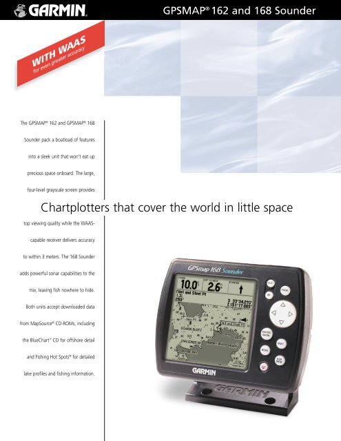
The GPSMAP ® <strong>162</strong> and GPSMAP ® <strong>168</strong><br />
Sounder pack a boatload of features<br />
into a sleek unit that won’t eat up<br />
precious space onboard. The large,<br />
four-level grayscale screen provides<br />
top viewing quality while the WAAS-<br />
capable receiver delivers accuracy<br />
to within 3 meters. The <strong>168</strong> Sounder<br />
adds powerful sonar capabilities to the<br />
mix, leaving fish nowhere to hide.<br />
Both units accept downloaded data<br />
from MapSource ® CD-ROMs, including<br />
the BlueChart CD for offshore detail<br />
and Fishing Hot Spots ® for detailed<br />
lake profiles and fishing information.<br />
GPSMAP ® <strong>162</strong> and <strong>168</strong> Sounder<br />
Chartplotters that cover the world in little space
specifications<br />
Navigation features<br />
Waypoints:<br />
Total: 500 alphanumeric<br />
Nearest: 10 (automatic)<br />
Proximity: 10 (definable)<br />
Routes: 20 reversible with up to 30 points each,<br />
plus MOB and TracBack modes<br />
Track log: Approx. 2,000 points<br />
Map datums: 106 plus user datum<br />
Coordinates: Lat/Lon, UTM/UPS, Loran TD, plus 10 grids,<br />
including Maidenhead<br />
Performance<br />
Receiver:<br />
Acquisition times:<br />
WAAS enabled, 12 parallel channel<br />
GPS receiver continuously tracks and<br />
uses up to 12 satellites to compute<br />
and update your position<br />
Warm: Approx. 15 seconds<br />
Cold: Approx. 45 seconds<br />
AutoLocate : Approx. 5 minutes<br />
Update rate:<br />
GPS accuracy:<br />
1/second, continuous<br />
Position: < 15 meters, 95% typical*<br />
Velocity:<br />
DGPS (USCG) accuracy:<br />
0.05 meter/sec steady state<br />
Position: 3-5 meters, 95% typical<br />
Velocity:<br />
DGPS (WAAS) accuracy:<br />
0.05 meter/sec steady state<br />
Position: < 3 meters, 95% typical<br />
Velocity: 0.05 meter/sec steady state<br />
Dynamics: 6g’s<br />
Interfaces: NMEA 0183 and<br />
RTCM 104 DGPS corrections<br />
Antenna: GA 29 remote marine mount with 30' cable<br />
Plotter/moving map features<br />
Basemap: Built-in basemap of the Americas to 20<br />
miles includes detailed ocean, river and<br />
lake coastlines, cities, interstates, US<br />
state highways and local thoroughfares<br />
Uploadable maps: Up to 2.5 megabytes of data<br />
(data is optional)<br />
Plotting scales: 120 feet to 800 nm with dedicated pushbutton<br />
zoom control<br />
GPSMAP <strong>168</strong> Sounder<br />
(shown with internal antenna)<br />
GPSMAP ® <strong>162</strong> and <strong>168</strong> Sounder<br />
Power<br />
Source: GPSMAP <strong>162</strong> = 10-40vDC<br />
GPSMAP <strong>168</strong> Sounder = 10-18vDC<br />
Usage: GPSMAP <strong>162</strong> = 4 watts max.<br />
GPSMAP <strong>168</strong> Sounder = 10 watts max.<br />
Physical<br />
Size: 4.63" H x 6.0" W x 2.75" D<br />
(11.7cm x 15.2cm x 7cm)<br />
Weight: 1 lb. 6 oz. (0.763 kg)<br />
Display: 4.2" diagonal (10.7cm) high-contrast,<br />
4-level gray LCD with backlighting<br />
(240 x 240 pixels)<br />
Case: Fully gasketed, high-impact plastic alloy,<br />
waterproof to IEC 529-IPX-7<br />
Temperature range: 5º F to 158º F (-15º C to 70º C)<br />
Accessories<br />
Standard: GPSmap <strong>162</strong> chartplotting receiver<br />
Remote antenna with 30' cable or bail<br />
mount antenna bracket (shown below)<br />
Power/data cable<br />
PC cable with AC adapter<br />
User’s manual<br />
Surface/flush mount bracket with knobs<br />
Quick start guide<br />
Transom mount transducer ** (<strong>168</strong> Sdr only)<br />
Optional: MapSource CDs:<br />
Fishing Hot Spots, ® BlueChart, Topo,<br />
U.S. Roads & Recreation, WorldMap,<br />
U.S. Waterways & Lights<br />
Beacon receiver for differential corrections<br />
Transducers in a wide variety of transom<br />
and thru-hull mounts<br />
Marine swivel mount – 1 inch RAM ®<br />
Quick release flush mount kit<br />
Depth Sounder features (GPSMAP <strong>168</strong> Sounder only)<br />
Frequency: 200 kHz<br />
Transmit power: 150 watts (RMS), 1200 watts (peak to peak)<br />
Display options: Auto bottom tracking, auto ranging,<br />
2X and 4X zoom levels, split screen<br />
feature, and 3-level fish ID<br />
Alarms: Fish and shallow/deep water<br />
GPSMAP <strong>162</strong> GPSMAP <strong>168</strong> Sounder<br />
REV1001 M01-10099-01<br />
Big numbers option shows your<br />
navigation status at a glance.<br />
View satellite and differential<br />
receiver status, along with your<br />
position, all on one page.<br />
Tide prediction capability is a feature<br />
on both the GPSMAP <strong>162</strong> and <strong>168</strong><br />
Sounder (U.S. and Canada only).<br />
©2001 GARMIN Corporation<br />
GARMIN International<br />
1200 East 151st Street<br />
Olathe, Kansas 66062, U.S.A.<br />
913/397.8200 fax 913/397.8282<br />
GARMIN (Europe) Ltd.<br />
Unit 5, The Quadrangle<br />
Abbey Park Industrial Estate<br />
Romsey, SO51 9AQ, U.K.<br />
44/1794.519944 fax 44/1794.519222<br />
GARMIN (Asia) Corporation<br />
No. 68, Jangshu 2nd Rd.<br />
Shijr, Taipei County, Taiwan<br />
886/2.2642.9199 fax 886/2.2642.9099<br />
www.garmin.com<br />
Specifications are preliminary and subject to change<br />
without notice.<br />
* Subject to accuracy degradation to 100m 2DRMS<br />
under the U.S. Department of Defense imposed<br />
Selective Availability Program.<br />
** Also available without a transducer.