Communiqué - Cal Fire - State of California
Communiqué - Cal Fire - State of California
Communiqué - Cal Fire - State of California

Create successful ePaper yourself
Turn your PDF publications into a flip-book with our unique Google optimized e-Paper software.
To cover the large number <strong>of</strong> Southern<br />
<strong>Cal</strong>ifornia wildfi res that occurred in late<br />
2007, the state formed seven BAER teams<br />
made up <strong>of</strong> representatives from CAL<br />
FIRE, <strong>Cal</strong>ifornia Geological Survey, Department<br />
<strong>of</strong> Water Resources, Department <strong>of</strong><br />
Fish and Game, Department <strong>of</strong> Parks and<br />
Recreation, and Regional Water Quality<br />
Control Boards. These teams consisted<br />
<strong>of</strong> engineers, geologists, hydrologists,<br />
foresters, biologists, botanists, archeologists<br />
and GIS experts.<br />
BAER Team members looked for threats<br />
to the public from landslides, mud fl ows,<br />
fl ooding, and road hazards. They also<br />
worked to identify risks to water quality,<br />
botanical and cultural resources, wildlife,<br />
and fi sheries. The teams determined<br />
whether measures were needed to<br />
prevent or mitigate identifi ed threats.<br />
Six state teams conducted assessments<br />
on the Santiago, Canyon, Rice, Witch/<br />
Poomacha, Harris, and Corral <strong>Fire</strong>s. An<br />
additional team was assembled for the<br />
remaining smaller fi res. Coordination and<br />
direction <strong>of</strong> the teams was provided by a<br />
Multi-Agency Support Group (MASG) that<br />
was led by the Federal Emergency Management<br />
Agency (FEMA) and the state<br />
Offi ce <strong>of</strong> Emergency Services (OES).<br />
The assessment process used by the<br />
BAER teams was similar on each <strong>of</strong> the<br />
2007 wildfi res.<br />
First, individual teams were assembled<br />
at the MASG Headquarters in San Bernardino<br />
County, where a CAL FIRE<br />
team leader was assigned. Each team<br />
received background information on their<br />
assigned fi re during an orientation<br />
session. Initial information included soil<br />
burn severity maps developed from satellite<br />
imagery and summary directions on<br />
how to conduct the assessment.<br />
After arriving at their assigned fi res in<br />
Orange, Los Angeles, San Bernardino,<br />
and San Diego Counties, the BAER teams<br />
identifi ed preliminary values-at-risk using<br />
maps and Google Earth imagery, including<br />
homes, highways, rail lines, businesses<br />
and water storage reservoirs. The teams<br />
then began more detailed fi eld investigations,<br />
particularly in areas with higher<br />
burn severity and identifi ed values-at-risk.<br />
Typical team recommendations included<br />
the need for detailed follow-up inspections<br />
at sites with a high risk to human life<br />
from landslides and mud fl ows and the<br />
use <strong>of</strong> rain gauge systems with telemetry<br />
to provide “early warning” for homeowner<br />
evacuations. Measures for protecting<br />
threatened or endangered (T/E) species<br />
and archeological sites were also recommended.<br />
The Santiago <strong>Fire</strong> in Orange County posed<br />
the biggest threat to human life, where<br />
extreme hazards exist for mud fl ows in<br />
Modjeska, Williams and Silverado Can-<br />
yons. By mid-December, evacuations had<br />
already been ordered twice in these areas<br />
as a result <strong>of</strong> post-fi re rainstorms.<br />
Several lessons were learned from<br />
the state BAER teams’ assessments.<br />
First, although the MASG eff ort was<br />
successful, improved coordination and<br />
communication is needed among the<br />
many state, local, and federal agencies<br />
that may be called upon to respond to<br />
future post-fi re assessments.<br />
Second, funding mechanisms and<br />
cost recovery plans need to be better<br />
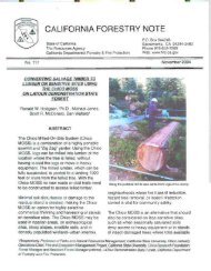
above: A Burned watershed from the Rice <strong>Fire</strong> in<br />
San Diego County around a water storage tank at<br />
the Red Mountain Reservoir.<br />
left: Houses evaluated for risk <strong>of</strong> mud slides below<br />
a burned steep drainage from the Rice <strong>Fire</strong> in San<br />
Diego County. Photo by Pete Caff erata.<br />
coordinated among all local, state and<br />
federal agencies that may be called upon<br />
to respond to these types <strong>of</strong> missions.<br />
Finally, if the <strong>State</strong> <strong>of</strong> <strong>Cal</strong>ifornia continues<br />
to conduct post-fi re assessment work on<br />
major wildfi res, training and funding is<br />
needed to prepare Emergency Response<br />
Incident Management Teams.<br />
All the state and federal BAER reports are posted on the<br />
following website: http://www.oes.ca.gov/Operational/OESHome.nsf/PrintView/6C9651A85E8E98D988257<br />
398007B899F?OpenDocument<br />
<strong>Communiqué</strong><br />
7