Communiqué - Cal Fire - State of California
Communiqué - Cal Fire - State of California
Communiqué - Cal Fire - State of California

Create successful ePaper yourself
Turn your PDF publications into a flip-book with our unique Google optimized e-Paper software.
In an eff ort to prevent loss <strong>of</strong> life and<br />
property due to landslides and mud fl ows,<br />
CAL FIRE joined many other state and<br />
federal agencies to conduct post-fi re<br />
Burned Area Emergency Response (BAER)<br />
assessments for the southern <strong>Cal</strong>ifornia<br />
fi res that occurred in late October and<br />
early November <strong>of</strong> last year.<br />
Overall, more than 90 state employees<br />
conducted BAER assessments on almost<br />
400,000 acres <strong>of</strong> state responsibility area<br />
(SRA) lands.<br />
These state assessments were conducted<br />
in response to Governor Schwarzenegger’s<br />
Executive Order (S-13-07) and were<br />
focused primarily on burned areas on or<br />
next to SRA lands. The U.S. Forest Service<br />
(USFS) and Department <strong>of</strong> Interior (DOI)<br />
conducted BAER assessments on federal<br />
lands.<br />
While the USFS has conducted multidisciplinary<br />
BAER assessments for several<br />
years, this is the fi rst time CAL FIRE has<br />
6 Spring 2008<br />
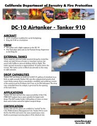
When the <strong>Fire</strong>’s Out, the Job’s not Done<br />
BAER Teams Protect Lives and Property<br />
By Pete Caff erata, Forest Hydrologist & John Munn, Soil Erosion Studies Project Leader, Sacramento Headquarters<br />
above: Rice <strong>Fire</strong> state BAER team examines burned<br />
watershed above Red Mountain Reservoir in San<br />
Diego County. Photo by Pete Caff erata.<br />
right: Dave Longstreth, <strong>Cal</strong>ifornia Geological Survey,<br />
views homes at risk in the Santiago <strong>Fire</strong> during a helicopter<br />
reconnaissance fl ight. Photo by Clay Brandow.<br />
undertaken post-fi re assessment work<br />
on such a large scale. A framework for<br />
the <strong>State</strong>’s response was provided by the<br />
post-fi re work on the Angora <strong>Fire</strong> in the<br />
Lake Tahoe Basin earlier in 2007.<br />
Post-fi re watershed rehabilitation has<br />
evolved considerably since the 1950’s,<br />
when annual rye grass was commonly<br />
spread by planes and helicopters on<br />
burned hill slopes. This practice continued<br />
through the 1980’s, but research<br />
conducted in the 1990’s showed that it is<br />
rarely eff ective in preventing surface erosion<br />
or mud fl ows.<br />
Current post-fi re assessments focus on<br />
identifying on-site and downstream threats<br />
to public health and safety, with less emphasis<br />
on preventing hill slope erosion.