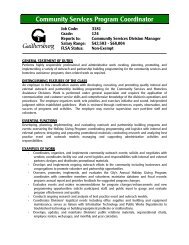
National Geographic Building - City of Gaithersburg
National Geographic Building - City of Gaithersburg
National Geographic Building - City of Gaithersburg

You also want an ePaper? Increase the reach of your titles
YUMPU automatically turns print PDFs into web optimized ePapers that Google loves.
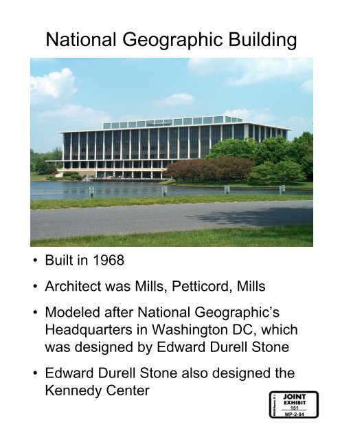
<strong>National</strong> <strong>Geographic</strong> <strong>Building</strong><br />
• Built in 1968<br />
• Architect was Mills, Petticord, Mills<br />
• Modeled after <strong>National</strong> <strong>Geographic</strong>’s<br />
Headquarters in Washington DC, which<br />
was designed by Edward Durell Stone<br />
• Edward Durell Stone also designed the<br />
Kennedy Center<br />
151<br />
MP-2-04
GE Technology Park<br />
Special Study Area
Process to Date<br />
• April 2004 - Stakeholders Meeting<br />
• June 2004 - Joint Work Session<br />
• September 2004 - Planning Commission Hearing<br />
• September 2004 – Mayor & Council Policy Discussion<br />
• December 2004 - Joint Public Hearing<br />
• February 2005 - Joint Work Session<br />
• November 2005 - Joint Work Session<br />
• January 2006 - Planning Commission Recommendation<br />
• March 2006 – Town Hall Meeting
Annexation Agreement<br />
X-146<br />
• <strong>National</strong> <strong>Geographic</strong><br />
Society requested<br />
annexation in 1989<br />
• Requested I-3 zoning<br />
designation<br />
• 40% Green space<br />
requirement, consistent<br />
with County’s C-P zoning<br />
• 25’ Green space buffer<br />
adjacent to MD Route 28<br />
• Amended in 2000<br />
• All previous requirements<br />
remained in effect<br />
• 700,000 square feet <strong>of</strong><br />
additional development<br />
permitted
Public Comments<br />
Stakeholders Meeting<br />
April 2004<br />
• Need to balance the amount <strong>of</strong> renters versus owners for<br />
residential housing<br />
• Will the existing buildings remain or will they be demolished?<br />
• Is the lake considered “green space”?<br />
• Traffic, schools, and open space will suffer if apartments are<br />
built<br />
• Assets include the lake and “modern” architecture <strong>of</strong> the former<br />
<strong>National</strong> <strong>Geographic</strong> building<br />
• Any development on the property should enhance the<br />
surrounding neighborhoods rather than detract from them<br />
• The 550,000 sq ft <strong>of</strong> additional development will likely be in the<br />
form <strong>of</strong> tall buildings and will potentially add 2500 daily trips on<br />
the roads<br />
• A knowledge-based industrial park would be desirable in this<br />
area<br />
• There are lots <strong>of</strong> parking lots now and 700,000 sq ft <strong>of</strong> more<br />
development will look better<br />
• A mixed-use development can add residents to support the<br />
commercial/retail area <strong>of</strong> Kentlands and Lakelands<br />
• The addition <strong>of</strong> houses and children may change the school<br />
boundaries<br />
• A skating rink and miniature golf would be nice to have in this<br />
area<br />
• More performing arts space would be nice and a shuttle to<br />
move people between this site and the Town Center<br />
• Where is the “green space” and what/where will it be?<br />
• Any new apartments that are constructed should be unique and<br />
have a niche<br />
• Additional retail and restaurant uses may compete against the<br />
Town Center
Public Comments<br />
Stakeholders Meeting<br />
April 2004<br />
• The lake adds to the character <strong>of</strong> the community and provides<br />
opportunities for fishing<br />
• A park or a mixed-residential and condominium development<br />
would be better than apartments<br />
• Is the warehouse staying or being removed?<br />
• The principals <strong>of</strong> Kentlands and Lakelands should be applied for<br />
any development on the GE Tech Park site<br />
• A Hotel would be nice<br />
• Some owners paid for the trees and the view and don’t want<br />
apartments in their view<br />
• A School site on GE Tech Park property? Elementary School?<br />
High School?<br />
• A mix <strong>of</strong> uses is preferable to a single-use.<br />
• Is there any “affordable housing” being proposed<br />
• A 9-hole golf course would be nice<br />
• Whatever happens on this site, the <strong>City</strong> should make sure it<br />
doesn’t add to traffic<br />
• There are many mature trees on the NGS property and they<br />
should not be cut down<br />
• Don’t put any development along MD 28<br />
• Few <strong>of</strong> the “live-work” townhouses in Kentlands/Lakelands are<br />
neighborhood stores and the owners usually don’t live there<br />
• There is a lack <strong>of</strong> <strong>of</strong>fice space in this general area to support the<br />
amount <strong>of</strong> restaurant and retail that is existing nearby<br />
• Apartments <strong>of</strong>ten end up isolated from the rest <strong>of</strong> the community<br />
• New apartments should be better integrated into the community<br />
• The <strong>City</strong> should maintain the “pristine” character <strong>of</strong> the property
Recommended Baseline Requirements<br />
• A community-based workshop shall be<br />
held prior to any Sketch or Concept Plan<br />
submission.<br />
• A minimum <strong>of</strong> 40% <strong>of</strong> the study area is<br />
required to be green space, with a<br />
minimum <strong>of</strong> 15% <strong>of</strong> the total green space<br />
requirement located within the<br />
developable areas.<br />
• All tree areas outside <strong>of</strong> the stream valley<br />
buffer and/or floodplain buffer should be<br />
retained as “priority” green space.<br />
• The existing tree buffer around Lake<br />
Placid shall be preserved.<br />
• A buffer shall be provided adjacent to the<br />
residences along Still Creek Lane.<br />
• All required environmental buffers shall<br />
be provided.<br />
• A street connection shall be provided<br />
between Main St and Edison Park Dr.<br />
• A pathway around Lake Placid and<br />
pathway connections to adjacent<br />
neighborhoods shall be provided.<br />
• Future development design should<br />
reduce the reliance on and the use <strong>of</strong><br />
automobiles.<br />
• Future development shall be compatible<br />
with the existing surrounding uses and<br />
natural environment.<br />
• An additional road connection to the<br />
Lakelands community from Edison Park<br />
Drive should be further reviewed and<br />
provided, if possible.<br />
• All annexation requirements shall be<br />
satisfied.<br />
• The views and vistas to the existing<br />
<strong>of</strong>fice building and natural landmarks<br />
shall be preserved.
Consistent Map Designations For All 4 Options<br />
Map Designation 1:<br />
• Lake Placid, Buffer around the Lake, green space between Lake and<br />
MD 28<br />
• Recommendation: preserve as green space, provide paths and<br />
connections to surrounding areas, place in open space easement<br />
• Proposed Land Use: recreation/open space<br />
Map Designation 2:<br />
• Lot 3, <strong>City</strong>-owned (Aquatic Center site)<br />
• Recommendation: public use, provide paths and connections to<br />
surrounding areas<br />
• Proposed Land Use: recreation<br />
Map Designation 3:<br />
• Stream Valley Buffer and buffer around Lake Edison<br />
• Recommendation: preserve as green space<br />
• Proposed Land Use: open space
Land Use Option 1<br />
Map Designation 4:<br />
Part <strong>of</strong> Lots 1 & 2 and part <strong>of</strong> Parcel C<br />
Recommendation: Office and research & development uses<br />
preferred rather than warehouse & industrial; provide buffer<br />
adjacent to Lakelands (Lane in the Woods); use proper planning<br />
and architectural design; first floors <strong>of</strong> buildings should have extra<br />
height to allow for incidental commercial uses; minimize surface<br />
parking; avoid additional stream valley crossing to access Parcel<br />
C, preserve as much forest on Parcel C as possible<br />
Proposed Land Use: <strong>of</strong>fice and research & development<br />
Special Conditions: none
Land Use Option 2<br />
Map Designation 4:<br />
Part <strong>of</strong> Lot 1 (includes former <strong>National</strong> <strong>Geographic</strong> building)<br />
Recommendation: Office and research & development uses<br />
preferred rather than warehouse & industrial; use proper planning<br />
and architectural design; first floors <strong>of</strong> buildings should have extra<br />
height to allow for incidental commercial uses; minimize surface<br />
parking<br />
Proposed Land Use: <strong>of</strong>fice and research & development<br />
Map Designation 5:<br />
Part <strong>of</strong> Lot 2 and part <strong>of</strong> Parcel C (warehouse and vacant lot)<br />
Recommendation: Single-family attached and detached units;<br />
provide buffer adjacent to Lakelands (Lane in the Woods); avoid<br />
additional stream valley crossing to access Parcel C, preserve as<br />
much forest on Parcel C as possible<br />
Proposed Land Use: low-medium density residential<br />
Special Condition:<br />
Residential development <strong>of</strong> the site shall be <strong>of</strong> comparable density<br />
and mix to the adjacent communities <strong>of</strong> Kentlands and Lakelands.
Land Use Option 3<br />
Map Designation 4:<br />
Part <strong>of</strong> Lot 1 (includes former <strong>National</strong> <strong>Geographic</strong> building)<br />
Recommendation: Primarily <strong>of</strong>fice, with some residential and<br />
commercial/retail uses; preferred residential uses are single family<br />
attached and detached units and 2-over-2 condos rather than<br />
multifamily residential; warehouse and industrial are not recommended;<br />
use proper planning and architectural design.<br />
Proposed Land Use: mixed <strong>of</strong>fice, residential, commercial/retail<br />
Map Designation 5:<br />
Part <strong>of</strong> Lot 2 and part <strong>of</strong> Parcel C (warehouse and vacant lot)<br />
Recommendation: Single-family attached and detached units; provide<br />
buffer adjacent to Lakelands (Lane in the Woods); avoid additional<br />
stream valley crossing to access Parcel C, preserve as much forest on<br />
Parcel C as possible<br />
Proposed Land Use: low-medium density residential<br />
Special Conditions:<br />
Residential development <strong>of</strong> Map Designation 4 shall be concurrent with<br />
the redevelopment <strong>of</strong> Map Designation 5 and part <strong>of</strong> a unified design.<br />
Residential development <strong>of</strong> the site shall be <strong>of</strong> comparable density and<br />
mix to the adjacent communities <strong>of</strong> Kentlands and Lakelands.
Land Use Option 4<br />
Map Designation 4:<br />
Part <strong>of</strong> Lot 1 (includes parking lots and recreation fields)<br />
Recommendation: Mix <strong>of</strong> residential uses; majority <strong>of</strong> residential uses should be<br />
single family attached/detached and 2-over-2 condos; multifamily only as a buffer to<br />
<strong>of</strong>fice core, middle school, and park; use proper planning and architectural design.<br />
Proposed Land Use: mixed residential<br />
Map Designation 5:<br />
Part <strong>of</strong> Lot 1 (includes former <strong>National</strong> <strong>Geographic</strong> building)<br />
Recommendation: Office and commercial/retail uses; warehouse and industrial<br />
uses are not recommended; use proper planning and architectural design.<br />
Proposed Land Use: mixed <strong>of</strong>fice and commercial/retail<br />
Map Designation 6:<br />
Part <strong>of</strong> Lot 2 and part <strong>of</strong> Parcel C (warehouse and vacant lot)<br />
Recommendation: Single-family attached and detached units; provide buffer<br />
adjacent to Lakelands (Lane in the Woods); avoid additional stream valley crossing<br />
to access Parcel C, preserve forest on Parcel C<br />
Proposed Land Use: low-medium density residential<br />
Special Conditions:<br />
Residential development <strong>of</strong> Map Designation 4 shall be concurrent with the<br />
redevelopment <strong>of</strong> Map Designation 6 and part <strong>of</strong> a unified design.<br />
Residential development <strong>of</strong> the site shall be <strong>of</strong> comparable density and mix to the<br />
adjacent communities <strong>of</strong> Kentlands and Lakelands.