Traveler Information Systems and Wayfinding Technologies in ...
Traveler Information Systems and Wayfinding Technologies in ...
Traveler Information Systems and Wayfinding Technologies in ...

You also want an ePaper? Increase the reach of your titles
YUMPU automatically turns print PDFs into web optimized ePapers that Google loves.
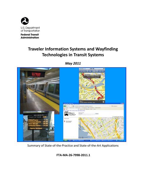
<strong>Traveler</strong> <strong>Information</strong> <strong>Systems</strong> <strong>and</strong> <strong>Wayf<strong>in</strong>d<strong>in</strong>g</strong><br />
<strong>Technologies</strong> <strong>in</strong> Transit <strong>Systems</strong><br />
May 2011<br />
Summary of State-of-the-Practice <strong>and</strong> State-of-the-Art Applications<br />
FTA-MA-26-7998-2011.1
Cover images (clockwise from upper left): Bay Area Rapid Transit’s Embarcadero Station vehicle arrival dynamic message sign<br />
(source: US DOT Volpe Center); Massachusetts Bay Transportation Authority’s Google Transit application (source: US DOT Volpe<br />
Center); Seattle’s One Bus Away Internet application (source: OneBusAway.org); Chapel Hill Transit Next Vehicle dynamic<br />
message sign (source: NextBus)
This page <strong>in</strong>tentionally left blank
REPORT DOCUMENTATION PAGE<br />
REPORT DOCUMENTATION PAGE<br />
Form Approved<br />
OMB No. 0704-0188<br />
Public report<strong>in</strong>g burden for this collection of <strong>in</strong>formation is estimated to average 1 hour per response, <strong>in</strong>clud<strong>in</strong>g the time for review<strong>in</strong>g <strong>in</strong>structions, search<strong>in</strong>g exist<strong>in</strong>g data sources,<br />
gather<strong>in</strong>g <strong>and</strong> ma<strong>in</strong>ta<strong>in</strong><strong>in</strong>g the data needed, <strong>and</strong> complet<strong>in</strong>g <strong>and</strong> review<strong>in</strong>g the collection of <strong>in</strong>formation. Send comments regard<strong>in</strong>g this burden estimate or any other aspect of this<br />
collection of <strong>in</strong>formation, <strong>in</strong>clud<strong>in</strong>g suggestions for reduc<strong>in</strong>g this burden, to Wash<strong>in</strong>gton Headquarters Services, Directorate for <strong>Information</strong> Operations <strong>and</strong> Reports, 1215 Jefferson Davis<br />
Highway, Suite 1204, Arl<strong>in</strong>gton, VA 22202-4302, <strong>and</strong> to the Office of Management <strong>and</strong> Budget, Paperwork Reduction Project (0704-0188), Wash<strong>in</strong>gton, DC 20503.<br />
1. AGENCY USE ONLY (Leave blank)<br />
2. REPORT DATE<br />
May 2011<br />
4. TITLE AND SUBTITLE<br />
<strong>Traveler</strong> <strong>Information</strong> <strong>Systems</strong> <strong>and</strong> <strong>Wayf<strong>in</strong>d<strong>in</strong>g</strong> <strong>Technologies</strong> <strong>in</strong> Transit <strong>Systems</strong>: Summary of State-of-the-<br />
Practice <strong>and</strong> State-of-the-Art<br />
6. AUTHOR(S)<br />
David W. Jackson; Charlotte Burger; Benjam<strong>in</strong> Cotton; Alex L<strong>in</strong>thicum; Luis Mejias; Terrance Regan; G<strong>in</strong>a<br />
Filosa<br />
7. PERFORMING ORGANIZATION NAME(S) AND ADDRESS(ES)<br />
U.S. Department of Transportation (U.S. DOT)<br />
Research <strong>and</strong> Innovative Technology Adm<strong>in</strong>istration (RITA)<br />
John A. Volpe National Transportation <strong>Systems</strong> Center<br />
55 Broadway/Cambridge, MA 02142<br />
9. SPONSORING/MONITORING AGENCY NAME(S) AND ADDRESS(ES)<br />
Federal Transit Adm<strong>in</strong>istration (FTA)<br />
Office of Mobility Innovation (TRI-10)<br />
Office of Research, Demonstration, <strong>and</strong> Innovation (TRI)<br />
1200 New Jersey Avenue, SE/Wash<strong>in</strong>gton, DC 20590<br />
11. SUPPLEMENTARY NOTES<br />
Available Onl<strong>in</strong>e [http://www.fta.dot.gov/research]<br />
12a. DISTRIBUTION/AVAILABILITY STATEMENT<br />
Available from National Technical <strong>Information</strong> Service (NTIS), 5285 Port Royal Road, Spr<strong>in</strong>gfield, VA<br />
22161. NTIS Sales Desk 1-800-553-6847 or (703) 605-6000; fax (703) 605-6900; TDD (703) 487-4639;<br />
Email [<strong>in</strong>fo@ntis.gov]<br />
3. REPORT TYPE AND DATES COVERED<br />
Technology Study <strong>and</strong> Recommendations<br />
5. FUNDING NUMBERS<br />
MA-26-7998-2011.1<br />
8. PERFORMING ORGANIZATION<br />
REPORT NUMBER<br />
FTA-MA-26-7998-2011.1<br />
10. SPONSORING/MONITORING<br />
AGENCY REPORT NUMBER<br />
FTA-MA-26-7998-2011.1<br />
12b. DISTRIBUTION CODE<br />
TRI-10<br />
13. ABSTRACT (Maximum 200 words)<br />
The purpose of the study is to provide federal guidance to transit agencies on current <strong>and</strong> future trends <strong>in</strong> the application of traveler <strong>in</strong>formation<br />
technologies as a means to exp<strong>and</strong> transit agencies deployments of these tools, which may result <strong>in</strong> an <strong>in</strong>crease <strong>in</strong> transit ridership. The study<br />
provides a technology evaluation that:<br />
• Offers an underst<strong>and</strong><strong>in</strong>g of wayf<strong>in</strong>d<strong>in</strong>g technologies <strong>and</strong> describes products <strong>and</strong> services.<br />
• Provides an overview of the benefits of these technologies <strong>and</strong> services for transit agencies <strong>and</strong> users.<br />
• Identifies challenges experienced by transit agencies regard<strong>in</strong>g the use <strong>and</strong> implementation of wayf<strong>in</strong>d<strong>in</strong>g technologies, <strong>and</strong> gaps that<br />
exist <strong>in</strong> current technologies.<br />
14. SUBJECT TERMS<br />
<strong>Wayf<strong>in</strong>d<strong>in</strong>g</strong>; <strong>Traveler</strong> <strong>Information</strong>; Intelligent Transportation <strong>Systems</strong>; ITS; ITS St<strong>and</strong>ards; Open<br />
Architecture; Open Source; Data<br />
17. SECURITY CLASSIFICATION<br />
OF REPORT<br />
Unclassified<br />
18. SECURITY CLASSIFICATION<br />
OF THIS PAGE<br />
Unclassified<br />
19. SECURITY CLASSIFICATION<br />
OF ABSTRACT<br />
Unclassified<br />
15. NUMBER OF PAGES<br />
139<br />
16. PRICE CODE<br />
20. LIMITATION OF ABSTRACT
TRAVELER INFORMATION SYSTEMS AND WAYFINDING<br />
TECHNOLOGIES IN TRANSIT SYSTEMS<br />
Summary of State-of-the-Practice <strong>and</strong> State-of-the-Art Applications<br />
May 2011<br />
Prepared by: U.S. DOT’s Research <strong>and</strong> Innovative Technology Adm<strong>in</strong>istration<br />
John A. Volpe National Transportation <strong>Systems</strong> Center<br />
Report # FTA-MA-26-7998-2011.1<br />
Sponsored by:<br />
Federal Transit Adm<strong>in</strong>istration<br />
Office of Mobility Innovation (TRI-10)<br />
Office of Research, Demonstration, <strong>and</strong> Innovation (TRI)<br />
1200 New Jersey Avenue, SE<br />
Wash<strong>in</strong>gton, DC 20590<br />
Available Onl<strong>in</strong>e<br />
http://www.fta.dot.gov/research
NOTICE/DISCLAIMER<br />
This document is dissem<strong>in</strong>ated under the sponsorship of the United<br />
States Department of Transportation <strong>in</strong> the <strong>in</strong>terest of <strong>in</strong>formation<br />
exchange. The United States Government assumes no liability for its<br />
contents or use thereof.<br />
The United States Government does not endorse products of<br />
manufacturers. Trademarks or manufacturers’ names appear <strong>in</strong> the<br />
document only because they are essential to the objective of the<br />
document.
Table of Contents<br />
Acronyms <strong>and</strong> Abbreviations ................................................................................................ ix<br />
Executive Summary ............................................................................................................... 1<br />
Epilogue ....................................................................................................................................... 4<br />
I. Introduction ................................................................................................................... 5<br />
Chapter 1. <strong>Wayf<strong>in</strong>d<strong>in</strong>g</strong> Primer ............................................................................................ 7<br />
1.1 Transit <strong>Information</strong> Content .......................................................................................... 12<br />
1.1.1 Station/Stop, Route, Schedule, <strong>and</strong> Fare Content................................................... 12<br />
1.1.2 Service Alerts ........................................................................................................... 13<br />
1.1.3 Real-Time Location .................................................................................................. 14<br />
1.1.4 Dest<strong>in</strong>ations ............................................................................................................ 16<br />
1.1.5 Vehicle Passenger Load Factor ............................................................................... 18<br />
1.2 Transit <strong>Information</strong> Format ............................................................................................ 19<br />
1.2.1 Maps ....................................................................................................................... 19<br />
1.2.2 Tables ...................................................................................................................... 21<br />
1.2.3 Text .......................................................................................................................... 22<br />
1.2.4 Audio ....................................................................................................................... 23<br />
1.2.5 Websites .................................................................................................................. 25<br />
1.2.6 Trip Planner ............................................................................................................. 27<br />
1.2.7 Electronic Messages ................................................................................................ 30<br />
1.3 Transit <strong>Information</strong> Delivery Media ............................................................................... 33<br />
1.3.1 Natural <strong>and</strong> Built Environment ............................................................................... 33<br />
1.3.2 Human Assistance ................................................................................................... 34<br />
1.3.3 Pr<strong>in</strong>ted Material ...................................................................................................... 35<br />
1.3.4 Customer Service Centers (Telephone) ................................................................... 36<br />
1.3.5 Signage .................................................................................................................... 37<br />
1.3.6 Public Announcement ............................................................................................. 41<br />
1.3.7 Personal Computer .................................................................................................. 42
1.3.8 Mobile Device .......................................................................................................... 43<br />
1.3.9 Transit Television .................................................................................................... 47<br />
1.3.10 Kiosks....................................................................................................................... 48<br />
1.4 Transit <strong>Wayf<strong>in</strong>d<strong>in</strong>g</strong> <strong>Technologies</strong> Summary ................................................................... 50<br />
Chapter 2. <strong>Wayf<strong>in</strong>d<strong>in</strong>g</strong> Deployments ................................................................................ 51<br />
2.1 Real-time <strong>Information</strong> .................................................................................................... 53<br />
2.2 Trip Planners................................................................................................................... 54<br />
2.3 Access<strong>in</strong>g <strong>Information</strong>: the Web; Cellular <strong>and</strong> Mobile Devices; Kiosks ......................... 55<br />
2.4 Data Shar<strong>in</strong>g ................................................................................................................... 55<br />
2.5 The State of the Future ................................................................................................... 56<br />
Chapter 3. Challenges <strong>and</strong> Recommendations .................................................................. 58<br />
3.1 Challenges ...................................................................................................................... 58<br />
3.1.1 Communication ....................................................................................................... 58<br />
3.1.2 Legal Challenges ..................................................................................................... 59<br />
3.1.3 Institutional Challenges .......................................................................................... 60<br />
3.1.4 Technical Challenges ............................................................................................... 62<br />
3.2 Recommendations ......................................................................................................... 66<br />
3.2.1 Lessons Learned ...................................................................................................... 66<br />
3.2.2 User Needs .............................................................................................................. 67<br />
3.3 Conclusion ...................................................................................................................... 68<br />
Appendix A. References .................................................................................................. 69<br />
Appendix B. <strong>Wayf<strong>in</strong>d<strong>in</strong>g</strong> Deployments Case Studies ........................................................ 76<br />
Appendix C. List of Agencies <strong>and</strong> Entities Interviewed ..................................................... 124<br />
Appendix D. Proposed Projects <strong>in</strong> the FTA ITS Research Plan – 2010-2014 ...................... 127<br />
Appendix E. Official Transit Social Media Sites............................................................... 136<br />
Appendix F. Timel<strong>in</strong>e of Regulatory Changes that Affect Private Radio <strong>Systems</strong> ............. 139
Acronyms <strong>and</strong> Abbreviations<br />
ADA Americans with Disabilities Act<br />
APC Automatic Passenger Counter<br />
API Application Programm<strong>in</strong>g Interface<br />
ATM Automated Teller Mach<strong>in</strong>es<br />
AVL Automatic Vehicle Location<br />
CAD Computer-aided dispatch<br />
DMS Dynamic Message Sign<br />
DOT Department of Transportation<br />
EFC Electronic Fare Collection<br />
EPD Electronic Paper Display<br />
GPS Global Position<strong>in</strong>g System<br />
GTFS General Transit Feed Specification (formerly Google Transit Feed Specification)<br />
ISP Internet Service Provider<br />
ITS Intelligent Transportation System<br />
IVR Interactive Voice Response<br />
LCD Liquid Crystal Display<br />
LED Light Emitt<strong>in</strong>g Diode<br />
LORAN Long Range Aid to Navigation<br />
MPO Metropolitan Plann<strong>in</strong>g Organization<br />
NFC Near Field Communication<br />
NYSDOT New York State Department of Transportation<br />
OSS Open Source Software<br />
OTS Off-the-Shelf<br />
PDA Personal Digital Assistants<br />
QR Quick Response [Code]<br />
RIAS Remote Infrared Audible Signage<br />
RSS Really Simple Syndication<br />
SIM Subscriber Identity Module<br />
SDP Schedule Data Profile<br />
SOA Service Oriented Architecture<br />
SMS Short Message Service, commonly known as Text Messag<strong>in</strong>g<br />
TTS Text-To-Speech<br />
WAP Wireless Access Po<strong>in</strong>t
Acronyms/Abbreviations for Transit Agencies Referenced<br />
AC Transit Alameda-Contra Costa Transit District (Oakl<strong>and</strong>, CA)<br />
AT Arl<strong>in</strong>gton Transit (Arl<strong>in</strong>gton, VA)<br />
BART Bay Area Rapid Transit District (Oakl<strong>and</strong>, CA)<br />
CalTra<strong>in</strong> Pen<strong>in</strong>sula Corridor Jo<strong>in</strong>t Powers Board (San Carlos, CA)<br />
CapMetro Capital Metropolitan Transportation Authority (Aust<strong>in</strong>, TX)<br />
CARTA Charleston Area Transportation Authority (Charleston, SC)<br />
CATA Capital Area Transit Authority (Lans<strong>in</strong>g, MI)<br />
CATA Centre Area Transportation Authority (State College, PA)<br />
CT Community Transit/Snohomish County Public Transportation Benefit Area<br />
Corporation (Everett, WA)<br />
CTA Chicago Transit Authority – RTA Service Board (Chicago, IL)<br />
CUE Fairfax CUE Bus System – City University Energy-Saver (Fairfax, VA)<br />
C-UMTD Champaign-Urbana Mass Transit District (Urbana, IL)<br />
DART Dallas Area Rapid Transit (Dallas, TX)<br />
DASH Alex<strong>and</strong>ria Transit Company (Alex<strong>and</strong>ria, VA)<br />
DTA Duluth Transit Authority (Duluth, MN)<br />
GoTriangle GoTriangle is a partnership of seven public transportation agencies <strong>in</strong> the<br />
Raleigh-Durham-Chapel Hill, NC Region<br />
HHA Hamburger Hochbahn AG/Hochbahn Rail Company (Hamburg, Germany)<br />
Houston Metro Metropolitan Transit Authority of Harris County (Houston, TX)<br />
KC Metro K<strong>in</strong>g County Metro/K<strong>in</strong>g County Department of Transportation (Seattle, WA)<br />
LACMTA Los Angeles County Metropolitan Transportation Authority (Los Angeles, CA)<br />
LTD Lane Transit District (Eugene, OR)<br />
MARTA Metropolitan Atlanta Rapid Transit Authority (Atlanta, GA)<br />
MBTA Massachusetts Bay Transportation Authority (Boston, MA)<br />
MCTS Milwaukee County Transit System (Milwaukee, WI)<br />
MDT Miami-Dade Transit (Miami, FL)<br />
Metra Northeast Ill<strong>in</strong>ois Regional Commuter Railroad Corporation – RTA Service<br />
Board (Chicago, IL)<br />
Metro Metro Transit (Madison, WI)<br />
MT Metro Transit/Tw<strong>in</strong> Cities Metropolitan Council (M<strong>in</strong>neapolis, MN)<br />
Metro Oregon Metro – Metropolitan Plann<strong>in</strong>g Organization (Portl<strong>and</strong>, OR)
MTA New York Metropolitan Transportation Authority (New York, NY)<br />
MTR Mass Transit Railway of Hong Kong (Ch<strong>in</strong>a)<br />
MTTA Metropolitan Tulsa Transit Authority/Tulsa Transit (Tulsa, OK)<br />
Muni San Francisco Municipal Railway (San Francisco, CA)<br />
NJ Transit New Jersey Transit Corporation (Newark, NJ)<br />
NS Dutch Railways/Nederl<strong>and</strong>se Spoorwegen (The Netherl<strong>and</strong>s)<br />
NTD Norwalk Transit District (Norwalk, CT)<br />
NYC Transit MTA New York City Transit (New York, NY)<br />
Pace Pace Suburban Bus Service – RTA Service Board (Arl<strong>in</strong>gton Heights, IL)<br />
PAAC Port Authority of Allegheny County (Pittsburgh, PA)<br />
PATH Port Authority Trans-Hudson Corporation (Jersey City, NJ)<br />
Pierce Transit Pierce County Transit/Pierce County Public Transportation Benefit Area<br />
Corporation (Tacoma, WA)<br />
PS Portl<strong>and</strong> Streetcar (Portl<strong>and</strong>, OR)<br />
RTA Greater Clevel<strong>and</strong> Regional Transit Authority (Clevel<strong>and</strong>, OH)<br />
RTA Regional Transportation Authority (Chicago, IL)<br />
RMV Rhe<strong>in</strong>-Ma<strong>in</strong>-Verkehrsverbund (Frankfurt, Germany)<br />
SamTrans San Mateo County Transit District (San Carlos, CA)<br />
SCTS Sioux City Transit System (Sioux City, IA)<br />
SEPTA Southeastern Pennsylvania Transportation Authority (Philadelphia, PA)<br />
Sound Transit Central Puget Sound Regional Transportation Authority (Seattle, WA)<br />
STM La Societe de Transport de Montreal (Montreal, Canada)<br />
Tokyo Metro Tokyo Metro/formerly Eidan - Teito Rapid Transit Authority (Tokyo, Japan)<br />
The T Fort Worth Transportation Authority (Fort Worth, TX)<br />
TriMet Tri-County Metropolitan Transportation District of Oregon (Portl<strong>and</strong>, OR)<br />
UTA Utah Transit Authority (Salt Lake City, UT)<br />
VRE Virg<strong>in</strong>ia Railway Express (Alex<strong>and</strong>ria, VA)<br />
VTA Santa Clara Valley Transportation Authority (San Jose, CA)<br />
WMATA Wash<strong>in</strong>gton Metropolitan Area Transit Authority (Wash<strong>in</strong>gton, D.C.)<br />
WSF Wash<strong>in</strong>gton State Ferries - Wash<strong>in</strong>gton State Department of Transportation<br />
(Seattle, WA)
This page <strong>in</strong>tentionally left blank
TRAVELER INFORMATION SYSTEMS AND WAYFINDING TECHNOLOGIES IN TRANSIT SYSTEMS<br />
Executive Summary<br />
PROJECT SUMMARY:<br />
The Federal Transit Adm<strong>in</strong>istration (FTA), Office of Mobility Innovation (TRI-10), has asked the<br />
USDOT’s Research <strong>and</strong> Innovative Technology Adm<strong>in</strong>istration’s (RITA) John A. Volpe National<br />
Transportation <strong>Systems</strong> Center (Volpe Center) to study <strong>and</strong> evaluate the <strong>in</strong>dustry <strong>and</strong> traveler<br />
benefits associated with transit wayf<strong>in</strong>d<strong>in</strong>g (the process of reach<strong>in</strong>g a dest<strong>in</strong>ation <strong>in</strong> a familiar<br />
or unfamiliar environment) <strong>and</strong> route <strong>in</strong>formation technologies.<br />
<strong>Wayf<strong>in</strong>d<strong>in</strong>g</strong> describes the process of reach<strong>in</strong>g a dest<strong>in</strong>ation, whether <strong>in</strong> a familiar or<br />
unfamiliar environment (KRW, 1996).<br />
<strong>Wayf<strong>in</strong>d<strong>in</strong>g</strong> technologies require the use of a wide range of exist<strong>in</strong>g <strong>and</strong> state-of-theart<br />
technological advances to provide travelers with <strong>in</strong>formation at three key stages of<br />
travel: pre-trip, en route, <strong>and</strong> at the station.<br />
The primary goal of this FTA study is to exp<strong>and</strong> the use <strong>and</strong> application of wayf<strong>in</strong>d<strong>in</strong>g<br />
technologies by the transit <strong>in</strong>dustry, which can <strong>in</strong> turn, help transit agencies <strong>in</strong>crease their<br />
ridership. This study conta<strong>in</strong>s:<br />
• A <strong>Wayf<strong>in</strong>d<strong>in</strong>g</strong> Primer (Chapter 1) that reviews various wayf<strong>in</strong>d<strong>in</strong>g elements, identified<br />
as basic technology, state-of-the-practice, state-of-the-art, or future technology. The<br />
primer was compiled from recent literature, web reviews, <strong>and</strong> transit agency phone <strong>and</strong><br />
on-site <strong>in</strong>terviews regard<strong>in</strong>g wayf<strong>in</strong>d<strong>in</strong>g or route <strong>in</strong>formation technologies that were<br />
conducted <strong>in</strong> 2009.<br />
• Summary of <strong>Wayf<strong>in</strong>d<strong>in</strong>g</strong> Deployments (Chapter 2) which <strong>in</strong>cludes opportunities,<br />
challenges, lessons, <strong>and</strong> recommendations to exp<strong>and</strong> the use of these technologies <strong>in</strong><br />
n<strong>in</strong>e metropolitan areas. Areas reviewed are (1) San Francisco, California, (2) Portl<strong>and</strong>,<br />
Oregon, (3) Seattle, Wash<strong>in</strong>gton, (4) Chicago, Ill<strong>in</strong>ois, (5) Houston, Dallas, <strong>and</strong> Aust<strong>in</strong>,<br />
Texas (6) Wash<strong>in</strong>gton, D.C., (7) New York City (New York – New Jersey). This chapter<br />
compiles <strong>in</strong>formation gathered dur<strong>in</strong>g phone <strong>and</strong> on-site <strong>in</strong>terviews with<br />
representatives of 63 public <strong>and</strong> private organizations across the nation.<br />
• Conclusions <strong>and</strong> Opportunities (Chapter 3) for deploy<strong>in</strong>g <strong>and</strong> utiliz<strong>in</strong>g an assortment of<br />
wayf<strong>in</strong>d<strong>in</strong>g technologies for transit services.<br />
FTA OFFICE OF MOBILITY INNOVATION /<br />
U.S. DOT RITA VOLPE CENTER MAY 2011
TRAVELER INFORMATION SYSTEMS AND WAYFINDING TECHNOLOGIES IN TRANSIT SYSTEMS<br />
SUMMARY OF KEY FINDINGS:<br />
(1) Technology Opportunities:<br />
• Real-time, quality data leads to better <strong>in</strong>formation at lower costs: With the availability<br />
<strong>and</strong> low cost of new wayf<strong>in</strong>d<strong>in</strong>g technologies, transit agencies are <strong>in</strong>creas<strong>in</strong>gly mov<strong>in</strong>g<br />
toward <strong>in</strong>formation delivery at all stages of travel. With the proliferation of systems<br />
that provide real-time vehicle arrival data or vehicle load capacities, the type of<br />
<strong>in</strong>formation available for display is exp<strong>and</strong><strong>in</strong>g beyond the traditional <strong>in</strong>formation, i.e.,<br />
schedules, fare, dest<strong>in</strong>ations, <strong>and</strong> service alerts. The design <strong>and</strong> delivery are also rapidly<br />
chang<strong>in</strong>g. Thus, transit agencies are actively seek<strong>in</strong>g to <strong>in</strong>corporate a wider breadth of<br />
newer <strong>and</strong> less expensive traveler <strong>in</strong>formation technologies.<br />
• New technologies allow for collaborative partnerships <strong>and</strong> dynamic markets: Transit<br />
agencies are becom<strong>in</strong>g savvier <strong>and</strong> th<strong>in</strong>k<strong>in</strong>g ahead with regard to advanced wayf<strong>in</strong>d<strong>in</strong>g<br />
technologies. For example, a wide variety of agencies are work<strong>in</strong>g with <strong>and</strong> mak<strong>in</strong>g<br />
their real-time data available to third party application developers, br<strong>in</strong>g<strong>in</strong>g new<br />
applications to transit customers on a variety of platforms. The proliferation of realtime<br />
transit <strong>in</strong>formation has the potential to significantly strengthen transit’s position to<br />
capture new riders by remov<strong>in</strong>g uncerta<strong>in</strong>ty <strong>in</strong> transit use.<br />
• New technologies allow for personalization: Third party applications are allow<strong>in</strong>g<br />
transit data to be used <strong>in</strong> a more personalized method <strong>and</strong> to reach a wider audience. A<br />
number of new efforts, such as mash-ups are also develop<strong>in</strong>g nicely, but their full<br />
impact is still under review. (Mash-ups are web applications that <strong>in</strong>tegrate data or<br />
functionality from one or more sources <strong>in</strong>to a s<strong>in</strong>gle application.)<br />
(2) Challenges <strong>in</strong> Implementation:<br />
• Legal: Transit agencies vary widely <strong>in</strong> their data shar<strong>in</strong>g policies. Ownership of real-time<br />
data, creation of user agreements, <strong>in</strong>tellectual property rights, <strong>and</strong> copyright or<br />
licens<strong>in</strong>g restrictions have arisen as the greatest legal challenges to develop<strong>in</strong>g <strong>and</strong><br />
ga<strong>in</strong><strong>in</strong>g full value from wayf<strong>in</strong>d<strong>in</strong>g technologies.<br />
• Institutional: Many transit agencies see traveler <strong>in</strong>formation as a trade-off between<br />
fund<strong>in</strong>g operations <strong>and</strong> ma<strong>in</strong>tenance activities or develop<strong>in</strong>g advanced real-time<br />
traveler <strong>in</strong>formation systems. In addition, a number of transit agencies lack resources or<br />
<strong>in</strong>ternal staff knowledge to develop <strong>and</strong> ma<strong>in</strong>ta<strong>in</strong> advanced wayf<strong>in</strong>d<strong>in</strong>g solutions. Even<br />
today, there is an <strong>in</strong>ternal resistance to utiliz<strong>in</strong>g advanced technologies, especially those<br />
that accurately track real-time performance.<br />
• Technical: Common technical challenges fac<strong>in</strong>g transit agencies <strong>in</strong> implement<strong>in</strong>g stateof-the-art<br />
wayf<strong>in</strong>d<strong>in</strong>g solutions fall <strong>in</strong>to several categories: data <strong>and</strong> systems <strong>in</strong>tegration,<br />
global position<strong>in</strong>g systems (accuracy <strong>and</strong> multiple antennae), data (st<strong>and</strong>ards, real-time,<br />
static), <strong>and</strong> obsolescence (piecemeal approach, proprietary systems, chang<strong>in</strong>g<br />
technology). The next major advancements are likely to occur <strong>in</strong> the development of<br />
FTA OFFICE OF MOBILITY INNOVATION /<br />
U.S. DOT RITA VOLPE CENTER 2 MAY 2011
TRAVELER INFORMATION SYSTEMS AND WAYFINDING TECHNOLOGIES IN TRANSIT SYSTEMS<br />
real-time data availability <strong>and</strong> data shar<strong>in</strong>g, <strong>in</strong> particular for emerg<strong>in</strong>g cooperative<br />
systems.<br />
(3) Lessons Learned:<br />
• Roll out real-time <strong>in</strong>formation systems slowly.<br />
• Use an <strong>in</strong>terdiscipl<strong>in</strong>ary team to design <strong>and</strong> develop wayf<strong>in</strong>d<strong>in</strong>g systems.<br />
• Include an evaluation component <strong>in</strong>to the implementation of wayf<strong>in</strong>d<strong>in</strong>g technologies<br />
to underst<strong>and</strong> how customers use them <strong>and</strong> assess effectiveness.<br />
(4) User Needs:<br />
In the <strong>in</strong>terviews, agencies identified needs for technical <strong>and</strong> policy guidance <strong>and</strong> best<br />
practices. Two of the most common needs are below.<br />
• Real-time data: Agencies expressed several needs, <strong>in</strong>clud<strong>in</strong>g guidance on shar<strong>in</strong>g realtime<br />
transit data <strong>and</strong> the development of real-time data st<strong>and</strong>ards.<br />
• Legal issues: Needs <strong>in</strong>cluded assistance <strong>in</strong> overcom<strong>in</strong>g legal issues <strong>in</strong>volved <strong>in</strong><br />
contract<strong>in</strong>g for customer <strong>in</strong>formation providers <strong>and</strong> guidance <strong>in</strong> open data issues.<br />
Prelim<strong>in</strong>ary f<strong>in</strong>d<strong>in</strong>gs from this 2009-2010 transit wayf<strong>in</strong>d<strong>in</strong>g <strong>and</strong> traveler <strong>in</strong>formation<br />
technology assessment were provided to FTA staff <strong>and</strong> proved <strong>in</strong>strumental <strong>in</strong> guid<strong>in</strong>g a<br />
number of the activities <strong>in</strong>cluded <strong>in</strong> the FTA’s ITS Research Plan – 2010-2014. Fifteen relevant<br />
transit wayf<strong>in</strong>d<strong>in</strong>g <strong>and</strong> traveler <strong>in</strong>formation projects were proposed <strong>and</strong> their eight topics are<br />
listed below. A full description of these proposed projects as they appear <strong>in</strong> the FTA’s ITS<br />
Research Plan – 2010-2014 are located <strong>in</strong> Appendix D.<br />
FTA OFFICE OF MOBILITY INNOVATION /<br />
U.S. DOT RITA VOLPE CENTER 3 MAY 2011
Epilogue<br />
TRAVELER INFORMATION SYSTEMS AND WAYFINDING TECHNOLOGIES IN TRANSIT SYSTEMS<br />
In the time s<strong>in</strong>ce the site visits, there have been advances <strong>in</strong> both the technology <strong>and</strong> its adoption <strong>and</strong> use for<br />
provid<strong>in</strong>g the rid<strong>in</strong>g public with <strong>in</strong>formation. Because of rapid evolution, agencies are tak<strong>in</strong>g even newer approaches<br />
to the <strong>in</strong>stitutional, legal, <strong>and</strong> technical challenges <strong>in</strong> shar<strong>in</strong>g data <strong>and</strong> <strong>in</strong>formation with the public. One of the more<br />
significant advances is the <strong>in</strong>clusion of Global Position<strong>in</strong>g <strong>Systems</strong> (GPS) <strong>in</strong>to smart phones that has triggered a<br />
proliferation of applications that comb<strong>in</strong>e maps, schedules, <strong>and</strong> locational services. Hundreds of these applications<br />
are now available to provide transit <strong>in</strong>formation us<strong>in</strong>g a variety of user <strong>in</strong>terfaces. Examples <strong>in</strong>clude:<br />
• The Chicago Transit Authority’s website provides status updates for its tra<strong>in</strong> l<strong>in</strong>es <strong>and</strong> bus routes; it also lists 13<br />
privately developed applications that provide transit system <strong>in</strong>formation. The applications <strong>in</strong>clude web, desktop,<br />
<strong>and</strong> mobile applications for smart phones <strong>and</strong> Blackberries. The website also <strong>in</strong>cludes <strong>in</strong>formation on how to<br />
<strong>in</strong>stall a do-it-yourself bus tracker display to display bus arrival times <strong>in</strong> a lobby or store.<br />
• The Metropolitan Transportation Authority-New York City Transit (MTA<br />
NYC Transit), the Massachusetts Bay Transportation Authority (MBTA),<br />
<strong>and</strong> the Wash<strong>in</strong>gton Metropolitan Area Transit Authority (WMATA) have<br />
shifted away from their previous restrictive policies concern<strong>in</strong>g shar<strong>in</strong>g of<br />
data <strong>and</strong> schedule <strong>in</strong>formation. As noted <strong>in</strong> the case study, it was<br />
formerly MTA policy to challenge the legality of the sale of a software<br />
application that used MTA Metro North data. The agency required a<br />
freedom of <strong>in</strong>formation request before provid<strong>in</strong>g quarterly schedule<br />
updates. With a change <strong>in</strong> leadership, the MTA now actively promotes the<br />
distribution of service <strong>in</strong>formation to the public. In January 2010, the MTA<br />
announced a new website that <strong>in</strong>cluded real time service status, as well as<br />
a new developers’ resource center where data is available to software<br />
developers to create applications.<br />
• In Massachusetts, both the State Department of Transportation <strong>and</strong> the<br />
MBTA now host a developers’ website. The MBTA now provides real time<br />
travel <strong>in</strong>formation for all of its 190 bus routes.<br />
• In 2010, WMATA <strong>in</strong>itiated its Transparent Metro Data Sets for Developers,<br />
a program to provide the general public <strong>and</strong> regional partners with access<br />
to data. It <strong>in</strong>cludes <strong>in</strong>formation on bus schedules, routes <strong>and</strong> stops, as<br />
well as metro rail arrival <strong>in</strong>formation <strong>and</strong> system <strong>in</strong>cidents. The program<br />
also <strong>in</strong>cludes feedback with external stakeholders. The stated vision of<br />
the program is to “make Metro transit data publicly available for the<br />
purpose of general transparency <strong>and</strong> of easily develop<strong>in</strong>g...other third party<br />
applications.” (WMATA Board <strong>Information</strong> Item IV-D, Customer Services,<br />
Operations, <strong>and</strong> Safety Committee 6.10.2010)<br />
“We need to get out of our own way<br />
<strong>and</strong> <strong>in</strong>stead get out <strong>in</strong> front of the<br />
data shar<strong>in</strong>g revolution. By mak<strong>in</strong>g<br />
access to our data directly from our<br />
website, we are encourag<strong>in</strong>g the<br />
developer community to do the work<br />
we can’t to create applications for<br />
transit riders, at no additional cost to<br />
the agency.”<br />
Jay Walder<br />
MTA General Manager<br />
MTA Press Release, 1.13.2010<br />
Regard<strong>in</strong>g previous reticence to<br />
share <strong>in</strong>formation with the public,<br />
Jeffrey Mullan, Secretary of MassDOT,<br />
was quoted say<strong>in</strong>g, “Those days are<br />
over. What the open-data <strong>in</strong>itiative<br />
has done is permitted people who are<br />
‘outside of transportation’ to help us<br />
perform our core mission. Even just<br />
lett<strong>in</strong>g people have access to our data<br />
proves to people that we’re will<strong>in</strong>g to<br />
trust others.”<br />
Boston Globe, 4.7. 2010 “T taps techsavvy<br />
to keep riders <strong>in</strong> loop”<br />
It is expected that this field will cont<strong>in</strong>ue to evolve rapidly, creat<strong>in</strong>g benefits for both transit agencies <strong>and</strong> their<br />
customers. The speed of change, however, requires that agencies cont<strong>in</strong>ue to grapple with legal, <strong>in</strong>stitutional, <strong>and</strong><br />
technical challenges to technology adoption <strong>and</strong> use.<br />
FTA OFFICE OF MOBILITY INNOVATION /<br />
U.S. DOT RITA VOLPE CENTER 4 MAY 2011
TRAVELER INFORMATION SYSTEMS AND WAYFINDING TECHNOLOGIES IN TRANSIT SYSTEMS<br />
Introduction<br />
Transportation-related <strong>in</strong>formation technologies—<strong>in</strong>clud<strong>in</strong>g those <strong>in</strong>stalled <strong>in</strong> vehicles, on<br />
personal mobile devices, or as part of the <strong>in</strong>frastructure—have grown significantly <strong>in</strong> the past<br />
several years, lead<strong>in</strong>g to <strong>in</strong>creased consumer expectations for easily accessible <strong>and</strong><br />
<strong>in</strong>stantaneous traveler <strong>in</strong>formation. Many transit agencies have lagged <strong>in</strong> dissem<strong>in</strong>at<strong>in</strong>g transit<br />
<strong>in</strong>formation <strong>in</strong> a manner compatible with the needs <strong>and</strong> expectations of the public. For<br />
example, many transit agencies track vehicles with Automatic Vehicle Location (AVL) systems, but<br />
do not process the <strong>in</strong>formation to provide next bus arrival predictions, which could be<br />
transmitted via websites, smart phones, or text message to customers en route, or wait<strong>in</strong>g at<br />
transit stations. Or an agency may track vehicles <strong>and</strong> make the <strong>in</strong>formation available on a<br />
website, but not make the <strong>in</strong>formation accessible <strong>in</strong> a format that can be read on a smart<br />
phone. Where transit agencies have not kept pace with advances <strong>in</strong> technology, this delay<br />
represents missed opportunities to leverage the benefits these technologies provide both for<br />
meet<strong>in</strong>g the <strong>in</strong>formation needs of current transit customers, <strong>and</strong> for potentially attract<strong>in</strong>g new<br />
customers.<br />
In support of the Federal Transit Adm<strong>in</strong>istration’s (FTA) Office of Mobility <strong>and</strong> Innovation, a<br />
team from the U.S. Department of Transportation’s (USDOT) John A. Volpe National<br />
Transportation <strong>Systems</strong> Center (Volpe Center) was charged with study<strong>in</strong>g <strong>and</strong> evaluat<strong>in</strong>g transit<br />
wayf<strong>in</strong>d<strong>in</strong>g <strong>and</strong> route <strong>in</strong>formation technologies <strong>and</strong> strategies. The purpose of the study is to<br />
provide an assessment of current <strong>and</strong> future trends <strong>in</strong> the application of traveler <strong>in</strong>formation<br />
technologies as a means to exp<strong>and</strong> transit agencies’ deployments of these tools, which may<br />
result <strong>in</strong> an <strong>in</strong>crease <strong>in</strong> transit ridership.<br />
The ma<strong>in</strong> product of this study is a technology evaluation that:<br />
• Offers an underst<strong>and</strong><strong>in</strong>g of wayf<strong>in</strong>d<strong>in</strong>g/route <strong>in</strong>formation products <strong>and</strong> services.<br />
• Provides an overview of the benefits of these technologies <strong>and</strong> services for transit<br />
agencies <strong>and</strong> users.<br />
• Identifies challenges experienced by transit agencies regard<strong>in</strong>g the use <strong>and</strong><br />
implementation of wayf<strong>in</strong>d<strong>in</strong>g technologies, <strong>and</strong> gaps that exist <strong>in</strong> current<br />
technologies.<br />
• Identifies user needs to achieve broader deployment of wayf<strong>in</strong>d<strong>in</strong>g technologies by<br />
transit agencies.<br />
This report is organized <strong>in</strong>to three ma<strong>in</strong> sections:<br />
• Chapter 1: <strong>Wayf<strong>in</strong>d<strong>in</strong>g</strong> Primer reviews the current state of the practice, the state of<br />
the art, <strong>and</strong> the potential for the future use of wayf<strong>in</strong>d<strong>in</strong>g technologies at national<br />
<strong>and</strong> <strong>in</strong>ternational transit agencies.<br />
• Chapter 2: <strong>Wayf<strong>in</strong>d<strong>in</strong>g</strong> Deployment summarizes experiences with wayf<strong>in</strong>d<strong>in</strong>g<br />
technology deployments <strong>in</strong> select metropolitan areas <strong>and</strong> by lead<strong>in</strong>g transit<br />
agencies.<br />
FTA OFFICE OF MOBILITY INNOVATION /<br />
U.S. DOT RITA VOLPE CENTER 5 MAY 2011
TRAVELER INFORMATION SYSTEMS AND WAYFINDING TECHNOLOGIES IN TRANSIT SYSTEMS<br />
• Chapter 3: Conclusions <strong>and</strong> Opportunities identifies challenges to overcome <strong>and</strong><br />
offers suggestions for both federal <strong>and</strong> local agencies to exp<strong>and</strong> wayf<strong>in</strong>d<strong>in</strong>g<br />
applications <strong>and</strong> deployments.<br />
The research f<strong>in</strong>d<strong>in</strong>gs <strong>and</strong> conclusions presented <strong>in</strong> this report were <strong>in</strong>formed by the follow<strong>in</strong>g<br />
sources:<br />
• Literature reviews <strong>and</strong> Internet searches: The team <strong>in</strong>vestigated exist<strong>in</strong>g wayf<strong>in</strong>d<strong>in</strong>g<br />
research, deployments, <strong>and</strong> identified lead<strong>in</strong>g transit agencies <strong>in</strong> the field. <strong>Information</strong><br />
from this review <strong>in</strong>formed the development of Chapter 1, <strong>Wayf<strong>in</strong>d<strong>in</strong>g</strong> Primer. See<br />
Appendix A for a bibliography <strong>and</strong> summary of sources.<br />
• Telephone <strong>in</strong>terviews: The team <strong>in</strong>terviewed public <strong>and</strong> private transportation agencies<br />
identified as be<strong>in</strong>g leaders <strong>in</strong> the <strong>in</strong>novative use of transit wayf<strong>in</strong>d<strong>in</strong>g technologies. The<br />
purpose was to collect <strong>in</strong>formation on the use <strong>and</strong> application of wayf<strong>in</strong>d<strong>in</strong>g<br />
technologies, underst<strong>and</strong> the associated challenges of wayf<strong>in</strong>d<strong>in</strong>g technologies, assess<br />
agency needs, <strong>and</strong> determ<strong>in</strong>e the most appropriate field locations for on-site <strong>in</strong>terviews.<br />
• On-site <strong>in</strong>terviews: The team built upon the <strong>in</strong>formation collected from <strong>in</strong>itial telephone<br />
<strong>in</strong>terviews to provide a greater depth of analysis regard<strong>in</strong>g the successful deployment of<br />
transit wayf<strong>in</strong>d<strong>in</strong>g technologies. In many cases, Volpe Center staff were able to meet<br />
<strong>in</strong>dividually with employees from different discipl<strong>in</strong>es with<strong>in</strong> the same organization. For<br />
example, when meet<strong>in</strong>g with transit agencies, staff from operations <strong>and</strong> ma<strong>in</strong>tenance,<br />
<strong>in</strong>formation technology, or market<strong>in</strong>g were asked about their respective views <strong>and</strong><br />
underst<strong>and</strong><strong>in</strong>g of transit wayf<strong>in</strong>d<strong>in</strong>g technologies <strong>and</strong> related issues. These face-to-face<br />
meet<strong>in</strong>gs, coupled with h<strong>and</strong>s-on use of, or demonstration of specific technologies by<br />
agencies, provided perspectives <strong>and</strong> <strong>in</strong>sights not available by telephone.<br />
A total of 63 public <strong>and</strong> private organizations from across the nation, <strong>in</strong>clud<strong>in</strong>g transit agencies,<br />
state departments of transportation, university research centers, software developers,<br />
metropolitan plann<strong>in</strong>g organizations, <strong>and</strong> others were <strong>in</strong>terviewed as part of this study. Two<br />
<strong>in</strong>terview guides, one for transit agencies <strong>and</strong> one for wayf<strong>in</strong>d<strong>in</strong>g technology application<br />
developers <strong>and</strong> service providers, were employed. The former <strong>in</strong>cludes questions related to<br />
wayf<strong>in</strong>d<strong>in</strong>g markets, current products <strong>and</strong> services used for wayf<strong>in</strong>d<strong>in</strong>g/route <strong>in</strong>formation,<br />
product development, data shar<strong>in</strong>g, the value <strong>and</strong> benefits of wayf<strong>in</strong>d<strong>in</strong>g products <strong>and</strong> services,<br />
costs, challenges <strong>and</strong> needs, future direction, <strong>and</strong> other topics. The latter <strong>in</strong>cludes questions<br />
related to bus<strong>in</strong>ess arrangements, the future direction of wayf<strong>in</strong>d<strong>in</strong>g technologies, <strong>and</strong> other<br />
topics. Additionally, Volpe Center staff visited seven major metropolitan areas where transit<br />
agencies were identified as leaders <strong>in</strong> the <strong>in</strong>novative use of transit wayf<strong>in</strong>d<strong>in</strong>g technologies. The<br />
full list of <strong>in</strong>terviewees can be found <strong>in</strong> Appendix C.<br />
FTA OFFICE OF MOBILITY INNOVATION /<br />
U.S. DOT RITA VOLPE CENTER 6 MAY 2011
TRAVELER INFORMATION SYSTEMS AND WAYFINDING TECHNOLOGIES IN TRANSIT SYSTEMS<br />
Chapter 1. <strong>Wayf<strong>in</strong>d<strong>in</strong>g</strong> Primer<br />
This chapter describes various wayf<strong>in</strong>d<strong>in</strong>g elements, categorized as basic technology, state-ofthe-practice,<br />
state-of-the-art, or future technology. It was compiled from recent literature, web<br />
reviews, <strong>and</strong> transit agency phone <strong>in</strong>terviews conducted <strong>in</strong> the first half of 2009 regard<strong>in</strong>g<br />
wayf<strong>in</strong>d<strong>in</strong>g/route <strong>in</strong>formation technologies.<br />
<strong>Wayf<strong>in</strong>d<strong>in</strong>g</strong> describes the process of reach<strong>in</strong>g a dest<strong>in</strong>ation, whether <strong>in</strong> a familiar or unfamiliar<br />
environment (KRW, 1996). <strong>Wayf<strong>in</strong>d<strong>in</strong>g</strong> consists of three stages (TTI <strong>and</strong> NuStats, 1999):<br />
Stage 1: A person identifies l<strong>and</strong>marks <strong>and</strong> beg<strong>in</strong>s to orient him or herself us<strong>in</strong>g the<br />
l<strong>and</strong>marks as references.<br />
Stage 2: L<strong>and</strong>mark knowledge develops <strong>in</strong>to route knowledge. The person builds travel<br />
directions with<strong>in</strong> the framework of familiar l<strong>and</strong>marks <strong>and</strong> visualizes travel plans as a<br />
series of actions that take him or her from an orig<strong>in</strong> to a dest<strong>in</strong>ation.<br />
Stage 3: After ga<strong>in</strong><strong>in</strong>g navigational experience <strong>in</strong> a particular environment, a person develops<br />
survey knowledge of the environment <strong>in</strong>clud<strong>in</strong>g l<strong>and</strong>marks, routes, <strong>and</strong> approximate<br />
travel costs between orig<strong>in</strong>s <strong>and</strong> dest<strong>in</strong>ations.<br />
<strong>Traveler</strong> <strong>in</strong>formation systems provide transit customers with the knowledge needed to<br />
facilitate <strong>and</strong> accelerate the wayf<strong>in</strong>d<strong>in</strong>g process. <strong>Traveler</strong> <strong>in</strong>formation systems <strong>and</strong><br />
accompany<strong>in</strong>g technologies that deliver <strong>in</strong>formation may help <strong>in</strong>dividuals to better plan transit<br />
trips <strong>and</strong> decrease frustrations or barriers associated with transit use, especially for new or<br />
unfamiliar transit riders (Multisystems, Inc., 2003).<br />
Three key elements of wayf<strong>in</strong>d<strong>in</strong>g technology <strong>and</strong> applications are:<br />
1) <strong>Information</strong> Content: <strong>Traveler</strong>s require transit <strong>in</strong>formation to underst<strong>and</strong> <strong>and</strong> navigate<br />
a transit system. Additional <strong>in</strong>formation can improve customer experience. For<br />
example, location of transit stops is vital <strong>in</strong>formation for a transit user. Accurate<br />
location of transit vehicles themselves further improves customer experience.<br />
2) <strong>Information</strong> Format: Transit <strong>in</strong>formation can be organized <strong>in</strong> several formats to<br />
facilitate communication with transit users. For example, <strong>in</strong>formation about stops <strong>and</strong><br />
vehicles can be presented as a table, map, or text.<br />
3) <strong>Information</strong> Delivery Media: Providers can convey transit <strong>in</strong>formation to customers<br />
through a variety of media, <strong>in</strong>clud<strong>in</strong>g pr<strong>in</strong>t, onl<strong>in</strong>e, displayed on dynamic message signs,<br />
or accessed via mobile devices.<br />
FTA OFFICE OF MOBILITY INNOVATION /<br />
U.S. DOT RITA VOLPE CENTER 7 MAY 2011
TRAVELER INFORMATION SYSTEMS AND WAYFINDING TECHNOLOGIES IN TRANSIT SYSTEMS<br />
Recent technological advances <strong>in</strong> these three<br />
components are chang<strong>in</strong>g the nature of wayf<strong>in</strong>d<strong>in</strong>g for<br />
transit travelers <strong>and</strong> transit managers. New mobile<br />
technologies allow for en route decision mak<strong>in</strong>g <strong>and</strong>,<br />
thus, chang<strong>in</strong>g the nature of the transit experience.<br />
Further advances <strong>in</strong> <strong>in</strong>teroperability are support<strong>in</strong>g<br />
advances <strong>in</strong> content, format, <strong>and</strong> delivery—mak<strong>in</strong>g it<br />
easier to access <strong>and</strong> use multi-source data, facilitat<strong>in</strong>g<br />
multi-modal connections.<br />
The rema<strong>in</strong>der of this chapter def<strong>in</strong>es how the<br />
wayf<strong>in</strong>d<strong>in</strong>g elements are employed <strong>and</strong> used <strong>in</strong><br />
different contexts depend<strong>in</strong>g on their level of<br />
technology or the particular desired use <strong>and</strong> strategy.<br />
Examples of technologies are provided, along with<br />
examples of how agencies or companies are<br />
promot<strong>in</strong>g their usage, 1<br />
<strong>and</strong> any foreseeable<br />
challenges, if they exist, to the widespread<br />
development <strong>and</strong> deployment of the technology, are<br />
noted.<br />
St<strong>and</strong>ards<br />
St<strong>and</strong>ards <strong>in</strong>crease <strong>in</strong>teroperability<br />
between devices <strong>and</strong> between transit<br />
providers <strong>and</strong> their customers.<br />
St<strong>and</strong>ards are a key component of<br />
<strong>in</strong>teroperability. FTA, with the<br />
American Public Transportation<br />
Association (APTA), has worked to<br />
develop <strong>and</strong> promote Transit<br />
Communications Interface Profiles<br />
(TCIP), through the USDOT ITS<br />
st<strong>and</strong>ards development program. TCIP<br />
provides a st<strong>and</strong>ard approach to<br />
exchang<strong>in</strong>g key <strong>in</strong>formation needed by<br />
<strong>in</strong>formation technology systems<br />
deployed by public transport agencies.<br />
Other non-st<strong>and</strong>ard formats are also <strong>in</strong><br />
use by transit agencies.<br />
Tables 1, 2, <strong>and</strong> 3 on the follow<strong>in</strong>g two pages provide a summary of the wayf<strong>in</strong>d<strong>in</strong>g elements,<br />
uses, strategies, <strong>and</strong> levels of technology. The levels of technology <strong>in</strong>clude a progression from<br />
basic technology to state-of-the-practice, state-of-the-art, <strong>and</strong> future technology. The tables<br />
also identify the trip stages for which each element is feasible or useful. Trip stages are def<strong>in</strong>ed<br />
as: pre-trip (PT), at-station (AS), en route (ER), <strong>and</strong> all stages (ALL). The tables also show that<br />
despite advancements <strong>in</strong> technologies, some basic technologies rema<strong>in</strong> important (<strong>and</strong> costeffective)<br />
at each successive stage. For example, static signage as a basic element of transit<br />
wayf<strong>in</strong>d<strong>in</strong>g strategies will likely rema<strong>in</strong> an important feature <strong>in</strong> future transit systems.<br />
1 Citation of any specific product or private entity does not imply endorsement by the federal government, U.S.<br />
DOT, FTA or the authors. Likewise, any omission of a product or private entity should not be assumed as a<br />
negative connotation on that product or private entity by the federal government. Agencies, products <strong>and</strong> private<br />
entities have been <strong>in</strong>cluded as a result of <strong>in</strong>terviews <strong>and</strong> document reviews, which was a thorough, but not allencompass<strong>in</strong>g<br />
research endeavor.<br />
FTA OFFICE OF MOBILITY INNOVATION /<br />
U.S. DOT RITA VOLPE CENTER 8 MAY 2011
USING TRAVELER INFORMATION SYSTEMS TO FACILITATE WAYFINDING IN TRANSIT SYSTEMS<br />
Table 1: <strong>Wayf<strong>in</strong>d<strong>in</strong>g</strong> strategies by level of technology (<strong>in</strong>formation delivery media)<br />
Uses BASIC STATE-OF-THE-PRACTICE STATE-OF-THE-ART FUTURE<br />
Natural & Built<br />
L<strong>and</strong>marks<br />
Signage<br />
Public<br />
Announcement<br />
Telephone<br />
Human<br />
Assistance<br />
Pr<strong>in</strong>ted<br />
Materials<br />
Personal<br />
Computer<br />
Built environment<br />
(architectural design)<br />
(ER, AS)<br />
Signage – static fixed<br />
signage (ER, AS)<br />
Signage – dynamic <strong>and</strong> mobile<br />
signage (ER, AS)<br />
Live voice (ER, AS) Recorded voice (ER, AS)<br />
L<strong>and</strong>l<strong>in</strong>e to Customer<br />
Service Center (PT)<br />
Human assistance (ER,<br />
AS)<br />
Pr<strong>in</strong>ted materials (ALL)<br />
Networked –<br />
stationary (PT)<br />
Cellular access to live <strong>and</strong><br />
automated Customer Service<br />
Center (ALL)<br />
Mobile Device Non-networked (ALL)<br />
Transit<br />
Television<br />
Kiosk Non-networked (AS)<br />
Trip Stages: Pre-Trip (PT), En Route (ER), At-station/Stop (AS), All Trip Stages (ALL)<br />
Remote Infrared Audible<br />
Signage (RIAS) (AS)<br />
Automated – text-tospeech<br />
(ER, AS)<br />
Interactive Voice Response<br />
(IVR) (ALL)<br />
Networked – mobile (ALL)<br />
Networked – centralized<br />
(ALL)<br />
Quick Response (QR)<br />
codes (ER, AS)<br />
Global Position<strong>in</strong>g <strong>Systems</strong><br />
(GPS) (ER, AS)<br />
St<strong>and</strong>ardized architectural<br />
design elements of new or<br />
remodeled transit stations<br />
(ER, AS)<br />
Networked – decentralized<br />
(ALL)<br />
Transit TV (ER, AS) Personalized TV (ER)<br />
Networked – <strong>in</strong>teractive<br />
(AS)<br />
FTA OFFICE OF MOBILITY INNOVATION/U.S. DOT RITA VOLPE CENTER 9 MAY 2011
USING TRAVELER INFORMATION SYSTEMS TO FACILITATE WAYFINDING IN TRANSIT SYSTEMS<br />
Table 2: <strong>Wayf<strong>in</strong>d<strong>in</strong>g</strong> strategies by level of technology (<strong>in</strong>formation content)<br />
Uses Basic State-Of-The-Practice State-Of-The-Art Future<br />
Routes Routes (ALL) Route choices/Best route (PT) Real-time route <strong>in</strong>fo (ALL)<br />
Stations/Stops Stations/stops (ALL) Station access (ALL)<br />
Fare Schedules (ALL)<br />
Elevator/escalator station<br />
Travel mode & route fare/cost options<br />
– F<strong>in</strong>ancial Comparisons (PT)<br />
F<strong>in</strong>ancial Comparisons (PT)<br />
Service Alerts<br />
access (ALL)<br />
Signage/oral <strong>in</strong>structions<br />
(AS)<br />
Service alerts (ALL) Customized service alerts (ALL)<br />
Real-Time Location Self (ER, AS) Transit vehicles (ER, AS) All vehicles (ALL)<br />
Dest<strong>in</strong>ations Station/stop names (ALL)<br />
Non-<strong>in</strong>tegrated (PT)<br />
L<strong>and</strong>marks/Po<strong>in</strong>ts of Interests (PT)<br />
Integrated (ALL)<br />
Vehicle Passenger<br />
Load<br />
Seasonal surveys (PT) Us<strong>in</strong>g APC for plann<strong>in</strong>g (PT)<br />
Vehicle passenger load available<br />
to passenger (ALL)<br />
Trip Stages: Pre-Trip (PT), En Route (ER), At-station/Stop (AS), All Trip Stages (ALL)<br />
FTA OFFICE OF MOBILITY INNOVATION/U.S. DOT RITA VOLPE CENTER 10 MAY 2011
USING TRAVELER INFORMATION SYSTEMS TO FACILITATE WAYFINDING IN TRANSIT SYSTEMS<br />
Table 3: <strong>Wayf<strong>in</strong>d<strong>in</strong>g</strong> strategies by level of technology (<strong>in</strong>formation format)<br />
Uses Basic State-Of-The-Practice State-Of-The-Art Future<br />
Map Hardcopy map (ALL) Personalized: Web-based (PT)<br />
Personalized: Mobile Device<br />
(ALL)<br />
Table Table (ALL) Dynamic Table (ALL)<br />
Text Text (ALL) Dynamic Text (ALL)<br />
Audio<br />
Customer Service Center<br />
(PT)<br />
Operator/Station public<br />
address (ER, AS)<br />
508 Compliant website & read<strong>in</strong>g<br />
software (PT)<br />
ADA-Required In-Vehicle/Station stop<br />
announcements (ER, AS)<br />
Station direction from Remote<br />
Infrared Audible Signage<br />
(RIAS) (AS)<br />
Website<br />
Website – static<br />
<strong>in</strong>formation (PT)<br />
Website – dynamic <strong>in</strong>formation (PT)<br />
Website – frequent updates<br />
(ALL)<br />
Trip Planner<br />
S<strong>in</strong>gle mode – static <strong>and</strong> non real-time<br />
(PT)<br />
Multimodal <strong>and</strong>/or real-time<br />
(ALL)<br />
E-mail (PT)<br />
E-mail (ALL)<br />
Electronic Message<br />
Really Simple Syndication (RSS) (PT) Really Simple Syndication<br />
Short Message Service (SMS) (ALL) (RSS) (ALL)<br />
Trip Stages: Pre-Trip (PT), En Route (ER), At-station/Stop (AS), All Trip Stages (ALL)<br />
Personalized: PDA/Mobile<br />
Device with GPS – “You are<br />
here” message (ALL)<br />
Personalized: PDA/Mobile<br />
Device with GPS – “You are<br />
here” message (ALL)<br />
Website - RSS feeds (ALL)<br />
Multimodal <strong>and</strong> real-time (ALL)<br />
Real-time Blast regard<strong>in</strong>g<br />
directions <strong>and</strong> environs (private<br />
sector l<strong>in</strong>k) (ER, AS)<br />
FTA OFFICE OF MOBILITY INNOVATION/U.S. DOT RITA VOLPE CENTER 11 MAY 2011
USING TRAVELER INFORMATION SYSTEMS TO FACILITATE WAYFINDING IN TRANSIT SYSTEMS<br />
1.1 Transit <strong>Information</strong> Content<br />
<strong>Traveler</strong>s require specific <strong>in</strong>formation to determ<strong>in</strong>e whether transit is the best mode of travel<br />
for a given trip <strong>and</strong> to f<strong>in</strong>d their way with<strong>in</strong> a transit system. This section describes these<br />
required <strong>and</strong> available <strong>in</strong>formation elements.<br />
1.1.1 Station/Stop, Route, Schedule, <strong>and</strong> Fare Content<br />
Basic/State-of-the-Practice<br />
Station/stop, route, schedule, <strong>and</strong> fare <strong>in</strong>formation are basic elements of wayf<strong>in</strong>d<strong>in</strong>g (TTI<br />
<strong>and</strong> NuStats, 1999). Location of station/stop tells travelers where they can enter <strong>and</strong> exit a<br />
transit system. Route <strong>in</strong>formation describes connections among stations/stops. Schedule<br />
<strong>in</strong>formation–departure, arrival, <strong>and</strong> trip duration—allows travelers to predict their tim<strong>in</strong>g.<br />
Fare <strong>in</strong>formation, while not temporal or spatial <strong>in</strong> nature, provides a cost component with<br />
which travelers can use to compare trade-offs among trip choices. <strong>Traveler</strong>s use this<br />
<strong>in</strong>formation both pre-trip <strong>and</strong> en route.<br />
State-of-the-Art/Future<br />
The nature of station/stop, route, <strong>and</strong> schedule <strong>and</strong> fare <strong>in</strong>formation is chang<strong>in</strong>g, as is the<br />
way this <strong>in</strong>formation is communicated. Schedule <strong>in</strong>formation, <strong>in</strong> particular, is advanc<strong>in</strong>g<br />
rapidly as automatic vehicle location (AVL) systems add real-time estimates of arrivals,<br />
departures <strong>and</strong> travel times to complement static service schedules.<br />
• K<strong>in</strong>g County Metro Transit, Chicago Transit Authority, Wash<strong>in</strong>gton Metropolitan Area<br />
Transit Authority <strong>and</strong> many others are already collect<strong>in</strong>g this <strong>in</strong>formation, present<strong>in</strong>g it<br />
on maps, tables, <strong>and</strong> <strong>in</strong> text, <strong>and</strong> deliver<strong>in</strong>g it to users electronically via <strong>in</strong>-station <strong>and</strong><br />
on-vehicle dynamic message signage, personal computers, <strong>and</strong> mobile devices.<br />
• Tri-County Metropolitan Transportation District of Oregon, the Chicago Transit<br />
Authority, Bay Area Rapid Transit, <strong>and</strong> other agencies are not only display<strong>in</strong>g real-time<br />
arrival times, but also shar<strong>in</strong>g the underly<strong>in</strong>g data with software developers. By<br />
focus<strong>in</strong>g on data accuracy <strong>and</strong> data shar<strong>in</strong>g, these transit agencies are able to shift a<br />
portion of application development for web <strong>and</strong> mobile devices to third party<br />
<strong>in</strong>dividuals <strong>and</strong> companies. These external programmers use this data <strong>in</strong> ways agencies<br />
“may never have dreamt of, or had resources to provide” (Moore, 2009).<br />
• Independent <strong>and</strong> third-party developers often ‘scrape,’ or automatically extract from<br />
the web, published schedule <strong>in</strong>formation from agencies that are otherwise reluctant to<br />
openly share their data. Developers <strong>in</strong> Philadelphia scraped the Southeastern<br />
Pennsylvania Transportation Authority’s commuter rail schedules to build iSepta <strong>and</strong><br />
FTA OFFICE OF MOBILITY INNOVATION /<br />
U.S. DOT RITA VOLPE CENTER 12 MAY 2011
TRAVELER INFORMATION SYSTEMS AND WAYFINDING TECHNOLOGIES IN TRANSIT SYSTEMS<br />
septime—web applications aimed at commuters with mobile devices (Kirk, 2008;<br />
septime, 2009).<br />
• The Chicago Transit Authority does not openly share real-time data; <strong>in</strong>stead the agency<br />
prefers to distribute that <strong>in</strong>formation via its onl<strong>in</strong>e tool ‘Bus Tracker.’ Yet the Chicago<br />
Transit Authority has not discouraged an <strong>in</strong>dependent developer from reverse<br />
eng<strong>in</strong>eer<strong>in</strong>g Bus Tracker’s application programm<strong>in</strong>g <strong>in</strong>terfaces (APIs), the software tools<br />
used by developers to access application <strong>in</strong>formation. As a result, the developer has<br />
created a proxy web server that other developers may query to obta<strong>in</strong> near-real-time<br />
<strong>in</strong>formation about Chicago Transit Authority vehicle locations (Reed, 2008).<br />
Related Elements<br />
<strong>Information</strong> content: Service alert, real-time location, dest<strong>in</strong>ation, <strong>and</strong> vehicle load factor.<br />
<strong>Information</strong> format: Map, table, text, website, trip planner, <strong>and</strong> electronic message.<br />
<strong>Information</strong> delivery media: Signage, public announcement, telephone, human assistance,<br />
pr<strong>in</strong>ted materials, personal computer, mobile device, <strong>and</strong> kiosk.<br />
1.1.2 Service Alerts<br />
Basic/State-of-the-Practice<br />
Service alerts notify travelers of planned <strong>and</strong> unplanned outages, detours, <strong>and</strong> other<br />
irregularities <strong>in</strong> the transit system. For example, transit operators provide service alerts<br />
when service is runn<strong>in</strong>g beh<strong>in</strong>d schedule or when construction projects require travelers to<br />
detour. Bay Area Rapid Transit issues service advisories when multiple tra<strong>in</strong>s are off<br />
schedule by 10 m<strong>in</strong>utes or more (BART, 2009a). Agencies may also use service alerts to<br />
improve traveler safety dur<strong>in</strong>g catastrophic man-made or natural events (S<strong>and</strong>er, 2007).<br />
At the basic level, transit agencies relay service alerts to users while en route <strong>and</strong> at stations<br />
via signs <strong>and</strong> oral <strong>in</strong>structions from operators <strong>and</strong> station attendants. Service alerts are<br />
<strong>in</strong>creas<strong>in</strong>gly made available to travelers pre-trip via the web, email, Really Simple<br />
Syndication (RSS) feeds, <strong>and</strong> Short Message Service (SMS) or mobile text messag<strong>in</strong>g.<br />
As a result of the 1990 Americans with Disabilities Act requirements, station access<br />
<strong>in</strong>formation, especially for persons with disabilities, is now provided by the majority of<br />
transit agencies. Most transit websites conta<strong>in</strong> an elevator <strong>and</strong> escalator status web page.<br />
FTA OFFICE OF MOBILITY INNOVATION /<br />
U.S. DOT RITA VOLPE CENTER 13 MAY 2011
TRAVELER INFORMATION SYSTEMS AND WAYFINDING TECHNOLOGIES IN TRANSIT SYSTEMS<br />
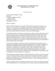
Figure 1: MBTA schedule <strong>in</strong>formation provided on i-Phone<br />
State-of-the-Art/Future<br />
State-of-the-art service alert systems allow travelers to customize the alerts they receive<br />
personally to be specific to routes, stops, <strong>and</strong> times. Customizable service alerts are<br />
available from a grow<strong>in</strong>g number of transit agencies <strong>and</strong> currently <strong>in</strong>clude Wash<strong>in</strong>gton<br />
Metropolitan Area Transit Authority, the Los Angeles County Metropolitan Transportation<br />
Authority, <strong>and</strong> the Massachusetts Bay Transportation Authority.<br />
Related Elements<br />
<strong>Information</strong> content: Station/stop, route, <strong>and</strong> schedule.<br />
<strong>Information</strong> format: Map, table, website, trip planner, <strong>and</strong> electronic message.<br />
<strong>Information</strong> delivery media: Signage, public announcement, telephone, human assistance,<br />
pr<strong>in</strong>ted material (for planned service alert), personal computer, mobile device, <strong>and</strong> kiosk.<br />
1.1.3 Real-Time Location<br />
Basic/State-of-the-Practice<br />
Although real-time location <strong>in</strong>formation has existed s<strong>in</strong>ce World War II via Long Range Aid<br />
to Navigation (LORAN), it was not until the advent of global position<strong>in</strong>g systems (GPS) <strong>in</strong> the<br />
early 1990s that real-time location became widely available to consumers for navigational<br />
purposes (LORAN, 2009; Global Position<strong>in</strong>g System, 2009). Today many travelers carry<br />
FTA OFFICE OF MOBILITY INNOVATION /<br />
U.S. DOT RITA VOLPE CENTER 14 MAY 2011
TRAVELER INFORMATION SYSTEMS AND WAYFINDING TECHNOLOGIES IN TRANSIT SYSTEMS<br />
mobile <strong>and</strong> wireless devices with embedded low-cost GPS functionality that provides the<br />
traveler’s absolute location <strong>and</strong> relative motion at any time. Automatic vehicle location<br />
systems commonly generate real-time location <strong>in</strong>formation for transit vehicles <strong>and</strong> enable<br />
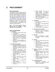
operators to track vehicle position. By merg<strong>in</strong>g real-time location of transit vehicles with<br />
traffic <strong>and</strong> congestion data, vendors (such as NextBus, Clever Devices, <strong>and</strong> TransLoc) are<br />
provid<strong>in</strong>g transit agencies <strong>and</strong> travelers with up-to-the-m<strong>in</strong>ute arrival times.<br />
Figure 2: NextBus mapp<strong>in</strong>g <strong>and</strong> route <strong>in</strong>formation for San Francisco Bay Area<br />
State-of-the-Art/Future<br />
Merg<strong>in</strong>g real-time locations with other types of spatial <strong>in</strong>formation, <strong>and</strong> shar<strong>in</strong>g these<br />
results with travelers, is driv<strong>in</strong>g advances <strong>in</strong> wayf<strong>in</strong>d<strong>in</strong>g (Schweiger, 2003). With these<br />
advances, travelers may f<strong>in</strong>e-tune their travel plans pre-trip <strong>and</strong> make more <strong>in</strong>formed<br />
decisions en route by acquir<strong>in</strong>g real-time <strong>in</strong>formation via trip planners, electronic messages,<br />
<strong>and</strong> mobile devices (as noted <strong>in</strong> the San Francisco example <strong>in</strong> Figure 2). Shar<strong>in</strong>g real-time<br />
<strong>in</strong>formation with travelers at all stages of their trips results <strong>in</strong> strong, positive net social<br />
benefits (Cham et al, 2003).<br />
The collection <strong>and</strong> public dissem<strong>in</strong>ation of real-time location data faces several challenges.<br />
Ma<strong>in</strong>ta<strong>in</strong><strong>in</strong>g data accuracy, ensur<strong>in</strong>g the system is flexible enough to cater to a transit<br />
operat<strong>in</strong>g environment where changes can occur unexpectedly, ma<strong>in</strong>ta<strong>in</strong><strong>in</strong>g timetable<br />
<strong>in</strong>formation, <strong>and</strong> automat<strong>in</strong>g detection of system failures are potential challenges<br />
(Schweiger, 2003). Factors hav<strong>in</strong>g the most <strong>in</strong>fluence on the accuracy of bus arrival<br />
estimates are: route type, time of day, <strong>and</strong> the next arrival estimate; whereas, research has<br />
demonstrated that factors such as vehicle load factor, schedule deviation, <strong>and</strong> operator<br />
FTA OFFICE OF MOBILITY INNOVATION /<br />
U.S. DOT RITA VOLPE CENTER 15 MAY 2011
TRAVELER INFORMATION SYSTEMS AND WAYFINDING TECHNOLOGIES IN TRANSIT SYSTEMS<br />
characteristics appear to have little or no <strong>in</strong>fluence on vehicle arrival estimation accuracy<br />
(Crout, 2007).<br />
Related Elements<br />
<strong>Information</strong> content: Station/stop, route, schedule, dest<strong>in</strong>ation/attraction, <strong>and</strong> vehicle load<br />
factor.<br />
<strong>Information</strong> format: Map, table, website, trip planner, <strong>and</strong> electronic message.<br />
<strong>Information</strong> delivery media: Signage, public announcement, telephone, personal<br />
computer, mobile device, <strong>and</strong> kiosk.<br />
1.1.4 Dest<strong>in</strong>ations<br />
Basic/State-of-the-Practice<br />
Nam<strong>in</strong>g stations <strong>and</strong> stops after streets <strong>and</strong> well-known l<strong>and</strong>marks can facilitate system<br />
usage <strong>and</strong> orient travelers with their surround<strong>in</strong>gs (TTI <strong>and</strong> NuStats, 1999). The Wash<strong>in</strong>gton<br />
Metropolitan Area Transit Authority <strong>in</strong>cludes icons represent<strong>in</strong>g the U.S. Capitol, the White<br />
House, the L<strong>in</strong>coln <strong>and</strong> Jefferson Memorials, <strong>and</strong> the Wash<strong>in</strong>gton Monument on its system<br />
map. On its website the Massachusetts Bay Transportation Authority has a list of accessible<br />
subway stops nearest popular dest<strong>in</strong>ations <strong>in</strong>clud<strong>in</strong>g Harvard <strong>and</strong> MIT, Fenway Park, Boston<br />
Common, <strong>and</strong> Faneuil Hall Marketplace (MBTA, 2006). The Dallas Area Rapid Transit also<br />
lists weekly events accessible by the transit system on its website (DART, 2009).<br />
FTA OFFICE OF MOBILITY INNOVATION /<br />
U.S. DOT RITA VOLPE CENTER 16 MAY 2011
TRAVELER INFORMATION SYSTEMS AND WAYFINDING TECHNOLOGIES IN TRANSIT SYSTEMS<br />
State-of-the-Art/Future<br />
Figure 3: London's Nearest Tube—iPhone 3G Application<br />
Third parties are lead<strong>in</strong>g the way <strong>in</strong> <strong>in</strong>tegrat<strong>in</strong>g transit <strong>in</strong>formation with a range of<br />
dest<strong>in</strong>ation types, such as restaurants or specific bus<strong>in</strong>esses. For example, Google Maps<br />
<strong>in</strong>tegrates locations of local bus<strong>in</strong>esses with data provided by transit agencies, such as<br />
station locations, rout<strong>in</strong>g, <strong>and</strong> schedul<strong>in</strong>g, as part of its Google Transit <strong>in</strong>itiative.<br />
A powerful development <strong>in</strong> layer<strong>in</strong>g transit <strong>and</strong> dest<strong>in</strong>ation data has been ”mashups” of<br />
maps <strong>and</strong> transit data with external data provided by third party <strong>and</strong> <strong>in</strong>dependent<br />
developers. Mashups are web applications that <strong>in</strong>tegrate data or functionality from one or<br />
more sources <strong>in</strong>to a s<strong>in</strong>gle application.<br />
An example of a mashup is One Bus Away, a tool focus<strong>in</strong>g on Seattle <strong>and</strong> surround<strong>in</strong>g K<strong>in</strong>g<br />
County. One Bus Away comb<strong>in</strong>es maps from Google Maps with stops, routes, <strong>and</strong> transit<br />
schedules, plus dest<strong>in</strong>ation <strong>in</strong>formation from Yelp.com (Ferris <strong>and</strong> Watk<strong>in</strong>s, 2009). By<br />
search<strong>in</strong>g for ‘pizza’ near the start location ‘3 rd <strong>and</strong> Pike’, the tool displays a color gradation<br />
map of all locations located with<strong>in</strong> one bus ride of the start location. The tool displays a list<br />
of restaurants <strong>and</strong> associated rat<strong>in</strong>gs from Yelp.com <strong>and</strong> travel times to all the pizza<br />
restaurants. The pizza restaurants are also mapped. Click<strong>in</strong>g on a restaurant gives the user<br />
the option to visit the Yelp.com page for detailed reviews or get detailed transit travel<br />
<strong>in</strong>structions. One Bus Away is the product of two graduate students at the University of<br />
Wash<strong>in</strong>gton.<br />
FTA OFFICE OF MOBILITY INNOVATION /<br />
U.S. DOT RITA VOLPE CENTER 17 MAY 2011
TRAVELER INFORMATION SYSTEMS AND WAYFINDING TECHNOLOGIES IN TRANSIT SYSTEMS<br />
Figure 4: Seattle's One Bus Away (OneBusAway.org)<br />
Other examples <strong>in</strong>clude an onl<strong>in</strong>e mailbox locator that maps location of public mailboxes<br />
with post offices on Google Maps <strong>and</strong> the location of major transit stations (Thomas, 2009),<br />
<strong>and</strong> an <strong>in</strong>teractive New York subway map (based on Google Maps) that displays detailed<br />
station maps that allow users to search for addresses <strong>and</strong> bus<strong>in</strong>esses (onNYTurf.com, 2009).<br />
It is reasonable to expect that future mashups of dest<strong>in</strong>ations <strong>and</strong> transit <strong>in</strong>formation will<br />
<strong>in</strong>clude service alerts <strong>and</strong> real-time vehicle location <strong>and</strong> schedule updates. In addition, GPSenabled<br />
mobile devices may one day alert carriers of nearby services or amenities as the<br />
transit vehicles approach specific dest<strong>in</strong>ations.<br />
Related Elements<br />
<strong>Information</strong> content: Station/stop, route, schedule, service alert <strong>and</strong> real-time location.<br />
<strong>Information</strong> format: Map, table, website, trip planner, <strong>and</strong> electronic message.<br />
<strong>Information</strong> delivery media: Personal computer, mobile device, <strong>and</strong> kiosk.<br />
1.1.5 Vehicle Passenger Load Factor<br />
Basic/State-of-the-Practice<br />
Vehicle load factor is the ratio of actual passengers to capacity. A load factor of 0 means a<br />
vehicle is empty, <strong>and</strong> a factor of 1 means a vehicle is at or above capacity. Most vehicle<br />
passenger counts are scheduled seasonal counts <strong>and</strong> are usually taken by route, not for any<br />
specific vehicle trip.<br />
Although it could be used to assist travelers <strong>in</strong> select<strong>in</strong>g less-crowded vehicles, load factor is<br />
neither collected nor shared with travelers as a st<strong>and</strong>ard practice. (Occasionally, past<br />
FTA OFFICE OF MOBILITY INNOVATION /<br />
U.S. DOT RITA VOLPE CENTER 18 MAY 2011
TRAVELER INFORMATION SYSTEMS AND WAYFINDING TECHNOLOGIES IN TRANSIT SYSTEMS<br />
vehicle passenger counts are made available <strong>in</strong> Annual Reports, plann<strong>in</strong>g documents, or<br />
project proposals.) This data is rarely systematically used, <strong>and</strong> most report<strong>in</strong>g of load factor<br />
is currently done by the vehicle operator to the dispatch office via radio. The Wash<strong>in</strong>gton<br />
Metropolitan Area Transit Authority is unusual <strong>in</strong> provid<strong>in</strong>g its users with expected tra<strong>in</strong><br />
capacity by broadcast<strong>in</strong>g the number of cars <strong>in</strong> each tra<strong>in</strong>, us<strong>in</strong>g its next tra<strong>in</strong> arrival system<br />
(WMATA, 2009a).<br />
State-of-the-Art/Future<br />
Riders of the Bay Area Rapid Transit system have expressed a strong desire to receive realtime<br />
load factor data along with real-time location <strong>in</strong>formation, so they can choose to avoid<br />
full vehicles (BART Market<strong>in</strong>g <strong>and</strong> Research Department, 2009). Automatic passenger<br />
counters (APCs) <strong>and</strong> electronic fare collection systems (EFCs) are expected to enable<br />
collection <strong>and</strong> dissem<strong>in</strong>ation of this <strong>in</strong>formation to users <strong>in</strong> the future. Currently, a few<br />
transit agencies have <strong>in</strong>tegrated AVL, APC <strong>and</strong> EFC systems for utiliz<strong>in</strong>g this <strong>in</strong>formation to<br />
enhance <strong>and</strong> support real-time dispatch<strong>in</strong>g functions, if so desired.<br />
Related Elements<br />
<strong>Information</strong> content: Station/stop, route, schedule, <strong>and</strong> real-time location.<br />
<strong>Information</strong> format: Map, table, website, trip planner, <strong>and</strong> electronic message.<br />
<strong>Information</strong> delivery media: Signage, public announcement, telephone, personal computer,<br />
<strong>and</strong> mobile device.<br />
1.2 Transit <strong>Information</strong> Format<br />
Various <strong>in</strong>formation formats—the ways <strong>in</strong> which <strong>in</strong>formation is presented—can be used to<br />
facilitate communication with transit users. This section describes the range of available<br />
formats.<br />
1.2.1 Maps<br />
Basic/State-of-the-Practice<br />
A map is a visual representation of an area. A transit map is a symbolic depiction<br />
highlight<strong>in</strong>g relationships between stations/stops, routes, dest<strong>in</strong>ations, <strong>and</strong> attractions.<br />
Traditionally, maps are pr<strong>in</strong>ted on paper <strong>and</strong> complemented or re<strong>in</strong>forced by stationary<br />
signs.<br />
In recent years, the Internet has made <strong>in</strong>teractive maps widely available. MapQuest <strong>and</strong><br />
Yahoo! Maps popularized highway maps <strong>and</strong> <strong>in</strong>teractive driv<strong>in</strong>g direction tools <strong>in</strong> the mid-<br />
FTA OFFICE OF MOBILITY INNOVATION /<br />
U.S. DOT RITA VOLPE CENTER 19 MAY 2011
TRAVELER INFORMATION SYSTEMS AND WAYFINDING TECHNOLOGIES IN TRANSIT SYSTEMS<br />
1990s, followed by Google Maps <strong>in</strong> 2005. Transit agencies have emulated these automobile<br />
trip plann<strong>in</strong>g services to create map-based trip planners for transit systems.<br />
State-of-the-Art/Future<br />
Figure 5: BART's system map on PDA display<br />
A significant advance is the accessibility of <strong>in</strong>teractive digital maps from personal computers<br />
<strong>and</strong> h<strong>and</strong>held mobile devices, <strong>in</strong>clud<strong>in</strong>g cell phones, personal digital assistants (PDAs), <strong>and</strong><br />
GPS navigation units. Electronic maps displayed on networked mobile devices are<br />
<strong>in</strong>creas<strong>in</strong>gly able to display, not only routes <strong>and</strong> places, but real-time location of the device<br />
itself <strong>and</strong> the location of transit vehicles (K<strong>in</strong>g County, 2009; CTA, 2009). Examples <strong>in</strong>clude:<br />
• As of May 2009, Google Transit displays station/stop, route, <strong>and</strong> schedule<br />
<strong>in</strong>formation for over 70 transit systems <strong>in</strong> 10 countries, us<strong>in</strong>g Google Maps<br />
technology (Google, 2009c). To participate, transit agencies must publish their<br />
transit <strong>in</strong>formation <strong>in</strong> the General Transit Feed Specification (GTFS) (Google, 2009b).<br />
The <strong>in</strong>formation is supplemented with Google Maps’ local search, satellite, street,<br />
terra<strong>in</strong>, <strong>and</strong> build<strong>in</strong>gs views, plus walk<strong>in</strong>g directions, <strong>and</strong> traffic.<br />
• OpenStreetMap is an effort to provide free geographic data such as street maps to<br />
anyone who wants them. Contributors may geocode <strong>and</strong> upload l<strong>and</strong>marks, routes,<br />
<strong>and</strong> other features as desired. Developers are encouraged to use these maps <strong>in</strong><br />
creative, productive, or unexpected ways (OpenStreetMap, 2009). Products of<br />
OpenStreetMap <strong>in</strong>clude a map of London’s Underground <strong>and</strong> <strong>in</strong>tercity buses <strong>in</strong><br />
Western Europe.<br />
• Houston Metro provides iPod-compatible bus route maps (METRO, 2008).<br />
FTA OFFICE OF MOBILITY INNOVATION /<br />
U.S. DOT RITA VOLPE CENTER 20 MAY 2011
TRAVELER INFORMATION SYSTEMS AND WAYFINDING TECHNOLOGIES IN TRANSIT SYSTEMS<br />
Figure 6: Houston MetroRail system map for iPod<br />
Related Elements<br />
<strong>Information</strong> content: Station/stop, route, service alert, real-time location, dest<strong>in</strong>ation, <strong>and</strong><br />
vehicle load factor.<br />
<strong>Information</strong> format: Website <strong>and</strong> trip planner.<br />
<strong>Information</strong> delivery media: Signage, pr<strong>in</strong>ted material, personal computer, mobile device,<br />
<strong>and</strong> kiosk.<br />
1.2.2 Tables<br />
Basic/State-of-the-Practice<br />
Non-<strong>in</strong>teractive tables have traditionally been used to display static schedule <strong>and</strong> fare<br />
<strong>in</strong>formation on pr<strong>in</strong>ted materials, signs, kiosks, <strong>and</strong> websites. Examples of static tables are<br />
found on brochures <strong>in</strong> transit stations <strong>and</strong> posted on signposts of most transit systems.<br />
State-of-the-Art/Future<br />
State-of-the-art tables are dynamic. Examples of dynamic tables <strong>in</strong>clude departure <strong>and</strong><br />
arrival tables at airports <strong>and</strong> tra<strong>in</strong> stations <strong>and</strong> service alert <strong>in</strong>formation published on web<br />
pages, such as those provided by the Massachusetts Bay Transportation Authority’s (MBTA,<br />
2009). Other examples <strong>in</strong>clude:<br />
• Wash<strong>in</strong>gton Metropolitan Area Transit Authority has employed the use of dynamic<br />
tra<strong>in</strong> arrival tables at stations s<strong>in</strong>ce 2000 (White, 2000).<br />
• Due to the screen-size constra<strong>in</strong>ts of mobile devices, tables <strong>and</strong> lists have been<br />
convenient <strong>and</strong> popular ways to display multiple route <strong>and</strong> vehicle <strong>in</strong>formation on<br />
devices. Examples <strong>in</strong>clude the Chicago Transit Authority’s Bus Tracker ‘arrival’ view<br />
(CTA, 2009), TriMet Tracker (TriMet Tracker, 2009), <strong>and</strong> iBART (iBART, 2009).<br />
FTA OFFICE OF MOBILITY INNOVATION /<br />
U.S. DOT RITA VOLPE CENTER 21 MAY 2011
Figure 7: iBart display<br />
Related Elements<br />
TRAVELER INFORMATION SYSTEMS AND WAYFINDING TECHNOLOGIES IN TRANSIT SYSTEMS<br />
<strong>Information</strong> content: Station/stop, route, schedule, fare, service alert, real-time location,<br />
dest<strong>in</strong>ation, <strong>and</strong> vehicle load factor.<br />
<strong>Information</strong> format: Text, website, trip planner, <strong>and</strong> electronic message.<br />
<strong>Information</strong> delivery media: Signage, pr<strong>in</strong>ted material, personal computer, mobile device,<br />
<strong>and</strong> kiosk.<br />
1.2.3 Text<br />
Basic/State-of-the-Practice<br />
Written text is a basic form of communication <strong>and</strong> is used throughout transit systems to<br />
describe virtually all types of <strong>in</strong>formation <strong>in</strong>clud<strong>in</strong>g directions, routes, stops, times, <strong>and</strong><br />
fares. Text may take the form of labels on a map, entries <strong>in</strong> a table, directions or notices on<br />
a sign, or descriptions of places, th<strong>in</strong>gs, or policies. Text is also required under the 1990<br />
Americans with Disabilities Act as an alternative message system to audio <strong>in</strong>formation.<br />
The effectiveness of text can be enhanced <strong>in</strong> several ways (TTI <strong>and</strong> NuStats, 1999).<br />
Typefaces that are sans-serif, for example, are easier to read at a distance by people with<br />
visual impairments, children, <strong>and</strong> those with limited education. Examples of these fonts<br />
<strong>in</strong>clude Helvetica <strong>and</strong> Gothic. Stroke width, character <strong>and</strong> l<strong>in</strong>e spac<strong>in</strong>g, <strong>and</strong> type size also<br />
affect readability, <strong>and</strong> appropriate guidel<strong>in</strong>es should be considered with respect to use,<br />
visual angle, colors, <strong>and</strong> contrast (TTI <strong>and</strong> NuStats, 1999; KRW, 1996).<br />
FTA OFFICE OF MOBILITY INNOVATION /<br />
U.S. DOT RITA VOLPE CENTER 22 MAY 2011
TRAVELER INFORMATION SYSTEMS AND WAYFINDING TECHNOLOGIES IN TRANSIT SYSTEMS<br />
State-of-the-Art/Future<br />
Delivery methods that convey text are advanc<strong>in</strong>g with the growth of dynamic message<br />
signs, text messages, email, <strong>and</strong> electronic maps available onl<strong>in</strong>e or on mobile devices.<br />
These text delivery methods are covered throughout this section.<br />
Related Elements<br />
<strong>Information</strong> content: Station/stop, route, schedule, fare, service alert, real-time location,<br />
dest<strong>in</strong>ation, <strong>and</strong> vehicle load factor.<br />
<strong>Information</strong> format: Map, table, website, trip planner, <strong>and</strong> electronic message.<br />
<strong>Information</strong> delivery media: Signage, pr<strong>in</strong>ted material, personal computer, mobile device,<br />
transit television, <strong>and</strong> kiosk.<br />
1.2.4 Audio<br />
Basic/State-of-the-Practice<br />
Enactment of the 1990 Americans with Disabilities Act has meant that audio <strong>in</strong>formation is<br />
a prom<strong>in</strong>ent alternative to visual <strong>in</strong>formation. 2<br />
The regulation requires that any audio<br />
equipment provided by a transit agency be ma<strong>in</strong>ta<strong>in</strong>ed <strong>in</strong> an operative condition (although<br />
the U.S. DOT’s regulations on implement<strong>in</strong>g the Act do not require the use of audio<br />
equipment). The requirement is that stop announcements be made <strong>in</strong> such a manner that<br />
they can be heard by every person rid<strong>in</strong>g the bus.<br />
Audio communication has historically been the prime method for transmitt<strong>in</strong>g en-route<br />
traveler <strong>in</strong>formation, especially <strong>in</strong>-vehicle <strong>and</strong> at major transfer po<strong>in</strong>ts. Today, audio<br />
systems, called annunciators, have taken on new forms, such as: electronic sign/audio<br />
annunciators at stops; <strong>in</strong>formation kiosks with audio capabilities at stops; or electronic<br />
sign/audio annunciators <strong>in</strong> vehicles. These systems provide both visual <strong>and</strong> audio<br />
2<br />
The U.S. DOT ADA regulations at 49 CFR sections 37.167(b) <strong>and</strong> (c) require that stop announcements must be<br />
made on fixed route systems as follows:<br />
(b) On fixed route systems, the entity shall announce stops as follows:<br />
1. The entity shall announce at least at transfer po<strong>in</strong>ts with other fixed routes, other<br />
major <strong>in</strong>tersections <strong>and</strong> dest<strong>in</strong>ation po<strong>in</strong>ts, <strong>and</strong> <strong>in</strong>tervals along a route sufficient to<br />
permit <strong>in</strong>dividuals with visual impairments or other disabilities to be oriented to<br />
their location.<br />
2. The entity shall announce any stop on request of an <strong>in</strong>dividual with a disability.<br />
(c) Where vehicles or other conveyances for more than one route serve the same stop, the<br />
entity shall provide a means by which an <strong>in</strong>dividual with a visual impairment or other disability<br />
can identify the proper vehicle to enter or be identified to the vehicle operator as a person<br />
seek<strong>in</strong>g a ride on a particular route.<br />
FTA OFFICE OF MOBILITY INNOVATION /<br />
U.S. DOT RITA VOLPE CENTER 23 MAY 2011
TRAVELER INFORMATION SYSTEMS AND WAYFINDING TECHNOLOGIES IN TRANSIT SYSTEMS<br />
announcements on board transit vehicles automatically. Announcements typically <strong>in</strong>clude<br />
next stop, transfer location, <strong>and</strong> vehicle route <strong>and</strong> dest<strong>in</strong>ation <strong>in</strong>formation.<br />
Figure 8: WMATA Metrobus “Talk<strong>in</strong>g Sign”<br />
Automatic annunciators relieve transit vehicle drivers of verbally mak<strong>in</strong>g next stop <strong>and</strong><br />
transfer location announcements for passengers. While the audible system ensures that<br />
persons with visual <strong>and</strong> hear<strong>in</strong>g limitations obta<strong>in</strong> important stop <strong>and</strong> route-specific<br />
<strong>in</strong>formation, it also helps anyone unfamiliar with the transit system to identify the proper<br />
transit vehicle (route <strong>and</strong> direction) when board<strong>in</strong>g a vehicle, <strong>and</strong> the proper stop location<br />
when exit<strong>in</strong>g the vehicle.<br />
Pre-trip audio traveler <strong>in</strong>formation is also commonly provided via customer service centers.<br />
Specialized read<strong>in</strong>g software enables transit agencies’ websites to be translated for<br />
<strong>in</strong>dividuals who are sight impaired. However, the software is primarily privately-used <strong>and</strong><br />
the transit websites must be Section 508 compliant <strong>in</strong> most cases to obta<strong>in</strong> the greatest use<br />
of the read<strong>in</strong>g software.<br />
State-of-the-Art/Future<br />
Transit environments are typically very noisy (cavernous stations, urban noise, <strong>in</strong>ternal <strong>and</strong><br />
external vehicle noise, etc.) <strong>and</strong> not conducive to extensive reliance on audio <strong>in</strong>formation.<br />
In addition, the quality of the public address or <strong>in</strong>tercom systems <strong>in</strong> any public location has<br />
largely been poor. With improved acoustical technologies, the quality of audio systems is<br />
improv<strong>in</strong>g over the historically muffled sound systems.<br />
A test of Remote Infrared Audible Signage (RIAS) conducted <strong>in</strong> Seattle demonstrated that<br />
the system could eventually enable bl<strong>in</strong>d or visually impaired users to “hear” real-time <strong>and</strong><br />
FTA OFFICE OF MOBILITY INNOVATION /<br />
U.S. DOT RITA VOLPE CENTER 24 MAY 2011
TRAVELER INFORMATION SYSTEMS AND WAYFINDING TECHNOLOGIES IN TRANSIT SYSTEMS<br />
static wayf<strong>in</strong>d<strong>in</strong>g transit <strong>in</strong>formation signage. Personal mobile devices are enabl<strong>in</strong>g<br />
travelers to obta<strong>in</strong> more real-time audio <strong>in</strong>formation on dem<strong>and</strong>. In the future,<br />
personalized audible traveler directions utiliz<strong>in</strong>g mobile devices’ GPS capabilities could be<br />
possible.<br />
Figure 9: RAIS Personal Mobile Device be<strong>in</strong>g tested <strong>in</strong> Seattle<br />
Related Elements<br />
<strong>Information</strong> content: Station/stop, route, schedule, fare, service alert, real-time location,<br />
dest<strong>in</strong>ation, <strong>and</strong> vehicle load factor.<br />
<strong>Information</strong> format: Map, website, trip planner, <strong>and</strong> electronic message.<br />
<strong>Information</strong> delivery media: Signage with annunciators, personal computer, mobile device,<br />
transit television, <strong>and</strong> kiosk.<br />
1.2.5 Websites<br />
Basic/State-of-the-Practice<br />
<strong>Information</strong> available at transit websites ranges from basic service <strong>in</strong>formation on fares,<br />
schedules, <strong>and</strong> routes, to procurement notices, job post<strong>in</strong>gs, board m<strong>in</strong>utes, <strong>and</strong> plann<strong>in</strong>g<br />
activities. As of 2009, an estimated 223 million Americans, or roughly 73 percent (73%) of<br />
the population, have access to the Internet (Wolfram Alpha, 2009a). The Internet presents<br />
transit <strong>in</strong>formation to exist<strong>in</strong>g <strong>and</strong> potential public transit users <strong>in</strong> a cost-effective way<br />
(Kenyon et al, 2001). Transit agency <strong>in</strong>formation technology staff report that Internet users<br />
are <strong>in</strong>terested <strong>in</strong> basic customer <strong>in</strong>formation to help them plan trips <strong>and</strong> current<br />
<strong>in</strong>formation on construction diversions <strong>and</strong> unplanned <strong>in</strong>cidents.<br />
Transit website managers have used <strong>and</strong> cont<strong>in</strong>ue to use a process of experimentation,<br />
customer feedback, <strong>and</strong> periodic redesign to develop their sites <strong>in</strong>to tools for bus, rail, <strong>and</strong><br />
paratransit customers to plan trips, <strong>and</strong> to access a variety of <strong>in</strong>formation (Schaller, 2002).<br />
The most important contributor to users’ perceptions regard<strong>in</strong>g onl<strong>in</strong>e quality of service of<br />
transit websites is efficiency, def<strong>in</strong>ed as ease <strong>and</strong> speed of access<strong>in</strong>g desired <strong>in</strong>formation<br />
(Eriksson et al, 2007).<br />
FTA OFFICE OF MOBILITY INNOVATION /<br />
U.S. DOT RITA VOLPE CENTER 25 MAY 2011
TRAVELER INFORMATION SYSTEMS AND WAYFINDING TECHNOLOGIES IN TRANSIT SYSTEMS<br />
Importantly, web pages should be designed to provide <strong>in</strong>formation to all possible users.<br />
Section 508 of the Rehabilitation Act of 1973, (amended <strong>in</strong> 1998 <strong>and</strong> codified <strong>in</strong> 29 USC §<br />
794d) requires electronic technology used by the federal government to be accessible to<br />
persons with disabilities. Five types of disabilities can affect Internet usage: visual, hear<strong>in</strong>g,<br />
mobility, cognitive impairments, <strong>and</strong> seizure disorders. Examples of Section 508 st<strong>and</strong>ards<br />
that apply to websites <strong>and</strong> electronic documents <strong>in</strong>clude the follow<strong>in</strong>g actions:<br />
• Provid<strong>in</strong>g a text equivalent for every non-text element;<br />
• Assur<strong>in</strong>g all <strong>in</strong>formation conveyed with color is available without color;<br />
• Provid<strong>in</strong>g row <strong>and</strong> column headers <strong>in</strong> all data tables; <strong>and</strong><br />
• Prevent<strong>in</strong>g the screen from flicker<strong>in</strong>g with a frequency greater than 2 Hz <strong>and</strong> lower<br />
than 55 Hz (Schaller, 2002). 3<br />
The st<strong>and</strong>ards apply to federal web sites but not to private sector websites (unless a site is<br />
provided under contract to a federal agency, <strong>in</strong> which case only that website or the portion<br />
covered by the contract would have to comply). Most transit agencies express a desire to<br />
provide accessibility of their website <strong>in</strong>formation to people with disabilities, although there<br />
has been some uncerta<strong>in</strong>ty as to whether transit agencies are required to under federal law<br />
(Schaller, 2002). A number of states do require all publicly-f<strong>in</strong>anced websites to comply<br />
with Section 508 or state-developed access st<strong>and</strong>ards.<br />
In addition to agency-specific websites, many transit agencies have begun to use social<br />
network<strong>in</strong>g sites as a means to quickly dissem<strong>in</strong>ate transit traveler <strong>in</strong>formation. Bay Area<br />
Rapid Transit, Wash<strong>in</strong>gton Metropolitan Area Transit Authority, K<strong>in</strong>g County Metro <strong>and</strong> a<br />
grow<strong>in</strong>g number of other transit agencies are us<strong>in</strong>g third party website services like email or<br />
text message, social group<strong>in</strong>g, <strong>and</strong> video feeds to provide transit service alerts, special<br />
event <strong>in</strong>formation, or <strong>in</strong>struction on how to use the transit system. Social network<strong>in</strong>g sites<br />
are often favored for the ability to make timely updates to data, <strong>and</strong> for the cost sav<strong>in</strong>gs on<br />
market<strong>in</strong>g <strong>and</strong> website ma<strong>in</strong>tenance. These sites are recognized as important tools that<br />
transit agencies may use to <strong>in</strong>crease customer communications, as opposed to<br />
replacements for traditional methods of communication (Metro Magaz<strong>in</strong>e, 2009).<br />
State-of-the-Art/Future<br />
State-of-the-art transit websites are common among medium <strong>and</strong> large agencies with large<br />
budgets <strong>and</strong> technical capability. Such websites are characterized by frequently updated<br />
news <strong>and</strong> service <strong>in</strong>formation, options to share service alerts via electronic messages <strong>and</strong><br />
feeds, <strong>and</strong> onl<strong>in</strong>e trip planners. Examples <strong>in</strong>clude:<br />
3 See: www.section508.gov.<br />
FTA OFFICE OF MOBILITY INNOVATION /<br />
U.S. DOT RITA VOLPE CENTER 26 MAY 2011
TRAVELER INFORMATION SYSTEMS AND WAYFINDING TECHNOLOGIES IN TRANSIT SYSTEMS<br />
• Some agencies, <strong>in</strong>clud<strong>in</strong>g Utah Transit Authority, Metropolitan Tulsa Transit<br />
Authority, New Jersey Transit, <strong>and</strong> Bay Area Rapid Transit have mobile websites<br />
specifically designed to be viewed on mobile devices. These sites are designed to be<br />
simple so that they load quickly over cellular data networks.<br />
• Wash<strong>in</strong>gton Metropolitan Area Transit Authority, Tri-County Metropolitan<br />
Transportation District of Oregon, Bay Area Rapid Transit, <strong>and</strong> Miami-Dade Transit’s<br />
Metrorail publish real-time vehicle arrivals on their websites.<br />
• Chicago Transit Authority, K<strong>in</strong>g County Metro, <strong>and</strong> Sioux City Transit System display<br />
maps of real-time vehicle locations on their websites.<br />
• Bay Area Rapid Transit also uses its website to advertise third party applications that<br />
utilize BART data to help riders make <strong>in</strong>formed travel decisions (BART, 2009b).<br />
Related Elements<br />
<strong>Information</strong> content: Station/stop, route, schedule, service alert, real-time location,<br />
dest<strong>in</strong>ation, <strong>and</strong> vehicle load factor.<br />
<strong>Information</strong> format: Map, table, trip planner, <strong>and</strong> electronic message.<br />
<strong>Information</strong> delivery media: Personal computer, mobile device, <strong>and</strong> kiosk.<br />
1.2.6 Trip Planner<br />
Basic/State-of-the-Practice<br />
Trip planners, also known as journey planners, are specialized electronic search eng<strong>in</strong>es that<br />
f<strong>in</strong>d the best journey between two po<strong>in</strong>ts by some means of transport (Journey planner,<br />
2009). The first popular onl<strong>in</strong>e trip planner, Mapquest, was released <strong>in</strong> 1996, <strong>and</strong> a popular<br />
trip planner from Yahoo! followed. These planners were focused on generat<strong>in</strong>g automobile<br />
driv<strong>in</strong>g directions <strong>and</strong> were closely <strong>in</strong>tegrated with maps. Google Maps began provid<strong>in</strong>g<br />
maps <strong>and</strong> trip plann<strong>in</strong>g functionality <strong>in</strong> 2005. S<strong>in</strong>ce then, Google Maps partnered with<br />
other firms to <strong>in</strong>tegrate directions <strong>and</strong> travel times for walk<strong>in</strong>g <strong>and</strong> public transit.<br />
Many transit agencies now offer onl<strong>in</strong>e trip planners for their systems (Rad<strong>in</strong> et al, 2002).<br />
The transit trip planner applications prompt users to <strong>in</strong>put orig<strong>in</strong>s <strong>and</strong> dest<strong>in</strong>ations to<br />
generate routes between po<strong>in</strong>ts us<strong>in</strong>g available transit services. Transit planners for large<br />
agencies <strong>in</strong>clud<strong>in</strong>g the Wash<strong>in</strong>gton Metropolitan Area Transit Authority, Bay Area Rapid<br />
Transit, Los Angeles County Metropolitan Transportation Authority, <strong>and</strong> the Massachusetts<br />
Bay Transportation Authority were <strong>in</strong>troduced <strong>in</strong> the early to mid-2000s. These tools began<br />
largely as s<strong>in</strong>gle-mode, s<strong>in</strong>gle-agency applications <strong>and</strong> have grown to <strong>in</strong>corporate multiple<br />
modes for s<strong>in</strong>gle trips. Over time, transit trip planners have been implemented <strong>in</strong> smaller<br />
markets. Aust<strong>in</strong>’s Capital Metro Transit, the Duluth Transit Authority, <strong>and</strong> the Greater<br />
FTA OFFICE OF MOBILITY INNOVATION /<br />
U.S. DOT RITA VOLPE CENTER 27 MAY 2011
TRAVELER INFORMATION SYSTEMS AND WAYFINDING TECHNOLOGIES IN TRANSIT SYSTEMS<br />
Clevel<strong>and</strong> Regional Transit Authority are examples of mid-sized agencies with onl<strong>in</strong>e transit<br />
trip planners.<br />
Figure 10: Tri-Met's Interactive System Map<br />
Transit trip planners have also been developed for persons with physical <strong>and</strong> cognitive<br />
disabilities. A project at the University of South Florida’s Center for Urban Transportation<br />
Research has developed a website to create <strong>and</strong> manage trip it<strong>in</strong>eraries for persons with<br />
disabilities by their travel tra<strong>in</strong>er <strong>and</strong>/or parent. The traveler carries a GPS-enabled mobile<br />
phone that signals when to get off the bus. The site allows the real-time track<strong>in</strong>g of the<br />
traveler <strong>and</strong> signals an alarm when the rider deviates from the planned route (Barbeau,<br />
2009).<br />
FTA OFFICE OF MOBILITY INNOVATION /<br />
U.S. DOT RITA VOLPE CENTER 28 MAY 2011
TRAVELER INFORMATION SYSTEMS AND WAYFINDING TECHNOLOGIES IN TRANSIT SYSTEMS<br />
State-of-the-Art/Future<br />
Advanced trip planners for public transit have <strong>in</strong>corporated plann<strong>in</strong>g for multiple modes<br />
<strong>and</strong> for service among multiple agencies.<br />
• Western European countries lead development of countrywide, door-to-door, public<br />
transportation trip planners. Examples <strong>in</strong>clude Transport For London (United<br />
K<strong>in</strong>gdom), Journey.fi (F<strong>in</strong>l<strong>and</strong>), OV9292 (The Netherl<strong>and</strong>s), <strong>and</strong> ResRobot (Sweden).<br />
These trip planners generate trips for walk<strong>in</strong>g, bik<strong>in</strong>g, driv<strong>in</strong>g, <strong>and</strong> public transit.<br />
•<br />
Figure 11: United K<strong>in</strong>gdom's JourneyOn travel<br />
it<strong>in</strong>erary website<br />
JourneyOn, a transportation website provided by the Brighton <strong>and</strong> Hove City Council <strong>in</strong><br />
the United K<strong>in</strong>gdom, generates travel it<strong>in</strong>eraries of the modes mentioned above <strong>and</strong><br />
provides distance, duration, calories expended, cost, <strong>and</strong> the carbon footpr<strong>in</strong>t for<br />
each. For walk<strong>in</strong>g <strong>and</strong> bik<strong>in</strong>g it<strong>in</strong>eraries, it allows users to choose to generate either<br />
the flattest or shortest routes (JourneyOn, 2009).<br />
• A-Tra<strong>in</strong>, a trip planner for Atlanta, allows users to generate routes us<strong>in</strong>g different<br />
options: walk only, bike only, walk to transit, <strong>and</strong> bike to transit (A-Tra<strong>in</strong>, 2007).<br />
• Fort Worth Transportation Authority has a web-based trip planner for its paratransit<br />
service.<br />
Interfaces for transit trip planners are <strong>in</strong> development for use on mobile device websites.<br />
Bay Area Rapid Transit, Wash<strong>in</strong>gton Metropolitan Area Transit Authority, <strong>and</strong> Chicago<br />
Transit Authority have mobile websites with simpler <strong>in</strong>terfaces relative to their systems’<br />
respective transit trip planners available on their home website.<br />
Advances <strong>in</strong> AVL systems <strong>and</strong> real-time location data collection analysis will improve trip<br />
plann<strong>in</strong>g applications <strong>in</strong> the future. Introduction of real-time location data from vehicles<br />
will improve accuracy of arrival, departure, <strong>and</strong> travel time estimates. And for users with<br />
GPS-enabled mobile devices, real-time data will improve estimated walk<strong>in</strong>g travel times.<br />
FTA OFFICE OF MOBILITY INNOVATION /<br />
U.S. DOT RITA VOLPE CENTER 29 MAY 2011
Related Elements<br />
TRAVELER INFORMATION SYSTEMS AND WAYFINDING TECHNOLOGIES IN TRANSIT SYSTEMS<br />
<strong>Information</strong> content: Station/stop, route, schedules, service alert, real-time location,<br />
dest<strong>in</strong>ation, <strong>and</strong> vehicle load factor.<br />
<strong>Information</strong> format: Map, table, <strong>and</strong> website.<br />
<strong>Information</strong> delivery media: Telephone, personal computer, mobile device, <strong>and</strong> kiosk.<br />
1.2.7 Electronic Messages<br />
Basic/State-of-the-Practice<br />
Electronic messages are used by transit agencies to communicate delays, outages, detours,<br />
<strong>and</strong> other ad-hoc, event-based <strong>in</strong>formation. Dynamic message signage (DMS) is the oldest<br />
<strong>and</strong> most basic real-time electronic message format delivered to groups of travelers at fixed<br />
locations. Direct electronic messages can now be targeted to specific users over<br />
telecommunications networks. Direct electronic messages are ‘opt-<strong>in</strong>’ systems with which<br />
users must register <strong>and</strong> confirm they wish to receive. Electronic messages usually take the<br />
form of either email, SMS, or RSS.<br />
Email has been a method of communicat<strong>in</strong>g electronically for the last 50 years, though it<br />
ga<strong>in</strong>ed ma<strong>in</strong>stream popularity <strong>in</strong> the 1990s along with the Internet. Modern email systems<br />
consist of computer server systems that accept, forward, or store messages on behalf of<br />
users, who only connect to the email <strong>in</strong>frastructure via personal computer or other<br />
network-enabled device for the duration of message transmission or retrieval. Transit<br />
agencies <strong>in</strong>clud<strong>in</strong>g New York City’s Metropolitan Transportation Authority, Chicago Transit<br />
Authority, Wash<strong>in</strong>gton Metropolitan Area Transit Authority, <strong>and</strong> Metro Transit <strong>in</strong> Madison,<br />
Wiscons<strong>in</strong> regularly use email to send alerts. The Wash<strong>in</strong>gton Metropolitan Area Transit<br />
Authority provides email alerts customizable by time of day <strong>and</strong> route for Metrorail, as well<br />
as provid<strong>in</strong>g separate alerts for persons with disabilities related to access issues <strong>and</strong><br />
elevator outages.<br />
SMS is a communication service that allows <strong>in</strong>terchange of short text messages between<br />
mobile telephone devices. SMS is used by transit agencies to communicate to travelers<br />
mobile devices via text messages. Bay Area Rapid Transit, Tri-County Metropolitan<br />
Transportation District of Oregon, <strong>and</strong> Massachusetts Bay Transportation Authority all use<br />
SMS systems.<br />
An RSS feed is an Internet method for deliver<strong>in</strong>g <strong>in</strong>formation, such as news stories (or<br />
snippets of them). <strong>Traveler</strong>s can take advantage of RSS feeds by subscrib<strong>in</strong>g to them us<strong>in</strong>g<br />
modern web browsers, email programs, RSS/news aggregators, <strong>and</strong> customizable start<br />
pages offered by major Internet services. Agencies that offer news <strong>and</strong> service alerts via<br />
FTA OFFICE OF MOBILITY INNOVATION /<br />
U.S. DOT RITA VOLPE CENTER 30 MAY 2011
TRAVELER INFORMATION SYSTEMS AND WAYFINDING TECHNOLOGIES IN TRANSIT SYSTEMS<br />
RSS feeds <strong>in</strong>clude Chicago Transit Authority, Duluth Transit Authority, Wash<strong>in</strong>gton<br />
Metropolitan Area Transit Agency, New York City’s Metropolitan Transit Agency, <strong>and</strong> New<br />
Jersey Transit.<br />
FTA OFFICE OF MOBILITY INNOVATION /<br />
U.S. DOT RITA VOLPE CENTER 31 MAY 2011
TRAVELER INFORMATION SYSTEMS AND WAYFINDING TECHNOLOGIES IN TRANSIT SYSTEMS<br />
State-of-the-Art/Future<br />
Some transit agencies recognize the need to improve the technology used to deliver mass<br />
amounts of electronic messages <strong>in</strong> short periods of time. Examples <strong>in</strong>clude:<br />
• In an assessment of New York City’s Metropolitan Transit Agency’s performance <strong>and</strong><br />
vulnerability follow<strong>in</strong>g severe regional flood<strong>in</strong>g <strong>in</strong> August 2007, the agency<br />
recommended f<strong>in</strong>d<strong>in</strong>g a communications provider capable of h<strong>and</strong>l<strong>in</strong>g as many as<br />
800,000 real-time email <strong>and</strong> text message alerts simultaneously (S<strong>and</strong>er, 2007).<br />
• SMS communications are beg<strong>in</strong>n<strong>in</strong>g to be used by travelers as an <strong>in</strong>teractive<br />
wayf<strong>in</strong>d<strong>in</strong>g tool rather than a passive receiv<strong>in</strong>g tool. For several transit systems<br />
<strong>in</strong>clud<strong>in</strong>g Suffolk County, United K<strong>in</strong>gdom, K<strong>in</strong>g County Metro, <strong>and</strong> Port Authority of<br />
Allegheny County, travelers may text unique numeric codes that represent routes or<br />
bus stops <strong>and</strong> receive <strong>in</strong>formation regard<strong>in</strong>g anticipated arrivals. Unique codes may<br />
be found on signs at bus stops. Vendors that provide this service <strong>in</strong>clude<br />
RouteShout, Dadnab, <strong>and</strong> Nextbus.<br />
Related Elements<br />
Figure 12: Dabnab offers one example of a transit stop text messag<strong>in</strong>g service<br />
<strong>Information</strong> content: Station/stop, route, schedule, service alert, real-time location, <strong>and</strong><br />
vehicle load factor.<br />
<strong>Information</strong> format: Text.<br />
<strong>Information</strong> delivery media: Signage, personal computer, <strong>and</strong> mobile device.<br />
FTA OFFICE OF MOBILITY INNOVATION /<br />
U.S. DOT RITA VOLPE CENTER 32 MAY 2011
TRAVELER INFORMATION SYSTEMS AND WAYFINDING TECHNOLOGIES IN TRANSIT SYSTEMS<br />
1.3 Transit <strong>Information</strong> Delivery Media<br />
Transit providers can convey <strong>in</strong>formation to customers through a variety of means. The<br />
follow<strong>in</strong>g section describes the media or devices used to provide transit <strong>in</strong>formation.<br />
1.3.1 Natural <strong>and</strong> Built Environment<br />
Basic/State-of-the-Practice<br />
In many ways, architectural design is used to deliver traveler <strong>in</strong>formation. Urban design<br />
traditionally focuses on the function of public space, the design of build<strong>in</strong>gs <strong>and</strong> the<br />
arrangement of transportation systems, retail space, <strong>and</strong> other amenities. Urban planners<br />
<strong>and</strong> architects consider the use of spaces that are used commonly by the general public,<br />
<strong>in</strong>clud<strong>in</strong>g streets, plazas, parks <strong>and</strong> public <strong>in</strong>frastructure. Physical elements that orient<br />
people <strong>and</strong> aid <strong>in</strong> wayf<strong>in</strong>d<strong>in</strong>g <strong>in</strong>clude paths, l<strong>and</strong>marks, nodes (entries <strong>and</strong> exits), edges<br />
(barriers), <strong>and</strong> districts (Lynch, 1960; Pass<strong>in</strong>i, 1984). These elements enable the three-stage<br />
wayf<strong>in</strong>d<strong>in</strong>g process: identify<strong>in</strong>g l<strong>and</strong>marks at orig<strong>in</strong> <strong>and</strong> dest<strong>in</strong>ation po<strong>in</strong>ts, develop<strong>in</strong>g<br />
orig<strong>in</strong> to dest<strong>in</strong>ation route knowledge, <strong>and</strong> develop<strong>in</strong>g survey knowledge <strong>in</strong>clud<strong>in</strong>g<br />
l<strong>and</strong>marks, routes, <strong>and</strong> approximate travel costs between orig<strong>in</strong>s <strong>and</strong> dest<strong>in</strong>ations (TTI <strong>and</strong><br />
NuStats, 1999).<br />
Paths at the city-scale are perceived as horizontal channels of movement such as streets<br />
<strong>and</strong> transit fixed routes. Inside build<strong>in</strong>gs, paths <strong>in</strong>clude hallways, stairs, escalators <strong>and</strong><br />
elevators, <strong>and</strong> elements of horizontal <strong>and</strong> vertical circulation systems.<br />
L<strong>and</strong>marks are dist<strong>in</strong>ct po<strong>in</strong>ts of reference <strong>in</strong>clud<strong>in</strong>g, at the city scale, parks, mounta<strong>in</strong>s,<br />
build<strong>in</strong>gs, or bridges. In an <strong>in</strong>door sett<strong>in</strong>g, a l<strong>and</strong>mark is recognized as a clearly prom<strong>in</strong>ent<br />
element that is localized <strong>in</strong> space. Sculptures <strong>and</strong> l<strong>and</strong>scap<strong>in</strong>g elements are examples of<br />
l<strong>and</strong>marks <strong>in</strong> built environments. Spaces that are dist<strong>in</strong>ct <strong>in</strong> character compared to other<br />
spaces may be perceived as l<strong>and</strong>marks <strong>and</strong> used by travelers to orient themselves. Arts <strong>in</strong><br />
Transit programs provide additional visual l<strong>and</strong>marks to help travelers identify stops,<br />
stations, or locations with<strong>in</strong> large stations.<br />
Nodes are the strategic spots of entry <strong>in</strong>to a city or focal po<strong>in</strong>ts of alignment dur<strong>in</strong>g travel.<br />
The equivalent po<strong>in</strong>ts <strong>in</strong> build<strong>in</strong>gs <strong>in</strong>clude lobbies, other large open spaces, such as a transit<br />
term<strong>in</strong>al <strong>in</strong>terior, <strong>and</strong> hallway <strong>in</strong>tersections.<br />
Edges are formed by boundaries or barriers that usually comprise l<strong>in</strong>ear elements, which<br />
cannot be used as paths. Rivers <strong>in</strong> cities <strong>and</strong> walls of build<strong>in</strong>gs, particularly the exterior<br />
walls, are examples of edges. In transit, the term<strong>in</strong>us po<strong>in</strong>t of each route can be seen as<br />
one of the transit system’s edges.<br />
FTA OFFICE OF MOBILITY INNOVATION /<br />
U.S. DOT RITA VOLPE CENTER 33 MAY 2011
TRAVELER INFORMATION SYSTEMS AND WAYFINDING TECHNOLOGIES IN TRANSIT SYSTEMS<br />
Districts are described as medium to large sections of space hav<strong>in</strong>g some common<br />
identify<strong>in</strong>g character, especially <strong>in</strong> terms of function. In cities, residential or commercial<br />
spaces can be called districts. In build<strong>in</strong>gs, floors <strong>and</strong> w<strong>in</strong>gs usually have a common<br />
functional character <strong>and</strong> can thus be deemed as districts. Transit systems can have dist<strong>in</strong>ct<br />
fare districts or transfer po<strong>in</strong>ts that segregate service <strong>in</strong>to de facto districts.<br />
State-of-the-Art/Future<br />
New methods of spatial analysis <strong>and</strong> cognitive mapp<strong>in</strong>g may provide opportunities to design<br />
improved public spaces by measur<strong>in</strong>g the properties of spatial layouts that users perceive:<br />
l<strong>in</strong>es of sight along streets <strong>and</strong> corridors, visual fields from public spaces, <strong>and</strong> degrees of<br />
privacy <strong>and</strong> openness (Space Syntax, 2009).<br />
• Space Syntax methods have been used by City of Oakl<strong>and</strong> <strong>and</strong> Southern California<br />
Association of Governments (SCAG), the MPO <strong>in</strong> the Los Angeles Metropolitan Area,<br />
to analyze the locations of pedestrian-oriented l<strong>and</strong> uses, bicycle <strong>and</strong> multi-modal<br />
transportation nodes, <strong>and</strong> bicycle <strong>and</strong> pedestrian routes. These agencies have used<br />
this <strong>in</strong>formation to determ<strong>in</strong>e where to allocate funds for improvements of visual<br />
identification of area, its use <strong>and</strong> modal l<strong>in</strong>kages with<strong>in</strong> an area (FHWA, 2009).<br />
• Space Syntax methods have also been used <strong>in</strong> quantitative studies of movement <strong>and</strong><br />
<strong>in</strong>gress/egress from London Underground stations (Chiaradai et al, 2005).<br />
Related Elements<br />
<strong>Information</strong> content: Station/ stop, route, <strong>and</strong> dest<strong>in</strong>ation.<br />
<strong>Information</strong> format: Physical design.<br />
<strong>Information</strong> delivery media: Physical design.<br />
1.3.2 Human Assistance<br />
Basic/State-of-the-Practice<br />
Transit operators, station agents, <strong>and</strong> customer service representatives play an important<br />
role <strong>in</strong> provid<strong>in</strong>g transit <strong>in</strong>formation to customers. Travel tra<strong>in</strong><strong>in</strong>g programs are one area<br />
where human assistance is paramount. Travel tra<strong>in</strong><strong>in</strong>g programs provide <strong>in</strong>struction to<br />
<strong>in</strong>dividuals who want to learn to travel <strong>in</strong>dependently us<strong>in</strong>g a fixed route transit system.<br />
Travel tra<strong>in</strong><strong>in</strong>g participants, <strong>in</strong>clud<strong>in</strong>g those with disabilities or seniors, learn the skills<br />
necessary for <strong>in</strong>dependent transit rid<strong>in</strong>g, such as how to plan a trip, navigate to the correct<br />
transit stop/station, <strong>and</strong> how to board <strong>and</strong> disembark the vehicle.<br />
Vehicle operators are another important conduit for communicat<strong>in</strong>g en-route wayf<strong>in</strong>d<strong>in</strong>g<br />
<strong>in</strong>formation. The 1990 Americans with Disabilities Act requires announcement of stops at<br />
FTA OFFICE OF MOBILITY INNOVATION /<br />
U.S. DOT RITA VOLPE CENTER 34 MAY 2011
TRAVELER INFORMATION SYSTEMS AND WAYFINDING TECHNOLOGIES IN TRANSIT SYSTEMS<br />
major <strong>in</strong>tersections, transfer po<strong>in</strong>ts <strong>and</strong> specific dest<strong>in</strong>ation po<strong>in</strong>ts. For systems that do not<br />
have automatic stop announcements, vehicle operators provide this service.<br />
State-of-the-Art/Future<br />
Partner<strong>in</strong>g transit travel <strong>in</strong>struction with other technological advances that simplify the use<br />
of public transit will facilitate the <strong>in</strong>creased <strong>in</strong>tegration <strong>and</strong> <strong>in</strong>clusion of persons with<br />
mobility difficulties <strong>in</strong>to ma<strong>in</strong>stream transit (Dorey, 2007).<br />
• Researchers at the Center for Urban Transportation Research have developed a<br />
prototype software system that can be <strong>in</strong>stalled <strong>in</strong> off-the-shelf GPS-enabled cell<br />
phones. The software delivers prompts, such as “get ready” <strong>and</strong> “pull the cord<br />
now.” Use of the tool as part of the travel tra<strong>in</strong><strong>in</strong>g curriculum further enhances<br />
transit rider <strong>in</strong>dependence <strong>and</strong> safety (NCTR, 2008).<br />
Related Elements<br />
<strong>Information</strong> content: Station/stop, route, schedule, fare, service alert, <strong>and</strong> dest<strong>in</strong>ation.<br />
<strong>Information</strong> format: Live or recorded voice.<br />
<strong>Information</strong> delivery media: Call center, <strong>and</strong> live or recorded voice message.<br />
1.3.3 Pr<strong>in</strong>ted Material<br />
Basic/State-of-the-Practice<br />
Pr<strong>in</strong>t materials are durable, portable, <strong>and</strong> highly accessible to nearly any type of traveler, at<br />
all travel stages. Traditional pr<strong>in</strong>t materials <strong>in</strong>clude: 1) a system map that shows the<br />
alignment of an agency’s transit routes; 2) a route map that shows the alignment of an<br />
<strong>in</strong>dividual transit route; <strong>and</strong> 3) the schedule or timetable that provides the tim<strong>in</strong>g<br />
<strong>in</strong>formation for an <strong>in</strong>dividual route. Federal Accessibility Guidel<strong>in</strong>es require transit agencies<br />
to provide pr<strong>in</strong>t materials <strong>in</strong> a format that accommodates people with disabilities. Such<br />
formats <strong>in</strong>clude large pr<strong>in</strong>t (at least 16 po<strong>in</strong>t font), tactile maps, color cod<strong>in</strong>g, <strong>and</strong> Braille.<br />
While pr<strong>in</strong>t material is a st<strong>and</strong>ard element of transit agency wayf<strong>in</strong>d<strong>in</strong>g assistance, many<br />
people f<strong>in</strong>d pr<strong>in</strong>ted <strong>in</strong>formation aids like maps <strong>and</strong> schedules extremely difficult to use<br />
(Center for Urban Transportation Research, 2008). The lack of st<strong>and</strong>ardized map icons from<br />
one transit agency to another presents problems <strong>in</strong> quick underst<strong>and</strong><strong>in</strong>g of pr<strong>in</strong>ted transit<br />
wayf<strong>in</strong>d<strong>in</strong>g materials, especially for those unfamiliar with the system they select to take or<br />
are consider<strong>in</strong>g us<strong>in</strong>g. An additional limitation fac<strong>in</strong>g pr<strong>in</strong>t materials is the probability of<br />
<strong>in</strong>formation be<strong>in</strong>g quickly outdated after publication.<br />
FTA OFFICE OF MOBILITY INNOVATION /<br />
U.S. DOT RITA VOLPE CENTER 35 MAY 2011
TRAVELER INFORMATION SYSTEMS AND WAYFINDING TECHNOLOGIES IN TRANSIT SYSTEMS<br />
State-of-the-Art/Future<br />
The common use of personal computers <strong>and</strong> the proliferation of mobile devices with<br />
Internet <strong>and</strong> <strong>in</strong>formation process<strong>in</strong>g may reduce, but will not elim<strong>in</strong>ate, the dem<strong>and</strong> for<br />
pr<strong>in</strong>t materials. Through the practice of mak<strong>in</strong>g more <strong>in</strong>formation available on transit<br />
websites, transit agencies have looked to reduce their pr<strong>in</strong>t<strong>in</strong>g costs. Many agencies now<br />
pr<strong>in</strong>t <strong>and</strong> distribute significantly fewer maps <strong>and</strong> schedules than a decade ago. Individuals<br />
who do not have access to computers or mobile devices will cont<strong>in</strong>ue to rely on pr<strong>in</strong>ted<br />
materials for up-to-date <strong>in</strong>formation.<br />
Related Elements<br />
<strong>Information</strong> content: Station/stop, route, schedule, <strong>and</strong> fare.<br />
<strong>Information</strong> format: Map, table, <strong>and</strong> text.<br />
<strong>Information</strong> delivery media: Pr<strong>in</strong>ted material.<br />
1.3.4 Customer Service Centers (Telephone)<br />
Basic/State-of-the-Practice<br />
Figure 13: San Francisco Bay Area's comprehensive 511<br />
website<br />
Customer service centers are staffed with personnel who h<strong>and</strong>le <strong>in</strong>com<strong>in</strong>g calls relat<strong>in</strong>g to<br />
trip plann<strong>in</strong>g <strong>and</strong>/or customer service issues. In addition to agency specific customer<br />
<strong>in</strong>formation numbers, “511” has been designated as the sole travel <strong>in</strong>formation telephone<br />
number for states <strong>and</strong> local jurisdictions across the country. While some 511 services are<br />
specific to a s<strong>in</strong>gle mode, others are comprehensive. The Metropolitan Transportation<br />
Commission <strong>in</strong> the San Francisco Bay Area has implemented a comprehensive 511 system<br />
that provides up-to-the-m<strong>in</strong>ute <strong>in</strong>formation on traffic conditions <strong>and</strong> <strong>in</strong>cidents, details on<br />
public transportation routes <strong>and</strong> fares, <strong>in</strong>stant carpool <strong>and</strong> vanpool referrals, bicycl<strong>in</strong>g<br />
FTA OFFICE OF MOBILITY INNOVATION /<br />
U.S. DOT RITA VOLPE CENTER 36 MAY 2011
TRAVELER INFORMATION SYSTEMS AND WAYFINDING TECHNOLOGIES IN TRANSIT SYSTEMS<br />
<strong>in</strong>formation <strong>and</strong> more (5-1-1, 2009). Transit <strong>in</strong>formation is also frequently provided via<br />
“311” numbers for comprehensive city services, particularly where the transit agency is a<br />
branch of the municipal government.<br />
State-of-the-Art/Future<br />
Despite the proliferation of non-telephone methods to access traveler <strong>in</strong>formation, transit<br />
agencies have seen little change <strong>in</strong> customer service call volumes, underscor<strong>in</strong>g the<br />
cont<strong>in</strong>ued importance of telephone services <strong>in</strong> <strong>in</strong>formation delivery. Agencies are<br />
<strong>in</strong>creas<strong>in</strong>gly utiliz<strong>in</strong>g voice recognition technology to implement <strong>in</strong>teractive voice response<br />
(IVR) systems. IVR enables agencies to automate queries previously h<strong>and</strong>led by agents.<br />
This can dramatically decrease caller hold times <strong>and</strong> makes <strong>in</strong>formation accessible 24 hours<br />
per day, 7 days per week.<br />
Related Elements<br />
<strong>Information</strong> content: Station/stop, route, schedule, fare, service alert <strong>and</strong> real-time<br />
location.<br />
<strong>Information</strong> format: Electronic message.<br />
<strong>Information</strong> delivery media: Human assistance.<br />
1.3.5 Signage<br />
Basic/State-of-the-Practice<br />
The use of static signage provides en-route <strong>and</strong> at-station traveler <strong>in</strong>formation on a<br />
widespread basis at transit systems around the world. System signage has been<br />
commonplace s<strong>in</strong>ce the <strong>in</strong>ception of public transportation.<br />
Figure 14: Chapel Hill Transit DMS (source: NextBus)<br />
FTA OFFICE OF MOBILITY INNOVATION /<br />
U.S. DOT RITA VOLPE CENTER 37 MAY 2011
TRAVELER INFORMATION SYSTEMS AND WAYFINDING TECHNOLOGIES IN TRANSIT SYSTEMS<br />
Agencies use electronic signs <strong>and</strong> video monitors to provide customers with transit service<br />
<strong>in</strong>formation. Dynamic messag<strong>in</strong>g signs (DMS) provide <strong>in</strong>formation that <strong>in</strong>creases customer<br />
convenience. Intelligent Transportation <strong>Systems</strong> (ITS) summary deployment statistics from<br />
2006 <strong>in</strong>dicate that roughly 30 percent (30%) of transit agencies <strong>in</strong> 29 large metropolitan<br />
areas surveyed use DMS <strong>in</strong> locations other than vehicles to dissem<strong>in</strong>ate transit routes,<br />
schedules, <strong>and</strong> fare <strong>in</strong>formation to customers (RITA, 2007a). DMS, such as light-emitt<strong>in</strong>g<br />
diode (LED) <strong>and</strong> liquid crystal display (LCD) systems, show tra<strong>in</strong> dest<strong>in</strong>ation, arrival, <strong>and</strong><br />
departure <strong>in</strong>formation. When placed on load<strong>in</strong>g platforms, they may flash to alert riders of<br />
an oncom<strong>in</strong>g tra<strong>in</strong> or bus.<br />
Agencies across the United States use DMS <strong>and</strong> LED/LCD monitors to communicate<br />
<strong>in</strong>formation to customers who are en route, on-board, or at-station. The use of DMS is<br />
more likely at heavy <strong>and</strong> light rail stations or bus depots than at bus stops; although<br />
dynamic signs are be<strong>in</strong>g <strong>in</strong>troduced at major bus stops as real-time vehicle location<br />
<strong>in</strong>formation becomes more available. Accord<strong>in</strong>g to 2007 ITS deployment statistics,<br />
Alameda-Contra Costa Transit District <strong>in</strong> California utilizes DMS at 75 of its 6000 bus stops.<br />
In contrast, the Bay Area Rapid Transit uses DMS at all 46 of its rail transit stations <strong>and</strong> is<br />
plann<strong>in</strong>g for the <strong>in</strong>stallation of <strong>in</strong>-station LCD screens to <strong>in</strong>crease the type of <strong>in</strong>formation<br />
travelers receive (Moore, 2009).<br />
Challenges to the widespread deployment of DMS, <strong>in</strong> addition to capital <strong>and</strong> operat<strong>in</strong>g<br />
fund<strong>in</strong>g challenges, <strong>in</strong>clude issues related to procurement, test<strong>in</strong>g <strong>and</strong> implementation,<br />
operations, <strong>and</strong> ma<strong>in</strong>tenance, especially at extensive bus stop networks. Because real time<br />
schedul<strong>in</strong>g is difficult to calibrate, some agencies have had problems with provid<strong>in</strong>g fully<br />
accurate next vehicle arrival <strong>in</strong>formation to be displayed on their DMS. Concerns specific to<br />
the use of DMS units <strong>in</strong>clude provision<strong>in</strong>g a steady power supply to signage, which may<br />
require extensive staff time <strong>and</strong> potentially complex <strong>in</strong>teragency coord<strong>in</strong>ation. Additionally,<br />
transit agencies must account for the possibility of v<strong>and</strong>alism to DMS units at nearly each<br />
step of the project plann<strong>in</strong>g process, which often decreases the feasibility of such systems<br />
(Schweiger, 2003).<br />
State-of-the-Art/Future<br />
Remote Infrared Audible Signage (RIAS) or “talk<strong>in</strong>g signs” provide a signage system for bl<strong>in</strong>d,<br />
visually impaired, or cognitively or developmentally disabled transit users. RIAS consists of<br />
<strong>in</strong>frared transmitters that cont<strong>in</strong>uously broadcast directional <strong>in</strong>formation <strong>and</strong> spoken<br />
messages to wireless receivers carried by a user. The h<strong>and</strong>held devices relay station<br />
navigation or traveler <strong>in</strong>formation to a user via audio messages (Bentzen et al, 2007).<br />
• RIAS has been deployed <strong>in</strong> a number of U.S. cities, at select transportation centers <strong>and</strong><br />
build<strong>in</strong>gs, as well as <strong>in</strong>ternationally <strong>in</strong> Canada, Italy, Japan, Norway, Scotl<strong>and</strong> <strong>and</strong><br />
FTA OFFICE OF MOBILITY INNOVATION /<br />
U.S. DOT RITA VOLPE CENTER 38 MAY 2011
TRAVELER INFORMATION SYSTEMS AND WAYFINDING TECHNOLOGIES IN TRANSIT SYSTEMS<br />
Turkey. RIAS has not yet become a widespread proven system. However, some of the<br />
U.S. transit agencies do currently operate RIAS technology <strong>in</strong> selected transit stations.<br />
These agencies <strong>in</strong>clude the Bay Area Rapid Transit (Powell Street Station <strong>and</strong> Fremont<br />
Station), San Francisco Municipal Railroad (selected stops), <strong>and</strong> Capital Area Transit<br />
Authority <strong>in</strong> Lans<strong>in</strong>g, Michigan (on all buses). These agencies operate RIAS <strong>in</strong> support of<br />
a s<strong>in</strong>gle mode of transportation (bus or rail).<br />
• A demonstration of RIAS <strong>in</strong> the Puget Sound area is the first multimodal application that<br />
seeks to provide a seamless connection of signage among different modes (Talk<strong>in</strong>g<br />
Signs, Inc., 2006).<br />
Figure 15: Description of a Talk<strong>in</strong>g Sign <strong>in</strong> Puget Sound, Wash<strong>in</strong>gton<br />
Potential challenges associated with the widespread deployment of RIAS systems <strong>in</strong>clude<br />
geographic scope <strong>and</strong> service population, which both impact the associated costs <strong>and</strong><br />
benefits of system implementation. The effectiveness of a RIAS network is dependent on its<br />
comprehensive nature <strong>and</strong> on its ability to communicate seamlessly <strong>in</strong>side <strong>and</strong> outside of<br />
transit systems. RIAS networks are optimally provided <strong>in</strong> comb<strong>in</strong>ation with other common<br />
public signage such as crosswalk <strong>and</strong> street signals <strong>and</strong> other directional aids. In addition,<br />
the potential size of the visually impaired or cognitively disabled community benefit<strong>in</strong>g from<br />
a RIAS network must be commensurate with the associated system deployment costs (FTA,<br />
2009a).<br />
Electronic paper display (EPD) technology is an electronic sign capable of present<strong>in</strong>g text<br />
<strong>and</strong> images on a flexible surface that can be changed over time. EPD does not use a large<br />
FTA OFFICE OF MOBILITY INNOVATION /<br />
U.S. DOT RITA VOLPE CENTER 39 MAY 2011
TRAVELER INFORMATION SYSTEMS AND WAYFINDING TECHNOLOGIES IN TRANSIT SYSTEMS<br />
amount of electricity. The technology has been <strong>in</strong> commercial use worldwide s<strong>in</strong>ce 2005. It<br />
appears <strong>in</strong> electronic books, cell phones, electronic billboards <strong>and</strong> other general signage.<br />
EPDs are touted for their superior readability <strong>and</strong> extremely low power consumption,<br />
compared to traditional LED DMS or LCDs.<br />
• In 2006, Hamburger Hochbahn AG, a rail company operat<strong>in</strong>g <strong>in</strong> the City of Hamburg,<br />
Germany, <strong>in</strong>stalled “mobile dynamic dest<strong>in</strong>ation displays” of traveler <strong>in</strong>formation us<strong>in</strong>g<br />
EPD technology as part of a pilot project to assess the applicability of the technology as<br />
an alternative to traditional electronic signage (Funkwerk, 2006). There is limited<br />
<strong>in</strong>formation regard<strong>in</strong>g the results of the Hamburg experiment.<br />
• As of mid-2009, no U.S. transit agencies could be identified as currently us<strong>in</strong>g the<br />
technology. However, dur<strong>in</strong>g <strong>in</strong>terviews with <strong>in</strong>formation technology staff at Tri-County<br />
Metropolitan Transportation District of Oregon, it was mentioned that they are<br />
currently research<strong>in</strong>g the technology for use <strong>in</strong> their system (Ferguson, 2009).<br />
Related Elements<br />
<strong>Information</strong> content: Station/stop, route, schedule, fare, service alert <strong>and</strong> real-time<br />
location.<br />
<strong>Information</strong> format: Text, electronic messages, static signage <strong>and</strong> electronic signage.<br />
<strong>Information</strong> delivery media: Signage, public announcement, <strong>and</strong> mobile device.<br />
FTA OFFICE OF MOBILITY INNOVATION /<br />
U.S. DOT RITA VOLPE CENTER 40 MAY 2011
TRAVELER INFORMATION SYSTEMS AND WAYFINDING TECHNOLOGIES IN TRANSIT SYSTEMS<br />
1.3.6 Public Announcement<br />
Basic/State-of-the-Practice<br />
Public announcement systems, at-station or en route (<strong>in</strong>-vehicle audio messages), provide<br />
customers with a wide range of traveler <strong>in</strong>formation. Visual DMS often complement<br />
audible public announcement systems. 2006 U.S. ITS deployment statistics <strong>in</strong>dicate that 26<br />
of 236 transit agencies surveyed, or 11 percent (11%), use audible enunciators to<br />
dissem<strong>in</strong>ate transit routes, schedules, <strong>and</strong> fare <strong>in</strong>formation to customers. An even greater<br />
percentage of agencies provid<strong>in</strong>g rail service utilize public announcement systems (RITA,<br />
2007b).<br />
State-of-the-Art/Future<br />
Automated Text-To-Speech (TTS) systems at the station or <strong>in</strong>-vehicle, convert spoken<br />
language by synthesiz<strong>in</strong>g pre-recorded spoken phrases stored <strong>in</strong> a database, or typed<br />
messages <strong>in</strong>to spoken announcements <strong>and</strong> delivered over loud speakers. TTS systems are<br />
considered to provide more accurate <strong>and</strong> clearer messages, <strong>and</strong> at a faster rate than<br />
possible by human operators. Examples <strong>in</strong>clude:<br />
• La Societe de Transport de Montreal uses a bi-l<strong>in</strong>gual TTS system available <strong>in</strong> Canadian<br />
French or English (Bus<strong>in</strong>ess Wire, 2009).<br />
• Bay Area Rapid Transit has used a TTS system for nearly a decade to provide at-station<br />
traveler <strong>in</strong>formation to customers (BART, 2009c).<br />
Portable public address systems provide opportunities for <strong>in</strong>creased communications with<br />
transit customers dur<strong>in</strong>g emergencies or special events management. Similar to the h<strong>and</strong><br />
held devices used by emergency responders, portable public announcement systems allow<br />
for h<strong>and</strong>-free use, <strong>and</strong> are considered superior to megaphones, because they allow<br />
operators to see <strong>in</strong> front of them. Portable announcement systems also provide traveler<br />
<strong>in</strong>formation <strong>in</strong> the case of power failures or other equipment malfunction. An example is:<br />
• In 2007, the Dutch Railway system acquired 110 units as a means to improve transit<br />
safety operations. The public address units, which are powerful enough to reach<br />
hundreds of people <strong>in</strong> a crowd, can provide directions for customers dur<strong>in</strong>g accidents or<br />
other significant events (InAVat, 2007).<br />
Related Elements<br />
<strong>Information</strong> content: Station/stop, route, schedule, fare, service alert, real-time location,<br />
dest<strong>in</strong>ation, vehicle load factor, <strong>and</strong> emergency alert.<br />
<strong>Information</strong> format: Live voice, electronic messages (TTS or recorded voice).<br />
<strong>Information</strong> delivery media: Fixed or portable loud speaker.<br />
FTA OFFICE OF MOBILITY INNOVATION /<br />
U.S. DOT RITA VOLPE CENTER 41 MAY 2011
TRAVELER INFORMATION SYSTEMS AND WAYFINDING TECHNOLOGIES IN TRANSIT SYSTEMS<br />
1.3.7 Personal Computer<br />
Basic/State-of-the-Practice<br />
The 2003 U.S. Census <strong>in</strong>dicates that 62 percent (62%) of households had personal<br />
computers, <strong>and</strong> 55 percent (55%) had Internet access. 4<br />
At the basic level, personal<br />
computers are most often considered networked to the Internet <strong>and</strong> stationary.<br />
<strong>Information</strong> of every sort is accessed through personal <strong>and</strong> laptop computers. Transit<br />
travelers may access pre-trip or, if wireless networks are available, en route <strong>in</strong>formation to<br />
accomplish a multitude of tasks related to trip plann<strong>in</strong>g. Customers may check transit<br />
schedules, fares, trip alerts, purchase tickets, <strong>and</strong> plan further travel.<br />
Accord<strong>in</strong>g to 2007 ITS Deployment Statistics, 100 percent (100%) of the 193 agencies<br />
<strong>in</strong>terviewed use Internet web sites to dissem<strong>in</strong>ate transit routes, schedules, <strong>and</strong> fare<br />
<strong>in</strong>formation to the public (RITA, 2007c). The personal computer <strong>and</strong> related electronic<br />
devices, such as cell phones, personal digital assistants (PDA), <strong>and</strong> smart phones will<br />
cont<strong>in</strong>ue to grow as a significant method of access<strong>in</strong>g transit <strong>in</strong>formation. The use of<br />
personal mobile networked computers away from the home (cafés, restaurants, libraries,<br />
etc.) is grow<strong>in</strong>g as access to wireless networks, or Wi-Fi, exp<strong>and</strong>s <strong>in</strong>to public <strong>and</strong><br />
commercial space.<br />
State-of-the-Art/Future<br />
In choos<strong>in</strong>g which digital services to provide, transit agencies must consider both the<br />
different degrees of customer <strong>in</strong>formational needs (real-time arrival, multi-modal options,<br />
customized service alerts, etc.) <strong>and</strong> the vary<strong>in</strong>g methods that their customers access that<br />
<strong>in</strong>formation (telephone, mobile device, personal computer, etc.). Increas<strong>in</strong>gly the l<strong>in</strong>e is<br />
blurred between personal computers <strong>and</strong> mobile devices.<br />
A grow<strong>in</strong>g number of transit agencies around the nation (Bay Area Rapid Transit,<br />
Wash<strong>in</strong>gton Metropolitan Area Transit Authority, Charleston Area Transportation Authority,<br />
K<strong>in</strong>g County Metro, to name a few) are equipp<strong>in</strong>g their buses <strong>and</strong> tra<strong>in</strong>s with Wi-Fi so that<br />
customers can browse the Internet, send email or even video conference dur<strong>in</strong>g their<br />
transit trips. By offer<strong>in</strong>g Wi-Fi service, transit agencies provide additional amenities <strong>and</strong><br />
convenience to their customers. Additional provision of web-based traveler <strong>in</strong>formation,<br />
<strong>in</strong>clud<strong>in</strong>g <strong>in</strong>formational websites, real-time alerts, <strong>and</strong> advanced trip plann<strong>in</strong>g options, may<br />
<strong>in</strong>crease customer satisfaction.<br />
4 The 2003 U.S. Census 55 percent (55%) figure for Internet access has <strong>in</strong>creased to approximately 73 percent<br />
(73%) of the U.S. population hav<strong>in</strong>g access to the Internet (Wolfman Alpha, 2009a).<br />
FTA OFFICE OF MOBILITY INNOVATION /<br />
U.S. DOT RITA VOLPE CENTER 42 MAY 2011
TRAVELER INFORMATION SYSTEMS AND WAYFINDING TECHNOLOGIES IN TRANSIT SYSTEMS<br />
• In 2004, the Wash<strong>in</strong>gton State Ferries system wired one of its oldest vessels, built <strong>in</strong><br />
1927, with Wi-Fi. S<strong>in</strong>ce then, the service has exp<strong>and</strong>ed to the entire system of 29 water<br />
transportation vessels, cover<strong>in</strong>g 8 counties <strong>and</strong> parts of British Columbia (Seattle Post,<br />
2004).<br />
• In January 2009, the Bay Area Rapid Transit <strong>in</strong>itiated a 20-year contract to provide Wi-Fi<br />
to its entire heavy rail system (SF Gate, 2009).<br />
• The Wash<strong>in</strong>gton Metropolitan Area Transit Agency exp<strong>and</strong>ed or offered new wireless<br />
<strong>and</strong> cell phone services to its Metrorail service <strong>in</strong> February 2009 (WMATA, 2009b). The<br />
two most common models of wireless Internet deployment <strong>in</strong>clude free service,<br />
generally paid by the transit agencies, or subscriber based services provided by a private<br />
company <strong>in</strong> exchange for advertisement <strong>and</strong> user fee revenues.<br />
Related Elements<br />
<strong>Information</strong> content: Station/stop, route, schedule, fare, service alert, real-time location,<br />
dest<strong>in</strong>ation, <strong>and</strong> vehicle load factor.<br />
<strong>Information</strong> format: Text, website, <strong>and</strong> electronic message.<br />
<strong>Information</strong> delivery media: Wired/ wireless personal computer, laptop computer, other<br />
mobile device.<br />
1.3.8 Mobile Device<br />
Basic/State-of-the-Practice<br />
Current mobile devices, <strong>in</strong>clud<strong>in</strong>g cell phones, PDAs, <strong>and</strong> smart phones, deliver traveler<br />
<strong>in</strong>formation at all trip stages. These devices send <strong>and</strong> receive voice <strong>and</strong> data<br />
communication between a discrete device <strong>and</strong> a contracted service provider. These devices<br />
can be considered centrally networked because all communications are sent through a<br />
centralized provider (e.g. an Internet service provider (ISP), or a cell phone carrier for<br />
mobile device service). They do not generally communicate directly, device to device.<br />
The use of non-networked devices is <strong>in</strong>creas<strong>in</strong>gly rare, but refers to Palm Pilots, Sony Clies,<br />
Apple Newtons, <strong>and</strong> Apple iPods (or, pre-iTouch or -iPhone) which are able to run programs,<br />
but are not able to connect to Wi-Fi or cellular networks. When such devices were popular,<br />
some agencies produced transit maps, <strong>and</strong> static schedules that could be downloaded via<br />
computer.<br />
State-of-the-Art/Future<br />
The potential to use mobile devices for purposes other than traditional calls or text<br />
messages is advanc<strong>in</strong>g at a rapid pace. Increas<strong>in</strong>gly, mobile devices are be<strong>in</strong>g manufactured<br />
FTA OFFICE OF MOBILITY INNOVATION /<br />
U.S. DOT RITA VOLPE CENTER 43 MAY 2011
TRAVELER INFORMATION SYSTEMS AND WAYFINDING TECHNOLOGIES IN TRANSIT SYSTEMS<br />
to communicate between devices, or to read specially encoded data formats. These<br />
products are decentrally networked, because specific technology with<strong>in</strong> the device<br />
facilitates communication transfers.<br />
Future mobile devices will allow for complex data communications, <strong>in</strong>clud<strong>in</strong>g mobile<br />
transactions of electronic payments <strong>and</strong> ticket<strong>in</strong>g, identity confirmation, or use as access<br />
keys for home/office, automobiles, etc. Mobile devices will be produced to <strong>in</strong>terface with<br />
exist<strong>in</strong>g <strong>and</strong> new contactless reader technologies as a means to perform ord<strong>in</strong>ary daily<br />
functions, many which will be specific to transit travel.<br />
The issue of mobile device service coverage is a major consideration for transit agencies<br />
wish<strong>in</strong>g to provide traveler <strong>in</strong>formation through mobile technology.<br />
• In the United States, mobile device coverage <strong>in</strong> underground transit tunnels is limited.<br />
• In contrast, Hong Kong’s Mass Transit Railway has a full cellular network <strong>in</strong> place<br />
throughout the system of stations <strong>and</strong> tunnels.<br />
• In 2005, the Bay Area Rapid Transit became the first US transit system to offer cellular<br />
communication to passengers on all wireless carriers on its tra<strong>in</strong>s underground<br />
(Cabanatuan 2005).<br />
Figure 16: Quick response (QR) codes, a mobile<br />
device technology<br />
One new mobile device technology is quick response (QR) codes—two-dimensional, matrix<br />
bar codes used to store <strong>in</strong>formation that can be decoded at high speeds. Orig<strong>in</strong>ally<br />
designed for track<strong>in</strong>g parts <strong>in</strong> vehicle manufactur<strong>in</strong>g, QR codes have been applied to<br />
commercial <strong>and</strong> shipp<strong>in</strong>g track<strong>in</strong>g applications <strong>and</strong> convenience-oriented applications<br />
aimed at mobile phone users. Japan is the leader <strong>in</strong> us<strong>in</strong>g QR cod<strong>in</strong>g to dissem<strong>in</strong>ate transit<br />
traveler <strong>in</strong>formation. There, QR codes appear as small images displayed at bus <strong>and</strong> tra<strong>in</strong><br />
stations <strong>and</strong> deciphered by a QR reader enabled mobile device. Real-time vehicle location<br />
is comb<strong>in</strong>ed with the QR code <strong>in</strong>formation to provide current location <strong>and</strong> arrival times of<br />
next buses <strong>and</strong> tra<strong>in</strong>s (Bournique, 2008). QR code <strong>in</strong>formation can also provide travelers<br />
with other site-specific <strong>in</strong>formation, such as local attractions <strong>and</strong> bus<strong>in</strong>esses, <strong>and</strong> l<strong>in</strong>ks to<br />
<strong>in</strong>formational websites.<br />
FTA OFFICE OF MOBILITY INNOVATION /<br />
U.S. DOT RITA VOLPE CENTER 44 MAY 2011
TRAVELER INFORMATION SYSTEMS AND WAYFINDING TECHNOLOGIES IN TRANSIT SYSTEMS<br />
Widespread use of QR codes is h<strong>in</strong>dered by a lack of awareness of the technology both by<br />
the average traveler <strong>and</strong> by transit staff. There is also a need for a st<strong>and</strong>ardized QR code<br />
format. Presently, several QR mobile device reader formats are available, though none<br />
exists that will read all codes, requir<strong>in</strong>g users to <strong>in</strong>stall several readers on one device.<br />
Without a common popular format (st<strong>and</strong>ard), mobile device manufacturers are reluctant<br />
to equip phones with any specific readers. Consequently, transit agencies will not <strong>in</strong>vest <strong>in</strong><br />
the network signage needed to effectively implement a QR system without a proven mobile<br />
device market presence (Bournique, 2008).<br />
Near-field communication (NFC) is a new short-range radio technology for mobile devices.<br />
It allows for the transfer of <strong>in</strong>formation between mobile devices when an NFC-enabled<br />
device is brought <strong>in</strong> close proximity (roughly four centimeters) with another NFC-enabled<br />
device. NFC-enabled mobile devices operate between other NFC-enabled devices, <strong>and</strong> are<br />
compatible with exist<strong>in</strong>g contactless card systems used on mass transit networks<br />
(Accenture, 2009).<br />
Figure 17: Near-field communications (NFC) enables mobile ticket<strong>in</strong>g<br />
The public transport authority of the Frankfurt Rhe<strong>in</strong>-Ma<strong>in</strong> region (RMV) is one of the<br />
lead<strong>in</strong>g European transit agencies employ<strong>in</strong>g NFC technology. RMVs NFC mobile ticket<strong>in</strong>g<br />
system allows for ticket purchase, verification, renewal <strong>and</strong> re-use or transfer. RMV is also<br />
exp<strong>and</strong><strong>in</strong>g the use of smart tags <strong>in</strong>stalled at bus <strong>and</strong> tra<strong>in</strong> stops that are compatible with<br />
NFC-enabled devices to provide additional traveler <strong>in</strong>formation (Accenture, 2009).<br />
Two important challenges to the widespread deployment of NFC technology <strong>in</strong>clude a need<br />
for st<strong>and</strong>ardization of the manufactur<strong>in</strong>g protocol <strong>and</strong> a lack of exist<strong>in</strong>g complementary<br />
<strong>in</strong>frastructure to support the use of NFC-enabled devices <strong>in</strong> the United States. As of mid-<br />
2009, there is disagreement regard<strong>in</strong>g the production method of NFC-enabled devices.<br />
Mobile h<strong>and</strong>set device operators <strong>and</strong> device manufacturers differ on how NFC capabilities<br />
should be physically <strong>in</strong>tegrated <strong>in</strong>to the device. Operators of mobile devices want the<br />
FTA OFFICE OF MOBILITY INNOVATION /<br />
U.S. DOT RITA VOLPE CENTER 45 MAY 2011
TRAVELER INFORMATION SYSTEMS AND WAYFINDING TECHNOLOGIES IN TRANSIT SYSTEMS<br />
technology to reside <strong>in</strong> the subscriber identity module (SIM) card, as opposed to the actual<br />
h<strong>and</strong>set, so that the h<strong>and</strong>sets can be exchanged without cost (a SIM card can be replaced<br />
without a complete change of the h<strong>and</strong>set). Mobile device manufacturers prefer that the<br />
NFC technology directly <strong>in</strong>terface with the h<strong>and</strong>set <strong>in</strong> order to provide “added value” to the<br />
equipment. Currently, no clear bus<strong>in</strong>ess model has been proposed that would solve this<br />
conflict.<br />
Europe <strong>and</strong> Asia lead the deployment of NFC applications specific to transit, partly due to<br />
the extensive exist<strong>in</strong>g contactless card systems <strong>in</strong> use there (Contactless News, 2009). The<br />
United States has been slower to adopt contactless card payment systems for transit,<br />
though the number of authorities consider<strong>in</strong>g the implementation of smart card systems is<br />
grow<strong>in</strong>g.<br />
Major metropolitan areas with exist<strong>in</strong>g or planned contactless card systems <strong>in</strong>clude,<br />
Chicago, Phoenix, Dallas, New York, Boston, Ohio, San Francisco-Bay Area, Philadelphia,<br />
Portl<strong>and</strong>, OR, <strong>and</strong> the District of Columbia (Smart Card Alliance, 2009). Yet, anecdotal<br />
evidence from recent <strong>in</strong>terviews suggest that some agencies are wait<strong>in</strong>g for the cost of<br />
these systems to fall <strong>and</strong> for the “lessons learned” to be revealed before embark<strong>in</strong>g on their<br />
own system smart card implementation plans.<br />
Recent research by the Federal Transit Adm<strong>in</strong>istration has shown promis<strong>in</strong>g results for the<br />
use of personal GPS as a means to create more efficiency with<strong>in</strong> paratransit systems. The<br />
study developed a prototype for personalized GPS units that, when comb<strong>in</strong>ed with exist<strong>in</strong>g<br />
AVL systems, allow passengers <strong>and</strong> vehicle operators to know one another’s location.<br />
Additionally, a system’s agency dispatcher is able to see the location of both vehicles <strong>and</strong><br />
passengers. It is expected that hav<strong>in</strong>g location <strong>in</strong>formation provided at several levels will<br />
lead to more accurate or efficient pick up transactions between passengers <strong>and</strong> vehicles<br />
operators. Long term advancements for the use of personal GPS locators <strong>in</strong> paratransit<br />
systems <strong>in</strong>clude service vehicle reassignment to provide a more adaptable, economically<br />
efficient service, <strong>and</strong> technology upgrades that may <strong>in</strong>clude alarm notifications, voice<br />
recognition, <strong>and</strong> messag<strong>in</strong>g service (FTA, 2009).<br />
Related Elements<br />
<strong>Information</strong> content: Station/stop, route, schedule, fare, service alert, real-time location,<br />
<strong>and</strong> dest<strong>in</strong>ation.<br />
<strong>Information</strong> format: Voice (by telephone), <strong>and</strong> electronic message.<br />
<strong>Information</strong> delivery media: Mobile device <strong>and</strong> wireless laptop computer.<br />
FTA OFFICE OF MOBILITY INNOVATION /<br />
U.S. DOT RITA VOLPE CENTER 46 MAY 2011
TRAVELER INFORMATION SYSTEMS AND WAYFINDING TECHNOLOGIES IN TRANSIT SYSTEMS<br />
1.3.9 Transit Television<br />
Basic/State-of-the-Practice - State-of-the-Art/Future<br />
Transit television uses display screens to provide at-station or en route audio <strong>and</strong> visual<br />
<strong>in</strong>formation, enterta<strong>in</strong>ment, <strong>and</strong> advertis<strong>in</strong>g for transit riders. Several metropolitan areas,<br />
<strong>in</strong>clud<strong>in</strong>g Atlanta, Chicago, Los Angeles, Milwaukee, Orl<strong>and</strong>o, <strong>and</strong> San Diego have deployed<br />
transit television networks as a means to dissem<strong>in</strong>ate <strong>in</strong>formation <strong>and</strong> garner<br />
advertisement revenue.<br />
Pace, a suburban Chicago transit agency, provides transit television on buses throughout its<br />
system as a means to improve traveler experience. Each bus, depend<strong>in</strong>g on its size,<br />
<strong>in</strong>corporates two or three color screens that broadcast news, weather, sports, <strong>and</strong> other<br />
television shows at no cost to the customer (Pace, 2009). The Los Angeles County<br />
Metropolitan Transportation Authority reported that transit television advertisement<br />
revenue could amount to over $100,000 <strong>in</strong> a good year for the agency (LA Times, 2009).<br />
CBS Outdoor Network operates a successful digital LCD network to passengers on the<br />
Metropolitan Atlanta Rapid Transit Authority transit subway <strong>and</strong> rail systems. The system<br />
delivers CBS-based content, music, <strong>and</strong> traveler <strong>in</strong>formation <strong>and</strong> alerts (MARTA, 2009).<br />
As of mid-2009, Transit TV, the largest private provider of transit-based television<br />
advertis<strong>in</strong>g <strong>in</strong> North America (<strong>in</strong>clud<strong>in</strong>g the systems mentioned above), had filed for<br />
bankruptcy while reta<strong>in</strong><strong>in</strong>g ownership of the networks. The company manages 8,500<br />
televisions, seen by more than 500 million transit riders annually, on nearly 4,000 vehicles<br />
(Torstar, 2009). However, the clos<strong>in</strong>g of Transit TV does not <strong>in</strong>dicate that transit based<br />
television <strong>in</strong>formation <strong>and</strong> advertis<strong>in</strong>g systems are dest<strong>in</strong>ed for failure. Market research<br />
shows that the recall or retention rates of advertisements of audio-visual advertis<strong>in</strong>g<br />
campaigns are high for transit television viewers (Carroll Media, 2009).<br />
It is not <strong>in</strong>conceivable that some commuter routes may test more personalized TV systems,<br />
similar to what is offered by a number of airl<strong>in</strong>es with<strong>in</strong> the seat headrests. The transit<br />
agencies may see this personalized service as a revenue enhancement opportunity <strong>and</strong> an<br />
opportunity to exp<strong>and</strong> their customer base, improv<strong>in</strong>g their competitive edge over other<br />
modes such as s<strong>in</strong>gle occupant vehicle travel.<br />
Related Elements<br />
<strong>Information</strong> content: Stations/stops, route, schedule, fare, service alert, real-time location,<br />
<strong>and</strong> dest<strong>in</strong>ation.<br />
<strong>Information</strong> format: Audio, video, <strong>and</strong> text.<br />
<strong>Information</strong> delivery media: Display screen.<br />
FTA OFFICE OF MOBILITY INNOVATION /<br />
U.S. DOT RITA VOLPE CENTER 47 MAY 2011
TRAVELER INFORMATION SYSTEMS AND WAYFINDING TECHNOLOGIES IN TRANSIT SYSTEMS<br />
1.3.10 Kiosks<br />
Basic/State-of-the-Practice<br />
Kiosks or <strong>in</strong>teractive displays are computer portals that provide <strong>in</strong>formation to a user,<br />
generally associated with area amenities or other location services. Basic or state-of-thepractice<br />
kiosks provide non-networked or static <strong>in</strong>formation; this <strong>in</strong>formation is not<br />
frequently updated. Kiosks provide at-station traveler <strong>in</strong>formation to customers. Users<br />
access <strong>in</strong>formation through a touch-screen, a keyboard, a mouse, or a trackball. Comb<strong>in</strong>ed<br />
with device applications like credit card readers, receipts pr<strong>in</strong>ters, bar code scanners, or<br />
other identification devices, kiosks can provide a wide range of assistance to users.<br />
Self-service travel kiosks are often connected to the Internet <strong>and</strong> may provide <strong>in</strong>formation<br />
<strong>and</strong> transaction services. Users may purchase <strong>and</strong> pr<strong>in</strong>t tickets, check-<strong>in</strong> for or confirm<br />
travel, <strong>and</strong> access additional <strong>in</strong>formation on local attractions or weather forecasts. The<br />
benefits of <strong>in</strong>teractive kiosks <strong>in</strong>clude the ease of use <strong>and</strong> access, decreased transaction<br />
times, <strong>and</strong> the ability to complete multiple transactions per visit.<br />
In 2007, more than half of the metropolitan areas surveyed used kiosks to dissem<strong>in</strong>ate<br />
transit routes, schedules, <strong>and</strong> fare <strong>in</strong>formation to the public (RITA, 2007d). Examples of U.S.<br />
transit agencies of various sizes that use kiosks <strong>in</strong>clude:<br />
• The Norwalk Transit System, a small municipal transit operator <strong>in</strong> Southern California uses kiosks<br />
at select transit centers to provide key dest<strong>in</strong>ation <strong>and</strong> transfer <strong>in</strong>formation to travelers there<br />
(City of Norwalk, 2008).<br />
• The Massachusetts Bay Transportation Authority has <strong>in</strong>stalled advanced kiosk systems equipped<br />
with keyboards, card readers, <strong>and</strong> pr<strong>in</strong>ters at South Station, the largest tra<strong>in</strong> station <strong>and</strong> bus<br />
term<strong>in</strong>al <strong>in</strong> Boston that serves as a major <strong>in</strong>termodal transportation hub (Advanced Kiosks,<br />
2005).<br />
• In 2009, Miami-Dade Transit <strong>in</strong>stalled seven electronic kiosks at heavily trafficked Metrorail<br />
stations to provide <strong>in</strong>formation to exist<strong>in</strong>g <strong>and</strong> potential customers. A project survey to gauge<br />
the ease of use, accuracy, effectiveness, <strong>and</strong> perceptions show promis<strong>in</strong>g results for<br />
underst<strong>and</strong><strong>in</strong>g user acceptance of the kiosks, <strong>and</strong> the <strong>in</strong>formation needs of travelers (FTA,<br />
2009b).<br />
• Accord<strong>in</strong>g to the Tri-County Metropolitan Transportation District of Oregon, challenges<br />
to the widespread deployment of <strong>in</strong>teractive kiosks by transit agencies <strong>in</strong>clude high<br />
capital, operation <strong>and</strong> ma<strong>in</strong>tenance costs, <strong>and</strong> low user rates. Kiosks are considered<br />
useful at a limited number of strategic locations with<strong>in</strong> a transit system, as opposed to<br />
spread throughout (Frane, 2009).<br />
FTA OFFICE OF MOBILITY INNOVATION /<br />
U.S. DOT RITA VOLPE CENTER 48 MAY 2011
TRAVELER INFORMATION SYSTEMS AND WAYFINDING TECHNOLOGIES IN TRANSIT SYSTEMS<br />
State-of-the-Art/Future<br />
Interactive map systems are similar to kiosks, but provide users with an electronic map<br />
display capable of receiv<strong>in</strong>g specific <strong>in</strong>structions <strong>and</strong> respond<strong>in</strong>g to a user <strong>in</strong> a data format<br />
that can be transferred to a user’s mobile device. These systems are able to display up-todate<br />
<strong>in</strong>formation by draw<strong>in</strong>g from Internet resources. The most recent example of this<br />
technology illustrates its use for provid<strong>in</strong>g at-station traveler <strong>in</strong>formation:<br />
The Tokyo subway system recently launched a pilot project of an <strong>in</strong>teractive map system at<br />
the G<strong>in</strong>za station, a major transit <strong>in</strong>tersection serv<strong>in</strong>g a popular enterta<strong>in</strong>ment <strong>and</strong><br />
shopp<strong>in</strong>g district. The map is displayed on a 47 <strong>in</strong>ch LCD monitor <strong>and</strong> assists travelers <strong>in</strong><br />
f<strong>in</strong>d<strong>in</strong>g specific dest<strong>in</strong>ations. The walk up touch screen provides travelers with an image of<br />
an area map. L<strong>in</strong>ks, or buttons next to the map feature local dest<strong>in</strong>ations like automated<br />
teller mach<strong>in</strong>es (ATMs), banks, <strong>and</strong> other services. Touch<strong>in</strong>g one of these buttons draws<br />
the shortest route to that location on the map. Additionally, users may enter addresses for<br />
other locations with<strong>in</strong> the local area to access route <strong>in</strong>formation. The map system allows<br />
for the transfer of dest<strong>in</strong>ation location to a mobile device that supports that technology.<br />
Users can turn on a map sensor that sends the <strong>in</strong>formation to a mobile device when held<br />
near the screen (PC World, 2009).<br />
Related Elements<br />
Figure 18: Interactive electronic map at Tokyo's G<strong>in</strong>za station<br />
<strong>Information</strong> content: Station/stop, route, schedule, fare, service alert, real-time location,<br />
<strong>and</strong> dest<strong>in</strong>ation.<br />
<strong>Information</strong> format: Video <strong>and</strong> electronic message.<br />
<strong>Information</strong> delivery media: Display screen <strong>and</strong> mobile device.<br />
FTA OFFICE OF MOBILITY INNOVATION /<br />
U.S. DOT RITA VOLPE CENTER 49 MAY 2011
TRAVELER INFORMATION SYSTEMS AND WAYFINDING TECHNOLOGIES IN TRANSIT SYSTEMS<br />
1.4 Transit <strong>Wayf<strong>in</strong>d<strong>in</strong>g</strong> <strong>Technologies</strong> Summary<br />
As noted throughout this chapter, wayf<strong>in</strong>d<strong>in</strong>g technologies are <strong>in</strong>creas<strong>in</strong>gly capable of provid<strong>in</strong>g<br />
real-time <strong>and</strong> relevant transit <strong>in</strong>formation at all stages of a customer’s travel—pre-trip, en<br />
route, <strong>and</strong> at-station stages. With these advances <strong>in</strong> technology, transit agencies are thus<br />
<strong>in</strong>creas<strong>in</strong>gly mov<strong>in</strong>g toward <strong>in</strong>formation delivery at all stages. In particular, new technologies<br />
that allow for en route <strong>in</strong>formation support more flexible <strong>and</strong> real-time trip decisions <strong>and</strong><br />
support dynamic mobility management by transit agencies.<br />
Interest<strong>in</strong>gly, the type of <strong>in</strong>formation transit agencies provide to customers has rema<strong>in</strong>ed<br />
relatively constant, i.e., schedules, fare, dest<strong>in</strong>ations, service alerts. Yet, with the proliferation<br />
of systems that provide real-time vehicle arrival data or vehicle load capacities, the type of<br />
<strong>in</strong>formation available for display is exp<strong>and</strong><strong>in</strong>g. When presented <strong>in</strong> comb<strong>in</strong>ation, the<br />
<strong>in</strong>formation offers greater detail on status <strong>and</strong> conditions, which further supports trip<br />
decisions.<br />
The design <strong>and</strong> the delivery of transit traveler <strong>in</strong>formation are also rapidly chang<strong>in</strong>g. In an<br />
effort to respond to customer needs, transit agencies are employ<strong>in</strong>g more technology based<br />
solutions to provide traveler <strong>in</strong>formation on-street, <strong>in</strong>-h<strong>and</strong>, <strong>and</strong> on-l<strong>in</strong>e. Further, transit<br />
agencies are explor<strong>in</strong>g how to more efficiently <strong>and</strong> cost-effectively provide their customers<br />
transit-related <strong>and</strong> associated area <strong>in</strong>formation that may <strong>in</strong>crease <strong>in</strong>terest <strong>in</strong> the utilization of<br />
transit. Based on the <strong>in</strong>terviews conducted <strong>and</strong> documents reviewed, the project team found<br />
that transit agencies seek a wider breadth of newer <strong>and</strong> less expensive traveler <strong>in</strong>formation<br />
technologies. Chapter 2 offers a greater illustration of these experiences.<br />
FTA OFFICE OF MOBILITY INNOVATION /<br />
U.S. DOT RITA VOLPE CENTER 50 MAY 2011
TRAVELER INFORMATION SYSTEMS AND WAYFINDING TECHNOLOGIES IN TRANSIT SYSTEMS<br />
Chapter 2. <strong>Wayf<strong>in</strong>d<strong>in</strong>g</strong> Deployments<br />
The public <strong>and</strong> private sectors are rapidly advanc<strong>in</strong>g the state of the practice of wayf<strong>in</strong>d<strong>in</strong>g<br />
technologies. To explore how technologies are be<strong>in</strong>g developed, advanced, <strong>and</strong> implemented,<br />
the study team <strong>in</strong>terviewed transit agencies, state departments of transportation (DOT),<br />
Metropolitan Plann<strong>in</strong>g Organizations (MPO), local associations of governments, commercial<br />
vendors, <strong>and</strong> application developers by telephone <strong>in</strong> the spr<strong>in</strong>g of 2009 (a full list of all<br />
<strong>in</strong>terviewees can be found <strong>in</strong> Appendix C). Follow<strong>in</strong>g telephone <strong>in</strong>terviews, the study team<br />
selected n<strong>in</strong>e metropolitan areas to conduct more <strong>in</strong>-depth discussion with these <strong>in</strong>terviewees<br />
<strong>and</strong> exp<strong>and</strong> <strong>in</strong>teraction to additional regional stakeholders. Criteria for site visit selection<br />
<strong>in</strong>cluded leadership <strong>and</strong> experience with the use of advanced wayf<strong>in</strong>d<strong>in</strong>g technologies <strong>and</strong> the<br />
potential transferability of their policies <strong>and</strong> practices. Site visits to n<strong>in</strong>e metropolitan areas<br />
<strong>in</strong>cluded the follow<strong>in</strong>g:<br />
• San Francisco Bay Area (May 2009)<br />
• Portl<strong>and</strong>, Oregon (June 2009)<br />
• Seattle, Wash<strong>in</strong>gton (June 2009)<br />
• Chicago, Ill<strong>in</strong>ois (June 2009)<br />
• Texas Metropolitan Areas: Houston, Dallas, <strong>and</strong> Aust<strong>in</strong> (July 2009)<br />
• Wash<strong>in</strong>gton, D.C. (July 2009)<br />
• New York City, New York <strong>and</strong> New Jersey (August 2009)<br />
Appendix B offers a set of case studies that provide additional details based on each site’s<br />
experiences. The case studies document the rationale for visit<strong>in</strong>g, a site-specific “technology<br />
showcase” that highlights significant technologies <strong>in</strong> place <strong>in</strong> the region, unique challenges <strong>and</strong><br />
lessons as well as recommendations to facilitate the growth of advanced wayf<strong>in</strong>d<strong>in</strong>g<br />
technologies. The technology implementations that were studied focused on a broad<br />
categories <strong>in</strong>clud<strong>in</strong>g real-time <strong>and</strong> static trip planners, web-based <strong>and</strong> cellular/mobile device<br />
<strong>in</strong>terfaces, kiosks, telephone (voice) systems, with data shar<strong>in</strong>g be<strong>in</strong>g an overarch<strong>in</strong>g issue that<br />
applies to all technologies.<br />
Figure 19 on the next page illustrates the location of the site visits <strong>and</strong> phone <strong>in</strong>terviews.<br />
FTA OFFICE OF MOBILITY INNOVATION /<br />
U.S. DOT RITA VOLPE CENTER 51 MAY 2011
TRAVELER INFORMATION SYSTEMS AND WAYFINDING TECHNOLOGIES IN TRANSIT SYSTEMS<br />
Figure 19: 2009 <strong>Wayf<strong>in</strong>d<strong>in</strong>g</strong> Technology Assessment Site Visits <strong>and</strong> Phone Interviews<br />
FTA OFFICE OF MOBILITY INNOVATION /<br />
U.S. DOT RITA VOLPE CENTER 52 MAY 2011
TRAVELER INFORMATION SYSTEMS AND WAYFINDING TECHNOLOGIES IN TRANSIT SYSTEMS<br />
2.1 Real-time <strong>Information</strong><br />
The provision of real-time data to customers is still <strong>in</strong> its adolescence as many transit agencies<br />
are still <strong>in</strong> the process of either consider<strong>in</strong>g, develop<strong>in</strong>g or implement<strong>in</strong>g real-time <strong>in</strong>formation<br />
systems. While most agencies have real-time <strong>in</strong>formation for <strong>in</strong>ternal operations (a few still rely<br />
on radio communication for vehicle position<strong>in</strong>g), fewer release the <strong>in</strong>formation to the public.<br />
The types of real-time data currently available from transit providers <strong>in</strong>clude vehicle<br />
location/arrival prediction <strong>and</strong> service alerts.<br />
Arrival/departure prediction: Provision of real-time data to the public <strong>in</strong>cludes web-based maps<br />
show<strong>in</strong>g vehicle location, next arrival displays at transit stops, <strong>and</strong> the development of web-<br />
<strong>and</strong> mobile-based applications. The most prom<strong>in</strong>ent of these methods are the first two, with<br />
many agencies provid<strong>in</strong>g data to customers. The development of mobile applications to<br />
distribute real-time <strong>in</strong>formation is still evolv<strong>in</strong>g as agencies wrestle with issues, such as shar<strong>in</strong>g<br />
of real-time data (see challenges below).<br />
Agencies that provide vehicle <strong>in</strong>formation on web-based maps <strong>in</strong>clude the Chicago Transit<br />
Authority (CTA) <strong>and</strong> Duluth Transit Authority, while many additional agencies provide real-time<br />
prediction arrivals either on the web <strong>and</strong>/or on displays at transit stops. Some of these agencies<br />
use private vendors to assist with some or all aspects of provid<strong>in</strong>g this <strong>in</strong>formation. For<br />
example, agencies such as Metro <strong>in</strong> Portl<strong>and</strong> developed real-time capability <strong>in</strong> house. San<br />
Francisco Muni, on the other h<strong>and</strong>, relies on third-party vendors such as NextBus to <strong>in</strong>stall <strong>and</strong><br />
ma<strong>in</strong>ta<strong>in</strong> real-time systems, <strong>in</strong>clud<strong>in</strong>g develop<strong>in</strong>g prediction algorithms <strong>and</strong> data storage.<br />
F<strong>in</strong>ally, some agencies rely on a hybrid of <strong>in</strong>-house development <strong>and</strong> third-party systems to<br />
provide real-time <strong>in</strong>formation to customers.<br />
Agencies that provide their real-time data to the public enable third-party developers to quickly<br />
design <strong>and</strong> build applications <strong>and</strong> systems. For example, after the release of real-time data for<br />
BART tra<strong>in</strong>s, P<strong>and</strong>av, a Bay Area developer, developed iBART for the iPhone <strong>and</strong> released it <strong>in</strong><br />
two months. At the other end of the spectrum, when Dallas Area Rapid Transit (DART) decided<br />
to develop Wheresmybus, their real-time bus prediction service, delays due to legal concerns<br />
led to a development process that took over one year.<br />
Service alerts: Transit agencies are also us<strong>in</strong>g social media to communicate with customers. The<br />
Metropolitan Transportation Authority <strong>in</strong> New York uses Twitter to communicate with<br />
customers about promotional events but does not post its <strong>in</strong>formation on transit service alerts.<br />
BART also has a Twitter feed, which allows it to send out <strong>in</strong>formation on delays but also special<strong>in</strong>terest<br />
stories to keep readers attention. Many agencies allow customers to sign up to receive<br />
service alerts by email <strong>and</strong> some by text message or cell phone.<br />
FTA OFFICE OF MOBILITY INNOVATION /<br />
U.S. DOT RITA VOLPE CENTER 53 MAY 2011
TRAVELER INFORMATION SYSTEMS AND WAYFINDING TECHNOLOGIES IN TRANSIT SYSTEMS<br />
2.2 Trip Planners<br />
Trip planners generally rely on static data to help transit customers plan their trips. Most transit<br />
agencies have trip planners on their websites. Many agencies develop <strong>and</strong> ma<strong>in</strong>ta<strong>in</strong> their trip<br />
planners, while others use third party trip planners, such as Google Transit.<br />
The format of transit agency schedule data is one of the critical elements <strong>in</strong> a trip planner. Over<br />
the past several years, agencies have been work<strong>in</strong>g to convert their timetable data <strong>in</strong>to the<br />
General Transit Feed Specification (GTFS). Some agencies, such as Dallas Area Rapid Transit,<br />
provide customers with both their own proprietary trip planner <strong>and</strong> Google Transit. However,<br />
agencies note limitations with Google Transit. For <strong>in</strong>stance, the format limits the allowable<br />
maximum number of transfers; the format does not <strong>in</strong>clude some service <strong>in</strong>formation, notably<br />
accessibility options.<br />
The latest <strong>in</strong>novation is the development of regional <strong>and</strong> personalized trip planners that extend<br />
beyond a s<strong>in</strong>gle transit agency. In the Bay Area, the Metropolitan Transportation Commission is<br />
lead<strong>in</strong>g the development of a regional signage program that <strong>in</strong>cludes the <strong>in</strong>stallation of new<br />
static <strong>and</strong> real-time signs at transit hubs, where multiple agencies <strong>in</strong>teract, eas<strong>in</strong>g transfer<br />
between systems. The Metropolitan Transportation Commission’s regional trip planner, from<br />
the European firm MDV, comb<strong>in</strong>es schedule data from all Bay Area agencies so that users can<br />
plan a trip across agencies on one site. The agencies are responsible for convert<strong>in</strong>g their<br />
schedule data <strong>in</strong>to the appropriate format <strong>and</strong> to update this data when schedule changes<br />
occur. The Metropolitan Transportation Commission also allows users to create a “My511” site,<br />
which allows users to see real-time departures for their transit it<strong>in</strong>eraries, real-time traffic for<br />
their drive routes, <strong>and</strong> specific traffic camera feeds. This new service also has a phone <strong>and</strong> text<br />
message feature that allows users to bypass phone menus to access their trip <strong>in</strong>formation.<br />
Trip plann<strong>in</strong>g for the mobility-impaired can help to shift paratransit customer to fixed-route<br />
services. Tri-County Metropolitan Transportation District of Oregon ma<strong>in</strong>ta<strong>in</strong>s an <strong>in</strong>ternal mapbased<br />
tool that they use to provide paratransit trip plann<strong>in</strong>g assistance. The map features aerial<br />
photography, service boundaries, trip length, grade elevation degrees, curb cuts, a measure<br />
tool for distance, <strong>and</strong> the agency’s ADA boundary, along with other plann<strong>in</strong>g elements that are<br />
required for the disabled community. The agency has plans to provide this tool to the disabled<br />
community for their use through their website <strong>and</strong> hopes the tool will help to encourage riders<br />
to use the fixed route system <strong>in</strong>stead of paratransit.<br />
FTA OFFICE OF MOBILITY INNOVATION /<br />
U.S. DOT RITA VOLPE CENTER 54 MAY 2011
TRAVELER INFORMATION SYSTEMS AND WAYFINDING TECHNOLOGIES IN TRANSIT SYSTEMS<br />
2.3 Access<strong>in</strong>g <strong>Information</strong>: the Web; Cellular <strong>and</strong> Mobile Devices;<br />
Kiosks<br />
While most agencies have web-based trip planners, fewer have <strong>in</strong>terfaces specific to cellular<br />
<strong>and</strong> other mobile devices. This is one area where third party developers are lead<strong>in</strong>g, if the data<br />
are available for their use. In Aust<strong>in</strong>, Dadnab developed a text-based trip planner that allows<br />
users to text a start <strong>and</strong> end <strong>in</strong>tersection <strong>and</strong> returns a text message with an it<strong>in</strong>erary. Dadnab’s<br />
service “scrapes” data from the transit agency’s web trip planner to retrieve an it<strong>in</strong>erary. Other<br />
developers use publicly available transit schedule data, for <strong>in</strong>stance data available <strong>in</strong> General<br />
Transit Feed Specification format to plan trips. Still others have developed real-time signage<br />
us<strong>in</strong>g publicly available data to place <strong>in</strong> prom<strong>in</strong>ent locations where commuters gather, such as<br />
coffee shops.<br />
The kiosk is also not forgotten <strong>in</strong> this new world of advanced wayf<strong>in</strong>d<strong>in</strong>g technology. At New<br />
York’s Penn Station, there are talk<strong>in</strong>g kiosks that feature a touch-activated, tactile map of the<br />
station, vivid visual displays for the partially sighted, <strong>and</strong> voice that provides phonetic clarity. As<br />
a customer touches different parts of the map, the kiosk describes the correspond<strong>in</strong>g location<br />
<strong>and</strong> gives directions of how to get there. It also offers general <strong>in</strong>formation about Penn Station<br />
<strong>and</strong> the Long Isl<strong>and</strong> Rail Road. Similar to this, Fd2s, an Aust<strong>in</strong> design firm, developed a kiosk <strong>and</strong><br />
new wayf<strong>in</strong>d<strong>in</strong>g system for the Texas Medical Center <strong>in</strong> Houston that allows users to <strong>in</strong>put their<br />
dest<strong>in</strong>ation <strong>and</strong> pr<strong>in</strong>ts out a detailed trip plan.<br />
2.4 Data Shar<strong>in</strong>g<br />
While many agencies share static <strong>in</strong>formation with the public <strong>and</strong> third party developers, most<br />
agencies are not shar<strong>in</strong>g real-time data with the public or third party developers. Tri-County<br />
Metropolitan Transportation District of Oregon is one of the first agencies to share schedule<br />
<strong>and</strong> real-time arrival data with developers <strong>and</strong> others who want to display the data. Bay Area<br />
Rapid Transit is another leader <strong>in</strong> provid<strong>in</strong>g agency data <strong>in</strong> an open source format that allows<br />
anyone to develop customer friendly <strong>in</strong>terfaces.<br />
The New York State DOT has been work<strong>in</strong>g for several years on an <strong>in</strong>itiative to promote an open<br />
<strong>in</strong>terface for data shar<strong>in</strong>g between transit agencies. The <strong>in</strong>itiative aims to improve operational<br />
efficiency by creat<strong>in</strong>g communications st<strong>and</strong>ards among agencies by allow<strong>in</strong>g them to exchange<br />
transit operator schedule data at a regional level. The project uses open source tools to develop<br />
<strong>and</strong> support these <strong>in</strong>formation exchange methods. One outcome of the work is a specification<br />
for describ<strong>in</strong>g operator generated schedule data, called Schedule Data Profile (SDP). SDP can be<br />
used as a data repository allow<strong>in</strong>g for the seamless exchange of data <strong>and</strong> the <strong>in</strong>itiation of<br />
agency or regional software applications.<br />
FTA OFFICE OF MOBILITY INNOVATION /<br />
U.S. DOT RITA VOLPE CENTER 55 MAY 2011
TRAVELER INFORMATION SYSTEMS AND WAYFINDING TECHNOLOGIES IN TRANSIT SYSTEMS<br />
The Federal Transit Adm<strong>in</strong>istration <strong>and</strong> the American Public Transportation Association have<br />
worked to develop <strong>and</strong> promote Transit Communications Interface Profiles (TCIP), through the<br />
USDOT’s ITS st<strong>and</strong>ards development program. TCIP is a voluntary, modular st<strong>and</strong>ard which can<br />
be applied <strong>in</strong>crementally based on project needs. TCIP provides a st<strong>and</strong>ard approach to<br />
exchang<strong>in</strong>g key <strong>in</strong>formation needed by <strong>in</strong>formation technology systems deployed by public<br />
transport agencies, support<strong>in</strong>g data shar<strong>in</strong>g between agencies <strong>and</strong> vendors. TCIP is available<br />
onl<strong>in</strong>e <strong>and</strong> hosts a family of user tools which have value <strong>in</strong> def<strong>in</strong><strong>in</strong>g <strong>in</strong>terface characteristics<br />
even if the st<strong>and</strong>ard is not specifically implemented.<br />
American transit agencies, <strong>in</strong>clud<strong>in</strong>g LYNX <strong>in</strong> Orl<strong>and</strong>o, Florida, have deployed TCIP-enabled<br />
traveler <strong>in</strong>formation systems <strong>and</strong> others, <strong>in</strong>clud<strong>in</strong>g some Canadian agencies, have listed TCIP as a<br />
requirement or alternate. Manufacturers have also developed TCIP product l<strong>in</strong>es. For more<br />
<strong>in</strong>formation on TCIP, see http://www.st<strong>and</strong>ards.its.dot.gov/fact_sheet.asp?f=37.<br />
2.5 The State of the Future<br />
Agencies are currently work<strong>in</strong>g on a number of more advanced wayf<strong>in</strong>d<strong>in</strong>g technology<br />
solutions. These <strong>in</strong>clude the expansion of open source software <strong>and</strong> service oriented<br />
architecture software systems, open source multimodal trip planners, use of technology to<br />
switch from schedule-based to headway-based operations, <strong>and</strong> mashups, which comb<strong>in</strong>e<br />
exist<strong>in</strong>g data sources <strong>in</strong>to new useful applications.<br />
Open Source Software (OSS) <strong>and</strong> Service Oriented Architecture (SOA) software systems: OSS<br />
is computer software that permits users to use, change, <strong>and</strong> improve the software, <strong>and</strong> to<br />
redistribute it <strong>in</strong> modified or unmodified forms. SOA software is flexible <strong>and</strong> allows for<br />
<strong>in</strong>teroperability between software applications, such that several organizations may easily<br />
<strong>in</strong>tegrate <strong>and</strong> use specific services as module applications. Mov<strong>in</strong>g towards OSS <strong>and</strong> SOA<br />
software systems allows transit agencies to transition away from proprietary systems. The use<br />
of OSS by Tri-County Metropolitan Transportation District of Oregon has cut service fees to<br />
$18,000 from as much as $45,000 annually. However, OSS <strong>and</strong> SOA applications are not always<br />
valid alternatives, <strong>and</strong> agencies should compare them to off-the-shelf software applications for<br />
their relative costs <strong>and</strong> benefits.<br />
Open source multi-modal trip planner: An entirely new dimension of traveler <strong>in</strong>formation<br />
opens up for areas that have real-time traffic <strong>and</strong> transit data, where travelers are able to<br />
compare <strong>in</strong>formation across modes to f<strong>in</strong>d the best way to reach their dest<strong>in</strong>ation. These trip<br />
planners can also provide travelers with accurate estimations of not only travel time, but also<br />
monetary cost <strong>and</strong> <strong>in</strong>formation on carbon emissions.<br />
FTA OFFICE OF MOBILITY INNOVATION /<br />
U.S. DOT RITA VOLPE CENTER 56 MAY 2011
TRAVELER INFORMATION SYSTEMS AND WAYFINDING TECHNOLOGIES IN TRANSIT SYSTEMS<br />
Tri-County Metropolitan Transportation District of Oregon is <strong>in</strong> the plann<strong>in</strong>g stage to develop a<br />
functional on-l<strong>in</strong>e prototype of an open source trip planner for Portl<strong>and</strong> Metro that will<br />
<strong>in</strong>corporate walk<strong>in</strong>g, transit <strong>and</strong> bike modes. The project will also <strong>in</strong>clude an evaluation of the<br />
planner with a focus on the open source nature of the project, as well as the accuracy of the<br />
trips planned by the prototype. The objective is to create a successful open source version that<br />
is available to other transit agencies. The study will conclude <strong>in</strong> 2011.<br />
In the Bay Area, the Metropolitan Transportation Commission is plann<strong>in</strong>g for the creation of<br />
real-time trip planners to allow travelers to compare travel times, cost <strong>and</strong> environmental<br />
impacts across modes throughout the region.<br />
Headway-based operations: Agencies may beg<strong>in</strong> mov<strong>in</strong>g away from schedule-based operations<br />
to headway-based operations. Real-time vehicle <strong>in</strong>formation at stops, onl<strong>in</strong>e, <strong>and</strong> <strong>in</strong> users’<br />
h<strong>and</strong>s (cell phones <strong>and</strong> PDAs) may negate the need for a schedule, free<strong>in</strong>g transit operators to<br />
run service more efficiently <strong>and</strong> effectively. San Francisco’s Municipal Transportation Authority<br />
already does not distribute pr<strong>in</strong>ted schedules, with little pushback from customers. With realtime<br />
<strong>in</strong>formation <strong>and</strong> a strong web presence, the agency is beg<strong>in</strong>n<strong>in</strong>g to realize the sav<strong>in</strong>gs of<br />
provid<strong>in</strong>g these systems. Additionally, by operat<strong>in</strong>g on headways <strong>in</strong>stead of schedules an<br />
agency can better utilize signal priority systems without buses hav<strong>in</strong>g to wait for a schedule<br />
adjustment.<br />
Mash-ups: The development of “mashups” will create unique <strong>and</strong> new applications. One of<br />
these is the use of the GraphServer open source trip planner to display a “transit shed” on the<br />
WalkScore website. At Tri-County Metropolitan Transportation District of Oregon, the trip<br />
planner will feature location-based services such that if the search term, “Ch<strong>in</strong>ese restaurant” is<br />
entered <strong>in</strong>to the planner, the planner will return all the available restaurant options along with<br />
a trip plan for us<strong>in</strong>g transit.<br />
FTA OFFICE OF MOBILITY INNOVATION /<br />
U.S. DOT RITA VOLPE CENTER 57 MAY 2011
TRAVELER INFORMATION SYSTEMS AND WAYFINDING TECHNOLOGIES IN TRANSIT SYSTEMS<br />
Chapter 3. Challenges <strong>and</strong> Recommendations<br />
Chapter 3 summarizes the challenges <strong>and</strong> recommendations identified <strong>in</strong> <strong>in</strong>terviews with public<br />
<strong>and</strong> private sector stakeholders regard<strong>in</strong>g the development <strong>and</strong> deployment of advanced<br />
wayf<strong>in</strong>d<strong>in</strong>g technologies. The challenges <strong>in</strong>clude legal hurdles <strong>and</strong> <strong>in</strong>stitutional <strong>and</strong> technical<br />
issues that agencies face when build<strong>in</strong>g systems. Based on their experience, <strong>in</strong>terviewees<br />
offered numerous recommendations on how others could proceed when consider<strong>in</strong>g<br />
implement<strong>in</strong>g new technologies. This chapter also <strong>in</strong>cludes user needs <strong>in</strong> the development <strong>and</strong><br />
deployment of advanced wayf<strong>in</strong>d<strong>in</strong>g technologies.<br />
3.1 Challenges<br />
The challenges <strong>in</strong> develop<strong>in</strong>g <strong>and</strong> deploy<strong>in</strong>g advanced wayf<strong>in</strong>d<strong>in</strong>g technologies transit agencies,<br />
local <strong>and</strong> state governments <strong>and</strong> third-party developers face fall <strong>in</strong>to the follow<strong>in</strong>g categories:<br />
communication, <strong>in</strong>stitutional, technological, <strong>and</strong> legal.<br />
3.1.1 Communication<br />
System roll-out: Communicat<strong>in</strong>g the deployment strategy of real-time systems to the public is<br />
critical to good customer service. Real-time arrival prediction accuracy is very important, <strong>and</strong><br />
agencies need to clearly communicate with customers both the advantages <strong>and</strong> limitations of<br />
the new systems.<br />
Internal agency departments: Communication is also important among agency departments,<br />
such as customer service, market<strong>in</strong>g, <strong>and</strong> <strong>Information</strong> Technology. Internal departments may<br />
have different goals <strong>and</strong> may not communicate those goals to each other. For <strong>in</strong>stance,<br />
market<strong>in</strong>g might see an advantage to provid<strong>in</strong>g real-time data while operations, or<br />
management, may worry about on-time performance.<br />
Accuracy versus speed: At Virg<strong>in</strong>ia Railway Express, the biggest challenge with real-time<br />
<strong>in</strong>formation is when <strong>and</strong> what messages to communicate. Regular customers, often uppermiddle<br />
class <strong>and</strong> tech-savvy commuters, want service disruption updates <strong>and</strong> expect quick<br />
service delay notification.<br />
Customer ability: In some areas, segments of the public may be more tech-savvy than the<br />
transit agency, lead<strong>in</strong>g to bewilderment among these customers as to why agencies are not<br />
provid<strong>in</strong>g what they consider basic <strong>in</strong>formation. In less tech-savvy areas, customers may not<br />
have access to or the ability to use advanced devices such as web-enabled smart phones.<br />
Agency ability: Rural agencies, some with overlapp<strong>in</strong>g service, may not communicate <strong>and</strong><br />
coord<strong>in</strong>ate service, possibly a result of low staff<strong>in</strong>g levels <strong>and</strong> service <strong>in</strong> remote areas.<br />
FTA OFFICE OF MOBILITY INNOVATION /<br />
U.S. DOT RITA VOLPE CENTER 58 MAY 2011
TRAVELER INFORMATION SYSTEMS AND WAYFINDING TECHNOLOGIES IN TRANSIT SYSTEMS<br />
3.1.2 Legal Challenges<br />
While collection <strong>and</strong> <strong>in</strong>ternal analysis <strong>and</strong> use of transit route, schedul<strong>in</strong>g, vehicle location, <strong>and</strong><br />
ridership are st<strong>and</strong>ard practices for transit agencies, shar<strong>in</strong>g that data with third parties<br />
<strong>in</strong>clud<strong>in</strong>g riders, application developers, <strong>and</strong> private partners is a relatively new practice with<br />
few direct parallels <strong>in</strong> other <strong>in</strong>dustries. Several common challenges described by agencies<br />
consider<strong>in</strong>g advanced traveler <strong>in</strong>formation <strong>and</strong> wayf<strong>in</strong>d<strong>in</strong>g systems are as follows:<br />
Transit agency ownership of data: Ownership of transit data is a relatively new issue, which has<br />
emerged as consumers’ expectations of access to <strong>in</strong>formation <strong>and</strong> quality of <strong>in</strong>formation have<br />
<strong>in</strong>creased. Transit agencies have responded with a variety of approaches to <strong>in</strong>formation<br />
proliferation. Many small transit agencies, <strong>and</strong> a few notable large agencies, have taken steps<br />
to electronically proliferate route, schedule, <strong>and</strong>/or real-time location data <strong>in</strong> hopes that<br />
communicat<strong>in</strong>g accurate <strong>in</strong>formation to as many potential riders as possible will eventually<br />
<strong>in</strong>crease ridership <strong>and</strong> improve customer service. Several other agencies have attempted to<br />
ma<strong>in</strong>ta<strong>in</strong> tighter ownership over their data, believ<strong>in</strong>g they may leverage it to generate<br />
additional revenue through targeted advertis<strong>in</strong>g or data subscriptions to riders <strong>and</strong>/or third<br />
parties. In practice the former model has been proven more publicly acceptable, <strong>and</strong> a transit<br />
agency’s right to ownership or control of transit data for f<strong>in</strong>ancial ga<strong>in</strong> has no legal precedent.<br />
Vendor ownership of data: Many transit agencies have entered <strong>in</strong>to agreements with private<br />
vendors to generate, analyze, <strong>and</strong> dissem<strong>in</strong>ate transit data to riders. In several cases, vendors<br />
have claimed their proprietary algorithms <strong>and</strong> prediction models have added additional value<br />
to the <strong>in</strong>formation transmitted to customers, <strong>and</strong> that their firm owns this value-added<br />
<strong>in</strong>formation. While several transit agencies have become <strong>in</strong>volved <strong>in</strong> litigation over such<br />
<strong>in</strong>formation ownership, the majority of agencies have taken steps to def<strong>in</strong>e ownership rights <strong>in</strong><br />
vendor contracts. To achieve maximum flexibility for future transit <strong>in</strong>formation products <strong>and</strong><br />
services, transit agencies should seek to reta<strong>in</strong> complete ownership of data through all stages<br />
of collection, process<strong>in</strong>g, <strong>and</strong> dissem<strong>in</strong>ation. Vendors may wish to specify ownership of<br />
proprietary algorithms or process<strong>in</strong>g techniques.<br />
Control of data: Issues related to data control began dur<strong>in</strong>g a period <strong>in</strong> which agencies<br />
published schedule <strong>and</strong> or route data onl<strong>in</strong>e <strong>in</strong> HTML or PDF formats. Web or application<br />
developers seek<strong>in</strong>g to use this <strong>in</strong>formation wrote programs to automatically extract, or<br />
“scrape,” data. Transit agencies were concerned that 1) the automatic extraction programs<br />
would mis<strong>in</strong>terpret or misrepresent official <strong>in</strong>formation, <strong>and</strong> 2) the transit agency would be<br />
liable to for <strong>in</strong>correct <strong>in</strong>formation distributed by developers. Some transit agencies took legal<br />
steps to end the practice of “scrap<strong>in</strong>g” <strong>and</strong> met with varied success. As the state-of-the-practice<br />
has advanced, many transit agencies have opted to publish official feeds of <strong>in</strong>formation<br />
specifically for developers. In order to obta<strong>in</strong> access to data feeds, developers must agree to<br />
specific terms of use. Transit agencies must craft the terms of use carefully so that developers<br />
are held accountable for <strong>in</strong>accurately transmitted <strong>in</strong>formation.<br />
FTA OFFICE OF MOBILITY INNOVATION /<br />
U.S. DOT RITA VOLPE CENTER 59 MAY 2011
TRAVELER INFORMATION SYSTEMS AND WAYFINDING TECHNOLOGIES IN TRANSIT SYSTEMS<br />
Third-party terms of use agreements: In addition to shar<strong>in</strong>g data directly with end users <strong>and</strong><br />
with <strong>in</strong>dividual <strong>and</strong> third party developers, many transit agencies have chosen to share<br />
<strong>in</strong>formation with Google Transit <strong>in</strong> order to distribute transit <strong>in</strong>formation to as many potential<br />
riders as possible. Google Transit has a Terms of Use agreement that transit agencies must<br />
agree to <strong>in</strong> order to participate <strong>in</strong> the free service. Wash<strong>in</strong>gton Metropolitan Area Transit<br />
Agency, a notable exception, has decl<strong>in</strong>ed to agree to Google’s terms of use <strong>and</strong> has decl<strong>in</strong>ed to<br />
publicly state a reason. Instead, the agency has publicly made available the data <strong>in</strong> the General<br />
Transit Feed Specification format but has released the data with its own terms of use<br />
agreement. However, Google has not agreed to the agency’s terms of use; thus, Wash<strong>in</strong>gton<br />
Metrorail <strong>and</strong> Metrobus are not represented on Google Transit. Similar issues can be<br />
anticipated with other third-party developers as the transit data l<strong>and</strong>scape cont<strong>in</strong>ues to<br />
evolve. 5<br />
3.1.3 Institutional Challenges<br />
Common <strong>in</strong>stitutional challenges that transit agencies face is implement<strong>in</strong>g advanced<br />
wayf<strong>in</strong>d<strong>in</strong>g solutions <strong>in</strong>clude the follow<strong>in</strong>g:<br />
Competition with operations <strong>and</strong> ma<strong>in</strong>tenance for limited fund<strong>in</strong>g: The concept of customer<br />
<strong>in</strong>formation as a part of service delivery is a new notion for some transit agencies. Operations<br />
<strong>and</strong> ma<strong>in</strong>tenance activities often overshadow the perceived need for advanced technologies to<br />
provide traveler <strong>in</strong>formation, especially if wayf<strong>in</strong>d<strong>in</strong>g projects are compet<strong>in</strong>g with basic<br />
operations <strong>and</strong> ma<strong>in</strong>tenance for limited fund<strong>in</strong>g. Furthermore, provid<strong>in</strong>g arrival <strong>in</strong>formation on<br />
transit routes characterized by frequent service is often considered a low priority with respect<br />
to other, often more press<strong>in</strong>g needs of a transit agency.<br />
Lack of <strong>in</strong>ternal capacity to develop <strong>and</strong> ma<strong>in</strong>ta<strong>in</strong> advanced solutions: Many transit agencies<br />
lack the resources or <strong>in</strong>ternal staff knowledge to develop advanced wayf<strong>in</strong>d<strong>in</strong>g solutions. Small<br />
transit agencies typically operate with limited <strong>Information</strong> Technology staff. These smaller<br />
staffs typically lack both the time <strong>and</strong> knowledge to develop advanced applications. In transit<br />
agencies that do have the <strong>in</strong>ternal capacity to develop solutions, budget limitations make it<br />
difficult to adequately tra<strong>in</strong> staff to keep pace with the cont<strong>in</strong>uous proliferation <strong>and</strong> advances<br />
<strong>in</strong> web-based <strong>and</strong> mobile technology. Without the ability to utilize <strong>in</strong>ternal staff, many agencies<br />
are often forced to rely on outside vendors <strong>and</strong> consultants to develop advanced wayf<strong>in</strong>d<strong>in</strong>g<br />
applications.<br />
5 In July 2010, WMATA <strong>and</strong> Google signed a modified version of the st<strong>and</strong>ard GTFS agreement.<br />
http://greatergreaterwash<strong>in</strong>gton.org/post/8993/google-<strong>and</strong>-wmata-signed-google-transit-agreement-<strong>in</strong>-july/<br />
FTA OFFICE OF MOBILITY INNOVATION /<br />
U.S. DOT RITA VOLPE CENTER 60 MAY 2011
TRAVELER INFORMATION SYSTEMS AND WAYFINDING TECHNOLOGIES IN TRANSIT SYSTEMS<br />
Internal resistance to utiliz<strong>in</strong>g advanced technologies: Ma<strong>in</strong>tenance personnel <strong>and</strong> vehicle<br />
operators have expressed reluctance to utiliz<strong>in</strong>g new advanced technologies. Some operators<br />
dislike the use of on-board GPS trackers <strong>and</strong> their possible use for employee discipl<strong>in</strong>e.<br />
Ma<strong>in</strong>tenance personnel, especially more senior employees, are often hesitant of technology<br />
upgrades until the benefits can be tangibly demonstrated. When plann<strong>in</strong>g for <strong>and</strong> deploy<strong>in</strong>g<br />
new advanced technologies, agencies need to work closely with staff <strong>and</strong> expla<strong>in</strong> why the<br />
technology is be<strong>in</strong>g deployed. In order to address the concerns regard<strong>in</strong>g employee discipl<strong>in</strong>e,<br />
several transit agencies developed policies regard<strong>in</strong>g how the technology can or cannot be used<br />
for employee discipl<strong>in</strong>e.<br />
Incorporation of the <strong>Systems</strong> Eng<strong>in</strong>eer<strong>in</strong>g (SE) process <strong>in</strong>to project management: The<br />
<strong>in</strong>creas<strong>in</strong>g use of technology solutions by transit agencies requires an <strong>in</strong>tegrated approach to<br />
technology plann<strong>in</strong>g <strong>and</strong> deployment that ensures the comprehensive design of <strong>and</strong><br />
<strong>in</strong>teroperability between complex systems. However, for many transit agencies such a <strong>Systems</strong><br />
Eng<strong>in</strong>eer<strong>in</strong>g approach to technology deployment is the exception, not the rule. Traditionally,<br />
transit agencies have deployed technologies as st<strong>and</strong>alone components, limit<strong>in</strong>g the ability for<br />
systems to <strong>in</strong>teract with other systems effectively.<br />
Lack of regional coord<strong>in</strong>ation <strong>and</strong> cooperation: Coord<strong>in</strong>ation <strong>and</strong> data shar<strong>in</strong>g between transit<br />
agencies that operate <strong>in</strong> the same region have been limited. Because of this lack of data shar<strong>in</strong>g<br />
between agencies, transit customers have to access multiple sources, <strong>in</strong> order to receive<br />
complete wayf<strong>in</strong>d<strong>in</strong>g <strong>in</strong>formation for a region’s entire public transportation system. This may<br />
be caused by technological challenges or by differ<strong>in</strong>g positions on technology policy. For<br />
example, larger agencies are more likely than smaller agencies to have legal <strong>and</strong> bus<strong>in</strong>ess<br />
concerns with Google Transit <strong>and</strong> are more hesitant to participate. In contrast, smaller<br />
agencies see Google Transit as a free tool to reach out to more customers. In a region where a<br />
large transit agency tends to dom<strong>in</strong>ate, smaller agencies may follow the larger agency’s policy<br />
regard<strong>in</strong>g data.<br />
<strong>Wayf<strong>in</strong>d<strong>in</strong>g</strong> <strong>in</strong>formation <strong>and</strong> limited English proficiency population: Provid<strong>in</strong>g a trip planner <strong>in</strong><br />
languages other than English is desirable, but may encounter cost constra<strong>in</strong>ts. Furthermore,<br />
engag<strong>in</strong>g <strong>and</strong> measur<strong>in</strong>g what particular communities expect <strong>and</strong> need <strong>in</strong> terms of wayf<strong>in</strong>d<strong>in</strong>g<br />
<strong>in</strong>formation is a challenge.<br />
Capital fund<strong>in</strong>g programs provide little <strong>in</strong>centive to m<strong>in</strong>imize cost: Capital fund<strong>in</strong>g schemes<br />
encourage agencies to purchase systems without an <strong>in</strong>tegrated approach, as there is little<br />
<strong>in</strong>centive to m<strong>in</strong>imize costs. Introduc<strong>in</strong>g new technologies may offer many benefits to an<br />
agency; however, agencies need to consider long term ma<strong>in</strong>tenance <strong>and</strong> costs or be ready to<br />
face negative reactions from their customers if they have to discont<strong>in</strong>ue the technologies. In<br />
many <strong>in</strong>stances the reality of fund<strong>in</strong>g runs aga<strong>in</strong>st the will<strong>in</strong>gness of management <strong>and</strong> boards of<br />
directors to develop <strong>and</strong> implement new technologies.<br />
FTA OFFICE OF MOBILITY INNOVATION /<br />
U.S. DOT RITA VOLPE CENTER 61 MAY 2011
TRAVELER INFORMATION SYSTEMS AND WAYFINDING TECHNOLOGIES IN TRANSIT SYSTEMS<br />
3.1.4 Technical Challenges<br />
Common technical challenges fac<strong>in</strong>g transit agencies implement<strong>in</strong>g state-of-the-art wayf<strong>in</strong>d<strong>in</strong>g<br />
solutions fall <strong>in</strong>to a number of categories: Data <strong>and</strong> <strong>Systems</strong> Integration, Global Position<strong>in</strong>g<br />
<strong>Systems</strong>, Data, Real-Time Data, Static Data, <strong>and</strong> Obsolescence.<br />
Data <strong>and</strong> <strong>Systems</strong> Integration<br />
• Integrat<strong>in</strong>g data/systems from disparate departments <strong>and</strong> legacy systems: Ensur<strong>in</strong>g<br />
the <strong>in</strong>teroperability of exist<strong>in</strong>g, out-of-date systems, <strong>and</strong>/or systems among different<br />
departments with new technologies can pose challenges. Alter<strong>in</strong>g data <strong>and</strong>/or systems<br />
to be compatible with new technology may dissuade vendors from tak<strong>in</strong>g on the risk of<br />
such work even if the agency is will<strong>in</strong>g to move forward, driv<strong>in</strong>g up the cost.<br />
An additional issue is the transition from one communication network to a more<br />
modern network, such as from the 800MHz radio b<strong>and</strong> to digital radio network.<br />
Ensur<strong>in</strong>g a homogenous method to smoothly transition the system may be difficult, as<br />
will the creation of performance metrics for the system. For example, measur<strong>in</strong>g radio<br />
coverage will be difficult when there are known gaps <strong>in</strong> area coverage of cell towers.<br />
The adoption of new systems may also cause <strong>in</strong>terference with exist<strong>in</strong>g radio<br />
communications, <strong>and</strong> agencies must consider this when choos<strong>in</strong>g among ITS<br />
components.<br />
Further, some systems have a tremendous amount of data that they could use to<br />
provide <strong>in</strong>formation to customers, but the amount of data may be too daunt<strong>in</strong>g for the<br />
agency to process. Additionally, system <strong>in</strong>terfaces may not be able to h<strong>and</strong>le the<br />
amount of data that systems may generate, for example real-time passenger load data<br />
from automatic passenger counters.<br />
The above issues are relevant with<strong>in</strong> a particular transit agency but grow when agencies<br />
beg<strong>in</strong> to work together on a regional level. Differences <strong>in</strong> vendors, technologies, <strong>and</strong><br />
data formats are a significant technical challenge if <strong>and</strong> when a region beg<strong>in</strong>s work<strong>in</strong>g<br />
on a multi-agency basis, for <strong>in</strong>stance on a real-time trip planner.<br />
• Integrity of core systems: Data <strong>in</strong>tegrity of the core rail <strong>and</strong> bus operational systems<br />
that produce customer <strong>in</strong>formation, such as the rail control system <strong>and</strong> the<br />
ma<strong>in</strong>tenance <strong>in</strong>ventory database, is important. Inaccurate <strong>and</strong>/or non-normalized data<br />
cannot support reliable customer <strong>in</strong>formation systems.<br />
• Selection of ITS systems: Agencies often have to choose between design<strong>in</strong>g ITS <strong>in</strong>house<br />
or seek<strong>in</strong>g a commercially available off-the-shelf solution. Some agencies prefer<br />
application programm<strong>in</strong>g <strong>in</strong>terfaces that are well-documented; however, not all vendors<br />
make these available. Additionally, some software <strong>in</strong>stallations require changes <strong>in</strong><br />
bus<strong>in</strong>ess processes, yet these processes are organizationally difficult to update.<br />
FTA OFFICE OF MOBILITY INNOVATION /<br />
U.S. DOT RITA VOLPE CENTER 62 MAY 2011
TRAVELER INFORMATION SYSTEMS AND WAYFINDING TECHNOLOGIES IN TRANSIT SYSTEMS<br />
• Nam<strong>in</strong>g of routes sometimes differs <strong>in</strong>ternally <strong>and</strong> externally: Similarly, the nam<strong>in</strong>g of<br />
routes sometimes differs <strong>in</strong>ternally <strong>and</strong> externally. Many agencies have <strong>in</strong>tricate<br />
nam<strong>in</strong>g systems for their routes, which may not be the same as the published route<br />
numbers. For example, an agency may have a specific name for a particular spur of a<br />
route that is <strong>in</strong>put <strong>in</strong> <strong>in</strong>ternal operations systems differently than it is known to the<br />
public. Agencies may also run time-of-day variations of routes, such as skip-stop or<br />
express service that may not have a dedicated route number, lead<strong>in</strong>g to complications<br />
when develop<strong>in</strong>g <strong>in</strong>terfaces between <strong>in</strong>ternal <strong>and</strong> external systems. When select<strong>in</strong>g or<br />
develop<strong>in</strong>g an ITS system, say for real-time arrivals, an agency (<strong>and</strong> vendor) must be<br />
fully aware of this issue.<br />
• Real-world test<strong>in</strong>g is important: Because software platforms are still matur<strong>in</strong>g<br />
developers often use emulators, such as by develop<strong>in</strong>g the software for a cell phone by<br />
us<strong>in</strong>g a PC. There are issues regard<strong>in</strong>g how st<strong>and</strong>ards are <strong>in</strong>terpreted between<br />
platforms. Test<strong>in</strong>g <strong>in</strong> the field is <strong>in</strong>valuable to see how software behaves <strong>in</strong> the real<br />
world.<br />
Global Position<strong>in</strong>g <strong>Systems</strong><br />
• GPS accuracy: GPS accuracy ranges from with<strong>in</strong> 3 meters to as much as 250 meters <strong>in</strong><br />
the presence of tall build<strong>in</strong>gs or other structures, creat<strong>in</strong>g significant challenges to<br />
operations <strong>and</strong> the provision of real-time arrival <strong>in</strong>formation to customers. For<br />
<strong>in</strong>stance, bus stops may be closer together than the variance, or located nearby a<br />
layover area, mak<strong>in</strong>g it difficult for an automatic system to determ<strong>in</strong>e whether a bus is<br />
arriv<strong>in</strong>g or lay<strong>in</strong>g-over for a longer period of time. To overcome this, agencies may build<br />
additional delay <strong>in</strong>to their customer <strong>in</strong>formation system.<br />
• Multiple GPS antennae/systems: Due to technical limitations, piecemeal fund<strong>in</strong>g, <strong>and</strong><br />
issues related to vendor <strong>in</strong>teroperability, several bus systems have multiple GPS<br />
antennae that each fulfill a different function. Some agencies expressed that this is not a<br />
major challenge <strong>and</strong>, <strong>in</strong> fact, provides a back-up <strong>in</strong> the event there is a GPS failure;<br />
however, ma<strong>in</strong>ta<strong>in</strong><strong>in</strong>g duplicative systems is not cost effective.<br />
Data<br />
• St<strong>and</strong>ards: The creation of data st<strong>and</strong>ards is essential to the <strong>in</strong>tegration between<br />
systems. Hardware st<strong>and</strong>ards are helpful, but data st<strong>and</strong>ards are harder to p<strong>in</strong>po<strong>in</strong>t.<br />
Often the development of data st<strong>and</strong>ards lags beh<strong>in</strong>d the development of new<br />
software. The development of st<strong>and</strong>ards as an issue applies to both real-time <strong>and</strong> static<br />
data.<br />
• Tra<strong>in</strong><strong>in</strong>g: Transit agencies may be overwhelmed by the new types <strong>and</strong> volume of data<br />
available <strong>and</strong> not know how to effectively use <strong>and</strong> store data.<br />
FTA OFFICE OF MOBILITY INNOVATION /<br />
U.S. DOT RITA VOLPE CENTER 63 MAY 2011
TRAVELER INFORMATION SYSTEMS AND WAYFINDING TECHNOLOGIES IN TRANSIT SYSTEMS<br />
Real Time Data<br />
• Automatic Vehicle Location (AVL) of buses is not always compatible with provision of<br />
real-time <strong>in</strong>formation: The poll<strong>in</strong>g rate of vehicles is often too <strong>in</strong>frequent to be of much<br />
use for real-time predictions. Many agencies are only able to poll their buses every two<br />
to three m<strong>in</strong>utes, which can lead to <strong>in</strong>accuracy <strong>in</strong> real-time arrival predictions. Often<br />
there is not enough b<strong>and</strong>width available for transit agencies to transmit vehicle<br />
locations at a higher frequency, even if the on-board system can transmit at higher<br />
rates. Because of this issue, some agencies are wary about releas<strong>in</strong>g real-time data due<br />
to the time lag. Some agencies have reported problems provid<strong>in</strong>g fully accurate realtime<br />
next vehicle arrival <strong>in</strong>formation. To overcome the time lag <strong>and</strong> real-time accuracy,<br />
calibration algorithms <strong>in</strong>clude extra time. For vendors, it is important that real-time<br />
<strong>in</strong>formation is as accurate as possible as it is <strong>in</strong> their best bus<strong>in</strong>ess <strong>in</strong>terest.<br />
• Provid<strong>in</strong>g targeted real time <strong>in</strong>formation: There is a desire to provide real-time service<br />
alerts on a stop-by-stop basis, especially <strong>in</strong> regards to <strong>in</strong>clement weather. In some parts<br />
of the country, microclimates may cause disruptions <strong>in</strong> one portion of a route or a<br />
broader area, affect<strong>in</strong>g several routes, while <strong>in</strong> other areas service rema<strong>in</strong>s normal,<br />
creat<strong>in</strong>g a need to be able to differentiate the exact stops that experience the delays.<br />
• Email, Text Messag<strong>in</strong>g <strong>and</strong> RSS feeds: The delivery method, quality of message <strong>and</strong><br />
will<strong>in</strong>gness to pay for real time <strong>in</strong>formation are impediments to us<strong>in</strong>g these forms of<br />
<strong>in</strong>formation dissem<strong>in</strong>ation to customers. For example, Short Message Service (SMS)<br />
costs are high <strong>and</strong> prohibit this option for push<strong>in</strong>g <strong>in</strong>formation to customers. While it<br />
may be possible to charge subscription fees to offset the cost of provid<strong>in</strong>g SMS, user<br />
will<strong>in</strong>gness to pay is not proven. Email notification of service disruption is possible, but<br />
necessitates a quality <strong>and</strong> timel<strong>in</strong>ess to the messag<strong>in</strong>g that is not currently possible for<br />
many agencies <strong>and</strong> consequently may not be an ideal solution. RSS feeds are another<br />
way to push delay <strong>in</strong>formation to users; however, some services delay RSS feeds. For<br />
example, there is a 30 m<strong>in</strong>ute delay for an RSS feed on Twitter, creat<strong>in</strong>g the potential for<br />
confusion <strong>and</strong> reluctance among agencies to use such methods.<br />
• Cell phone lag: Cell phones are another tool that agencies can use to communicate with<br />
vehicles <strong>and</strong> customers. Send<strong>in</strong>g real time location <strong>in</strong>formation from a cell phone to a<br />
server <strong>and</strong> back to another cell phone can take time, perhaps 10-30 seconds, <strong>and</strong> there<br />
is no tight bound on how long it takes. This can be an issue as agencies try to develop<br />
systems that alert customers on where to get off a bus: by the time the end user<br />
receives the message to get off the bus it could be a few bus stops late. Due to time<br />
sensitivities, it may be desirable to have applications that run on cell phones<br />
themselves. Location <strong>in</strong>formation comes from the cell phone’s on-board GPS chip, <strong>and</strong><br />
then an application makes the decision on when to give a comm<strong>and</strong> to the user, such as<br />
when to get off a bus. The only transmission of data over the cellular network may occur<br />
when the user first chooses the trip <strong>and</strong> the cell phone calls on the server to download<br />
the route <strong>and</strong> schedule. Limits on all this type of real-time system <strong>in</strong>clude the amount of<br />
FTA OFFICE OF MOBILITY INNOVATION /<br />
U.S. DOT RITA VOLPE CENTER 64 MAY 2011
TRAVELER INFORMATION SYSTEMS AND WAYFINDING TECHNOLOGIES IN TRANSIT SYSTEMS<br />
storage on the phone, for example mapp<strong>in</strong>g data. Additionally, the amount of usage of<br />
this <strong>and</strong> other types of systems can create a load problem on the servers which may<br />
negatively impact response times.<br />
Static Data<br />
• Static data requires a “human touch” - Static data often requires manipulation to be<br />
useful. Many agencies face this when convert<strong>in</strong>g their schedule data to the GTFS<br />
st<strong>and</strong>ard. For example, when convert<strong>in</strong>g data to GTFS some agencies may f<strong>in</strong>d that their<br />
data is not <strong>in</strong> a st<strong>and</strong>ard format, <strong>and</strong> that there may be hundreds or even thous<strong>and</strong>s of<br />
small exceptions that need manipulation. Exceptions may <strong>in</strong>clude transfers/connections<br />
people can <strong>and</strong> cannot make. Real time data may be easier as the process could have<br />
automatic manipulation.<br />
• Data accuracy <strong>and</strong> connectivity: Several agencies us<strong>in</strong>g the General Transit Feed<br />
Specification noted that not all connect<strong>in</strong>g agencies participated. However, customers<br />
expect that Google Transit accurately represents <strong>in</strong>teragency transit connections <strong>and</strong><br />
transfers. In this situation, the tool may not accurate route travelers to tra<strong>in</strong> stations or<br />
connect<strong>in</strong>g bus service.<br />
Obsolescence<br />
• Equipment consistency: Technology improvements may require wholesale upgrades<br />
throughout a system; for large systems that may be extremely problematic due to<br />
limited fund<strong>in</strong>g. Furthermore, if agencies <strong>in</strong>troduce technology <strong>in</strong> a piecemeal manner,<br />
technology often changes so fast that the delay between the start of implementation<br />
<strong>and</strong> completion may be so great that when the project is f<strong>in</strong>ished, the orig<strong>in</strong>al<br />
technology may be obsolete. This could result <strong>in</strong> a complex variety of equipment<br />
configurations that are difficult to manage.<br />
• Proprietary systems: Agencies that acquire proprietary system require support from<br />
the orig<strong>in</strong>al vendor, which may <strong>in</strong>clude many years of ma<strong>in</strong>tenance costs to keep<br />
systems up to date <strong>and</strong> support for data storage <strong>and</strong> retrieval. These systems may not<br />
be compatible with newer systems lead<strong>in</strong>g to duplication of equipment, for example,<br />
on-board GPS receivers. These proprietary systems may also be very costly to update or<br />
alter once contracts are <strong>in</strong> place.<br />
• Keep<strong>in</strong>g up with chang<strong>in</strong>g technology: Provid<strong>in</strong>g web-based wayf<strong>in</strong>d<strong>in</strong>g <strong>in</strong>formation is<br />
<strong>in</strong>creas<strong>in</strong>gly complex. Currently, there are several operat<strong>in</strong>g environments for mobile<br />
device platforms <strong>and</strong> <strong>in</strong>ternet browser requirements that require applications (i.e.<br />
website features, alerts etc.) to be developed <strong>in</strong> multiple st<strong>and</strong>ards. It is difficult for<br />
transit agencies, even those with highly competent <strong>in</strong>formation technology staff to keep<br />
up with the proliferation of different technologies <strong>and</strong> applicable st<strong>and</strong>ards.<br />
Furthermore, the need for certa<strong>in</strong> projects that are <strong>in</strong> implementation programs (which<br />
FTA OFFICE OF MOBILITY INNOVATION /<br />
U.S. DOT RITA VOLPE CENTER 65 MAY 2011
TRAVELER INFORMATION SYSTEMS AND WAYFINDING TECHNOLOGIES IN TRANSIT SYSTEMS<br />
may take several years to f<strong>in</strong>alize) may become <strong>in</strong>significant as technology advances. For<br />
example, some question implementation of dynamic message signs when trends<br />
<strong>in</strong>dicate that <strong>in</strong>creas<strong>in</strong>gly, transit <strong>in</strong>formation is received by personal mobile devices.<br />
Some agencies are tak<strong>in</strong>g a h<strong>and</strong>s-off approach <strong>and</strong> are simply releas<strong>in</strong>g their data,<br />
allow<strong>in</strong>g the market to sort through the development of applications.<br />
3.2 Recommendations<br />
This study culm<strong>in</strong>ates with several important “lessons learned” from the <strong>in</strong>terviews <strong>and</strong> site<br />
visits, as well as user needs <strong>in</strong> implement<strong>in</strong>g <strong>and</strong> exp<strong>and</strong><strong>in</strong>g advanced wayf<strong>in</strong>d<strong>in</strong>g technologies.<br />
3.2.1 Lessons Learned<br />
General lessons learned from the research <strong>and</strong> site <strong>in</strong>terviews represent common sense<br />
approaches to project implementation. These <strong>in</strong>clude the follow<strong>in</strong>g:<br />
• Roll out real-time <strong>in</strong>formation systems slowly. It is important to iron out all glitches with<br />
data delivery, particularly real-time data, because provid<strong>in</strong>g <strong>in</strong>accurate <strong>in</strong>formation can<br />
lead to customer frustration.<br />
• Communicate transparently with the public regard<strong>in</strong>g an implementation schedule <strong>and</strong><br />
plan. Agencies may avoid public outcry if they are transparent regard<strong>in</strong>g the<br />
implementation schedule <strong>and</strong> the test<strong>in</strong>g process <strong>and</strong> careful to protect the test<strong>in</strong>g<br />
website from public view.<br />
• Position customer service <strong>in</strong>formation <strong>and</strong> <strong>in</strong>teragency communications as security<br />
issues. Better customer service <strong>in</strong>formation <strong>and</strong> <strong>in</strong>teragency communication <strong>in</strong>crease<br />
the safety of transit operators <strong>and</strong> riders alike. Improved transit traveler <strong>in</strong>formation,<br />
coupled with targeted <strong>in</strong>formation shar<strong>in</strong>g agreements between key public agencies,<br />
will enhance the comprehensiveness <strong>and</strong> efficacy of emergency plann<strong>in</strong>g <strong>and</strong>,<br />
ultimately, the successful outcomes of responses to actual emergency events by<br />
participat<strong>in</strong>g agencies.<br />
• Use an <strong>in</strong>terdiscipl<strong>in</strong>ary team to design <strong>and</strong> develop wayf<strong>in</strong>d<strong>in</strong>g systems to improve<br />
<strong>in</strong>teroperability <strong>and</strong> reduce effort duplication. Include staff from IT, communications,<br />
customer service, operations, <strong>and</strong> ma<strong>in</strong>tenance <strong>in</strong> the plann<strong>in</strong>g <strong>and</strong> development of<br />
wayf<strong>in</strong>d<strong>in</strong>g systems to ensure the consideration <strong>and</strong> address<strong>in</strong>g a broad range of issues.<br />
• Include an evaluation component <strong>in</strong>to the implementation of wayf<strong>in</strong>d<strong>in</strong>g technologies<br />
to gauge the effectiveness of the project(s). Underst<strong>and</strong><strong>in</strong>g how customers (both<br />
<strong>in</strong>ternal <strong>and</strong> external) use advanced wayf<strong>in</strong>d<strong>in</strong>g technologies <strong>and</strong> their benefits is<br />
essential to achieve optimal effectiveness <strong>and</strong> plan for future activities.<br />
FTA OFFICE OF MOBILITY INNOVATION /<br />
U.S. DOT RITA VOLPE CENTER 66 MAY 2011
TRAVELER INFORMATION SYSTEMS AND WAYFINDING TECHNOLOGIES IN TRANSIT SYSTEMS<br />
• Ensure buy-<strong>in</strong> from vehicle operators to ensure that equipment rema<strong>in</strong>s operational.<br />
• Agencies should take care when develop<strong>in</strong>g requests for proposals (RFPs) <strong>and</strong> contracts<br />
with flexibility to keep up with technological advances <strong>and</strong> to make sure make sure they<br />
get exactly what they are expect<strong>in</strong>g.<br />
• States or regional governments can play an important role <strong>in</strong> assist<strong>in</strong>g transit providers<br />
to develop <strong>and</strong> deploy advanced wayf<strong>in</strong>d<strong>in</strong>g solutions.<br />
3.2.2 User Needs<br />
In the <strong>in</strong>terviews, agencies identified needs for technical <strong>and</strong> policy guidance <strong>and</strong> best practices<br />
<strong>in</strong> the areas of develop<strong>in</strong>g <strong>and</strong> deploy<strong>in</strong>g advanced wayf<strong>in</strong>d<strong>in</strong>g solutions.<br />
• Agencies seek guidance on develop<strong>in</strong>g requests for proposals <strong>and</strong> contracts, <strong>in</strong>clud<strong>in</strong>g<br />
such items as data ownership, licens<strong>in</strong>g, <strong>and</strong> vendor <strong>and</strong> technology decisions. Agencies<br />
particularly desired guidance on the contractual pitfalls to be aware of when work<strong>in</strong>g<br />
with vendors on wayf<strong>in</strong>d<strong>in</strong>g applications. Documentation of software <strong>and</strong> hardware<br />
configurations was also desired by transit agencies.<br />
• Agencies are <strong>in</strong>terested <strong>in</strong> data st<strong>and</strong>ards, particularly for real-time data. Some transit<br />
agencies <strong>and</strong> regional governments are develop<strong>in</strong>g real-time prediction st<strong>and</strong>ards, but<br />
would like to see federal guidance.<br />
• Agencies require assistance with regional coord<strong>in</strong>ation on data shar<strong>in</strong>g, particularly<br />
where agencies overlap each other.<br />
• Agencies <strong>and</strong> regions need assistance <strong>in</strong> pursu<strong>in</strong>g open source development.<br />
• Agencies seek best practices with:<br />
o Delivery of customer <strong>in</strong>formation, <strong>in</strong>clud<strong>in</strong>g examples of transit agencies that<br />
meet the public st<strong>and</strong>ard of provid<strong>in</strong>g <strong>in</strong>formation.<br />
o Cost-benefit <strong>in</strong>formation for wayf<strong>in</strong>d<strong>in</strong>g technologies <strong>in</strong> relation to operational<br />
efficiency ga<strong>in</strong>s, customer satisfaction, <strong>and</strong> changes <strong>in</strong> ridership was also desired.<br />
o Policy guidance on position<strong>in</strong>g customer service <strong>in</strong>formation <strong>and</strong> <strong>in</strong>teragency<br />
communications as security issues.<br />
o Guidance on data shar<strong>in</strong>g, <strong>in</strong>clud<strong>in</strong>g legal guidance surround<strong>in</strong>g open data issues.<br />
• Small <strong>and</strong> large agencies desire guidance on the use of Google Transit <strong>and</strong> the General<br />
Transit Feed Specification, <strong>in</strong>clud<strong>in</strong>g the technological, policy-oriented, <strong>and</strong> legal pros<br />
<strong>and</strong> cons of implementation <strong>and</strong> participation.<br />
• Agencies seek to foster the use of st<strong>and</strong>ards among vendors <strong>and</strong> transit providers. Some<br />
agencies would like to see an open-source “ecosystem” <strong>in</strong> which to create technology<br />
FTA OFFICE OF MOBILITY INNOVATION /<br />
U.S. DOT RITA VOLPE CENTER 67 MAY 2011
TRAVELER INFORMATION SYSTEMS AND WAYFINDING TECHNOLOGIES IN TRANSIT SYSTEMS<br />
applications, <strong>in</strong>clud<strong>in</strong>g st<strong>and</strong>ards for open source data. Transit technology <strong>in</strong>cubators,<br />
especially those that develop open architectures, were also desired.<br />
• Agencies report that for some wayf<strong>in</strong>d<strong>in</strong>g equipment, European suppliers have highly<br />
desirable technology, but they are prohibited from purchas<strong>in</strong>g these items, due to the<br />
“Buy America” regulations. They would like to see federal <strong>in</strong>tervention to change these<br />
provisions <strong>and</strong> facilitate the purchase of products that encourage transit use, such as<br />
wayf<strong>in</strong>d<strong>in</strong>g equipment.<br />
• Agencies want technical assistance <strong>and</strong> outreach to encourage use of ITS. This outreach<br />
is particularly desired by small <strong>and</strong> rural providers who may be disconnected from ITSrelated<br />
discussions.<br />
3.3 Conclusion<br />
Draft f<strong>in</strong>d<strong>in</strong>gs from this 2009-2010 transit wayf<strong>in</strong>d<strong>in</strong>g <strong>and</strong> traveler <strong>in</strong>formation technology<br />
assessment were provided to FTA staff <strong>and</strong> proved <strong>in</strong>strumental <strong>in</strong> guid<strong>in</strong>g a number of the<br />
activities <strong>in</strong>cluded <strong>in</strong> the FTA’s ITS Research Plan – 2010-2014. Fifteen relevant transit<br />
wayf<strong>in</strong>d<strong>in</strong>g <strong>and</strong> traveler <strong>in</strong>formation projects are proposed, <strong>and</strong> their eight topics are below. A<br />
full description of these proposed projects as they appear <strong>in</strong> the FTA’s ITS Research Plan – 2010-<br />
2014, <strong>in</strong> Appendix C.<br />
1) Inform Transit Investments Decisions <strong>in</strong> “Open Architecture” versus “Open Source”<br />
versus “Open Data” Approaches to Develop<strong>in</strong>g ITS <strong>Systems</strong> (3 proposed projects)<br />
2) Integrated Corridor Management (ICM) Test<strong>in</strong>g <strong>and</strong> Demonstration<br />
3) Assess Transit Cyber-Security<br />
4) Def<strong>in</strong>e <strong>and</strong> Assess “Real-Time” Data for Transit Operations <strong>and</strong> Multi-Modal Integrated<br />
Interfaces between Transit <strong>and</strong> Traffic Management (3 proposed projects)<br />
5) Transit Spectrum Relicens<strong>in</strong>g <strong>and</strong> Requirements Issues Identified <strong>and</strong> Guidance<br />
Development (2 proposed projects)<br />
6) Investigate Role <strong>and</strong> Impact of Social Media Applications on Transit Agencies, <strong>in</strong>clud<strong>in</strong>g<br />
Mobile Devices<br />
7) Special Population Needs <strong>and</strong> Uses of <strong>Technologies</strong> <strong>and</strong> Develop Accessibility Guidel<strong>in</strong>es<br />
(2 proposed projects)<br />
8) Barriers to ITS Adoption<br />
FTA OFFICE OF MOBILITY INNOVATION /<br />
U.S. DOT RITA VOLPE CENTER 68 MAY 2011
TRAVELER INFORMATION SYSTEMS AND WAYFINDING TECHNOLOGIES IN TRANSIT SYSTEMS<br />
Appendix A. References<br />
5-1-1. (2009, April 9). In Wikipedia, The Free Encyclopedia. Retrieved May 14, 2009, from<br />
http://en.wikipedia.org/w/<strong>in</strong>dex.php?title=5-1-1&oldid=282668982.<br />
A-Tra<strong>in</strong>. (2007). A-TRAIN | Atlanta’s Mass Transit Portal. Retrieved April 22, 2009, from<br />
http://www.atltransit.com/.<br />
Accenture. (2009). “Near-Field Communication Applications for Mass Transit”. Retrieved May<br />
14, 2009, from<br />
http://www.accenture.com/Global/Services/Accenture_Technology_Labs/R_<strong>and</strong>_I/Application<br />
sforMassTransit.htm.<br />
Advanced Kiosks. (2005). Boston MBTA Kiosk Project. Retrieved May 28, 2009, from<br />
http://www.advancedkiosks.com/mbtaproject.html.<br />
Barbeau, S. <strong>and</strong> Sheppard, M. (2009). “The Travel Assistance Device (TAD): Increas<strong>in</strong>g<br />
Ridership of Fixed-Route Transit By Utiliz<strong>in</strong>g GPS-Enabled Cell Phones”. Presentation at the<br />
American Public Transportation Association’s 2009 Bus & Paratransit Conference, Seattle, WA,<br />
May 5, 2009.<br />
BART. (2009a). BART Service Advisories. Retrieved April 15, 2009, from<br />
http://www.bart.gov/schedules/advisories/<strong>in</strong>dex.aspx.<br />
BART. (2009b). BART – Developer App Center. Retrieved April 21, 2009, from<br />
http://www.bart.gov/schedules/developers/appcenter.aspx.<br />
BART (2009c). BART – Meet George <strong>and</strong> Gracie, the (synthesized) voices of BART. Retrieved<br />
May 14, 2009, from http://www.bart.gov/news/articles/2009/news20090309.aspx.<br />
BART Market<strong>in</strong>g & Research Department. (2009, February). BART Mobile Applications Rider<br />
Survey, Table 13. Retrieved April 15, 2009, from<br />
http://www.bart.gov/docs/Mobile%20Survey.pdf.<br />
Battelle <strong>and</strong> Multisystems (2002 August). White Paper on Literature Review of Real-Time<br />
Transit <strong>Information</strong> <strong>Systems</strong> prepared for the FTA Real-Time Transit <strong>Information</strong> Assessment<br />
project, Contract Number # DTFT60-99-D-41022/Order No. 00007.<br />
Bentzen, B., Cr<strong>and</strong>all, W., Myers, L. (2007 January). <strong>Wayf<strong>in</strong>d<strong>in</strong>g</strong> System for Transportation<br />
Services: Remote Infrared Audible Signage for Transit Stations, Surface Transit, <strong>and</strong><br />
FTA OFFICE OF MOBILITY INNOVATION /<br />
U.S. DOT RITA VOLPE CENTER 69 MAY 2011
TRAVELER INFORMATION SYSTEMS AND WAYFINDING TECHNOLOGIES IN TRANSIT SYSTEMS<br />
Intersections. Transportation Research Record 1671-Paper No. 99-8333.<br />
http://trb.metapress.com/content/530113j71r1pr163/fulltext.pdf.<br />
Bournique, Dennis (2008, February, 8). “QR Codes” <strong>in</strong> WAP Review. Retrieved May 14, 2009,<br />
from http://wapreview.com/blog/?p=487).<br />
Bus<strong>in</strong>ess Wire. (2009). "Montreal's Public Transportation Organization Selects Nuance<br />
Vocalizer 3.0 Canadian French Text-to-Speech Software". Retrieved 14 May, 2009, from<br />
http://f<strong>in</strong>darticles.com/p/articles/mi_m0EIN/is_2004_June_15/ai_n6067890/.<br />
Cabanatuan, Michael (November 19, 2005). "Underground, but not unconnected -- BART offers<br />
wireless service to riders". San Francisco Chronicle. Retrieved on May 20, 2009, from<br />
http://www.sfgate.com/cgi-b<strong>in</strong>/article.cgi?f=/c/a/2005/11/19/MNGF2FR6C11.DTL.<br />
Carrol Media. (2009). High Recall Rates for Transit TV Advertis<strong>in</strong>g. Retrieved June 4, 2009,<br />
from http://www.market<strong>in</strong>gcharts.com/television/high-recall-rates-for-transit-tv-advertis<strong>in</strong>g-<br />
931/.<br />
Cham, L., Darido, G., Jackson, D., Laver, R., <strong>and</strong> Schneck, D. (2003). Real-time Bus Arrival<br />
<strong>Information</strong> <strong>Systems</strong>, Return-on-Investment Study F<strong>in</strong>al Report. Retrieved April 17, 2009, from<br />
http://www.fta.dot.gov/assistance/research/research_8850.html.<br />
City of Norwalk. (2008). Transportation Department Services. Retrieved May 28, 2009, from<br />
http://www.ci.norwalk.ca.us/transportation.asp.<br />
Contactless News. (2009). Economy, st<strong>and</strong>ards st<strong>and</strong> <strong>in</strong> the way of NFC. Retrieved May 28,<br />
2009, from http://www.contactlessnews.com/2009/04/20/economy-st<strong>and</strong>ards-st<strong>and</strong>-<strong>in</strong>-theway-of-nfc.<br />
CTA. (2009). CTA Bus Tracker: Select Stop – Estimated Arrival Times. Retrieved April 16, 2009,<br />
from http://www.ctabustracker.com/bustime/eta/eta.jsp.<br />
Crout, D. T. (2007). “Accuracy <strong>and</strong> Precision of the Transit Tracker System.” In Transportation<br />
Research Record: Journal of the Transportation Research Board, No. 1992, Transportation<br />
Research Board of the National Academics, Wash<strong>in</strong>gton, D.C., pp. 93–100.<br />
DART. (2009). Dart.org – Dallas Area Rapid Transit. Retrieved April 17, 2009, from<br />
http://www.dart.org/.<br />
Dorey, M. (2007). <strong>Wayf<strong>in</strong>d<strong>in</strong>g</strong> for the Future: Transit Travel Tra<strong>in</strong><strong>in</strong>g Programs <strong>in</strong> the 21 st<br />
Century. Retrieved on May 21, 2009, from<br />
http://www.tc.gc.ca/policy/Transed2007/pages/1120.htm.<br />
FTA OFFICE OF MOBILITY INNOVATION /<br />
U.S. DOT RITA VOLPE CENTER 70 MAY 2011
TRAVELER INFORMATION SYSTEMS AND WAYFINDING TECHNOLOGIES IN TRANSIT SYSTEMS<br />
Eriksson, L., Friman, M., <strong>and</strong> Norman, A.C. (2007). “Electronic Service Quality: Public Transport<br />
<strong>Information</strong> on the Internet” <strong>in</strong> Journal of Public Transportation, Vol. 10 No. 3. Retrieved May<br />
15, 2009, from http://www.nctr.usf.edu/jpt/pdf/JPT%2010-3%20Eriksson.pdf.<br />
Ferris, B., Watk<strong>in</strong>s, K. (2009). One Bus Away. Retrieved April 21, 2009, from<br />
http://onebusaway.org/explore/onebusaway/.<br />
Federal Highway Adm<strong>in</strong>istration (FHWA) (2009). Tools – L<strong>and</strong> Use – Plann<strong>in</strong>g – Plann<strong>in</strong>g,<br />
Environment, & Realty – FHWA. Retrieved May 14, 2009, from<br />
http://www.fhwa.dot.gov/Plann<strong>in</strong>g/l<strong>and</strong>use/tools.cfm#ana8.<br />
Federal Transit Adm<strong>in</strong>istration (April 2009a). Draft Report to the U.S. Congress on the Remote<br />
Infrared Audible Signage Model Accessibility Program <strong>in</strong> Compliance with SAFETEA-LU Section<br />
3046. 28 pp.<br />
Federal Transit Adm<strong>in</strong>istration (2009b). Miami-Dade Transit. Electronic Kiosks Onl<strong>in</strong>e Survey<br />
Results.<br />
Ferguson, Jeremy. (2009). <strong>Information</strong> Development Coord<strong>in</strong>ator. Unpublished <strong>in</strong>terview.<br />
June 16, 2009.<br />
Frane, Jeff. (2009). Analyst Bus<strong>in</strong>ess <strong>Systems</strong> for ATIS Trip Planner. Unpublished <strong>in</strong>terview.<br />
June 16, 2009.<br />
Funkwerk. (2006). First Ever Installation of Electronic Paper Display on HAMBURG HOCHBAHN<br />
Tra<strong>in</strong> by Vossloh IT. Retrieved June 20, 2009, http://www.funkwerkit.com/wEnglisch/aktuelles/archiv_2006/presse_14072006.shtml?navanchor=1010041<br />
Global Position<strong>in</strong>g System. (2009, April 14). In Wikipedia, The Free Encyclopedia. Retrieved<br />
April 14, 2009, from<br />
http://en.wikipedia.org/w/<strong>in</strong>dex.php?title=Global_Position<strong>in</strong>g_System&oldid=283848264.<br />
Google. (2009a). Google Latitude. Retrieved April 16, 2009, from<br />
http://www.google.com/mobile/default/latitude.html.<br />
Google. (2009b). Google Transit Feed Specification. Retrieved April 15, 2009, from<br />
http://code.google.com/transit/spec/transit_feed_specification.html.<br />
Google. (2009c). Google Transit Partner Program. Retrieved April 15, 2009, from<br />
http://maps.google.com/help/maps/transit/partners/participate.html.<br />
FTA OFFICE OF MOBILITY INNOVATION /<br />
U.S. DOT RITA VOLPE CENTER 71 MAY 2011
TRAVELER INFORMATION SYSTEMS AND WAYFINDING TECHNOLOGIES IN TRANSIT SYSTEMS<br />
InAVat. (2007). Powerful portable PA solves Dutch railroad issue. December 19, 2007.<br />
Retrieved May 20, 2009, from http://www.<strong>in</strong>avateonthenet.net/article.aspx?ArticleID=12757.<br />
iBART. (2009). iBart. Retrieved April 16, 2009, from http://p<strong>and</strong>av.us/P<strong>and</strong>av/iBART.html.<br />
iSepta. (2009). iSepta. Retrieved April 16, 2009, from http://www.isepta.org/.<br />
Journey planner. (2009, March 11). In Wikipedia, The Free Encyclopedia. Retrieved April 22,<br />
2009, from http://en.wikipedia.org/w/<strong>in</strong>dex.php?title=Journey_planner&oldid=276473229.<br />
JourneyOn. (2009). JourneyOn – Travel <strong>in</strong>formation for Brighton & Hove. Journey planner <strong>and</strong><br />
real-time bus <strong>in</strong>fo. Retrieved April 22, 2009, from http://www.journeyon.co.uk/default.asp.<br />
Kenyon, S., Lyons, G., <strong>and</strong> Aust<strong>in</strong>, J. (2001). Public Transport <strong>Information</strong> Web Sites—How to<br />
Get It Right: A Best Practice Guide. The Institute of Logistics <strong>and</strong> Transport.<br />
K<strong>in</strong>g County. (2009). Tracker Map Real-time Transit Vehicle Locations. Retrieved April 16,<br />
2009, from http://tracker-map.metrokc.gov/tracker-map-launch.jsp.<br />
Kirk, B.J. (2008). EXCLUSIVE! Technologicology Special Report: After Yesterday, No One Will<br />
Ever Aga<strong>in</strong> Wait For SEPTA <strong>in</strong> Philebrity. Retrieved April 17, 2009, from<br />
http://www.philebrity.com/2008/05/20/exclusive-technologicology-special-report-afteryesterday-no-one-will-ever-aga<strong>in</strong>-wait-for-septa/.<br />
KRW. (1996). TCRP Report 12: Guidel<strong>in</strong>es for Transit Facility Sign<strong>in</strong>g <strong>and</strong> Graphics. National<br />
Academy Press, Wash<strong>in</strong>gton, D.C. 47 pp.<br />
LORAN. (2009, April 8). In Wikipedia, The Free Encyclopedia. Retrieved April 14, 2009, from<br />
http://en.wikipedia.org/w/<strong>in</strong>dex.php?title=LORAN&oldid=282616469.<br />
Los Angeles Times. (2009). Will television soon disappear from MTA buses?. Retrieved May<br />
28, 2009, from http://latimesblogs.latimes.com/lanow/2009/02/will-television.html<br />
Metropolitan Atlanta Transit Authority (MARTA, 2009). Ads on MARTA. Retrieved June 4,<br />
2009, from http://www.itsmarta.com/vendor/buyads.htm#trn.<br />
Metro Magaz<strong>in</strong>e. (2009). D.C. Metro adds Twitter page. Retrieved May 28, 2009, from<br />
http://www.metro-magaz<strong>in</strong>e.com/News/Story/2009/03/D-C-Metro-adds-Twitter-page.aspx.<br />
MBTA. (2006). Accessible Stops Nearest Popular Dest<strong>in</strong>ations. Retrieved April 17, 2009, from<br />
http://www.mbta.com/uploadedFiles/documents/dest<strong>in</strong>ation_guide.pdf.<br />
FTA OFFICE OF MOBILITY INNOVATION /<br />
U.S. DOT RITA VOLPE CENTER 72 MAY 2011
TRAVELER INFORMATION SYSTEMS AND WAYFINDING TECHNOLOGIES IN TRANSIT SYSTEMS<br />
MBTA. (2009). MBTA.com. Current Service Alerts, Advisories, Delays, <strong>and</strong> Outages. Retrieved<br />
April 16, 2009, from<br />
http://www.mbta.com/rider_tools/transit_updates/?ttype=esc&route=Escalator#details.<br />
METRO. (2008). METRO – iPod Bus Route Maps. Retrieved April 23, 2009, from<br />
http://www.ridemetro.org/SchedulesMaps/BusSchedIpod.aspx.<br />
Moore, Tim (2009). BART Website Manager. Unpublished <strong>in</strong>terview. April 9, 2009.<br />
Multisystems, Inc. (2003). TCRP Report 92: Strategies for Improved <strong>Traveler</strong> <strong>Information</strong>.<br />
Transit Cooperative Research Program, Transportation Research Board, Wash<strong>in</strong>gton, D.C. 122<br />
pp.<br />
National Center for Transportation Research (2008). Design<strong>in</strong>g Pr<strong>in</strong>ted Transit <strong>Information</strong><br />
Materials: A Guidebook for Transit Service Providers. Retrieved 15 May 2009, from<br />
http://www.nctr.usf.edu/pdf/77710guidebook.pdf.<br />
National Center for Transit Research (2008 August). Travel Assistant Device (TAD) to Aid Transit<br />
Riders with Special Needs. Retrieved April 9, 2009, from<br />
http://www.nctr.usf.edu/pdf/77711.pdf.<br />
onNYTurf. (2009). NYC Subway. Retrieved April 15, 2009, from<br />
http://www.onnyturf.com/subway/.<br />
OpenStreetMaps. (2009). OpenStreetMap: The Free Wiki World Map. Retrieved April 15,<br />
2009, from http://www.openstreetmap.org/.<br />
Pace (2009. Pace Bus: Passenger Amenities. Retrieved June 4, 2009, from<br />
http://www.pacebus.com/sub/vision2020/transit_tv.asp.<br />
PC World. (2009). Interactive Maps Debut on Tokyo Subway. Retrieved May 20, 2009, from<br />
http://www.pcworld.com/article/163473/<strong>in</strong>teractive_maps_debut_on_tokyo_subway.html.<br />
Thomas, M. (2009). Mailbox Locator: USPS Mailbox <strong>and</strong> Post Office Locations Across America.<br />
Retrieved April 17, 2009, from http://www.payphone-project.com/mailboxes/.<br />
Rad<strong>in</strong>, S., Jackson, D., Rosner, D., <strong>and</strong> Pierce, S. (2002 July). Trip Plann<strong>in</strong>g State of the Practice,<br />
FTA-TRI-11-02.6, FTA/ITS Jo<strong>in</strong>t Program Office. Retrieved May 15, 2009, from<br />
http://www.itsdocs.fhwa.dot.gov/JPODOCS/REPTS_TE/13685.html.<br />
Reed, H. (2008). Chicago Transit API <strong>in</strong> Harper Reed: Tech, Mobile, Yo-yo<strong>in</strong>g <strong>and</strong> Death Metal.<br />
Retrieved April 17, 2009, from http://www.nata2.org/2008/10/06/chicago-transit-api/.<br />
FTA OFFICE OF MOBILITY INNOVATION /<br />
U.S. DOT RITA VOLPE CENTER 73 MAY 2011
TRAVELER INFORMATION SYSTEMS AND WAYFINDING TECHNOLOGIES IN TRANSIT SYSTEMS<br />
Research <strong>and</strong> Technology Adm<strong>in</strong>istration (RITA, 2007a). ITS Deployment Statistics: Statewide<br />
Surveys: <strong>Traveler</strong> <strong>Information</strong>. Retrieved May 14, 2009, from<br />
http://www.itsdeployment.its.dot.gov/Results.asp?year=2006&rpt=M&filter=1&ID=1036.<br />
Research <strong>and</strong> Technology Adm<strong>in</strong>istration (RITA, 2007b). ITS Deployment Statistics: Statewide<br />
Surveys: <strong>Traveler</strong> <strong>Information</strong>. Retrieved May 14, 2009, from<br />
http://www.itsdeployment.its.dot.gov/SurveyOutl<strong>in</strong>e1.asp?SID=swti.<br />
Research <strong>and</strong> Technology Adm<strong>in</strong>istration (RITA, 2007c). ITS Deployment Statistics: Statewide<br />
Surveys: <strong>Traveler</strong> <strong>Information</strong>. Retrieved May 20, 2009, from<br />
http://www.itsdeployment.its.dot.gov/Results.asp?year=2007&rpt=M&filter=1&ID=1029.<br />
Research <strong>and</strong> Technology Adm<strong>in</strong>istration (RITA, 2007d). ITS Deployment Statistics: Statewide<br />
Surveys: <strong>Traveler</strong> <strong>Information</strong>. Retrieved May28, 2009, from<br />
http://www.itsdeployment.its.dot.gov/Results.asp?ID=1032.<br />
S<strong>and</strong>er, E.G. (2007, September 20). August 8, 2007 Storm Report. Metropolitan<br />
Transportation Authority.<br />
Schaller, B. (2002). TCRP Synthesis 43: Effective Use of Transit Websites. Transportation<br />
Research Board of the National Academies, Wash<strong>in</strong>gton, DC<br />
http://gulliver.trb.org/publications/tcrp/tsyn43.pdf.<br />
Schweiger, C.L. (2003). TCRP Synthesis 48: Real-Time Bus Arrival <strong>Information</strong> <strong>Systems</strong>: A<br />
Synthesis of Transit Practice. Transit Cooperative Research Program, Transportation Research<br />
Board, Wash<strong>in</strong>gton, D.C. Retrieved April 17, 2009, from<br />
http://www.calccit.org/itsdecision/serv_<strong>and</strong>_tech/Automatic_vehicle_location/tcrp_syn_48.pdf.<br />
Seattle Post (2004). Wi-Fi comes to the ferry Klickitat. Retrieved may 20, 2009, from<br />
http://www.seattlepi.com/bus<strong>in</strong>ess/177385_ferrywifi11.html.<br />
septime (2008). septime:About. Retrieved April 17, 2009, from http://septime.org/about.php.<br />
SF Gate (2009). SF Gate: BART signs 20-year deal for Wi-Fi. Retrieved May 20, 2009, from<br />
http://www.sfgate.com/cgi-b<strong>in</strong>/article.cgi?f=/c/a/2009/01/31/BA6015KD4C.DTL.<br />
Smart Card Alliance. (2009). Retrieved May 28, 2009, from http://www.smartcardalliance.org/.<br />
Space Syntax (2009). Space Syntax – Home. Retrieved May 13, 2009, from<br />
http://www.spacesyntax.com/.<br />
FTA OFFICE OF MOBILITY INNOVATION /<br />
U.S. DOT RITA VOLPE CENTER 74 MAY 2011
TRAVELER INFORMATION SYSTEMS AND WAYFINDING TECHNOLOGIES IN TRANSIT SYSTEMS<br />
Talk<strong>in</strong>g Signs, Inc. (2006). Sound Transit gets $2M federal grant for multimodal Talk<strong>in</strong>g Signs<br />
deployment. Retrieved May 20, 2009, from http://www.talk<strong>in</strong>gsigns.com/InsideITS.html.<br />
Texas Transportation Institute (TTI) <strong>and</strong> NuStats International. (1999). TCRP Report 45:<br />
Passenger <strong>Information</strong> Services: A Guidebook for Transit <strong>Systems</strong>. National Academy Press,<br />
Wash<strong>in</strong>gton, D.C. 58 pp.<br />
Torstar (2009). Torstar Releases: Torstar Announces Closure of Transit Televiso<strong>in</strong> Network.<br />
Retrieved June 4, 2009, from http://www.torstar.com/releases_detail.php?page=988.<br />
TriMet Tracker. (2009). TriMet Tracker. Retrieved April 16, 2009, from<br />
http://TriMet.onmyiphone.net/#_search_form.<br />
Transportation Research Board (TRB) (2006). Transit, Call Centers, <strong>and</strong> 511: A Guide for<br />
Decision Makers. Transportation Research Board of the National Academies. Retrieved May<br />
14, 2009 from http://www.trb.org/trbnet/projectdisplay.asp?projectid=1020.<br />
White, R.A. (2000, December 6). Q & A With Richard A. White. In The Wash<strong>in</strong>gton Post.<br />
Retrieved April 16, 2009, from http://www.wash<strong>in</strong>gtonpost.com/wpsrv/liveonl<strong>in</strong>e/00/metro/white120600.htm.<br />
WMATA. (2009a). Metro – Home page. Retrieved April 21, 2009, from<br />
http://www.wmata.com.<br />
WMATA. (2009b) Press Releases. Retrieved May 20, 2009 from<br />
http://www.wmata.com/about_metro/news/PressReleaseDetail.cfm?ReleaseID=2479.<br />
Wolfram Alpha (2009a). “United States access Internet”. Retrieved May 19, 2009 from<br />
http://www58.wolframalpha.com/<strong>in</strong>put/?i=United+States+access+<strong>in</strong>ternet.<br />
FTA OFFICE OF MOBILITY INNOVATION /<br />
U.S. DOT RITA VOLPE CENTER 75 MAY 2011
TRAVELER INFORMATION SYSTEMS AND WAYFINDING TECHNOLOGIES IN TRANSIT SYSTEMS<br />
Appendix B. <strong>Wayf<strong>in</strong>d<strong>in</strong>g</strong> Deployments Case Studies<br />
The study team selected n<strong>in</strong>e metropolitan areas to conduct <strong>in</strong>-depth wayf<strong>in</strong>d<strong>in</strong>g technology<br />
discussions with a number of regional stakeholders. Study team site visits as part of the<br />
wayf<strong>in</strong>d<strong>in</strong>g technology assessment <strong>in</strong>cluded n<strong>in</strong>e key metropolitan regions:<br />
• Chicago, Ill<strong>in</strong>ois (June 2009)<br />
• New York City, New York <strong>and</strong> New Jersey (August 2009)<br />
• Portl<strong>and</strong>, Oregon (June 2009)<br />
• San Francisco Bay Area (May 2009)<br />
• Seattle, Wash<strong>in</strong>gton (June 2009)<br />
• Texas Metropolitan Areas: Houston, Dallas, <strong>and</strong> Aust<strong>in</strong> (July 2009)<br />
• Wash<strong>in</strong>gton, D.C. (July 2009)<br />
The seven wayf<strong>in</strong>d<strong>in</strong>g deployment case studies 6<br />
provide details from each site visit <strong>in</strong>clud<strong>in</strong>g<br />
the rationale for visit<strong>in</strong>g, a site-specific “technology showcase” that highlights significant<br />
technologies <strong>in</strong> place <strong>in</strong> the region, unique challenges <strong>and</strong> lessons as well as recommendations<br />
for actions that the FTA can take to help facilitate the growth of advanced wayf<strong>in</strong>d<strong>in</strong>g<br />
technologies.<br />
These metropolitan regions were selected based on their leadership <strong>and</strong> experience with the<br />
use of advanced wayf<strong>in</strong>d<strong>in</strong>g technologies, as well as the potential transferability of their policies<br />
<strong>and</strong> practices. Interviews were conducted with transit agencies, State Departments of<br />
Transportation (DOT), Metropolitan Plann<strong>in</strong>g Organizations (MPO), local associations of<br />
governments, commercial vendors, <strong>and</strong> application developers <strong>in</strong> each region. These visits<br />
enabled greater learn<strong>in</strong>g about the use of advanced wayf<strong>in</strong>d<strong>in</strong>g technologies (especially mobile<br />
applications) <strong>and</strong> their implementation opportunities <strong>and</strong> challenges.<br />
Each site visit summary <strong>in</strong>cludes the reason for visit<strong>in</strong>g, a site-specific “technology showcase”<br />
that highlights significant technologies <strong>in</strong> place <strong>in</strong> the region, unique challenges, opportunities<br />
<strong>and</strong> lessons learned. These case studies also provide recommendations for actions from each<br />
transit agency’s perspective that the FTA can take to help facilitate the growth of advanced<br />
wayf<strong>in</strong>d<strong>in</strong>g technologies. The <strong>in</strong>put provided from the <strong>in</strong>dividual <strong>in</strong>terviewees <strong>and</strong> agencies has<br />
been <strong>in</strong>cluded with<strong>in</strong> the overall summary <strong>in</strong> Chapters 2 <strong>and</strong> 3.<br />
6 The team visited n<strong>in</strong>e metropolitan areas, but the Houston, Dallas <strong>and</strong> Aust<strong>in</strong> Metropolitan Areas are written<br />
together as a Texas Metropolitan Area Case Study, thus seven case studies are provided.<br />
FTA OFFICE OF MOBILITY INNOVATION /<br />
U.S. DOT RITA VOLPE CENTER 76 MAY 2011
TRAVELER INFORMATION SYSTEMS AND WAYFINDING TECHNOLOGIES IN TRANSIT SYSTEMS<br />
Figure 20: 2009 Site Visits <strong>and</strong> Phone Interviews<br />
Chicago Metropolitan Area<br />
Purpose for visit<br />
The Chicago region is home to the second largest transit system <strong>in</strong> North America, 7 provid<strong>in</strong>g<br />
more than two million rides daily. Chicago’s regional transit system encompasses a six-county<br />
region with a population of approximately eight million people. 8<br />
The Chicago Regional<br />
Transportation Authority (RTA) provides f<strong>in</strong>ancial <strong>and</strong> budget oversight for the region’s three<br />
service providers: the Chicago Transit Authority (CTA), Metra Commuter Rail, <strong>and</strong> Pace<br />
Suburban Bus.<br />
7 As measured by unl<strong>in</strong>ked passenger trips.<br />
8 Chicago Regional Transportation Authority: http://www.rtachicago.com/aboutrta/overview.asp<br />
FTA OFFICE OF MOBILITY INNOVATION /<br />
U.S. DOT RITA VOLPE CENTER 77 MAY 2011
TRAVELER INFORMATION SYSTEMS AND WAYFINDING TECHNOLOGIES IN TRANSIT SYSTEMS<br />
The follow<strong>in</strong>g agencies were <strong>in</strong>terviewed as part of the study:<br />
• Chicago Regional Transportation Authority (RTA)<br />
• Chicago Transit Authority (CTA)<br />
• City of Chicago<br />
• Ill<strong>in</strong>ois Department of Transportation (IDOT)<br />
• Pace Suburban Bus<br />
Technology Showcase<br />
The follow<strong>in</strong>g chart showcases the variety of technology <strong>in</strong> place at the various agencies <strong>and</strong><br />
through private third-party vendors.<br />
Table 4: Chicago Area <strong>Technologies</strong><br />
PROJECT SPONSOR TECHNOLOGY INFORMATION<br />
Regional<br />
Trip Planner<br />
Real-time<br />
Bus Arrival<br />
<strong>Information</strong><br />
E-mail<br />
service<br />
alerts<br />
Bus Location<br />
Map<br />
Chicago RTA<br />
CTA<br />
Pace<br />
CTA<br />
CTA<br />
Pace<br />
Goroo: The region's web-based comprehensive decision<br />
support tool for choos<strong>in</strong>g regional multi-modal travel options<br />
that considers convenience, efficiency, cost, real-time<br />
<strong>in</strong>formation, <strong>and</strong> the environment.<br />
Bus Tracker: Uses GPS technology to predict real-time arrival of<br />
buses. <strong>Information</strong> is delivered to customers via the web<br />
(<strong>in</strong>clud<strong>in</strong>g a PDA-version), e-mail (by contact<strong>in</strong>g customer<br />
service), or dynamic message sign (currently only one sign<br />
located at the Madison <strong>and</strong> Jefferson station).<br />
WebWatch: Uses GPS technology to predict real-time arrival of<br />
buses. <strong>Information</strong> is delivered to customers via the web <strong>and</strong><br />
through a dynamic message sign (currently only one sign<br />
located at a major transit hub).<br />
E-mail subscription service for notify<strong>in</strong>g customers of planned<br />
changes to bus <strong>and</strong> rail service.<br />
Bus Tracker: Uses GPS technology to track the location of<br />
buses. Shows real-time location of buses, available to the<br />
public on the web. Users can access a “street view” from the<br />
map <strong>and</strong> set an alert to notify them when a bus reaches a<br />
certa<strong>in</strong> stop.<br />
WebWatch: Uses GPS technology to track the location of<br />
buses. Shows real-time location of buses, available to the<br />
public on the web.<br />
FTA OFFICE OF MOBILITY INNOVATION /<br />
U.S. DOT RITA VOLPE CENTER 78 MAY 2011
TRAVELER INFORMATION SYSTEMS AND WAYFINDING TECHNOLOGIES IN TRANSIT SYSTEMS<br />
PROJECT SPONSOR TECHNOLOGY INFORMATION<br />
Interactive<br />
Maps<br />
Google<br />
Transit Trip<br />
Planner<br />
<strong>Traveler</strong><br />
<strong>Information</strong><br />
Center<br />
Static<br />
<strong>Wayf<strong>in</strong>d<strong>in</strong>g</strong><br />
St<strong>and</strong>ards<br />
Private<br />
Third Party<br />
<strong>Wayf<strong>in</strong>d<strong>in</strong>g</strong><br />
Applications<br />
Background<br />
Pace<br />
CTA<br />
Metra<br />
RTA<br />
CTA<br />
RTA<br />
CTA Bus<br />
Tracker API<br />
Chicago Bus<br />
Tracker<br />
Widget<br />
Commut<strong>in</strong>g.<strong>in</strong><br />
Real-Time <strong>Information</strong><br />
WebRoute: Interactive mapp<strong>in</strong>g tool that allows customers to<br />
view or pr<strong>in</strong>t custom maps. WebRoute allows the user to<br />
exam<strong>in</strong>e a route or group of routes <strong>in</strong> a community, while<br />
add<strong>in</strong>g po<strong>in</strong>ts of <strong>in</strong>terest <strong>in</strong>clud<strong>in</strong>g transit connections <strong>and</strong><br />
facilities, <strong>and</strong> shopp<strong>in</strong>g <strong>and</strong> medical dest<strong>in</strong>ations.<br />
Provides route <strong>and</strong> schedule <strong>in</strong>formation to Google Transit <strong>in</strong><br />
the General Transit Feed Specification (GTFS) format.<br />
Provides route <strong>and</strong> timetable <strong>in</strong>formation to Google Transit <strong>in</strong><br />
the General Transit Feed Specification (GTFS) format.<br />
Call-<strong>in</strong> center, <strong>in</strong>cludes both live operators <strong>and</strong> <strong>in</strong>teractive<br />
voice response. Provides <strong>in</strong>formation for both CTA <strong>and</strong> Pace.<br />
Live operators provide transit <strong>in</strong>formation, <strong>in</strong>clud<strong>in</strong>g real-time<br />
bus arrival <strong>in</strong>formation.<br />
Develop<strong>in</strong>g st<strong>and</strong>ards for regional static wayf<strong>in</strong>d<strong>in</strong>g, <strong>in</strong>clud<strong>in</strong>g<br />
iconology, signage, signage placement, schedule formats, static<br />
mapp<strong>in</strong>g, etc.<br />
Unofficial API for the CTA. Enables developers to build<br />
applications that present CTA bus routes, schedules, <strong>and</strong> arrival<br />
predictions.<br />
http://chicagowiki.transitapi.com/Home/bustracker-api<br />
An iPhone application that allows customers to view estimated<br />
arrival times for selected CTA bus route. Developed <strong>in</strong> two<br />
months us<strong>in</strong>g the Chicago Transit API.<br />
(http://www.apple.com/downloads/dashboard/transportation<br />
/ctabustrackerwidget.html)<br />
Pulls live bus track<strong>in</strong>g <strong>in</strong>formation from CTA <strong>and</strong> automatically<br />
shows customers when the next bus will arrive at a stop.<br />
(http://commut<strong>in</strong>g.<strong>in</strong>/chicago/about)<br />
CTA <strong>and</strong> Pace Suburban bus were among the early providers of real-time transit <strong>in</strong>formation.<br />
CTA’s advanced wayf<strong>in</strong>d<strong>in</strong>g capabilities are the result of an iterative process. Beg<strong>in</strong>n<strong>in</strong>g with a<br />
foundation of AVL/CAD, the on-board systems now <strong>in</strong>clude GPS functionality to provide realtime<br />
bus <strong>in</strong>formation for both <strong>in</strong>ternal operations <strong>and</strong> external customers. In the future CTA<br />
FTA OFFICE OF MOBILITY INNOVATION /<br />
U.S. DOT RITA VOLPE CENTER 79 MAY 2011
TRAVELER INFORMATION SYSTEMS AND WAYFINDING TECHNOLOGIES IN TRANSIT SYSTEMS<br />
plans to cont<strong>in</strong>ue build<strong>in</strong>g upon these systems to provide real-time <strong>in</strong>formation via electronic<br />
signs at bus shelters <strong>and</strong> via text messages, <strong>and</strong> eventually <strong>in</strong>stall video displays on buses.<br />
Trip Planners<br />
Numerous trip planners exist among the region’s transit agencies. CTA <strong>and</strong> Metra provide data<br />
to Google Transit, <strong>and</strong> the RTA ma<strong>in</strong>ta<strong>in</strong>s a transit trip planner for the region. As a result of an<br />
RTA <strong>in</strong>itiative, a new onl<strong>in</strong>e, multi-modal, real-time trip planner that <strong>in</strong>corporates <strong>in</strong>formation<br />
from the region’s three transit agencies, with driv<strong>in</strong>g <strong>and</strong> walk<strong>in</strong>g directions for the Chicago<br />
region has been developed. The RTA’s “Goroo” onl<strong>in</strong>e regional trip planner became<br />
operational <strong>in</strong> 2009.<br />
Data-Shar<strong>in</strong>g<br />
While the transit agencies readily share static <strong>in</strong>formation with each other, neither CTA nor<br />
Pace currently shares its real-time data with each other or the public. However, <strong>in</strong> its contract<br />
with the real-time <strong>in</strong>formation provider, CTA ensures that the agency reta<strong>in</strong>s ownership of the<br />
real-time prediction data, <strong>and</strong>, therefore, may share both raw data <strong>and</strong> next bus arrival<br />
predictions with others. In the future, CTA plans to provide its real-time bus arrival <strong>in</strong>formation<br />
to RTA for <strong>in</strong>put <strong>in</strong>to Goroo, <strong>and</strong> is currently work<strong>in</strong>g with a vendor to develop a web API to<br />
facilitate this data-shar<strong>in</strong>g of real-time location <strong>and</strong> prediction <strong>in</strong>formation. In contrast, Pace is<br />
limited <strong>in</strong> its ability to share such data because the vendor owns the prediction data under its<br />
current contract.<br />
Challenges<br />
Communicat<strong>in</strong>g with the Public<br />
One of the greatest issues with transit wayf<strong>in</strong>d<strong>in</strong>g applications was the prolonged time it took<br />
CTA to implement its real-time system. CTA admits poor communications with the public<br />
regard<strong>in</strong>g its process for implement<strong>in</strong>g real-time <strong>in</strong>formation on bus routes. The two-year roll<br />
out of CTA’s real-time <strong>in</strong>formation system was the result of <strong>in</strong>troduc<strong>in</strong>g roughly five to 20<br />
routes each month. The slow route-by-route roll out is a consequence of CTA’s desire to ensure<br />
a high prediction accuracy rat<strong>in</strong>g for each of the routes added. The lengthy addition of realtime<br />
capabilities to the CTA routes resulted <strong>in</strong> public mistrust <strong>and</strong> dissatisfaction.<br />
Institutional<br />
CTA transit operators <strong>and</strong> ma<strong>in</strong>tenance personnel had to overcome a technological learn<strong>in</strong>g<br />
curve to implement advanced technology. Some staff were resistant to the technology<br />
upgrades until the demonstration of tangible benefits. While the CTA, as one of the nation’s<br />
largest transit agencies, ma<strong>in</strong>ta<strong>in</strong>s a comparable technical staff, there are many agencies with<br />
small IT staffs <strong>and</strong> limited <strong>in</strong>ternal technical knowledge. These medium to small transit<br />
agencies often rely on outside vendors when attempt<strong>in</strong>g to develop advanced technology<br />
FTA OFFICE OF MOBILITY INNOVATION /<br />
U.S. DOT RITA VOLPE CENTER 80 MAY 2011
TRAVELER INFORMATION SYSTEMS AND WAYFINDING TECHNOLOGIES IN TRANSIT SYSTEMS<br />
solutions. The results are that rarely do these agencies have the capacity to develop advanced<br />
solutions <strong>in</strong>ternally or ma<strong>in</strong>ta<strong>in</strong> them once they are <strong>in</strong> place, requir<strong>in</strong>g further external<br />
contracts.<br />
Legal<br />
There is a great need for each agency or region to develop a data shar<strong>in</strong>g policy. CTA is<br />
currently develop<strong>in</strong>g its formal data-shar<strong>in</strong>g policy. The agency will share static data formally<br />
requested from the public; however the agency does not advertise this.<br />
Intellectual property ownership, specifically of data, is a legal challenge that can result <strong>in</strong> open<br />
or closed access to the data collected <strong>and</strong> <strong>in</strong>formation supplied to the travel<strong>in</strong>g public. Pace<br />
owns the underly<strong>in</strong>g data, but not the algorithm to develop the real time prediction data.<br />
Therefore, Pace cannot share the real-time predication data. In contrast, CTA’s contract gives it<br />
ownership of real-time prediction data enabl<strong>in</strong>g data shar<strong>in</strong>g.<br />
Lessons Learned<br />
A slow, steady, <strong>and</strong> deliberate rollout of real-time <strong>in</strong>formation systems allows an agency to<br />
thoroughly f<strong>in</strong>e-tune the data <strong>and</strong> improve arrival prediction accuracy. Before <strong>in</strong>stitut<strong>in</strong>g such<br />
technology, clear <strong>and</strong> accurate geocod<strong>in</strong>g of data is necessary for all transit stops <strong>and</strong> routes.<br />
CTA’s 92 percent (92%) accuracy rate is the result of this approach.<br />
The Chicago respondents advised that agencies should utilize an <strong>in</strong>terdiscipl<strong>in</strong>ary team to<br />
design <strong>and</strong> develop wayf<strong>in</strong>d<strong>in</strong>g systems. The team should <strong>in</strong>clude staff from <strong>in</strong>formation<br />
technology, communications, customer service, operations <strong>and</strong> ma<strong>in</strong>tenance <strong>in</strong> the plann<strong>in</strong>g<br />
<strong>and</strong> development of wayf<strong>in</strong>d<strong>in</strong>g systems to ensure a broad range of issues are considered <strong>and</strong><br />
addressed.<br />
In addition, an evaluation component should be <strong>in</strong>cluded <strong>in</strong> the wayf<strong>in</strong>d<strong>in</strong>g technologies<br />
implementation project. The evaluation enables a heightened underst<strong>and</strong><strong>in</strong>g by the<br />
implement<strong>in</strong>g partners how customers (both <strong>in</strong>ternal <strong>and</strong> external) use advanced wayf<strong>in</strong>d<strong>in</strong>g<br />
technologies. An evaluation also identifies any associated benefits, which are deemed essential<br />
to achieve optimal effectiveness. Lastly, an evaluation is critical for plann<strong>in</strong>g for future<br />
activities, not only by the implement<strong>in</strong>g partners but for other agencies <strong>in</strong>terested <strong>in</strong> follow<strong>in</strong>g<br />
the lead of the implement<strong>in</strong>g agencies.<br />
User Needs<br />
The Chicago <strong>in</strong>terviewees highlighted two primary areas <strong>in</strong> which they could use assistance: (1)<br />
guidance on develop<strong>in</strong>g contracts, <strong>and</strong> (2) st<strong>and</strong>ards for real-time arrival predications.<br />
Regard<strong>in</strong>g the former, the respondents would like to see a White Paper that outl<strong>in</strong>es the<br />
contractual pitfalls to be aware of when work<strong>in</strong>g with vendors on wayf<strong>in</strong>d<strong>in</strong>g applications.<br />
FTA OFFICE OF MOBILITY INNOVATION /<br />
U.S. DOT RITA VOLPE CENTER 81 MAY 2011
TRAVELER INFORMATION SYSTEMS AND WAYFINDING TECHNOLOGIES IN TRANSIT SYSTEMS<br />
Regard<strong>in</strong>g the latter, there is a need to underst<strong>and</strong> how <strong>in</strong>ternal <strong>and</strong> external patrons use<br />
advanced wayf<strong>in</strong>d<strong>in</strong>g technologies <strong>and</strong> the specific benefits result<strong>in</strong>g <strong>in</strong> their use.<br />
New York City Metropolitan Area<br />
Purpose for visit<br />
The New York-New Jersey region has an extensive <strong>and</strong> mature public transportation network,<br />
as well as multifaceted arrangements for <strong>in</strong>teragency <strong>and</strong> <strong>in</strong>ter-jurisdictional coord<strong>in</strong>ation. The<br />
complexity of transportation networks <strong>in</strong> the area requires wide-rang<strong>in</strong>g organization between<br />
agencies. TRANSCOM, a regional coalition of 16 transportation <strong>and</strong> public safety agencies for<br />
the Tri-State region (New York, New Jersey, <strong>and</strong> Connecticut) facilitates a cooperative approach<br />
to regional transportation management. TRANSCOM’s Trips123.org system provides transit<br />
<strong>in</strong>formation for New Jersey Transit (NJT), New York City Transit/Metropolitan Transit Authority<br />
(NYCT/MTA), <strong>and</strong> Port Authority Trans-Hudson Corporation (PATH), among other regional<br />
transit agencies.<br />
MTA is the primary agency responsible for operat<strong>in</strong>g the city's subways <strong>and</strong> buses <strong>and</strong> two of its<br />
three commuter rail networks. NYCT <strong>and</strong> NJT are the largest transit agencies <strong>in</strong> the region.<br />
NYCT, a subsidiary of the MTA, manages the operations of the subways <strong>and</strong> buses throughout<br />
the city’s five boroughs. PATH <strong>and</strong> the ferries, operated by the New York City Department of<br />
Transportation (NYCDOT) <strong>and</strong> private companies, play lesser but important connectivity roles <strong>in</strong><br />
facilitat<strong>in</strong>g transit trips.<br />
In addition to a multitude of transportation agencies, complex commute patterns also<br />
characterize the New York-New Jersey area, necessitat<strong>in</strong>g a variety of approaches to provid<strong>in</strong>g<br />
traveler <strong>in</strong>formation. For example, travelers may cross state boundaries, several regional<br />
jurisdictions, or use multiple transit agencies <strong>and</strong> modes <strong>in</strong> the course of their daily transit<br />
experience. New York City’s public transportation system is among the oldest <strong>in</strong> the United<br />
States. The area has a strong transit culture where approximately 57 percent (57%) of New<br />
York residents utilize public transportation, (exclud<strong>in</strong>g taxis) for their commute. 9 Accord<strong>in</strong>g to<br />
the NYC Department of City Plann<strong>in</strong>g, between 2000 <strong>and</strong> 2007, there was a significant modal<br />
shift <strong>in</strong> the metropolitan area from auto commut<strong>in</strong>g to public transportation, result<strong>in</strong>g <strong>in</strong> an<br />
<strong>in</strong>crease <strong>in</strong> NYCT) average daily ridership s<strong>in</strong>ce 2003. 10<br />
However, with ridership growth comes<br />
9<br />
U.S. Census Bureau: American Community Survey (2005-2007). New York, New York County. Accessed, August 8,<br />
2009, http://factf<strong>in</strong>der.census.gov/.<br />
10 Changes <strong>in</strong> Employment <strong>and</strong> Commut<strong>in</strong>g Patterns among Workers <strong>in</strong> New York City <strong>and</strong> the New York<br />
Metropolitan Area, 2000-2007. New York City Department of City Plann<strong>in</strong>g December 2008. Accessed 8/10/09<br />
http://www.nyc.gov/html/dcp/pdf/census/census_commute_patterns0007.pdf.<br />
FTA OFFICE OF MOBILITY INNOVATION /<br />
U.S. DOT RITA VOLPE CENTER 82 MAY 2011
TRAVELER INFORMATION SYSTEMS AND WAYFINDING TECHNOLOGIES IN TRANSIT SYSTEMS<br />
certa<strong>in</strong> customer expectations for more (i.e., several data formats, web, text, smartphone<br />
connections) <strong>and</strong> better (i.e., customizable, real time) transit traveler <strong>in</strong>formation. With its<br />
dense population <strong>and</strong> transit rich environment, the New York Metropolitan Region holds<br />
considerable opportunities for the proliferation of wayf<strong>in</strong>d<strong>in</strong>g technologies.<br />
Agencies, government organizations, <strong>and</strong> developers <strong>in</strong>terviewed <strong>in</strong> New York <strong>and</strong> New Jersey<br />
as part of this study were:<br />
• FHWA New York Metropolitan Division<br />
• Metropolitan Transit Authority (MTA)<br />
• New Jersey Transit (NJT)<br />
• New York City Department of Transportation (NYCDOT)<br />
• New York City Transit (NYCT)<br />
• Port Authority Trans-Hudson Corporation (PATH)<br />
• The Open Plann<strong>in</strong>g Project<br />
• TRANSCOM<br />
Technology Showcase<br />
The follow<strong>in</strong>g table highlights the variety of technology <strong>in</strong> place <strong>in</strong> the New York-New Jersey<br />
region.<br />
FTA OFFICE OF MOBILITY INNOVATION /<br />
U.S. DOT RITA VOLPE CENTER 83 MAY 2011
TRAVELER INFORMATION SYSTEMS AND WAYFINDING TECHNOLOGIES IN TRANSIT SYSTEMS<br />
Table 5: NYC Metropolitan Area <strong>Technologies</strong><br />
PROJECT SPONSOR TECHNOLOGY INFORMATION<br />
Trips123 TRANSCOM<br />
Real Time<br />
Bus/Subway Arrival<br />
<strong>Information</strong><br />
NYCT Website NYCT<br />
MTA/NYCT<br />
Multi-modal traveler <strong>in</strong>formation system available<br />
on the web <strong>and</strong> by telephone: <strong>in</strong>cludes transit<br />
it<strong>in</strong>erary planner real-time <strong>in</strong>formation, <strong>and</strong> routeplann<strong>in</strong>g<br />
capabilities.<br />
Real Time Bus <strong>Information</strong>: This project is a PLANYC<br />
Initiative to provide real time arrival <strong>in</strong>formation at<br />
selected bus depots, with tentative plans to exp<strong>and</strong><br />
the service city-wide. The project is called Select Bus<br />
Service <strong>and</strong> <strong>in</strong>cludes: automatic vehicle location,<br />
automatic passenger counters, customer<br />
<strong>in</strong>formation signs display<strong>in</strong>g “NextBus” <strong>in</strong>formation,<br />
on-l<strong>in</strong>e “Next Bus” <strong>in</strong>formation <strong>and</strong> “Next Stop”<br />
audio <strong>and</strong> visual announcements on-board the bus.<br />
Operations have begun at 126th Street Depot <strong>in</strong><br />
Manhattan, <strong>and</strong> will soon exp<strong>and</strong> to 3 or 4 more<br />
depots. Eventually, the plan is to <strong>in</strong>stall 360<br />
customer <strong>in</strong>formation signs at bus stops throughout<br />
the city.<br />
NYCT has worked with three separate vendors to<br />
develop a network-wide real time bus prediction<br />
system. As part of the <strong>in</strong>itiative described above,<br />
NYCT cont<strong>in</strong>ues to work to resolve the technical<br />
issues <strong>in</strong>volved.<br />
Real time Subway <strong>Information</strong>: NYCT is <strong>in</strong>stall<strong>in</strong>g<br />
DMS at 156 stations where subway track<strong>in</strong>g is<br />
operational. The project is expected to be complete<br />
by 2010.<br />
Website Services: Trip Planner provides onl<strong>in</strong>e <strong>and</strong><br />
mobile <strong>in</strong>teractive maps, walk<strong>in</strong>g time, fares, <strong>and</strong><br />
general transit <strong>in</strong>formation. This service does not<br />
provide real time data.<br />
Service Alerts- email <strong>and</strong> text message.<br />
Maps <strong>and</strong> schedules- <strong>in</strong>teractive map <strong>and</strong> static<br />
schedule.<br />
FTA OFFICE OF MOBILITY INNOVATION /<br />
U.S. DOT RITA VOLPE CENTER 84 MAY 2011
TRAVELER INFORMATION SYSTEMS AND WAYFINDING TECHNOLOGIES IN TRANSIT SYSTEMS<br />
PROJECT SPONSOR TECHNOLOGY INFORMATION<br />
NJT Website NJ Transit<br />
“DepartureVision” NJ Transit<br />
Twitter Alerts/<br />
Updates<br />
NJT Bus Rapid<br />
Transit Project<br />
Talk<strong>in</strong>g Kiosks<br />
NY 511<br />
NJ Transit<br />
Television Displays PATH<br />
Talk<strong>in</strong>g Kiosk--<br />
Staten Isl<strong>and</strong> Ferry-<br />
St. George Term<strong>in</strong>al<br />
MTA <strong>and</strong> MTA<br />
Long Isl<strong>and</strong> RR<br />
NYCDOT/PLANYC<br />
Public Announcement System provides service<br />
announcements-but no visual component.<br />
Website Services: Trip planner provides it<strong>in</strong>erary<br />
plann<strong>in</strong>g.<br />
Service Alerts- text, email, RSS.<br />
Maps <strong>and</strong> schedules- static data only.<br />
Real Time Tra<strong>in</strong> <strong>Information</strong>: This is a new service<br />
that displays tra<strong>in</strong> departure boards on mobile<br />
devices, such as iPhones, Blackberries or webenabled<br />
cell phones. Customers can view tra<strong>in</strong><br />
departure screens—<strong>in</strong>clud<strong>in</strong>g arrival time, track<br />
assignment <strong>and</strong> tra<strong>in</strong> status from their mobile<br />
devices. NJ TRANSIT is the first transit agency <strong>in</strong> the<br />
region to provide this service on mobile devices.<br />
Provides subway alerts from MTA <strong>and</strong> PATH<br />
websites.<br />
Automated fare collection<br />
DMS- passenger <strong>in</strong>formation displays at bus shelters.<br />
Cameras to enforce bus lanes.<br />
Installed at Penn Station <strong>and</strong> on the Long Isl<strong>and</strong> Rail<br />
Road concourse. Kiosk features a touch-activated,<br />
tactile map of the station, vivid visual displays for<br />
the partially sighted, <strong>and</strong> a voice designed for<br />
phonetic clarity. As a customer touches different<br />
parts of the map, the kiosk describes the<br />
correspond<strong>in</strong>g location <strong>and</strong> gives directions of how<br />
to get there. It also offers general <strong>in</strong>formation about<br />
Penn Station <strong>and</strong> the Long Isl<strong>and</strong> Rail Road.<br />
At platform television displays, sponsored by ABC<br />
Outdoor Television; provid<strong>in</strong>g limited traveler<br />
<strong>in</strong>formation.<br />
Provides station area <strong>in</strong>formation for Staten Isl<strong>and</strong><br />
Ferry <strong>and</strong> St. George's Term<strong>in</strong>al. Overview<br />
<strong>in</strong>formation <strong>and</strong> direction <strong>and</strong> distance of particular<br />
dest<strong>in</strong>ations.<br />
FTA OFFICE OF MOBILITY INNOVATION /<br />
U.S. DOT RITA VOLPE CENTER 85 MAY 2011
TRAVELER INFORMATION SYSTEMS AND WAYFINDING TECHNOLOGIES IN TRANSIT SYSTEMS<br />
PROJECT SPONSOR TECHNOLOGY INFORMATION<br />
Private third party<br />
trip planners<br />
Background<br />
Google Transit-<br />
NY <strong>and</strong> NJ<br />
NYC Subway<br />
Hopstop.com<br />
Provides detailed transit trip plann<strong>in</strong>g it<strong>in</strong>eraries.<br />
Provides <strong>in</strong>teractive subway map l<strong>in</strong>ked to MTA<br />
website subway l<strong>in</strong>e <strong>in</strong>formation.<br />
http://www.onnyturf.com/subway/.<br />
Provides detailed subway, bus, <strong>and</strong> walk<strong>in</strong>g<br />
directions for 11 metro areas <strong>in</strong>clud<strong>in</strong>g: NYC, Metro<br />
North Rail Road, Long Isl<strong>and</strong>, <strong>and</strong> New Jersey.<br />
The implementation of wayf<strong>in</strong>d<strong>in</strong>g technologies <strong>in</strong> the New York- New Jersey region has made<br />
important ga<strong>in</strong>s <strong>in</strong> recent years, particularly <strong>in</strong> terms of the availability of <strong>in</strong>ternet <strong>in</strong>formation<br />
<strong>and</strong> data shar<strong>in</strong>g. However, the lack of real time data available for the travel<strong>in</strong>g public<br />
represents a sizeable gap <strong>in</strong> customer expectations for transit <strong>in</strong>formation.<br />
Challenges to provid<strong>in</strong>g real time <strong>in</strong>formation at NYCT stem <strong>in</strong> part from the agency’s historical<br />
legacy as three different railroad companies: the Interborough Rapid Transit Company (IRT), the<br />
Brooklyn-Manhattan Transit Corporation (BMT), <strong>and</strong> the Independent Rapid Transit Railroad<br />
(IND). In 1948, the companies merged to create the NYCT. These three companies had<br />
separate equipment <strong>and</strong> stations, deployed disparate technologies for signal systems, <strong>and</strong><br />
different communication systems used to send <strong>and</strong> receive <strong>in</strong>ternal <strong>and</strong> external <strong>in</strong>formation.<br />
Each system operated by local communication with no central control platform, a condition<br />
which <strong>in</strong> part rema<strong>in</strong>s to this day, over 60 years after the merger. A 20-year old charge by NYCT<br />
to proactively monitor tra<strong>in</strong>s resulted <strong>in</strong> a central control center, which went live only two years<br />
ago (2008).<br />
Through their agency websites, NYCT <strong>and</strong> NJT provide several transit wayf<strong>in</strong>d<strong>in</strong>g features.<br />
Additionally, NYCDOT <strong>and</strong> NYCT are plann<strong>in</strong>g to <strong>in</strong>troduce bus services that <strong>in</strong>corporate<br />
elements of bus rapid transit, called Select Bus Service that will <strong>in</strong>clude advanced technologies<br />
for <strong>in</strong>formation dissem<strong>in</strong>ation. Coord<strong>in</strong>ation among the various entities plann<strong>in</strong>g new<br />
technologies <strong>and</strong> <strong>in</strong>formation based services will factor <strong>in</strong>to the success of these efforts.<br />
In the spr<strong>in</strong>g of 2008, NYCT completed an extensive transit signal priority (TSP) pilot program on<br />
Staten Isl<strong>and</strong>. Three hundred NYCT buses were equipped with TSP technology to <strong>in</strong>teract with<br />
14 signalized <strong>in</strong>tersections along a 2.3 mile section of the Victory Boulevard corridor. The pilot<br />
FTA OFFICE OF MOBILITY INNOVATION /<br />
U.S. DOT RITA VOLPE CENTER 86 MAY 2011
TRAVELER INFORMATION SYSTEMS AND WAYFINDING TECHNOLOGIES IN TRANSIT SYSTEMS<br />
was found to reduce travel times along the corridor by approximately 17 percent (17%). 11<br />
Though not considered a traditional wayf<strong>in</strong>d<strong>in</strong>g application, the project illustrates the<br />
will<strong>in</strong>gness of NYCT to use technology to improve transit operations. Projects like TSP, when<br />
comb<strong>in</strong>ed with traveler <strong>in</strong>formation technology, hold significant opportunities to <strong>in</strong>crease<br />
transit ridership.<br />
Real Time <strong>Information</strong><br />
NYCT has faced significant hurdles <strong>in</strong> the implementation of real time arrival <strong>in</strong>formation for<br />
subway <strong>and</strong> bus systems. Accord<strong>in</strong>g to the agency, there is public pressure to provide<br />
<strong>in</strong>stantaneous transit <strong>in</strong>formation, but technological <strong>and</strong> f<strong>in</strong>ancial challenges to provid<strong>in</strong>g it. As<br />
a result, NYCT emphasizes provid<strong>in</strong>g web-based traveler <strong>in</strong>formation as it works towards<br />
mak<strong>in</strong>g real time arrival predictions available <strong>in</strong> the future.<br />
A major challenge to provid<strong>in</strong>g real time transit <strong>in</strong>formation is due to the technological<br />
limitations of antiquated <strong>and</strong> separated legacy systems. Currently, only one-third of the NYCT<br />
subway system is centrally modeled, allow<strong>in</strong>g tra<strong>in</strong>s to be tracked <strong>in</strong> real time. The rema<strong>in</strong><strong>in</strong>g<br />
two-thirds of the subway system are still controlled by local towers, mak<strong>in</strong>g real time<br />
<strong>in</strong>formation unavailable. However, NYCT is work<strong>in</strong>g towards mak<strong>in</strong>g real time <strong>in</strong>formation<br />
available to its customers. The agency’s long term plan is to exp<strong>and</strong> tra<strong>in</strong> track<strong>in</strong>g technology,<br />
<strong>and</strong> to transfer that <strong>in</strong>formation <strong>in</strong>to next tra<strong>in</strong> arrival predictions. At the 156 subway stations<br />
where track<strong>in</strong>g is operational (out of the total 468 stations), at-station dynamic message signs<br />
(DMS) will provide arrival time for the next two tra<strong>in</strong>s (to illustrate the regularity of service),<br />
<strong>in</strong>clud<strong>in</strong>g arrival <strong>in</strong>formation for different l<strong>in</strong>es (i.e. 3, 4, 5), <strong>and</strong> <strong>in</strong>formation on special events or<br />
alerts. The project is expected to be operational on the (former) IRT l<strong>in</strong>e by 2010.<br />
The IRT real time project does not address the related challenge of broadcast<strong>in</strong>g real time alert<br />
<strong>in</strong>formation to customers <strong>in</strong>side subway stations. Currently, NYCT does not have underground<br />
antennas to allow for subterranean cellular communications. The size of the tunnel system <strong>and</strong><br />
the complexity of its network make the task difficult. These reasons, coupled with the current<br />
economic environment, have dissuaded private companies from tak<strong>in</strong>g on the known <strong>and</strong><br />
unknown risks of the work.<br />
NYCT buses are not currently equipped with AVL systems for real time track<strong>in</strong>g <strong>and</strong> arrival<br />
predictions. Three separate attempts to deploy GPS based bus track<strong>in</strong>g <strong>in</strong> a pilot project along<br />
2 nd Avenue have been unsuccessful. Each company encountered various problems, <strong>in</strong>clud<strong>in</strong>g<br />
the canyon effect (lower GPS reception with<strong>in</strong> a tall build<strong>in</strong>g environment) <strong>and</strong> <strong>in</strong>teroperability<br />
issues with the agency’s exist<strong>in</strong>g radio system. However, NYCT is committed to provid<strong>in</strong>g real<br />
time bus <strong>in</strong>formation for the anticipated bus rapid transit corridors. There, bus shelters<br />
11 NYC Transit Signal Priority Program Speeds Bus Service to Ferry Term<strong>in</strong>als. Accessed 8/15/09<br />
http://www.govtech.com/pcio/277379?id=277379&full=1&story_pg=1.<br />
FTA OFFICE OF MOBILITY INNOVATION /<br />
U.S. DOT RITA VOLPE CENTER 87 MAY 2011
TRAVELER INFORMATION SYSTEMS AND WAYFINDING TECHNOLOGIES IN TRANSIT SYSTEMS<br />
procured for the project are equipped with space for a DMS, <strong>in</strong>clud<strong>in</strong>g a power source for<br />
operations.<br />
Web-based Transit <strong>Information</strong><br />
There are a number of <strong>in</strong>ternet sources for transit traveler <strong>in</strong>formation <strong>in</strong> the New York-New<br />
Jersey region. The most well known it<strong>in</strong>erary planners that serve the New York area are:<br />
511NY, Trips123, Google Transit <strong>and</strong> NYCT Trip Planner. 511NY <strong>and</strong> Trips123 offer multi-modal,<br />
multi-agency transit <strong>in</strong>formation for the metropolitan <strong>and</strong> regional statewide areas <strong>in</strong> New<br />
York, New Jersey, <strong>and</strong> Connecticut. These it<strong>in</strong>erary planners are similar but offer various levels<br />
of trip detail (i.e. transit conditions, <strong>in</strong>cidents, construction, bicycle access, travel times, fewest<br />
transfers, fastest it<strong>in</strong>erary, preferred carrier, etc.) <strong>and</strong> <strong>in</strong>ter-connections between transit<br />
providers. Us<strong>in</strong>g MTA schedule <strong>and</strong> station location data, Google Transit provides only New<br />
York City specific transit <strong>in</strong>formation. S<strong>in</strong>ce 2006, NYCT has provided a trip planner, the agencybuilt<br />
trip plann<strong>in</strong>g tool for bus <strong>and</strong> subway trips. Recently, NYCT used an <strong>in</strong>-house technical<br />
team to develop an <strong>in</strong>teractive map to accompany the trip planner, <strong>in</strong> order to provide dynamic<br />
location based <strong>in</strong>formation to transit customers. The <strong>in</strong>teractive map provides subway stops<br />
<strong>and</strong> <strong>in</strong>formation for nearby po<strong>in</strong>ts of <strong>in</strong>terest. However, the trip planner only <strong>in</strong>corporates the<br />
New York City subway <strong>and</strong> bus system, <strong>and</strong> does not currently <strong>in</strong>terface with other modes or<br />
service providers (<strong>in</strong>clud<strong>in</strong>g the MTA Long Isl<strong>and</strong> Rail Road, MTA Metro North Railroad, etc.).<br />
The proliferation of transit agencies us<strong>in</strong>g social network<strong>in</strong>g sites <strong>and</strong> the addition of New York<br />
<strong>and</strong> New Jersey to Google Transit have <strong>in</strong>creased the web presence of area transit <strong>in</strong>formation.<br />
New York was one of the last major cities to provide schedule data to Google <strong>in</strong> September of<br />
2008 (Google Transit’s program began <strong>in</strong> June 2006). The delay underscores issues related to<br />
shar<strong>in</strong>g transit data for reasons <strong>in</strong>clud<strong>in</strong>g quality control, security concerns, <strong>and</strong> the potential<br />
monetary value associated with the content of the <strong>in</strong>formation. 12<br />
Similar to the op<strong>in</strong>ions of<br />
other large transit agencies <strong>in</strong>terviewed as part of this project, NYCT cont<strong>in</strong>ues to ma<strong>in</strong>ta<strong>in</strong> its<br />
own trip planner to provide a level of service <strong>in</strong>formation, notably accessibility options, that<br />
Google Transit is not <strong>in</strong> the market to provide. Currently, 511NY manages Twitter updates for<br />
24 NYCT subway l<strong>in</strong>es <strong>and</strong> PATH tra<strong>in</strong>s. NYCT uses Twitter to communicate with customers<br />
about promotional events, but does not post its <strong>in</strong>formation on transit service alerts.<br />
Data Shar<strong>in</strong>g<br />
At the state level, New York State DOT (NYSDOT) has been work<strong>in</strong>g for several years on an<br />
<strong>in</strong>itiative to promote an open <strong>in</strong>terface for data shar<strong>in</strong>g between transit agencies. The objective<br />
is to improve operational efficiency by creat<strong>in</strong>g st<strong>and</strong>ardized communications among agencies<br />
to exchange transit operator schedule data at a regional level. The project uses open source<br />
tools to develop <strong>and</strong> support these <strong>in</strong>formation exchange methods. One outcome of the work is<br />
12 For a discussion of the profit potential of transit <strong>in</strong>formation see: MTA blogger defends iPhone app<br />
http://www.wtnh.com/dpp/news/new_haven_cty/news_wtnh_mta_blogger_defends_iphone_app_200908131200 .<br />
FTA OFFICE OF MOBILITY INNOVATION /<br />
U.S. DOT RITA VOLPE CENTER 88 MAY 2011
TRAVELER INFORMATION SYSTEMS AND WAYFINDING TECHNOLOGIES IN TRANSIT SYSTEMS<br />
a specification for describ<strong>in</strong>g operator generated schedule data, called Schedule Data Profile<br />
(SDP). SDP can be used as a data repository allow<strong>in</strong>g for the seamless exchange of data <strong>and</strong> the<br />
<strong>in</strong>itiation of agency or regional software applications. 13<br />
Ultimately, the resource may be used to<br />
provide source data beyond transit schedules, (i.e. geographic <strong>in</strong>formation, real time<br />
<strong>in</strong>formation, etc.) to public agencies or private software developers that may use the data to<br />
develop applications that could potentially <strong>in</strong>crease or improve transit traveler <strong>in</strong>formation.<br />
Challenges<br />
Institutional<br />
The concept of customer <strong>in</strong>formation as a part of service delivery is a new notion for some<br />
transit agencies. Many times operations <strong>and</strong> ma<strong>in</strong>tenance activities are pitted aga<strong>in</strong>st<br />
provid<strong>in</strong>g transit <strong>in</strong>formation. Operations <strong>and</strong> ma<strong>in</strong>tenance activities often overshadow the<br />
perceived need for advanced technologies to provide traveler <strong>in</strong>formation, especially if<br />
wayf<strong>in</strong>d<strong>in</strong>g projects divert fund<strong>in</strong>g from basic operations <strong>and</strong> ma<strong>in</strong>tenance. Furthermore,<br />
provid<strong>in</strong>g arrival <strong>in</strong>formation on transit routes characterized by frequent service is often<br />
considered a low priority with respect to other, often more press<strong>in</strong>g needs of a transit agency.<br />
Historically, many NYCT technologies have been deployed as st<strong>and</strong>-alone components that did<br />
not require <strong>in</strong>teraction between systems. The <strong>in</strong>creas<strong>in</strong>g use of technology solutions by NYCT<br />
<strong>and</strong> other transit agencies requires an <strong>in</strong>tegrated approach to project management that<br />
ensures the comprehensive design of, <strong>and</strong> <strong>in</strong>teroperability between, complex systems. For<br />
many transit agencies a <strong>Systems</strong> Eng<strong>in</strong>eer<strong>in</strong>g approach <strong>in</strong>corporated as part of the project<br />
management process is the exception, not the rule. <strong>Systems</strong> eng<strong>in</strong>eer<strong>in</strong>g describes the<br />
framework of a system <strong>and</strong> its <strong>in</strong>teractions with other systems, <strong>in</strong>clud<strong>in</strong>g how systems work<br />
together to provide specific services. The systems eng<strong>in</strong>eer<strong>in</strong>g process is particularly valuable<br />
<strong>in</strong> the development <strong>and</strong> operation of advanced technology projects associated with high costs<br />
<strong>and</strong> considerable risks. Project level guidance for us<strong>in</strong>g ITS architecture ensures that eng<strong>in</strong>eers<br />
from various discipl<strong>in</strong>es (i.e. electrical, communications, etc.) underst<strong>and</strong> the boundaries of<br />
their projects <strong>and</strong> where their expertise cross as a means to verify that components work<br />
together. Though a systems eng<strong>in</strong>eer<strong>in</strong>g approach may add to the upfront costs of a project,<br />
evidence suggests that when project requirements, stakeholders, risks, <strong>and</strong> other factors are<br />
identified from the beg<strong>in</strong>n<strong>in</strong>g, overall project costs are lower, <strong>and</strong> ultimate project outcomes<br />
are better.<br />
Technological<br />
The New York respondents stated that provid<strong>in</strong>g web-based wayf<strong>in</strong>d<strong>in</strong>g <strong>in</strong>formation is<br />
<strong>in</strong>creas<strong>in</strong>gly difficult. Currently, there are several operat<strong>in</strong>g environments for mobile device<br />
13 NYSDOT TSDEA Project Overview. October 12, 2006. Accesses 8/10/09<br />
http://oregonstate.edu/conferences/presentationsGOSCON/GOSCON-NYSDOT%20.pdf.<br />
FTA OFFICE OF MOBILITY INNOVATION /<br />
U.S. DOT RITA VOLPE CENTER 89 MAY 2011
TRAVELER INFORMATION SYSTEMS AND WAYFINDING TECHNOLOGIES IN TRANSIT SYSTEMS<br />
platforms <strong>and</strong> <strong>in</strong>ternet browser requirements that require applications (i.e. websites, features,<br />
alerts, etc.) to be developed <strong>in</strong> multiple st<strong>and</strong>ards. It is difficult for transit agencies, even those<br />
with highly competent <strong>and</strong> tra<strong>in</strong>ed <strong>in</strong>formation technology staff like at NYCT, to keep up with<br />
the proliferation of different <strong>and</strong> evolv<strong>in</strong>g technologies <strong>and</strong> applicable st<strong>and</strong>ards.<br />
Furthermore, the need for certa<strong>in</strong> projects that have been programmed for implementation<br />
(which may take several years to f<strong>in</strong>alize) may become <strong>in</strong>significant as technology advances.<br />
For example, some question implementation of DMS signs, when trends <strong>in</strong>dicate that<br />
<strong>in</strong>creas<strong>in</strong>gly, transit <strong>in</strong>formation is received by personal mobile devices.<br />
The New York <strong>in</strong>terviewees noted that ensur<strong>in</strong>g the <strong>in</strong>teroperability of exist<strong>in</strong>g or outdated<br />
systems (legacy systems) with new technologies pose challenges. With<strong>in</strong> the MTA, many<br />
technology projects require major retrofits to the exist<strong>in</strong>g systems, which can dissuade<br />
<strong>in</strong>terested vendors from tak<strong>in</strong>g on the risks of such work.<br />
Legal<br />
<strong>Traveler</strong> <strong>in</strong>formation systems <strong>in</strong> New York City have been stymied to some degree due to the<br />
difficulties that older transit systems encounter <strong>in</strong> attempt<strong>in</strong>g to comply with federal<br />
regulations. Federal regulations, such as the Americans with Disabilities Act (ADA), set<br />
accessibility design st<strong>and</strong>ards for transit systems. Older transit systems built prior to these<br />
regulations may face significant hurdles <strong>in</strong> meet<strong>in</strong>g the ADA-compliant design requirements.<br />
Issues related to the placement of signs, the provision of equivalent audible announcements for<br />
every visual sign, <strong>and</strong> signage/letter visibility often require context specific solutions that many<br />
times add to project costs. For example, the ADA requires one <strong>in</strong>ch of letter per 50 feet of<br />
visibility. In New York, some subway stations are constructed with curves. In these cases, the<br />
number of signs needed to meet the regulations make current deployment cost prohibitive or<br />
reduces the locations that signage can be deployed.<br />
Ownership of transit data is an ongo<strong>in</strong>g issue. Currently, the MTA is challeng<strong>in</strong>g the legality of<br />
the sale of a software application that was developed by a private <strong>in</strong>dividual us<strong>in</strong>g MTA Metro<br />
North schedule data. The MTA considers the activity of sell<strong>in</strong>g the software application a<br />
distribution of their tra<strong>in</strong> schedules without their explicit permission, <strong>and</strong> thus are seek<strong>in</strong>g a<br />
profit shar<strong>in</strong>g agreement with the developer. 14<br />
Other transit agencies make their transit data,<br />
<strong>in</strong>clud<strong>in</strong>g schedule data, available free of charge to the public. At the time of the <strong>in</strong>terview <strong>in</strong><br />
2009, the legality of the MTA claim had not been determ<strong>in</strong>ed.<br />
14 MTA blogger defends iPhone app. Accessed 8/13/09<br />
http://www.wtnh.com/dpp/news/new_haven_cty/news_wtnh_mta_blogger_defends_iphone_app_200908131200.<br />
FTA OFFICE OF MOBILITY INNOVATION /<br />
U.S. DOT RITA VOLPE CENTER 90 MAY 2011
User Needs<br />
TRAVELER INFORMATION SYSTEMS AND WAYFINDING TECHNOLOGIES IN TRANSIT SYSTEMS<br />
The New York region <strong>in</strong>terviewees highlighted four primary areas <strong>in</strong> which they could use<br />
assistance: (1) support for regional coord<strong>in</strong>ation, (2) best practices for customer <strong>in</strong>formation<br />
dissem<strong>in</strong>ation, (3) l<strong>in</strong>k<strong>in</strong>g traveler <strong>in</strong>formation <strong>and</strong> communications to security issues, <strong>and</strong> (4)<br />
guidance on the ownership of transit data. Regard<strong>in</strong>g data ownership, New York officials<br />
commented that as public requests for data <strong>and</strong> systems for collect<strong>in</strong>g data <strong>in</strong>crease, transit<br />
agencies need to underst<strong>and</strong> the legal implications of shar<strong>in</strong>g transit data.<br />
They would also like to see earmark fund<strong>in</strong>g for regional coord<strong>in</strong>ation efforts to better focus<br />
these efforts. In the New York region, TRANSCOM provides an important coord<strong>in</strong>ation <strong>and</strong><br />
communication role among transit <strong>and</strong> transportation agencies. However, when its members<br />
are distracted by uncerta<strong>in</strong> fund<strong>in</strong>g obligations, TRANSCOM’s status as a fee-based membership<br />
organization can detract from its efficiency as a regional plann<strong>in</strong>g body.<br />
There were also requests to highlight best practices for the delivery of customer <strong>in</strong>formation<br />
<strong>and</strong> to position customer service <strong>in</strong>formation <strong>and</strong> <strong>in</strong>teragency communications as security<br />
issues. The highlights should offer examples of transit agencies that meet the public st<strong>and</strong>ard<br />
of provid<strong>in</strong>g <strong>in</strong>formation. They should also illustrate the costs <strong>and</strong> benefits of wayf<strong>in</strong>d<strong>in</strong>g<br />
technologies <strong>in</strong> relation to operational efficiency ga<strong>in</strong>s, customer satisfaction, <strong>and</strong> proven<br />
<strong>in</strong>creases <strong>in</strong> ridership. As part of the benefits from improved customer <strong>in</strong>formation, additional<br />
customer service <strong>in</strong>formation <strong>and</strong> <strong>in</strong>teragency communication should <strong>in</strong>crease the safety of<br />
transit operators <strong>and</strong> riders alike. Transit <strong>in</strong>formation improvements along with <strong>in</strong>formation<br />
shar<strong>in</strong>g agreements among key public agencies will enhance the comprehensiveness <strong>and</strong><br />
efficacy of emergency plann<strong>in</strong>g <strong>and</strong>, ultimately, the successful outcomes of responses to actual<br />
emergency events by participat<strong>in</strong>g agencies.<br />
The State of the Future<br />
Venues <strong>and</strong> technological applications for deliver<strong>in</strong>g transit <strong>in</strong>formation are proliferat<strong>in</strong>g daily,<br />
from the use of newly developed smart phone applications to push<strong>in</strong>g data out through the<br />
latest social network<strong>in</strong>g website. In the New York-New Jersey area, the future of transit<br />
wayf<strong>in</strong>d<strong>in</strong>g will be driven by the transit user’s expectation of <strong>in</strong>stantaneous <strong>in</strong>formation, the<br />
established <strong>and</strong> grow<strong>in</strong>g software developer community, <strong>and</strong> the strong market presence of<br />
personal mobile device technologies from which to access, manipulate, <strong>and</strong> dissem<strong>in</strong>ate<br />
<strong>in</strong>formation. The follow<strong>in</strong>g broad themes will characterize future expectations <strong>and</strong><br />
opportunities <strong>in</strong> the transit wayf<strong>in</strong>d<strong>in</strong>g technology market <strong>in</strong> the region:<br />
• Real time route <strong>in</strong>formation for all buses <strong>and</strong> subways (NYCT) will become a reality.<br />
Operat<strong>in</strong>g real time alerts on the IRT l<strong>in</strong>e <strong>and</strong> efforts to equip Select Bus Service with<br />
“next bus” <strong>in</strong>formation will drive the growth of this technology implementation.<br />
FTA OFFICE OF MOBILITY INNOVATION /<br />
U.S. DOT RITA VOLPE CENTER 91 MAY 2011
TRAVELER INFORMATION SYSTEMS AND WAYFINDING TECHNOLOGIES IN TRANSIT SYSTEMS<br />
• All transit agencies will provide better mobile <strong>in</strong>formation. With the provision of real<br />
time capabilities, the type <strong>and</strong> quality of <strong>in</strong>formation available to transit customers will<br />
<strong>in</strong>crease.<br />
• Greater <strong>in</strong>tegration of data between the transportation agencies will occur. NYSDOT’s<br />
development of ITS st<strong>and</strong>ards like SDP will cont<strong>in</strong>ue to foster data shar<strong>in</strong>g <strong>and</strong><br />
<strong>in</strong>corporation among state <strong>and</strong> local agencies.<br />
• NYCT <strong>and</strong> other operat<strong>in</strong>g agencies will move toward greater <strong>in</strong>tegration of data<br />
between transportation modes. Tra<strong>in</strong>s <strong>and</strong> tra<strong>in</strong> stations will <strong>in</strong>clude bus <strong>in</strong>formation<br />
<strong>and</strong> vice versa, mak<strong>in</strong>g clear <strong>in</strong>termodal connections between the modes.<br />
Portl<strong>and</strong>, Oregon<br />
Purpose for visit<br />
The Portl<strong>and</strong> region has a dist<strong>in</strong>guished reputation for lead<strong>in</strong>g <strong>in</strong> susta<strong>in</strong>able practices. In 1973,<br />
to protect the state’s natural resources, a regional urban growth boundary was established.<br />
This <strong>in</strong>itiative led to comprehensive statewide l<strong>and</strong> use <strong>and</strong> urban plann<strong>in</strong>g goals, which<br />
necessitated the promotion <strong>and</strong> development of a more robust <strong>and</strong> expansive transit system.<br />
In 1986, the first 15-mile light rail l<strong>in</strong>e was constructed <strong>in</strong> Portl<strong>and</strong>. S<strong>in</strong>ce then, the TriMet rail<br />
system has exp<strong>and</strong>ed <strong>in</strong>to a network of approximately 52 miles, with several additional miles of<br />
expansion currently planned or under study. 15<br />
The area is home to a comprehensive system of buses, light rail, <strong>and</strong> bike lanes that promote<br />
alternative transportation, especially transit use. The Portl<strong>and</strong> Metropolitan Area has seen<br />
rapid growth <strong>in</strong> transit <strong>in</strong>frastructure <strong>in</strong> the past two decades. Accord<strong>in</strong>g to U.S. Census data, <strong>in</strong><br />
the City of Portl<strong>and</strong>, approximately 12 percent (12%) of residents used public transportation to<br />
commute to work (34,451 out of a population of 282,782). 16<br />
Complement<strong>in</strong>g the transit<br />
growth has been the <strong>in</strong>creased implementation of transit wayf<strong>in</strong>d<strong>in</strong>g technologies. The use of<br />
transit wayf<strong>in</strong>d<strong>in</strong>g technology <strong>and</strong> the support for systems that support its development at the<br />
state, regional, <strong>and</strong> local levels position the area as a significant resource from which to learn.<br />
Agencies, government organizations, <strong>and</strong> developers <strong>in</strong> the Portl<strong>and</strong>, Oregon area that were<br />
<strong>in</strong>terviewed as part of this study were:<br />
• Metro Regional Government<br />
15 TriMet, Accessed 08/10/09 <br />
16<br />
2006-2008 American Community Survey 3-Year Estimates. MEANS OF TRANSPORTATION TO WORK - Universe:<br />
WORKERS 16 YEARS AND OVER. Table B08301.<br />
FTA OFFICE OF MOBILITY INNOVATION /<br />
U.S. DOT RITA VOLPE CENTER 92 MAY 2011
TRAVELER INFORMATION SYSTEMS AND WAYFINDING TECHNOLOGIES IN TRANSIT SYSTEMS<br />
• Oregon Department of Transportation<br />
• Portl<strong>and</strong> State University– Oregon Transportation Research <strong>and</strong> Education Consortium<br />
• Portl<strong>and</strong> Streetcar<br />
• Trillium Insight<br />
• TriMet<br />
Technology Showcase<br />
The follow<strong>in</strong>g table highlights the variety of technology <strong>in</strong> place <strong>in</strong> the New York-New Jersey<br />
region.<br />
Table 6: Portl<strong>and</strong> Area <strong>Technologies</strong><br />
PROJECT SPONSOR TECHNOLOGY INFORMATION<br />
TriMet<br />
Website<br />
Real Time<br />
Bus <strong>and</strong><br />
Tra<strong>in</strong><br />
<strong>Information</strong><br />
DMS<br />
Complete<br />
Bus <strong>and</strong><br />
Tra<strong>in</strong> Stop<br />
ID system<br />
Kiosks<br />
TriMet<br />
TriMet<br />
TriMet<br />
TriMet<br />
TriMet<br />
Website Services: Trip Planner- An <strong>in</strong>teractive onl<strong>in</strong>e system<br />
map, utiliz<strong>in</strong>g real-time track<strong>in</strong>g of vehicles. Built on open<br />
source software, OS- PostGIS, OpenGIS, platform.<br />
Service Alerts- Include podcasts (video TriMet <strong>in</strong>terest stories),<br />
Twitter, RSS feeds, email subscription alerts.<br />
TriMet Developer Resources - section of the TriMet website<br />
that promotes use of transit <strong>and</strong> <strong>in</strong>formation by provid<strong>in</strong>g<br />
developer specific <strong>in</strong>formation for access to schedule data <strong>and</strong><br />
more.<br />
Real Time Bus <strong>and</strong> Tra<strong>in</strong> <strong>Information</strong>: Transit Tracker- Real time<br />
arrival predictions for bus <strong>and</strong> light rail schedules. Service<br />
<strong>in</strong>cludes MAX, buses, streetcar, <strong>and</strong> shuttle service next arrival<br />
<strong>in</strong>formation.<br />
Use of signage to display estimated arrival time for next tra<strong>in</strong>s<br />
at all MAX l<strong>in</strong>e tra<strong>in</strong> stations.<br />
Every TriMet bus stop <strong>and</strong> rail station has its own Stop ID<br />
number. Each number is unique <strong>and</strong> may be up to five digits<br />
long. Customers can access stop ID <strong>in</strong>formation on the <strong>in</strong>ternet,<br />
or access next bus arrival via cell phone text alerts.<br />
Ticket sales <strong>and</strong> fare <strong>in</strong>formation are provided at each MAX<br />
station.<br />
Wi-Fi TriMet Wi-Fi capabilities are provided on MAX l<strong>in</strong>e commuter rail.<br />
FTA OFFICE OF MOBILITY INNOVATION /<br />
U.S. DOT RITA VOLPE CENTER 93 MAY 2011
TRAVELER INFORMATION SYSTEMS AND WAYFINDING TECHNOLOGIES IN TRANSIT SYSTEMS<br />
PROJECT SPONSOR TECHNOLOGY INFORMATION<br />
TripCheck<br />
Background<br />
ODOT<br />
Transportation option planner--provides options- not it<strong>in</strong>eraries<br />
for city to city travel for the State of Oregon. The website<br />
provides access to approximately 200 agencies trip planners,<br />
schedules, services areas, fare <strong>in</strong>fo, websites, etc. The transit<br />
<strong>in</strong>formation provided from TripCheck is static <strong>and</strong> not <strong>in</strong> realtime.<br />
Portl<strong>and</strong> is the largest metropolitan area <strong>in</strong> Oregon, with a population of about 1.3 million<br />
people. Economies of scale, fiscal constra<strong>in</strong>ts, <strong>and</strong> potentially, transit rider demographics (i.e.,<br />
a technically-savvy ridership that use the latest personal mobile devices) do support the<br />
widespread development of wayf<strong>in</strong>d<strong>in</strong>g technology applications. While TriMet is the agency<br />
responsible for the greatest deployment of transit wayf<strong>in</strong>d<strong>in</strong>g technologies <strong>in</strong> Oregon, efforts at<br />
the state, regional, <strong>and</strong> local level all support various aspects of the plann<strong>in</strong>g, development, <strong>and</strong><br />
implementation of ancillary systems that feed <strong>in</strong>to or support advanced wayf<strong>in</strong>d<strong>in</strong>g technology<br />
applications.<br />
Statewide efforts<br />
At the state level, transportation plann<strong>in</strong>g activities support the growth of wayf<strong>in</strong>d<strong>in</strong>g systems,<br />
<strong>and</strong> hold promise for broader multi-modal <strong>and</strong> multi-regional trip plann<strong>in</strong>g <strong>and</strong> <strong>in</strong>formation<br />
shar<strong>in</strong>g among agencies <strong>in</strong> the future. The Oregon Department of Transportation (ODOT)<br />
develops <strong>and</strong> manages an application called TRIPCHECK <strong>in</strong> an effort to foster the dissem<strong>in</strong>ation<br />
of transportation <strong>in</strong>formation, <strong>in</strong>clud<strong>in</strong>g public transit resources on a regional level that cut<br />
across city <strong>and</strong> county boundaries. Implemented <strong>in</strong> 2007, TRIPCHECK provides road condition<br />
<strong>in</strong>formation <strong>and</strong> regional travel <strong>in</strong>formation. The transit portion of the website provides transit<br />
<strong>and</strong> brokered transportation options, but not city-to-city it<strong>in</strong>eraries. The system l<strong>in</strong>ks to the<br />
websites of public <strong>and</strong> private transportation agencies’ trip plann<strong>in</strong>g <strong>in</strong>formation. The state<br />
would like to use technology like TRIPCHECK to better coord<strong>in</strong>ate human service<br />
transportation. ODOT foresees this as a primary goal of the TRIPCHECK system <strong>in</strong> the future.<br />
S<strong>in</strong>ce transit markets have small service areas outside of the Portl<strong>and</strong> <strong>and</strong> Eugene-Spr<strong>in</strong>gfield<br />
areas, there are fewer opportunities to coord<strong>in</strong>ate l<strong>in</strong>k<strong>in</strong>g services or share agency-specific<br />
technology outside of these two ma<strong>in</strong> markets. ODOT staff also chairs TransPort, a regional ITS<br />
Committee, that <strong>in</strong> part reviews project (transit or otherwise) compatibility with regional ITS<br />
goals <strong>and</strong> <strong>in</strong>frastructure.<br />
Regional efforts<br />
At a Portl<strong>and</strong> regional level, Metro, the Portl<strong>and</strong> MPO, provides metropolitan plann<strong>in</strong>g for<br />
Clackamas, Multnomah <strong>and</strong> Wash<strong>in</strong>gton counties <strong>and</strong> 25 cities <strong>in</strong> the Portl<strong>and</strong> region. Metro<br />
FTA OFFICE OF MOBILITY INNOVATION /<br />
U.S. DOT RITA VOLPE CENTER 94 MAY 2011
TRAVELER INFORMATION SYSTEMS AND WAYFINDING TECHNOLOGIES IN TRANSIT SYSTEMS<br />
helps manage <strong>and</strong> coord<strong>in</strong>ate ITS activities <strong>and</strong> plann<strong>in</strong>g among the members of the TransPort<br />
committee. A major charge of TransPort, <strong>and</strong> Metro <strong>in</strong> particular, has been to work towards<br />
the creation of a regional Transportation System Management <strong>and</strong> Operations (TSMO) plan (<strong>in</strong><br />
draft as of fall 2009). The plan outl<strong>in</strong>es ITS <strong>in</strong>itiatives <strong>in</strong> relation to transportation systems<br />
management <strong>and</strong> travel options management, <strong>and</strong> sets forth goals <strong>and</strong> strategies for the<br />
successful implementation of a multi-modal transportation management proposal for the<br />
region. Specific to transit, the plan expla<strong>in</strong>s the functional overlap of advanced technology<br />
systems on the whole of the transportation network, namely transit signal priority (multi-modal<br />
traffic management) <strong>and</strong> real time transit <strong>in</strong>formation (traveler <strong>in</strong>formation), that may help to<br />
improve the traveler experience.<br />
In addition, Portl<strong>and</strong> State University’s Portl<strong>and</strong> Oregon Regional Transportation Archive List<strong>in</strong>g<br />
(PORTAL) system provides a s<strong>in</strong>gle electronic database that collects, archives, <strong>and</strong> allows for the<br />
shar<strong>in</strong>g of <strong>in</strong>formation among public agencies <strong>in</strong> the Portl<strong>and</strong>-Vancouver region. Practitioners<br />
<strong>and</strong> academics have used PORTAL as a resource for creat<strong>in</strong>g arterial performance measures,<br />
develop<strong>in</strong>g long-range transportation plans, <strong>and</strong> freight management plans. Currently, the<br />
system does not collect transit data. However, past archived transit data from TriMet’s AVL<br />
system was used to create a trip time model for scenario based plann<strong>in</strong>g (i.e., respond<strong>in</strong>g to<br />
specific questions such as, “What is the outcome on efficiency when board<strong>in</strong>g/alight<strong>in</strong>g times<br />
<strong>in</strong>crease based upon real time performance?).” The objective of the trip time model was to use<br />
the data to assist transit agencies <strong>in</strong> decision-mak<strong>in</strong>g processes (i.e. where to site<br />
stations/stops). 17<br />
Local efforts<br />
TriMet <strong>and</strong> Portl<strong>and</strong> Streetcar (owned by the City of Portl<strong>and</strong>, <strong>and</strong> operated <strong>and</strong> ma<strong>in</strong>ta<strong>in</strong>ed by<br />
TriMet) are lead<strong>in</strong>g the way <strong>in</strong> the deployment of real time <strong>in</strong>formation systems <strong>and</strong> the<br />
implementation of both granular 18<br />
<strong>and</strong> customized advanced trip plann<strong>in</strong>g services. TriMet was<br />
<strong>in</strong>tegral to the development of the General Transit Feed Specification (GTFS). GTFS is<br />
considered an evolv<strong>in</strong>g, yet, prevail<strong>in</strong>g practice that is <strong>in</strong> its <strong>in</strong>fancy, the f<strong>in</strong>al development of<br />
which will be based on an iterative process between transit agencies <strong>and</strong> developers. TriMet<br />
was also the first transit agency to share schedule <strong>and</strong> real time arrival data with developers<br />
<strong>and</strong> others <strong>in</strong>terested <strong>in</strong> display<strong>in</strong>g the content. Furthermore, a strong developer community<br />
that is push<strong>in</strong>g for the dissem<strong>in</strong>ation of public <strong>in</strong>formation has created a broad range of transit<br />
based software applications at virtually no cost to TriMet. This <strong>in</strong>formal community of<br />
17<br />
In personal <strong>in</strong>terview with Robert Bert<strong>in</strong>i, ITS Lab Director, Portl<strong>and</strong> State University. 7/16/09.<br />
18<br />
Granularity refers to the f<strong>in</strong>eness with which data fields are sub-divided. Higher granularity refers to a larger<br />
number of data fields (for the same <strong>in</strong>formation) <strong>and</strong> requires greater memory for data storage <strong>and</strong> computation<br />
time for data <strong>in</strong>put. However, a more granular database also offers benefits <strong>in</strong> flexibility of data process<strong>in</strong>g <strong>in</strong><br />
treat<strong>in</strong>g each data field <strong>in</strong> isolation if required. Scalability becomes an issue if a database conta<strong>in</strong>s excessive<br />
granularity.<br />
FTA OFFICE OF MOBILITY INNOVATION /<br />
U.S. DOT RITA VOLPE CENTER 95 MAY 2011
TRAVELER INFORMATION SYSTEMS AND WAYFINDING TECHNOLOGIES IN TRANSIT SYSTEMS<br />
developers paired with TriMet’s open policy for facilitat<strong>in</strong>g shar<strong>in</strong>g transit data have helped to<br />
strengthen the overall Portl<strong>and</strong> area transit culture. From the developer community to the<br />
Oregon DOT, various activities have created a framework for implementation of transportation<br />
technology systems, specifically benefitted the deployment of advanced transit wayf<strong>in</strong>d<strong>in</strong>g<br />
technologies.<br />
Real Time <strong>Information</strong><br />
TriMet uses a real-time bus arrival prediction system that provides <strong>in</strong>formation to riders at bus<br />
stops <strong>and</strong> light rail stations with a countdown <strong>in</strong> full m<strong>in</strong>utes to the arrival of the next vehicle.<br />
All buses are equipped with on-board GPS units <strong>and</strong> <strong>in</strong>-track sensors for light rail. These<br />
track<strong>in</strong>g systems provide 90-second updates to dynamic message signs, TriMet’s website,<br />
wireless access po<strong>in</strong>ts (WAP), <strong>and</strong> phone-based systems. TriMet is <strong>in</strong> the beg<strong>in</strong>n<strong>in</strong>g phases of<br />
<strong>in</strong>stall<strong>in</strong>g a CAD/AVL system to be completed by 2012. The new system will <strong>in</strong>clude<br />
ma<strong>in</strong>tenance <strong>and</strong> operations functions <strong>and</strong> will generate better <strong>in</strong>formation for customers. For<br />
example, bus <strong>and</strong> rail operations will share location <strong>in</strong>formation, which will be available on<br />
TriMet’s Transit Tracker. Additionally, last tra<strong>in</strong>/bus transfer protections will be built <strong>in</strong>to the<br />
system to accommodate operations, so that a customer try<strong>in</strong>g to transfer from an <strong>in</strong>com<strong>in</strong>g<br />
vehicle does not miss the last tra<strong>in</strong> of the day.<br />
Trip Planner<br />
TriMet has developed an open source Onl<strong>in</strong>e Trip Planner <strong>and</strong> Interactive Map for buses, light<br />
rail, commuter rail, <strong>and</strong> the Portl<strong>and</strong> Streetcar. The TriMet trip planner provides step-by-step<br />
directions <strong>in</strong>clud<strong>in</strong>g board<strong>in</strong>g locations, fare <strong>in</strong>formation, <strong>and</strong> length of trip. The <strong>in</strong>teractive<br />
map displays <strong>in</strong> traditional map <strong>and</strong> satellite views, provid<strong>in</strong>g a systemwide overview of<br />
connections between transit services <strong>and</strong> accessibility to dest<strong>in</strong>ations. A zoom feature provides<br />
granular detail <strong>in</strong>clud<strong>in</strong>g stop ID number, fare zone, city, next bus arrival <strong>in</strong>formation, other bus<br />
services at that location, <strong>and</strong> a l<strong>in</strong>k to a third party bicycle trip planner. Search options for the<br />
trip planner <strong>in</strong>clude location search (i.e., “library”), trip preferences like quickest trip, fewest<br />
transfers, shortest walk, <strong>and</strong> travel by tra<strong>in</strong> <strong>and</strong> bus, tra<strong>in</strong> only, <strong>and</strong> bus only. The next step for<br />
the planner will be add<strong>in</strong>g real time location data to the display map.<br />
Data Shar<strong>in</strong>g<br />
As previously mentioned, TriMet was one of the first transit agencies <strong>in</strong> the United States to<br />
freely share schedule <strong>and</strong> real time arrival data with developers <strong>and</strong> others <strong>in</strong>terested <strong>in</strong><br />
display<strong>in</strong>g the content. The agency was fundamental <strong>in</strong> develop<strong>in</strong>g <strong>and</strong> promot<strong>in</strong>g the GTFS,<br />
which began as a means to obta<strong>in</strong> transit directions as fast as possible. The st<strong>and</strong>ard was<br />
developed specifically to facilitate the shar<strong>in</strong>g of data among transit agencies <strong>and</strong> others.<br />
TriMet has been a stakeholder, <strong>and</strong> ma<strong>in</strong> contributor to the FTA-funded <strong>in</strong>itiative to develop<br />
TimeTable Publisher - an open source tool that allows smaller transit agencies to generate,<br />
FTA OFFICE OF MOBILITY INNOVATION /<br />
U.S. DOT RITA VOLPE CENTER 96 MAY 2011
TRAVELER INFORMATION SYSTEMS AND WAYFINDING TECHNOLOGIES IN TRANSIT SYSTEMS<br />
amend, <strong>and</strong> verify schedul<strong>in</strong>g data <strong>in</strong>to readable, customer friendly timetables. The tool is<br />
designed to use data <strong>in</strong> the GTFS format for ease of implementation. 19<br />
TriMet endorses a policy of open data shar<strong>in</strong>g <strong>and</strong> ma<strong>in</strong>ta<strong>in</strong>s a detailed “Developer Resources”<br />
page on its website to assist <strong>in</strong> the use <strong>and</strong> underst<strong>and</strong><strong>in</strong>g of the available data. The consensus<br />
at the agency is that people are currently “screen scrap<strong>in</strong>g data” (pull<strong>in</strong>g static data from<br />
websites <strong>and</strong> published schedules, which may be out of date). TriMet officials reason that<br />
provid<strong>in</strong>g accurate data to the public will promote the use of transit. In addition, transit<br />
agencies must comply with the Public Records Act, which ma<strong>in</strong>ta<strong>in</strong>s that public agencies cannot<br />
be exclusive to any one party. Therefore, the agency is obligated to make data publicly<br />
available for everyone.<br />
Challenges<br />
Institutional<br />
An <strong>in</strong>stitutional challenge raised by the Portl<strong>and</strong> respondents concerned the difficulty <strong>in</strong><br />
<strong>in</strong>tegrat<strong>in</strong>g <strong>in</strong>formation dissem<strong>in</strong>ation methods <strong>and</strong> technologies with Limited English<br />
Proficiency (LEP) populations. Provid<strong>in</strong>g the trip planner <strong>in</strong> Spanish <strong>and</strong> other languages is<br />
desirable, but the feasibility is constra<strong>in</strong>ed by costs. Furthermore, it is a challenge to engage<br />
with a number of non-English speak<strong>in</strong>g communities to underst<strong>and</strong> their travel <strong>in</strong>formation<br />
needs <strong>and</strong> expectations, as well as measure the results from the wayf<strong>in</strong>d<strong>in</strong>g <strong>in</strong>formation<br />
provided.<br />
Technological<br />
Real-time <strong>in</strong>formation pushed to “subscribers” present challenges on delivery method,<br />
message quality, <strong>and</strong> the receiver’s will<strong>in</strong>gness to pay for real time <strong>in</strong>formation. Short Message<br />
Service (SMS) costs are high <strong>and</strong> prohibit this option for push<strong>in</strong>g <strong>in</strong>formation to customers.<br />
Subscription fees could offset SMS costs, though the will<strong>in</strong>gness to pay for such services is not<br />
proven. Provid<strong>in</strong>g planned or large disruptions via email or the <strong>in</strong>ternet, are possible, but<br />
necessitate a quality <strong>and</strong> timel<strong>in</strong>ess to the messag<strong>in</strong>g that is not currently possible. For<br />
example, there is a 30-m<strong>in</strong>ute delay on an RSS feed on Twitter. Push<strong>in</strong>g out emails is possible,<br />
but is cumbersome <strong>and</strong> not an ideal solution.<br />
There is a desire to provide real time service alerts on a stop-by-stop basis, especially <strong>in</strong> regards<br />
to <strong>in</strong>clement weather. Provid<strong>in</strong>g targeted real time <strong>in</strong>formation can be difficult. Because of<br />
microclimates <strong>in</strong> the region, service may be disrupted <strong>in</strong> one portion of a route or a broader<br />
area, affect<strong>in</strong>g several routes <strong>and</strong> not <strong>in</strong> another area (that is 5-10 miles away). There is a need<br />
19 In person <strong>in</strong>terview with TriMet, 7/14/09. <strong>and</strong> RITA, Accessed 8/16/09<br />
http://www.pcb.its.dot.gov/t3/s080514_open.asp<br />
FTA OFFICE OF MOBILITY INNOVATION /<br />
U.S. DOT RITA VOLPE CENTER 97 MAY 2011
TRAVELER INFORMATION SYSTEMS AND WAYFINDING TECHNOLOGIES IN TRANSIT SYSTEMS<br />
to be able to differentiate the exact stops that are affected. TriMet is work<strong>in</strong>g to update maps<br />
for predef<strong>in</strong>ed <strong>in</strong>clement weather areas, such as snow or flood routes.<br />
Migration of legacy systems <strong>and</strong> the creation of relevant metrics were technical challenges<br />
identified. Implementation of the new AVL/CAD system will require a migration from the<br />
current 800MHz radio to a digital radio network. Ensur<strong>in</strong>g a homogenous method to smoothly<br />
transition the system will be difficult. Moreover, creation of performance metrics for the<br />
system, for example, measur<strong>in</strong>g radio coverage, will be difficult when there are known gaps <strong>in</strong><br />
area coverage of cell towers.<br />
The creation <strong>and</strong> widespread adoption of data st<strong>and</strong>ards is essential to the <strong>in</strong>tegration<br />
between systems. Hardware st<strong>and</strong>ards have been helpful, though data st<strong>and</strong>ards have been<br />
harder to p<strong>in</strong>po<strong>in</strong>t. Often the data st<strong>and</strong>ards that have been developed have lagged beh<strong>in</strong>d the<br />
development of new software.<br />
User Needs<br />
Collection of best practices was one area identified by the Portl<strong>and</strong> <strong>in</strong>terviewees. In addition,<br />
they would like to see greater opportunities for network<strong>in</strong>g, <strong>in</strong>formation about current<br />
<strong>in</strong>novative projects, <strong>and</strong> solutions to common transit agency problems.<br />
The State of the Future<br />
The Portl<strong>and</strong> region is look<strong>in</strong>g forward to a number of <strong>in</strong>novative wayf<strong>in</strong>d<strong>in</strong>g components <strong>and</strong><br />
applications. These future items <strong>in</strong>clude:<br />
• Open Source Software (OSS) <strong>and</strong> Service Oriented Architecture (SOA) software systems<br />
• Open Source Multi-Modal Trip Planner<br />
• Public roll out of the Mobility Map<br />
• Enhancements to the TriMet Trip Planner<br />
• Deployment of <strong>in</strong>teractive mapp<strong>in</strong>g signs<br />
OSS is computer software that permits users to use, change, <strong>and</strong> improve the exist<strong>in</strong>g software,<br />
<strong>and</strong> to redistribute it <strong>in</strong> modified or unmodified forms. SOA software is developed upon the<br />
flexible pr<strong>in</strong>ciples that allow for <strong>in</strong>teroperability between software applications, such that<br />
several organizations may easily <strong>in</strong>tegrate <strong>and</strong> use specific services - built as module<br />
applications. Mov<strong>in</strong>g towards OSS <strong>and</strong> SOA software systems moves transit agencies from<br />
be<strong>in</strong>g locked <strong>in</strong>to proprietary systems - often designed outside of the bus<strong>in</strong>ess processes of the<br />
agency. The use of OSS by TriMet has cut the agency’s annual service fees to $18,000, from a<br />
high of $45,000. While OSS <strong>and</strong> SOA applications are not always valid alternatives, they should<br />
be weighed aga<strong>in</strong>st off-the-shelf (OTS) software applications for their relative costs <strong>and</strong><br />
benefits.<br />
FTA OFFICE OF MOBILITY INNOVATION /<br />
U.S. DOT RITA VOLPE CENTER 98 MAY 2011
TRAVELER INFORMATION SYSTEMS AND WAYFINDING TECHNOLOGIES IN TRANSIT SYSTEMS<br />
TriMet is <strong>in</strong> the <strong>in</strong>itial plann<strong>in</strong>g stages of develop<strong>in</strong>g a functional on-l<strong>in</strong>e prototype of an open<br />
source trip planner for Portl<strong>and</strong> Metro that will <strong>in</strong>corporate walk<strong>in</strong>g, transit <strong>and</strong> bike modes.<br />
The project will also <strong>in</strong>clude an evaluation of the planner, with a focus on the open source<br />
nature of the project, as well as the accuracy of the trips planned by the prototype. The<br />
objective is to create a successful open source version that is available to other transit agencies.<br />
The study will conclude <strong>in</strong> 2011.<br />
Currently, TriMet ma<strong>in</strong>ta<strong>in</strong>s an <strong>in</strong>ternal map-based tool used to provide paratransit trip<br />
plann<strong>in</strong>g assistance. The map features six-<strong>in</strong>ch pixel arterial photography (higher resolution<br />
that the widespread three-<strong>in</strong>ch pixel version), service boundaries, trip length, grade elevation<br />
degrees, curb cuts, a measure tool for distance, TriMet’s ADA boundary, as well as other<br />
plann<strong>in</strong>g elements that are required by the disabled community. The agency has plans to open<br />
access to this tool, named Mobility Map, <strong>and</strong> provide it to the disabled community for their use<br />
through the TriMet website. The tool will help to encourage riders to use the fixed route<br />
system as opposed to paratransit.<br />
The TriMet Trip Planner will <strong>in</strong>corporate the real time location of vehicles for public utilization.<br />
In addition, the planner will feature location-based services for trip plann<strong>in</strong>g. If the search<br />
term, “Ch<strong>in</strong>ese restaurant” is entered <strong>in</strong>to the planner, all the available options would be<br />
displayed along with how to plan a trip to the selected location us<strong>in</strong>g transit. En route to the<br />
restaurant, the transit patron will be able to use <strong>in</strong>teractive signs. Interactive mapp<strong>in</strong>g signs,<br />
which are screens that depict the transit network <strong>and</strong> pert<strong>in</strong>ent schedule <strong>and</strong> real time<br />
<strong>in</strong>formation, will be <strong>in</strong>stalled at strategic locations (based on the number of board<strong>in</strong>g’s for that<br />
stop).<br />
San Francisco Bay Area<br />
Purpose for visit<br />
The San Francisco Bay Area is home to Silicon Valley <strong>and</strong> is generally regarded as a hotbed of<br />
technological <strong>in</strong>novation. There are many transit agencies <strong>in</strong> the Bay Area, large <strong>and</strong> small,<br />
some of which have extensive experience us<strong>in</strong>g technology to provide <strong>in</strong>formation to<br />
customers. The complexity of <strong>in</strong>terweav<strong>in</strong>g transit services along with extensive technology use<br />
makes the Bay Area a unique case study for this project. Agencies, government organizations<br />
<strong>and</strong> developers <strong>in</strong> the Bay Area <strong>in</strong>terviewed <strong>in</strong> May 2009 as part of this study were:<br />
• AC Transit – Alameda Contra Costa Transit District<br />
• BART – Bay Area Rapid Transit<br />
• CalTrans – California Department of Transportation<br />
• Google, Inc.<br />
FTA OFFICE OF MOBILITY INNOVATION /<br />
U.S. DOT RITA VOLPE CENTER 99 MAY 2011
TRAVELER INFORMATION SYSTEMS AND WAYFINDING TECHNOLOGIES IN TRANSIT SYSTEMS<br />
• MTC – Metropolitan Transportation Commission (MPO)<br />
• Muni – San Francisco Municipal Railway<br />
• NextBus, Inc.<br />
• P<strong>and</strong>av, Inc.<br />
• PATH - University of California: Partners for Advanced Transit & Highways<br />
• SamTrans – San Mateo County Transit District<br />
• VTA – Santa Clara Valley Transportation Authority<br />
Technology Showcase<br />
The follow<strong>in</strong>g chart showcases the variety of technology <strong>in</strong> place at the various agencies.<br />
Table 7: Bay Area <strong>Technologies</strong><br />
PROJECT SPONSOR TECHNOLOGY INFORMATION<br />
511.org Regional Trip<br />
Planner<br />
Real Time Tra<strong>in</strong>/Bus<br />
Arrival <strong>Information</strong><br />
BART Developer<br />
Website<br />
MTC<br />
BART; Muni; AC<br />
Transit;<br />
NextBus;<br />
CalTra<strong>in</strong><br />
BART<br />
Multi-modal traveler <strong>in</strong>formation available through<br />
the web <strong>and</strong> telephone. Transit it<strong>in</strong>erary planner<br />
real-time <strong>in</strong>formation <strong>and</strong> route plann<strong>in</strong>g<br />
capabilities. The trip planner is sourced from MDV<br />
(vendor for Chicago RTA’s regional trip planner).<br />
OTHER: Plann<strong>in</strong>g to have a clean API for other sites<br />
to use MTCs trip planner; SF Muni uses the MTC trip<br />
planner, sav<strong>in</strong>g redundant development costs.<br />
Us<strong>in</strong>g NextBus (AC Transit, Muni), ACS (SamTrans),<br />
or other proprietary or <strong>in</strong>-house developed (BART)<br />
predictive arrival technology to <strong>in</strong>form users of the<br />
next pend<strong>in</strong>g arrival(s) of vehicles. MTC is<br />
experiment<strong>in</strong>g with multi-agency arrival displays at<br />
two stations.<br />
OTHER: AC Transit switch<strong>in</strong>g from NextBus to INIT<br />
systems; CalTra<strong>in</strong> currently has a project to <strong>in</strong>stall<br />
GPS on tra<strong>in</strong>s to provide real-time arrivals at<br />
stations. Current system is dispatch-updated<br />
signage.<br />
Static <strong>and</strong> real-time data is made available to<br />
anyone who wants to use it.<br />
http://www.bart.gov/shedules/develops/<strong>in</strong>dex.aspx<br />
Also <strong>in</strong>cludes a page dedicated to help<strong>in</strong>g people<br />
put up displays of real-time tra<strong>in</strong> arrivals.<br />
FTA OFFICE OF MOBILITY INNOVATION /<br />
U.S. DOT RITA VOLPE CENTER 100 MAY 2011
TRAVELER INFORMATION SYSTEMS AND WAYFINDING TECHNOLOGIES IN TRANSIT SYSTEMS<br />
PROJECT SPONSOR TECHNOLOGY INFORMATION<br />
Traditional<br />
<strong>Wayf<strong>in</strong>d<strong>in</strong>g</strong> signage<br />
program<br />
New real-time tra<strong>in</strong><br />
locator signage<br />
MTC<br />
Muni<br />
EDAPTS CalTrans<br />
GTFS CalTrans<br />
Open-source IT BART<br />
iBART P<strong>and</strong>av<br />
My511 MTC<br />
Twitter BART<br />
ITS Strategic Plan VTA; AC Transit<br />
Technical Assistance<br />
Committees (TACs)<br />
MTC<br />
Implement<strong>in</strong>g st<strong>and</strong>ard, highly visible, <strong>Wayf<strong>in</strong>d<strong>in</strong>g</strong><br />
signage at major transit hubs. Currently <strong>in</strong>stalled as<br />
a beta at Embarcadero.<br />
Currently test<strong>in</strong>g new real-time tra<strong>in</strong> location maps<br />
<strong>in</strong>side stations. Currently at Van Ness Station.<br />
Developed a pre-specified package of ITS software<br />
<strong>and</strong> hardware for rural agencies that lack the staff<br />
<strong>and</strong> fund<strong>in</strong>g to research, procure, <strong>and</strong> ma<strong>in</strong>ta<strong>in</strong><br />
systems <strong>in</strong>dependently by rely<strong>in</strong>g on off-the-shelf<br />
products.<br />
CalTrans is work<strong>in</strong>g with CCIT to help smaller<br />
agencies get their data <strong>in</strong>to the GTFS format.<br />
BART’s IT runs on L<strong>in</strong>ux, significantly cutt<strong>in</strong>g down<br />
on the cost of licens<strong>in</strong>g, etc.<br />
IPhone application that was developed <strong>in</strong> two<br />
months time us<strong>in</strong>g GTFS BART data; similar program<br />
developed by an agency could take years.<br />
Develop<strong>in</strong>g a personalized trip <strong>and</strong> alert plann<strong>in</strong>g<br />
website. User can save sett<strong>in</strong>gs <strong>and</strong> trips <strong>and</strong> go to<br />
one site to receive automatic plann<strong>in</strong>g <strong>and</strong> alerts.<br />
Uses Twitter to <strong>in</strong>teract with riders <strong>and</strong> provide<br />
alerts. Intersperses special <strong>in</strong>terest stories with<br />
real-time alerts.<br />
VTA has lots of experience with ITS, hav<strong>in</strong>g control<br />
over HOV lanes <strong>in</strong> Santa Clara County. They’ve<br />
developed an ITS Strategic Plan. AC Transit is just<br />
start<strong>in</strong>g to develop a similar plan.<br />
MTC has organized several TACs that are made up<br />
of representatives from local stakeholders to come<br />
up with solutions <strong>in</strong> a variety of areas, <strong>in</strong>clud<strong>in</strong>g<br />
data transmission specifications, <strong>in</strong>formation<br />
dissem<strong>in</strong>ation systems <strong>and</strong> static <strong>and</strong> dynamic kiosk<br />
design st<strong>and</strong>ards.<br />
FTA OFFICE OF MOBILITY INNOVATION /<br />
U.S. DOT RITA VOLPE CENTER 101 MAY 2011
TRAVELER INFORMATION SYSTEMS AND WAYFINDING TECHNOLOGIES IN TRANSIT SYSTEMS<br />
PROJECT SPONSOR TECHNOLOGY INFORMATION<br />
Reliance on<br />
electronic schedules<br />
only<br />
3-1-1 provided transit<br />
<strong>in</strong>formation<br />
In-house developed<br />
code to convert<br />
Trapeze data to GTFS<br />
Muni<br />
Muni<br />
Muni<br />
Dial-<strong>in</strong> for next arrival SamTrans<br />
Tra<strong>in</strong> arrival<br />
<strong>in</strong>formation on<br />
highway DMS<br />
General Transit Feed<br />
Specification<br />
Multi-modal Trip<br />
Planner<br />
Background<br />
SamTrans/CalTr<br />
a<strong>in</strong><br />
Google<br />
Google<br />
Muni no longer pr<strong>in</strong>ts a paper schedule, rely<strong>in</strong>g on<br />
electronic formats <strong>and</strong> real-time <strong>in</strong>formation at bus<br />
stops.<br />
San Francisco’s 3-1-1 system now <strong>in</strong>corporates<br />
Muni’s call center, whereby operators use<br />
NextMuni to provide transit <strong>in</strong>formation.<br />
Muni wrote their own code <strong>in</strong> about two weeks to<br />
convert Trapeze timetables <strong>in</strong>to GTFS, sav<strong>in</strong>g<br />
$40,000. Will<strong>in</strong>g to share code with other agencies.<br />
With unique stop IDs, customers will be able to call<br />
<strong>in</strong>, enter the ID <strong>and</strong> receive next arrival <strong>in</strong>formation.<br />
In coord<strong>in</strong>ation with CalTrans, tra<strong>in</strong> travel times are<br />
displayed on adjacent Highway 101 if the tra<strong>in</strong><br />
travel is faster than the expected drive time.<br />
Began as a “20%” project, has become a st<strong>and</strong>ard<br />
format for transit schedules. Google worked with<br />
TriMet, who was the lead eng<strong>in</strong>eer on the project.<br />
This semi-open source data format can be changed<br />
by a “Change Group” which consists of agencies <strong>and</strong><br />
developers. 120 agencies now provide data <strong>in</strong> GTFS<br />
format <strong>and</strong> about 20 release it publicly.<br />
Google wants to create a multi-modal trip planner<br />
for Google Maps, which comb<strong>in</strong>es traffic data <strong>and</strong><br />
real-time transit data to hopefully <strong>in</strong>crease the<br />
competitiveness of transit.<br />
The Bay Area has a long history of <strong>in</strong>novative transit development. With a diverse geography<br />
<strong>and</strong> multiple economic centers, it is not surpris<strong>in</strong>g that agencies have taken different<br />
approaches to us<strong>in</strong>g technology to improve wayf<strong>in</strong>d<strong>in</strong>g. The abundance of creative talent, the<br />
adjacent technology hotbed of Silicon Valley, <strong>and</strong> world-class universities have all been factors<br />
that comb<strong>in</strong>e to produce a unique variety of transit wayf<strong>in</strong>d<strong>in</strong>g approaches. From the use of<br />
proprietary, private sector solutions to the embrace of the open source community, <strong>and</strong> even a<br />
mixture of the two, this microcosm of approaches presents a unique opportunity to study<br />
transit wayf<strong>in</strong>d<strong>in</strong>g.<br />
FTA OFFICE OF MOBILITY INNOVATION /<br />
U.S. DOT RITA VOLPE CENTER 102 MAY 2011
TRAVELER INFORMATION SYSTEMS AND WAYFINDING TECHNOLOGIES IN TRANSIT SYSTEMS<br />
Real-Time <strong>Information</strong><br />
S<strong>in</strong>ce the 1990s, transit wayf<strong>in</strong>d<strong>in</strong>g technologies <strong>in</strong> use have <strong>in</strong>cluded the evolution of on-board<br />
AVL/GPS systems to provid<strong>in</strong>g real-time bus <strong>in</strong>formation, the provision of real-time tra<strong>in</strong> arrival<br />
<strong>in</strong>formation (BART), <strong>and</strong> on-l<strong>in</strong>e trip planners. Each of these systems was generally developed<br />
with<strong>in</strong> an agency, with little external coord<strong>in</strong>ation <strong>and</strong> shar<strong>in</strong>g of data with other agencies<br />
dur<strong>in</strong>g the development stage.<br />
Trip Planners<br />
Regional coord<strong>in</strong>ation <strong>in</strong> wayf<strong>in</strong>d<strong>in</strong>g is one result of Regional Measure 2, passed <strong>in</strong> 2004, which<br />
“calls for better synchroniz<strong>in</strong>g of transit systems’ routes, fares, schedules <strong>and</strong> facilities.” 20<br />
Through this mechanism, the MTC, the region’s MPO, leads the effort to regionalize transit on<br />
several fronts, <strong>in</strong>clud<strong>in</strong>g the creation of a regional trip planner, st<strong>and</strong>ard signage at transit hubs,<br />
<strong>and</strong> implementation of the TransL<strong>in</strong>k s<strong>in</strong>gle farecard payment system. 21<br />
This regional effort<br />
relies on the participation <strong>and</strong> coord<strong>in</strong>ation of the many agencies <strong>in</strong> the Bay Area via Technical<br />
Assistance Committees (TACs), made up of representatives from stakeholder agencies to make<br />
decisions <strong>and</strong> determ<strong>in</strong>e st<strong>and</strong>ards. These decisions <strong>in</strong>clude data transmission specifications,<br />
an <strong>in</strong>formation dissem<strong>in</strong>ation system <strong>and</strong> the design of kiosks.<br />
Two projects of note are the regional 5-1-1 trip planner <strong>and</strong> wayf<strong>in</strong>d<strong>in</strong>g program. The MTC’s<br />
regional trip planner, from the European firm MDV, comb<strong>in</strong>es schedule data from all Bay Area<br />
agencies so that users can plan a trip across agencies on a s<strong>in</strong>gle site. Each agency is<br />
responsible for convert<strong>in</strong>g its schedule data <strong>in</strong>to the appropriate format <strong>and</strong> updat<strong>in</strong>g this data<br />
when schedules change. The MTC also allows users to create a “My511” personalized site,<br />
where users can see real-time departures for saved transit it<strong>in</strong>eraries, real-time traffic for their<br />
saved routes, <strong>and</strong> saved traffic camera feeds. This new service also has a phone <strong>and</strong> text<br />
message feature that allows users to by-pass phone menus to access their saved trip<br />
<strong>in</strong>formation.<br />
The MTC is also lead<strong>in</strong>g the development of a regional signage program that <strong>in</strong>cludes the<br />
<strong>in</strong>stallation of new static <strong>and</strong> real-time signs at designated transit hubs, particularly where<br />
multiple agencies <strong>in</strong>teract. One of the primary components of this project is the development<br />
of unified signage st<strong>and</strong>ards <strong>in</strong>clud<strong>in</strong>g fonts, colors <strong>and</strong> other design elements. The regional<br />
signage should facilitate easier transfers between systems.<br />
20 MTC Transit Connectivity Plan, May 2006.<br />
21 The Bay Area’s all-<strong>in</strong>-one, reloadable transit card is now known as the Clipper. Clipper is currently accepted on<br />
Muni, BART, AC Transit, Caltra<strong>in</strong> <strong>and</strong> Golden Gate Transit <strong>and</strong> Ferry, <strong>and</strong> will eventually be accepted on all forms of<br />
Bay Area public transit. For more <strong>in</strong>formation, visit http://transit.511.org/transl<strong>in</strong>k.aspx or www.clippercard.com.<br />
FTA OFFICE OF MOBILITY INNOVATION /<br />
U.S. DOT RITA VOLPE CENTER 103 MAY 2011
TRAVELER INFORMATION SYSTEMS AND WAYFINDING TECHNOLOGIES IN TRANSIT SYSTEMS<br />
Data Shar<strong>in</strong>g<br />
Research <strong>and</strong> development on mobile applications are also tak<strong>in</strong>g place <strong>in</strong> the Bay Area. By<br />
publicly releas<strong>in</strong>g its GTFS <strong>and</strong> real-time data, BART allows the developer community to create<br />
new applications that allow users to get <strong>in</strong>formation on a myriad of devices. P<strong>and</strong>av, Inc. is one<br />
such vendor, hav<strong>in</strong>g created the iPhone application “iBART” <strong>in</strong> 2008. Today, iBART 2.0 <strong>in</strong>cludes<br />
real-time tra<strong>in</strong> arrival <strong>in</strong>formation. Anyone with an iPhone can pull up the next arriv<strong>in</strong>g tra<strong>in</strong>s<br />
on their it<strong>in</strong>erary. Other research is be<strong>in</strong>g done as part of Safe Trip-21, a federally-sponsored<br />
safety <strong>and</strong> congestion <strong>in</strong>itiative, where cell phones are be<strong>in</strong>g tested as mobile traffic probes<br />
that simultaneously provide users with better real-time traffic <strong>in</strong>formation <strong>and</strong> potentially<br />
alternative transit <strong>in</strong>formation.<br />
Challenges<br />
There are many challenges to procur<strong>in</strong>g, implement<strong>in</strong>g <strong>and</strong> ma<strong>in</strong>ta<strong>in</strong><strong>in</strong>g advanced wayf<strong>in</strong>d<strong>in</strong>g<br />
technologies, among them <strong>in</strong>stitutional, technical, <strong>and</strong> cultural challenges. The Bay Area, with<br />
its myriad transit agencies <strong>and</strong> abundance of technological resources, presents a good overview<br />
of the challenges fac<strong>in</strong>g other areas across the country.<br />
Institutional<br />
The Bay Area’s transit agencies operate largely <strong>in</strong>dependently, <strong>and</strong> the passage of Regional<br />
Measure 2 puts the onus on the MTC to br<strong>in</strong>g all of these agencies together. The effort to<br />
ensure broad cooperation between local <strong>and</strong> regional governments is a significant<br />
<strong>in</strong>stitutional challenge. Even when cooperation is <strong>in</strong>itiated, there are still the problems that the<br />
goals of regional transportation agencies <strong>and</strong> transit agencies do not always mesh. One<br />
transit agency may want to release <strong>and</strong> share all data between agencies while the regional body<br />
may seek to exert control over data availability.<br />
Data shar<strong>in</strong>g can be stymied by the lack of region-wide or state-wide st<strong>and</strong>ards. Decisionmak<strong>in</strong>g<br />
requires the establishment of st<strong>and</strong>ards <strong>and</strong> are critical to good plann<strong>in</strong>g. For <strong>in</strong>stance,<br />
as the state plans to implement high speed rail, data <strong>and</strong> technology <strong>in</strong>terfaces across agencies<br />
will be necessary. Another factor <strong>in</strong> resistance to data shar<strong>in</strong>g is that the benefits of data<br />
shar<strong>in</strong>g are not readily apparent. Many agencies are reluctant to provide their timetable data<br />
<strong>in</strong> GTFS as they do not see the benefit of provid<strong>in</strong>g GTFS data. This reluctance is dropp<strong>in</strong>g, as<br />
more agencies do release data the benefits become clearer.<br />
The Bay Area <strong>in</strong>terviewees highlighted many fund<strong>in</strong>g challenges. <strong>Wayf<strong>in</strong>d<strong>in</strong>g</strong> <strong>and</strong> other<br />
advanced technology <strong>in</strong>itiatives generate the need for trade-offs <strong>and</strong> conflicts between the<br />
capital fund<strong>in</strong>g versus the operations fund<strong>in</strong>g. Capital fund<strong>in</strong>g schemes encourage agencies to<br />
purchase systems without an <strong>in</strong>tegrated approach as <strong>in</strong>tegrated systems offer little <strong>in</strong>centive to<br />
m<strong>in</strong>imize costs on the capital side. In addition, fund<strong>in</strong>g realities can conflict with agency<br />
desires. In many <strong>in</strong>stances, the reality of available funds runs aga<strong>in</strong>st the will<strong>in</strong>gness of<br />
FTA OFFICE OF MOBILITY INNOVATION /<br />
U.S. DOT RITA VOLPE CENTER 104 MAY 2011
TRAVELER INFORMATION SYSTEMS AND WAYFINDING TECHNOLOGIES IN TRANSIT SYSTEMS<br />
management <strong>and</strong> boards of directors to develop <strong>and</strong> implement new technologies. F<strong>in</strong>ally,<br />
<strong>in</strong>troduc<strong>in</strong>g new technologies may offer many benefits to an agency; however, agencies need<br />
to consider long term ma<strong>in</strong>tenance staff<strong>in</strong>g needs <strong>and</strong> added costs or be ready to face<br />
negative reactions from their customers if they have to discont<strong>in</strong>ue the technologies.<br />
The Bay Area respondents saw that many rural transportation agencies lack ability to offer<br />
advanced wayf<strong>in</strong>d<strong>in</strong>g technologies. In California <strong>and</strong> elsewhere, rural agencies may have<br />
overlapp<strong>in</strong>g service, but they may not communicate <strong>and</strong> coord<strong>in</strong>ate service. This may be a<br />
result of low staff<strong>in</strong>g levels <strong>and</strong> service <strong>in</strong> remote areas. In these same areas <strong>and</strong> <strong>in</strong>clud<strong>in</strong>g<br />
some urban communities, the transit patrons may be more tech-savvy than transit agencies,<br />
lead<strong>in</strong>g to bewilderment among customers as to why agencies are not provid<strong>in</strong>g what some<br />
consider basic <strong>in</strong>formation.<br />
There are also <strong>in</strong>ternal <strong>in</strong>stitutional challenges to wayf<strong>in</strong>d<strong>in</strong>g applications. Agency departments<br />
(Customer Service, Market<strong>in</strong>g, IT, Operations) may have different goals <strong>and</strong> may not<br />
communicate those goals to each other. For <strong>in</strong>stance, market<strong>in</strong>g might see an advantage to<br />
provid<strong>in</strong>g real-time data, while operations or management may be hesitant as they worry about<br />
on-time performance. Some agencies are concerned with how their data might be used if it is<br />
available to the public. Bus <strong>and</strong> tra<strong>in</strong> operators may be reluctant to use on-board vehicle<br />
locators. “Phantom” buses, those operat<strong>in</strong>g off the grid, are occasionally a problem, <strong>and</strong><br />
management may have to <strong>in</strong>tervene to ensure systems are operational. Additionally, workers<br />
can destroy equipment when they do not desire the system to be able to track them.<br />
Technological<br />
Proprietary systems require support of the orig<strong>in</strong>al vendor: This may <strong>in</strong>clude many years of<br />
ma<strong>in</strong>tenance costs to keep systems up to date <strong>and</strong> support for data storage <strong>and</strong> retrieval.<br />
Integration of systems <strong>and</strong> data: There is a tremendous amount of data available; however,<br />
system <strong>in</strong>terfaces don’t necessarily take advantage of this data.<br />
AVL monitor<strong>in</strong>g of buses is not always compatible with provision of real-time <strong>in</strong>formation: The<br />
poll<strong>in</strong>g rate of vehicles is often too <strong>in</strong>frequent to be of much use for real-time predictions.<br />
Many agencies are only able to poll their buses every two to three m<strong>in</strong>utes, which can lead to<br />
<strong>in</strong>accuracy <strong>in</strong> real-time arrival predictions. One reason for this is that there isn’t enough<br />
b<strong>and</strong>width available for transit agencies to transmit vehicle locations at a higher frequency.<br />
Static data requires human manipulation to be useful: Many agencies face this when<br />
convert<strong>in</strong>g their timetable data to the GTFS st<strong>and</strong>ard. Real time data may be easier, as the<br />
process could have automatic manipulation.<br />
FTA OFFICE OF MOBILITY INNOVATION /<br />
U.S. DOT RITA VOLPE CENTER 105 MAY 2011
TRAVELER INFORMATION SYSTEMS AND WAYFINDING TECHNOLOGIES IN TRANSIT SYSTEMS<br />
Similarly, the nam<strong>in</strong>g of routes sometimes differs <strong>in</strong>ternally <strong>and</strong> externally: Many agencies<br />
have <strong>in</strong>tricate nam<strong>in</strong>g systems for their routes, which may not be the same as the published<br />
route numbers. This can lead to complications when develop<strong>in</strong>g <strong>in</strong>terfaces between <strong>in</strong>ternal<br />
<strong>and</strong> external systems.<br />
Time lag <strong>in</strong> releas<strong>in</strong>g real-time data: Some agencies are wary about releas<strong>in</strong>g real-time data due<br />
to time lag; however, vendors state their best <strong>in</strong>terest is provid<strong>in</strong>g the most accurate data as<br />
possible (i.e. the market works).<br />
Multiple GPS devices on a s<strong>in</strong>gle bus create complexity: A bus can have many different GPS<br />
systems because of the different systems <strong>and</strong> the times that these systems are <strong>in</strong>stalled. Some<br />
agencies express that this isn’t a major challenge <strong>and</strong>, <strong>in</strong> fact, provides a back-up <strong>in</strong> the event<br />
there is a GPS failure; however, ma<strong>in</strong>ta<strong>in</strong><strong>in</strong>g duplicative systems is not cost effective.<br />
Legal<br />
Those who fund grants do not necessarily know technical details: Often the RFP is designed by<br />
grant requirements <strong>and</strong> not based on what the agencies need. For example, some vendors<br />
specify that they own the database but the agency owns the data, lead<strong>in</strong>g to complications if an<br />
agency seeks to make their data available publicly.<br />
Agencies perceive smaller vendors as less reliable than larger vendors: Agencies are hesitant to<br />
use smaller vendors as they are perceived as less reliable, therefore they may lock themselves<br />
<strong>in</strong>to more restrictive contracts. An open architecture could help solve this problem.<br />
Agencies are start<strong>in</strong>g to recognize problems with proprietary systems: Ownership <strong>and</strong> storage<br />
of data that agencies may want to share publicly may present problems if the data collection<br />
<strong>and</strong> storage occurs on proprietary systems.<br />
Agencies will need to be prepared to deal with a proliferation of third-party signage:<br />
Proliferation of real-time <strong>in</strong>formation by transit agencies allows developers <strong>and</strong> vendors to<br />
create their own signage, <strong>and</strong> accuracy <strong>and</strong> time lag can pose problems to customers expect<strong>in</strong>g<br />
the most up-to-date <strong>in</strong>formation. At the Embarcadero station, a local coffee vendor has placed<br />
a real-time tra<strong>in</strong> arrival sign <strong>in</strong> the station that is not sanctioned by BART.<br />
User Needs<br />
Guidance on data st<strong>and</strong>ards: MTC is propos<strong>in</strong>g st<strong>and</strong>ards for the region but would like to see<br />
some federal guidance. While Google presses ahead with its transit application <strong>and</strong> GTFS,<br />
agencies recognize that Google is a private bus<strong>in</strong>ess <strong>and</strong> cannot set all the st<strong>and</strong>ards. Many <strong>in</strong><br />
the private sector feel that the federal government should not try <strong>and</strong> impose st<strong>and</strong>ards<br />
because General Transit Feed Specification is already <strong>in</strong> wide use.<br />
FTA OFFICE OF MOBILITY INNOVATION /<br />
U.S. DOT RITA VOLPE CENTER 106 MAY 2011
TRAVELER INFORMATION SYSTEMS AND WAYFINDING TECHNOLOGIES IN TRANSIT SYSTEMS<br />
Agencies should be encouraged to release data: Third party developers can quickly create<br />
advanced wayf<strong>in</strong>d<strong>in</strong>g technologies <strong>and</strong> applications, gett<strong>in</strong>g them to market quickly.<br />
Aid small <strong>and</strong>/or rural agencies to convert timetable data to GTFS: Caltrans <strong>and</strong> Virg<strong>in</strong>ia DOT<br />
have helped small <strong>and</strong> rural agencies to get their data <strong>in</strong>to GTFS. More state DOTs could be<br />
encouraged to take a similar approach.<br />
A checklist of what an agency should look for when consider<strong>in</strong>g technology solutions.<br />
The State of the Future<br />
Cell phones as traffic probes: Research <strong>in</strong>cludes the Networked <strong>Traveler</strong> program by Caltrans<br />
with the goal of us<strong>in</strong>g cell phones as traffic probes, relay<strong>in</strong>g not only traffic <strong>in</strong>formation back to<br />
users but also alternative transportation <strong>in</strong>formation, allow<strong>in</strong>g users to change routes or modes<br />
based on real time <strong>in</strong>formation. Real-time data may also allow transportation management<br />
centers to actively manage dem<strong>and</strong>.<br />
Headway-based operations: Another upcom<strong>in</strong>g practice may be the movement away from<br />
schedule-based operations to headway-based operations. Real-time vehicle <strong>in</strong>formation at<br />
stops, onl<strong>in</strong>e, <strong>and</strong> <strong>in</strong> users’ h<strong>and</strong>s (cell phones <strong>and</strong> PDAs) may negate the need for a schedule,<br />
free<strong>in</strong>g transit operators to run service more efficiently <strong>and</strong> effectively. The San Francisco MTA<br />
already discont<strong>in</strong>ued the distribution of pr<strong>in</strong>ted schedules, to little pushback from customers.<br />
With real-time <strong>in</strong>formation <strong>and</strong> a strong web-presence, SFMTA is able to beg<strong>in</strong> realiz<strong>in</strong>g the<br />
sav<strong>in</strong>gs of provid<strong>in</strong>g these systems. By operat<strong>in</strong>g on headways <strong>in</strong>stead of schedules, an agency<br />
can better utilize signal priority systems without buses hav<strong>in</strong>g to wait for a schedule<br />
adjustment.<br />
Incorporat<strong>in</strong>g advanced wayf<strong>in</strong>d<strong>in</strong>g technology <strong>in</strong>to static signage: Future transportation<br />
systems need to consider the <strong>in</strong>tegration of data <strong>and</strong> wayf<strong>in</strong>d<strong>in</strong>g technology, <strong>in</strong>clud<strong>in</strong>g static<br />
signage. Already the MTC is consider<strong>in</strong>g signage for new Transbay Term<strong>in</strong>al <strong>in</strong> San Francisco.<br />
Mash-ups: The development of “mashups” will create unique <strong>and</strong> new applications. One of<br />
these is the use of the GraphServer open source trip planner to display a “transit shed” on the<br />
WalkScore website.<br />
Multi-modal trip planners: Multi-modal trip planners will enable travelers to make better<br />
transportation decisions with more <strong>in</strong>formation than ever. With real-time transit <strong>and</strong> traffic<br />
data, travelers will be able to compare across modes the best way to reach their dest<strong>in</strong>ation.<br />
These trip planners may also provide travelers with accurate estimations of not only travel<br />
time, but also monetary cost <strong>and</strong> <strong>in</strong>formation on carbon emissions.<br />
FTA OFFICE OF MOBILITY INNOVATION /<br />
U.S. DOT RITA VOLPE CENTER 107 MAY 2011
TRAVELER INFORMATION SYSTEMS AND WAYFINDING TECHNOLOGIES IN TRANSIT SYSTEMS<br />
The components <strong>and</strong> will<strong>in</strong>gness to provide as much <strong>in</strong>formation to travelers as possible is <strong>in</strong><br />
place, as is the will<strong>in</strong>gness of the users to adopt technologies to utilize this <strong>in</strong>formation. At the<br />
agency level, with private sector vendors <strong>and</strong> developers, <strong>and</strong> at the MTC, movement is afoot<br />
to create real-time trip planners that allow travelers to compare travel times, cost <strong>and</strong><br />
environmental impacts across modes. The MTC is work<strong>in</strong>g towards creat<strong>in</strong>g an application<br />
programm<strong>in</strong>g <strong>in</strong>terface (API) for its trip planner so users can <strong>in</strong>corporate the 511 trip planner on<br />
their own websites.<br />
Seattle<br />
Purpose for visit<br />
The Seattle Metropolitan Area is a region with a number of transit agencies <strong>and</strong> unique <strong>in</strong>teragency<br />
partnerships. The University of Wash<strong>in</strong>gton’s Wash<strong>in</strong>gton State Transportation<br />
Research Center (UW-TRAC) also has begun to play an important role <strong>in</strong> the public<br />
transportation traveler <strong>in</strong>formation realm.<br />
Agencies, government organizations <strong>and</strong> developers <strong>in</strong> Seattle <strong>in</strong>terviewed as part of this study<br />
were:<br />
• K<strong>in</strong>g County Metro<br />
• Sound Transit<br />
• UW-TRAC: One Bus Away Developers<br />
• Wash<strong>in</strong>gton State Ferries<br />
Technology Showcase<br />
The follow<strong>in</strong>g chart showcases the variety of technology <strong>in</strong> place at the various agencies.<br />
Table 8: Seattle Area <strong>Technologies</strong><br />
PROJECT SPONSOR TECHNOLOGY INFORMATION<br />
Trip Planner K<strong>in</strong>g County<br />
Metro<br />
Bus Location<br />
<strong>Information</strong><br />
K<strong>in</strong>g County<br />
Metro<br />
Web-based trip planner with Trapeze data <strong>and</strong><br />
schedule management. Integrated with Sound<br />
Transit routes, Pierce County, Snohomish County,<br />
<strong>and</strong> Wash<strong>in</strong>gton State Ferries.<br />
Uses out-dated signpost technology to track<br />
buses. Shows real-time location of buses,<br />
available to the public on the web.<br />
OTHER: New radio <strong>and</strong> CAD/AVL will improve<br />
FTA OFFICE OF MOBILITY INNOVATION /<br />
U.S. DOT RITA VOLPE CENTER 108 MAY 2011
TRAVELER INFORMATION SYSTEMS AND WAYFINDING TECHNOLOGIES IN TRANSIT SYSTEMS<br />
Predicted Bus Arrival<br />
<strong>Information</strong><br />
Remote Infrared<br />
Audible Signage<br />
(RIAS)<br />
Ferry Location<br />
<strong>Information</strong><br />
Webcam Queue<br />
Monitor<strong>in</strong>g<br />
K<strong>in</strong>g County<br />
Metro/Sound<br />
Transit<br />
vehicle location <strong>in</strong>formation (elim<strong>in</strong>at<strong>in</strong>g signpost<br />
bus track<strong>in</strong>g).<br />
One Bus Away: iPhone application. One Bus Away<br />
website currently matches the amount of traffic<br />
visit<strong>in</strong>g the official K<strong>in</strong>g County Metro website.<br />
Sound Transit Pilot project completed – 500 signs <strong>in</strong> 6 stations.<br />
Results currently be<strong>in</strong>g reviewed by the Volpe<br />
Center.<br />
Wash<strong>in</strong>gton State<br />
Ferries (WSDOT)<br />
Wash<strong>in</strong>gton State<br />
Ferries (WSDOT)<br />
Us<strong>in</strong>g GPS, tracks ferries <strong>and</strong> displays real-time<br />
locations on the web.<br />
Displays webcams on the <strong>in</strong>ternet so passengers<br />
with vehicles can monitor length of queue.<br />
Google Transit All Agencies All agencies provide data <strong>in</strong> GTFS to be used <strong>in</strong><br />
Google Transit. GTFS is publicly available for use<br />
by <strong>in</strong>dependent developers.<br />
Service Alert Blog Sound Transit Social media.<br />
Email Service Alert K<strong>in</strong>g County<br />
Metro/Sound<br />
Transit<br />
Twitter K<strong>in</strong>g County<br />
Metro/Sound<br />
Transit<br />
Background<br />
Subscription service provid<strong>in</strong>g route-specific<br />
<strong>in</strong>formation.<br />
Social media.<br />
K<strong>in</strong>g County Metro is the major transit provider <strong>in</strong> Seattle, with more than a thous<strong>and</strong> buses <strong>in</strong><br />
its fleet. For years, KCM has made an effort to utilize wayf<strong>in</strong>d<strong>in</strong>g technology, deploy<strong>in</strong>g one of<br />
the earliest <strong>in</strong>ternet-based bus track<strong>in</strong>g systems available to the public. Its present-day systems<br />
have become antiquated, <strong>and</strong> KCM is <strong>in</strong> the process of develop<strong>in</strong>g a new “smart bus” system<br />
that will <strong>in</strong>clude a new radio system, new GPS-based CAD/AVL, on-board vehicle diagnostics,<br />
passenger counters, <strong>and</strong> more. The new hardware <strong>and</strong> software will be deployed on the<br />
RapidRide, a network of new rapid bus corridors throughout K<strong>in</strong>g County.<br />
K<strong>in</strong>g County Metro is a strong leader <strong>in</strong> regional <strong>and</strong> multi-agency cooperation. Pierce County<br />
Transit (to the south) <strong>and</strong> Snohomish County Transit (to the north), are both <strong>in</strong>tegrated <strong>in</strong>to<br />
KCM’s onl<strong>in</strong>e trip planner, <strong>and</strong> Sound Transit was established as a regional transit agency to<br />
oversee commuter rail (the Sounder), light rail (the L<strong>in</strong>k), <strong>and</strong> a number of cross-municipal bus<br />
FTA OFFICE OF MOBILITY INNOVATION /<br />
U.S. DOT RITA VOLPE CENTER 109 MAY 2011
TRAVELER INFORMATION SYSTEMS AND WAYFINDING TECHNOLOGIES IN TRANSIT SYSTEMS<br />
routes. The ORCA card (One Regional Card for All) is another successful product of this<br />
cooperation.<br />
F<strong>in</strong>ally, KCM has a strong work<strong>in</strong>g relationship with the Wash<strong>in</strong>gton State Transportation<br />
Research Centers at both the University of Wash<strong>in</strong>gton <strong>and</strong> Wash<strong>in</strong>gton State University. A<br />
number of important wayf<strong>in</strong>d<strong>in</strong>g applications have been developed at the universities, <strong>and</strong> the<br />
Volpe Center felt that an <strong>in</strong>terview with the developers of the successful “One Bus Away”<br />
program would <strong>in</strong>form the project <strong>in</strong> a unique way <strong>and</strong> provide different perspectives on<br />
wayf<strong>in</strong>d<strong>in</strong>g technology.<br />
Real-Time <strong>Information</strong><br />
For years now, K<strong>in</strong>g County Metro has made an effort to utilize real-time data, deploy<strong>in</strong>g one of<br />
the earliest <strong>in</strong>ternet-based bus track<strong>in</strong>g systems available to the public. Today, KCM’s systems<br />
have become obsolete, <strong>and</strong> KCM is <strong>in</strong> the process of implement<strong>in</strong>g a new “smart bus” system<br />
that will <strong>in</strong>clude a new radio system, new GPS-based CAD/AVL, on-board vehicle diagnostics,<br />
passenger counters, <strong>and</strong> more. The new hardware <strong>and</strong> software will <strong>in</strong>itially be deployed on<br />
the RapidRide, a network of new rapid bus corridors throughout K<strong>in</strong>g County, before full<br />
<strong>in</strong>tegration <strong>in</strong>to the entire system. Real-time track<strong>in</strong>g <strong>and</strong> time-of-arrival <strong>in</strong>formation is also<br />
available for the new L<strong>in</strong>k light rail.<br />
Wash<strong>in</strong>gton State Ferries has a different set of issues than most transit agencies, <strong>and</strong> while<br />
many of its <strong>in</strong>formation processes are outdated, they still manage to provide useful real-time<br />
data to its riders. One major issue is the very long queue of cars that wait for the ferry’s arrival.<br />
In order to provide a real-time status to its riders, the agency posts live video on its website <strong>and</strong><br />
allows viewers to determ<strong>in</strong>e whether there is still room on the next boat.<br />
Trip Planner<br />
KCM has a strong work<strong>in</strong>g relationship with the Wash<strong>in</strong>gton State Transportation Research<br />
Centers at both the University of Wash<strong>in</strong>gton <strong>and</strong> Wash<strong>in</strong>gton State University. The “One Bus<br />
Away” real-time trip plann<strong>in</strong>g application has been recognized as a successful tool for riders <strong>in</strong><br />
the Seattle area <strong>and</strong> <strong>in</strong> many ways is now the city’s de facto trip planner. The “One Bus Away”<br />
website visitor count is equivalent to that of K<strong>in</strong>g County Metro’s own trip planner.<br />
Many of the problems with Seattle’s wayf<strong>in</strong>d<strong>in</strong>g <strong>and</strong> traveler <strong>in</strong>formation technology were<br />
exposed dur<strong>in</strong>g the w<strong>in</strong>ter of 2009, <strong>in</strong> which the region experienced three unprecedented snow<br />
storms <strong>in</strong> a row, leav<strong>in</strong>g much of the city crippled. Buses had to ab<strong>and</strong>on routes, <strong>and</strong> schedules<br />
were <strong>in</strong> disarray, but there was no way of provid<strong>in</strong>g the full level of detail to commuters. Much<br />
of this stemmed from KCM’s old bus track<strong>in</strong>g system, which <strong>in</strong>volves fixed poll<strong>in</strong>g stations<br />
situated approximately five m<strong>in</strong>utes apart from each other. Though it works when a bus is onroute<br />
as expected, the fixed-poll system is unable to track buses that are pushed off-route. Not<br />
surpris<strong>in</strong>gly, these types of situations occur dur<strong>in</strong>g times of emergency, a critical time for a<br />
FTA OFFICE OF MOBILITY INNOVATION /<br />
U.S. DOT RITA VOLPE CENTER 110 MAY 2011
TRAVELER INFORMATION SYSTEMS AND WAYFINDING TECHNOLOGIES IN TRANSIT SYSTEMS<br />
transportation system to work as effectively as possible. Metro received abundant criticism for<br />
its h<strong>and</strong>l<strong>in</strong>g of the 2009 storms <strong>and</strong> was focused s<strong>in</strong>ce then on improv<strong>in</strong>g general <strong>and</strong><br />
emergency wayf<strong>in</strong>d<strong>in</strong>g <strong>in</strong>formation <strong>in</strong> the com<strong>in</strong>g years.<br />
Data Shar<strong>in</strong>g<br />
K<strong>in</strong>g County Metro has shown strong leadership with regard to regional <strong>and</strong> multi-agency<br />
cooperation. Pierce Transit <strong>and</strong> Snohomish Transit are both <strong>in</strong>tegrated <strong>in</strong>to KCM’s onl<strong>in</strong>e trip<br />
planner, <strong>and</strong> Sound Transit was established as a regional transit provider to oversee Sounder,<br />
the L<strong>in</strong>k, <strong>and</strong> a number of regional bus routes. Deployment of the ORCA card (One Regional<br />
Card for All) is one of the major successes of this cooperation.<br />
KCM has long believed <strong>in</strong> provid<strong>in</strong>g bus track<strong>in</strong>g <strong>in</strong>formation to the public, <strong>and</strong> as Google’s<br />
transit feed specification came <strong>in</strong>to be<strong>in</strong>g, KCM was one of the first major agencies to<br />
cooperate. With the data publicly available, KCM began to benefit from one of the country’s<br />
most robust network of transit application developers.<br />
Wash<strong>in</strong>gton State Ferries plays a unique role with regard to regional data shar<strong>in</strong>g. As the<br />
largest passenger <strong>and</strong> automobile ferry system <strong>in</strong> the United States, the Wash<strong>in</strong>gton State<br />
Ferries relies heavily on connections with other regional transit services. Because ferries<br />
generally have a very large capacity <strong>and</strong> sail at <strong>in</strong>tervals far less frequent than a typical transit<br />
headway, operators are able to adjust departure times <strong>in</strong> order to accommodate delays <strong>in</strong><br />
other transit modes. Consequently, it is important for Wash<strong>in</strong>gton State Ferries to<br />
communicate effectively <strong>and</strong> share as much data as possible with KCM, Sound Transit, other<br />
transit agencies <strong>in</strong> the region, as well as the public. The FTA funded a Research <strong>and</strong><br />
Development project to demonstrate higher rates of “wireless-over-water” data transmission<br />
on the ferries <strong>in</strong> 2007 <strong>and</strong> 2008.<br />
Challenges<br />
Incorporat<strong>in</strong>g third-party vendor software <strong>in</strong>to agency programs: Local transit agencies want to<br />
ensure that if a third-party trip application becomes the primary trip planner for greater<br />
Seattle, <strong>in</strong>formation provided by the service is up-to-date <strong>and</strong> accurate.<br />
Implement<strong>in</strong>g new technologies : K<strong>in</strong>g County Metro reports that <strong>in</strong> many ways they have been<br />
“held hostage” by exist<strong>in</strong>g proprietary operat<strong>in</strong>g systems, mean<strong>in</strong>g that <strong>in</strong>cremental changes or<br />
improvements <strong>in</strong> software or hardware are often restricted by the systems that are already <strong>in</strong><br />
place. KCM has begun a complete overhaul with its “SmartBus” program, but there are still<br />
concerns that the agency will aga<strong>in</strong> be committ<strong>in</strong>g to years of ma<strong>in</strong>tenance <strong>and</strong> improvement<br />
of the chosen hardware <strong>and</strong> software packages.<br />
Labor Issues: Typically, dist<strong>in</strong>ct unions represent workers based on specific skills associated<br />
with a particular on-board system (electronics, mechanics, radio, etc). The new SmartBus<br />
FTA OFFICE OF MOBILITY INNOVATION /<br />
U.S. DOT RITA VOLPE CENTER 111 MAY 2011
TRAVELER INFORMATION SYSTEMS AND WAYFINDING TECHNOLOGIES IN TRANSIT SYSTEMS<br />
program <strong>in</strong>tegrates all systems <strong>in</strong>to one, plac<strong>in</strong>g fewer dem<strong>and</strong>s on specialized workers <strong>and</strong><br />
creat<strong>in</strong>g a need for a different k<strong>in</strong>d of skilled labor.<br />
User Needs<br />
Transit to open source software: KCM would like to pursue open source software, but needs<br />
extensive help with the transition. They would like to see a federal focus on the transition to<br />
open sources <strong>in</strong> general, rather than the software itself.<br />
The State of the Future<br />
Location-based services around transit stops: The University of Wash<strong>in</strong>gton would like offer<br />
location-based services around bus stops <strong>in</strong> their technology offer<strong>in</strong>gs.<br />
Houston, Dallas, <strong>and</strong> Aust<strong>in</strong>, Texas<br />
Purpose for visit<br />
Texas has some of the nation’s fastest grow<strong>in</strong>g urban areas, <strong>and</strong> three major metropolitan<br />
areas, Houston, Dallas, <strong>and</strong> Aust<strong>in</strong>, have recently made significant <strong>in</strong>vestments <strong>in</strong> public<br />
transportation. Each metropolitan area is unique. For example, Houston’s l<strong>and</strong> use patterns<br />
<strong>and</strong> <strong>in</strong>flux of new residents follow<strong>in</strong>g Hurricane Katr<strong>in</strong>a presents different challenges than<br />
Dallas, where multiple urban cores (Dallas <strong>and</strong> Fort Worth), <strong>and</strong> separate agencies offer<br />
differ<strong>in</strong>g services. The capital city, Aust<strong>in</strong>, is a hot-bed of technology development, home to Dell<br />
Computers <strong>and</strong> the University of Texas. All three are grow<strong>in</strong>g rapidly, <strong>and</strong> are extend<strong>in</strong>g their<br />
transit services <strong>and</strong> attract<strong>in</strong>g new riders (<strong>and</strong> keep<strong>in</strong>g them) is important.<br />
Agencies, government organizations <strong>and</strong> developers <strong>in</strong> Texas <strong>in</strong>terviewed as part of this study<br />
were:<br />
• Capital Metro (Aust<strong>in</strong>)<br />
• City of Aust<strong>in</strong> Department of Transportation<br />
• Dadnab (software developer)<br />
• Dallas Area Rapid Transit (DART)<br />
• Fd2s (design firm)<br />
• Houston Metro<br />
• Texas Department of Transportation (TxDOT)<br />
Technology Showcase<br />
The follow<strong>in</strong>g chart showcases the variety of technology <strong>in</strong> place at the various agencies.<br />
FTA OFFICE OF MOBILITY INNOVATION /<br />
U.S. DOT RITA VOLPE CENTER 112 MAY 2011
TRAVELER INFORMATION SYSTEMS AND WAYFINDING TECHNOLOGIES IN TRANSIT SYSTEMS<br />
Table 9: Texas <strong>Technologies</strong><br />
PROJECT SPONSOR TECHNOLOGY INFORMATION<br />
Quickl<strong>in</strong>e Houston Metro<br />
iPod route maps Houston Metro<br />
Where’s My Bus?<br />
Innovative<br />
wayf<strong>in</strong>d<strong>in</strong>g study<br />
MyCapMetro<br />
Houston Cancer<br />
Center Trip Planner<br />
SMS Text Message<br />
trip planner<br />
Background<br />
Dallas Area<br />
Rapid Transit<br />
(DART)<br />
Capital Metro<br />
(Metro)<br />
Capital Metro<br />
(Metro)<br />
Fd2s<br />
Dadnab<br />
New BRT-like service has significant market<strong>in</strong>g<br />
scheme attached as well as pavement strip<strong>in</strong>g<br />
<strong>in</strong>dicat<strong>in</strong>g the route.<br />
Bus route maps are available for download <strong>in</strong> an<br />
iPod compatible format.<br />
Mobile <strong>and</strong> web-based application for real-time bus<br />
arrival <strong>in</strong>formation.<br />
CapMetro contract with Fd2s to study how users<br />
<strong>in</strong>teract with the transit system. Study followed.<br />
Develop<strong>in</strong>g a user-customizable website that stores<br />
common trips, next bus arrival <strong>in</strong>formation for<br />
selected routes, etc.<br />
A kiosk-based trip plann<strong>in</strong>g system comb<strong>in</strong>ed with a<br />
new wayf<strong>in</strong>d<strong>in</strong>g system was developed by Fd2s for a<br />
major hospital <strong>in</strong> Houston. The system allows<br />
visitors unfamiliar with the labyr<strong>in</strong>th<strong>in</strong>e hospital to<br />
enter pert<strong>in</strong>ent <strong>in</strong>formation, such as appo<strong>in</strong>tment<br />
data, <strong>and</strong> will pr<strong>in</strong>t out a unique trip plan based on<br />
the current location us<strong>in</strong>g new wayf<strong>in</strong>d<strong>in</strong>g<br />
measures, such as renamed hallways <strong>and</strong> elevator<br />
banks. This could be applied <strong>in</strong> large transportation<br />
hubs such as airports <strong>and</strong> tra<strong>in</strong> stations.<br />
Trip planner available to cell phone users through<br />
SMS text message. Underly<strong>in</strong>g software “scrapes”<br />
transit trip planner <strong>and</strong> sends trip data back to user.<br />
Houston Metro has recently unveiled the Quickl<strong>in</strong>e, a rapid bus corridor that connects directly<br />
to their downtown light rail. Houston places an emphasis not just on improv<strong>in</strong>g its traveler<br />
<strong>in</strong>formation services, but also on track<strong>in</strong>g data to provide accurate assessments of its recently<br />
deployed programs.<br />
Dallas is tak<strong>in</strong>g the lead from more transit-friendly regions, such as Portl<strong>and</strong> <strong>and</strong> San Francisco,<br />
<strong>and</strong> is embrac<strong>in</strong>g open source opportunities. Dallas Area Rapid Transit (DART) cont<strong>in</strong>ues to<br />
develop one of the nation’s most extensive light rail systems.<br />
FTA OFFICE OF MOBILITY INNOVATION /<br />
U.S. DOT RITA VOLPE CENTER 113 MAY 2011
TRAVELER INFORMATION SYSTEMS AND WAYFINDING TECHNOLOGIES IN TRANSIT SYSTEMS<br />
Aust<strong>in</strong>’s CapMetro will soon beg<strong>in</strong> commuter rail service, the first new passenger rail project <strong>in</strong><br />
the capital city region <strong>in</strong> decades. While there are overlaps <strong>in</strong> the agencies’ approaches to<br />
wayf<strong>in</strong>d<strong>in</strong>g <strong>and</strong> traveler <strong>in</strong>formation technology, there are also variations that the Volpe Center<br />
hoped to explore. Aust<strong>in</strong> has <strong>in</strong>vested significantly <strong>in</strong> more traditional wayf<strong>in</strong>d<strong>in</strong>g practices,<br />
sponsor<strong>in</strong>g a number of professional studies that capture rider behavior <strong>and</strong> the psychology of<br />
wayf<strong>in</strong>d<strong>in</strong>g.<br />
Real-Time <strong>Information</strong><br />
With the <strong>in</strong>troduction of Quickl<strong>in</strong>e, Houston Metro is provid<strong>in</strong>g real-time vehicle departure<br />
<strong>in</strong>formation on signs at stops along the route. The system uses the same AVL/CAD system as<br />
other routes; however, the poll<strong>in</strong>g rate is every 30 seconds versus three m<strong>in</strong>utes for other<br />
routes. Houston Metro cites the old radio network as be<strong>in</strong>g <strong>in</strong>capable of h<strong>and</strong>l<strong>in</strong>g a more<br />
widespread roll-out of real-time <strong>in</strong>formation as it is unable to transmit more frequent poll<br />
rates.<br />
In Dallas, DART has had <strong>in</strong>ternal real-time bus location <strong>in</strong>formation s<strong>in</strong>ce 1992; however, they<br />
only recently developed their Where’s My Bus mobile application. Where’s My Bus allows<br />
users to select their route, direction of travel <strong>and</strong> bus stop <strong>and</strong> returns a prediction of the next<br />
arriv<strong>in</strong>g bus. When conceiv<strong>in</strong>g the project, DART’s efforts were delayed by legal questions by<br />
<strong>in</strong>tellectual property questions. As a result, DART paid a $100,000 licens<strong>in</strong>g fee to ArrivalStar.<br />
Trip Planner<br />
DART ma<strong>in</strong>ta<strong>in</strong>s their own trip planner while simultaneously offer<strong>in</strong>g Google Transit on their<br />
website. Follow<strong>in</strong>g the <strong>in</strong>troduction of Google Transit, use of DART’s own planner decl<strong>in</strong>ed.<br />
Sometimes, the two trip planners give customers different it<strong>in</strong>eraries for the same trip.<br />
In Aust<strong>in</strong>, Capital Metro <strong>and</strong> Dadnab have a unique relationship. Dadnab’s cell phone trip<br />
plann<strong>in</strong>g tool allows users to text <strong>in</strong> an <strong>in</strong>tersection to return the next trip accord<strong>in</strong>g to<br />
schedule data. Dadnab’s service “scrapes” Capital Metro’s web-based trip planner to determ<strong>in</strong>e<br />
it<strong>in</strong>eraries. While no formal agreement exists between Capital Metro <strong>and</strong> Dadnab, Capital<br />
Metro <strong>and</strong> Dadnab communicate on such th<strong>in</strong>gs as changes to the web site code so that<br />
Dadnab service rema<strong>in</strong>s consistent. Capital Metro also <strong>in</strong>cludes Dadnab <strong>in</strong>formation on its<br />
<strong>in</strong>formation signs at some bus stops. Dadnab is available <strong>in</strong> other cities as well, <strong>in</strong>clud<strong>in</strong>g San<br />
Francisco, Boston <strong>and</strong> Chicago, among others.<br />
Capital Metro, which also uses Google Transit <strong>and</strong> provides their data <strong>in</strong> GTFS format,<br />
participates <strong>in</strong> the Google Transit forum. The forum allows agencies <strong>and</strong> users to exchange<br />
ideas on everyth<strong>in</strong>g from convert<strong>in</strong>g timetable data to GTFS to the creation of tools for the<br />
service.<br />
FTA OFFICE OF MOBILITY INNOVATION /<br />
U.S. DOT RITA VOLPE CENTER 114 MAY 2011
TRAVELER INFORMATION SYSTEMS AND WAYFINDING TECHNOLOGIES IN TRANSIT SYSTEMS<br />
Fd2s, a wayf<strong>in</strong>d<strong>in</strong>g consult<strong>in</strong>g <strong>and</strong> environmental graphic firm <strong>in</strong> Aust<strong>in</strong>, not only completed a<br />
traditional wayf<strong>in</strong>d<strong>in</strong>g study for Capital Metro, they implemented an <strong>in</strong>novative kiosk-based trip<br />
planner at the Texas Medical Center (TMC) <strong>in</strong> Houston. At TMC, patients <strong>and</strong> visitors can enter<br />
their appo<strong>in</strong>tment or location onto a touch screen kiosk, which then pr<strong>in</strong>ts out directions to the<br />
location from the kiosk’s location. One requirement necessary to implement the system was<br />
renam<strong>in</strong>g some hallways <strong>and</strong> elevator banks to facilitate easier navigation. This type of system<br />
may present opportunities for complex transit hubs such as tra<strong>in</strong>s stations <strong>and</strong> airports.<br />
Challenges<br />
Institutional<br />
Ridership Demographics: Accord<strong>in</strong>g to the agencies, there are fewer “choice” transit riders <strong>in</strong><br />
the major Texas cities. While there are a grow<strong>in</strong>g number of residents who can drive but<br />
choose to ride transit, it is still largely comprised of riders who do not have access to a private<br />
car.<br />
Implement<strong>in</strong>g 5-1-1: DART would like to foster a regional partnership among transit agencies to<br />
provide transportation <strong>in</strong>formation to travelers. The state DOT is consider<strong>in</strong>g 5-1-1<br />
implementation, <strong>and</strong> DART is await<strong>in</strong>g action at the state level.<br />
Technological<br />
Inadequate b<strong>and</strong>width: In Houston, an antiquated radio system prevents Houston Metro from<br />
poll<strong>in</strong>g their buses any faster than every three m<strong>in</strong>utes, although they do poll buses on the<br />
Quickl<strong>in</strong>e every 90 seconds.<br />
Too much data: DART has more <strong>in</strong>formation than they are able to distribute to the public. If<br />
they can get a more <strong>in</strong>telligent network, they do not have to worry too much about the end<br />
user, as third party developers <strong>and</strong> vendors can take the lead <strong>in</strong> manipulat<strong>in</strong>g the data <strong>in</strong>to<br />
useable formats.<br />
Conversion of data to GTFS: DART wants to develop a regional trip planner; however, some<br />
agencies lack the necessary resources, such as staff to convert timetables <strong>in</strong>to GTFS format.<br />
Legal<br />
Patent Issues: In develop<strong>in</strong>g its WheresMyBus mobile application, DART’s legal team paid a<br />
significant amount for the rights to a patent held by ArrivalStar. (L<strong>in</strong>k to patents held by<br />
ArrivalStar: http://www.patentgenius.com/assignee/ArrivalStarInc.html.)<br />
Term<strong>in</strong>ology: DART was not allowed to use the name “Next Bus” for their real time prediction<br />
service, nam<strong>in</strong>g it “Where’s My Bus” <strong>in</strong>stead.<br />
FTA OFFICE OF MOBILITY INNOVATION /<br />
U.S. DOT RITA VOLPE CENTER 115 MAY 2011
User Needs<br />
TRAVELER INFORMATION SYSTEMS AND WAYFINDING TECHNOLOGIES IN TRANSIT SYSTEMS<br />
Demonstrate benefits—agencies need help <strong>in</strong> identify<strong>in</strong>g ways to show advanced wayf<strong>in</strong>d<strong>in</strong>g<br />
technology benefits to the public.<br />
Content st<strong>and</strong>ards: st<strong>and</strong>ards for signage similar to <strong>in</strong>terstate <strong>and</strong> U.S. highway signs could be<br />
created. The st<strong>and</strong>ards do not have to be precise, but could <strong>in</strong>clude guidel<strong>in</strong>es on size of text,<br />
contrast, <strong>and</strong> <strong>in</strong>formation.<br />
Wash<strong>in</strong>gton, D.C. Metropolitan Area<br />
Purpose for visit<br />
The Wash<strong>in</strong>gton, D.C. Metropolitan Area consists of two states, Maryl<strong>and</strong> <strong>and</strong> Virg<strong>in</strong>ia, <strong>and</strong> the<br />
District of Columbia <strong>and</strong> <strong>in</strong>cludes 5.4 million people. The area’s public transportation system is<br />
the fourth largest <strong>in</strong> North America, <strong>and</strong> provides roughly 486 million trips per year. The largest<br />
transit operator <strong>in</strong> the area, Wash<strong>in</strong>gton Metropolitan Area Transit Authority (WMATA),<br />
operates Metrorail <strong>and</strong> Metrobus service, while 14 other transit agencies operate bus service<br />
<strong>and</strong> two operate commuter rail systems. The follow<strong>in</strong>g agencies were <strong>in</strong>terviewed as part of<br />
the study:<br />
• Alex<strong>and</strong>ria Transit (DASH)<br />
• Arl<strong>in</strong>gton Transit (ART)<br />
• Fairfax CUE Bus<br />
• Metropolitan Wash<strong>in</strong>gton Council of Governments (MWCOG)<br />
• Virg<strong>in</strong>ia Department of Rail <strong>and</strong> Public Transit (DRPT)<br />
• Virg<strong>in</strong>ia Department of Transportation (VDOT)<br />
• Virg<strong>in</strong>ia Railway Express (VRE)<br />
• Wash<strong>in</strong>gton Metropolitan Area Transit Authority (WMATA)<br />
Technology Showcase<br />
The follow<strong>in</strong>g chart showcases the variety of technology <strong>in</strong> place at the various agencies <strong>and</strong><br />
through private third-party vendors.<br />
Table 10: Wash<strong>in</strong>gton, D.C. Metropolitan Area <strong>Technologies</strong><br />
PROJECT SPONSOR TECHNOLOGY INFORMATION<br />
Regional<br />
Trip Planner WMATA<br />
Ride Guide: WMATA is responsible for the regional transit trip<br />
planner. It is currently a static trip planner (it does not update<br />
results based on real-time vehicle positions), <strong>and</strong> WMATA<br />
solicits updated schedules <strong>and</strong> routes from regional transit<br />
agencies periodically.<br />
FTA OFFICE OF MOBILITY INNOVATION /<br />
U.S. DOT RITA VOLPE CENTER 116 MAY 2011
TRAVELER INFORMATION SYSTEMS AND WAYFINDING TECHNOLOGIES IN TRANSIT SYSTEMS<br />
PROJECT SPONSOR TECHNOLOGY INFORMATION<br />
Real-time<br />
Bus Arrival<br />
<strong>Information</strong><br />
E-mail<br />
service<br />
alerts<br />
Vehicle<br />
Location<br />
Map<br />
CUE<br />
WMATA<br />
ART<br />
WMATA<br />
WMATA<br />
WMATA<br />
CUE<br />
VRE<br />
NextBus: Cue has used NextBus s<strong>in</strong>ce roughly 2000. GPS units<br />
are <strong>in</strong>stalled on 12 buses, 8 of which are used on weekdays <strong>and</strong><br />
4 on weekends. There are 6 LED signs at 6 bus shelters <strong>in</strong>clud<strong>in</strong>g<br />
the Vienna Metrorail station. Customers may retrieve next<br />
arrival times via drop down menus on the web or via a system<br />
maps that refreshes every thirty seconds. The arrival times are<br />
with<strong>in</strong> 1 to 2 m<strong>in</strong>ute accuracy.<br />
NextBus: WMATA began its second attempt at NextBus service<br />
<strong>in</strong> July 2009. The previous attempt failed when over 80% of its<br />
predicted arrival times were <strong>in</strong>accurate. The more recent<br />
attempt has been more successful. To use it, riders call a 1-800<br />
number, type <strong>in</strong> a bus stop identification number, <strong>and</strong> an<br />
automated system <strong>in</strong>forms the rider of the predicted arrival<br />
times.<br />
Connexionz GPS System: Connexions operate by way of digital<br />
signs at ART bus stops. To obta<strong>in</strong> the next arrival time, the rider<br />
places his or her f<strong>in</strong>ger on a sensor on the digital display. Once<br />
the sensor is activated, the estimated arrival time appears on<br />
the digital display.<br />
eAlerts: WMATA emails out three types of service alerts for the<br />
Metrorail system. Metrorail eAlerts provide notices of<br />
disruptions <strong>in</strong> rail service. Metrorail eAlerts may be customized<br />
by l<strong>in</strong>e, time of day, or day of week. MetroAccess eAlerts<br />
provide notice of service disruptions due to weather or other<br />
emergencies. Elevator eAlerts provide notice of elevator<br />
outages.<br />
NextBus: WMATA’s NextBus system <strong>in</strong>cludes static <strong>and</strong> dynamic<br />
maps on the NextBus webpage.<br />
WMATA provides a cell phone application that enables the user<br />
to identify the next vehicle arriv<strong>in</strong>g at the stop or station.<br />
NextBus: WMATA’s NextBus system <strong>in</strong>cludes static <strong>and</strong> dynamic<br />
maps on the NextBus webpage.<br />
RailTime: VRE’s RailTime system shows approximate real-time<br />
location of tra<strong>in</strong>s, available to the public on the web. Tra<strong>in</strong>s are<br />
represented <strong>in</strong> one of three states: “On-Time,” “Delayed,” or<br />
“Lost Communications.”<br />
FTA OFFICE OF MOBILITY INNOVATION /<br />
U.S. DOT RITA VOLPE CENTER 117 MAY 2011
TRAVELER INFORMATION SYSTEMS AND WAYFINDING TECHNOLOGIES IN TRANSIT SYSTEMS<br />
PROJECT SPONSOR TECHNOLOGY INFORMATION<br />
DASH<br />
Twitter VRE<br />
Google<br />
Transit Trip<br />
Planner<br />
<strong>Traveler</strong><br />
<strong>Information</strong><br />
Center<br />
Transit<br />
television<br />
Data<br />
warehouse<br />
DRPT<br />
WMATA<br />
WMATA<br />
University<br />
of Maryl<strong>and</strong><br />
CATLAB<br />
DASH is <strong>in</strong> the process of implement<strong>in</strong>g a real-time location <strong>and</strong><br />
arrival prediction system <strong>and</strong> expects to provide a real-time<br />
onl<strong>in</strong>e map to users when it is complete.<br />
VaRailXpress: VRE is us<strong>in</strong>g Twitter to communicate service<br />
disruptions to its riders. Riders may sign up to follow VRE<br />
“tweets” on the VRE website.<br />
Statewide effort by Virg<strong>in</strong>ia Department of Rail <strong>and</strong> Public<br />
Transportation to help transit agencies to provide route <strong>and</strong><br />
timetable <strong>in</strong>formation to Google Transit <strong>in</strong> the General Transit<br />
Feed Specification (GTFS) format.<br />
Customer <strong>Information</strong>: The WMATA call center rema<strong>in</strong>s an<br />
important source of <strong>in</strong>formation for tourists or <strong>in</strong>frequent<br />
users. For example, call volume <strong>in</strong>creased five times prior to the<br />
2009 presidential <strong>in</strong>auguration. Despite WMATA’s commitment<br />
to the service, there has been a reduction <strong>in</strong> authorized staff<strong>in</strong>g<br />
for the call center as use of mobile technology has become<br />
more prevalent.<br />
METRO Channel: WMATA is develop<strong>in</strong>g its “METRO Channel”<br />
which will be streamed on LCD televisions on platforms,<br />
mezzan<strong>in</strong>es, station entrances, <strong>and</strong> eventually, roll<strong>in</strong>g-stock.<br />
The screens will provide <strong>in</strong>formation regard<strong>in</strong>g outages, time,<br />
station <strong>in</strong>formation, connect<strong>in</strong>g services, news, weather, <strong>and</strong><br />
advertis<strong>in</strong>g. The new screens are expected to <strong>in</strong>crease the<br />
b<strong>and</strong>width for customer <strong>in</strong>formation 100x over the current LED<br />
displays <strong>in</strong> the Metrorail stations.<br />
Regional Integrated Transportation <strong>Information</strong> System (RITIS):<br />
Built <strong>and</strong> ma<strong>in</strong>ta<strong>in</strong>ed by University of Maryl<strong>and</strong>'s Center for<br />
Advanced Transportation Technology Laboratory (CATT Lab).<br />
RITIS <strong>in</strong>tegrates exist<strong>in</strong>g transit <strong>and</strong> transportation management<br />
data <strong>in</strong> Virg<strong>in</strong>ia, Maryl<strong>and</strong>, <strong>and</strong> Wash<strong>in</strong>gton, D.C. RITIS<br />
automatically fuses, translates, <strong>and</strong> st<strong>and</strong>ardizes data obta<strong>in</strong>ed<br />
from multiple agencies <strong>in</strong> the region, <strong>in</strong> order to provide an<br />
enhanced overall view of the region’s transportation network.<br />
FTA OFFICE OF MOBILITY INNOVATION /<br />
U.S. DOT RITA VOLPE CENTER 118 MAY 2011
Background<br />
TRAVELER INFORMATION SYSTEMS AND WAYFINDING TECHNOLOGIES IN TRANSIT SYSTEMS<br />
Real-Time <strong>Information</strong><br />
Provision of real-time location <strong>in</strong>formation to riders is becom<strong>in</strong>g more commonplace <strong>in</strong> the<br />
Wash<strong>in</strong>gton, D.C. Metropolitan Area. Fairfax’s CUE system was an early adopter when it<br />
<strong>in</strong>stalled NextBus technology on its buses <strong>in</strong> 2000. CUE had a few early issues with its system:<br />
the GPS transmitters <strong>in</strong>terfered with the low-b<strong>and</strong> communications radio of the buses <strong>and</strong><br />
prompted CUE to switch to high-b<strong>and</strong> communications radios. Also, the NextBus dynamic<br />
message signs occasionally lose the cellular service they use to obta<strong>in</strong> updated arrival times.<br />
WMATA attempted a NextBus implementation <strong>in</strong> Fall 2007 but achieved prediction accuracy of<br />
less than 80%. It was discont<strong>in</strong>ued <strong>in</strong>def<strong>in</strong>itely as the agency worked with NextBus to improve<br />
the results. In spr<strong>in</strong>g of 2009 riders found an <strong>in</strong>ternal test<strong>in</strong>g site for the service, which was<br />
promptly closed to public access until test<strong>in</strong>g could be completed. WMATA re-released an<br />
improved NextBus system <strong>in</strong> July 2009.<br />
Arl<strong>in</strong>gton’s ART has its Connexionz system which will provide an estimated arrival time on a sign<br />
at select bus stops when the rider covers a sensor with their f<strong>in</strong>ger.<br />
DASH is currently work<strong>in</strong>g to implement a real-time location <strong>and</strong> arrival estimation system.<br />
DASH obta<strong>in</strong>ed some experience with such a system dur<strong>in</strong>g a previous pilot program, <strong>and</strong> this<br />
time the agency is focus<strong>in</strong>g its test<strong>in</strong>g efforts on its most difficult route, one that serves the<br />
Pentagon. DASH suggests that if it can get its most challeng<strong>in</strong>g route operational, the rema<strong>in</strong><strong>in</strong>g<br />
routes should be relatively easy.<br />
Trip Planners<br />
Numerous trip planners exist among the region’s transit agencies. With the help of DRPT, over<br />
thirty small transit agencies provide their schedule <strong>in</strong>formation to Google Transit. Of those<br />
agencies <strong>in</strong>terviewed, DASH <strong>and</strong> CUE provide data to Google Transit. DASH uses Google Transit<br />
to provide its own trip planner <strong>and</strong> also participates <strong>in</strong> the regional trip planner ma<strong>in</strong>ta<strong>in</strong>ed by<br />
WMATA. WMATA has released its data <strong>in</strong> the General Transit Feed Specification (GTFS) but does<br />
not have a terms <strong>and</strong> conditions agreement with Google. Thus, WMATA’s route <strong>and</strong> timetable<br />
<strong>in</strong>formation is not part of Google Transit. Several other smaller transit agencies near<br />
Wash<strong>in</strong>gton, D.C., such as ART, have followed WMATA’s lead.<br />
Data-Shar<strong>in</strong>g<br />
While many agencies share static <strong>in</strong>formation with the public <strong>and</strong> third-party developers,<br />
agencies are not yet shar<strong>in</strong>g real-time data with the public or third party developers. A<br />
representative from a small transit agency commented that the agency was unsure how<br />
WMATA obta<strong>in</strong>s its static data for the regional trip planner <strong>and</strong> said that the smaller agency<br />
does not provide updates to WMATA when the smaller agency changes schedule.<br />
FTA OFFICE OF MOBILITY INNOVATION /<br />
U.S. DOT RITA VOLPE CENTER 119 MAY 2011
TRAVELER INFORMATION SYSTEMS AND WAYFINDING TECHNOLOGIES IN TRANSIT SYSTEMS<br />
RITIS has become a de facto <strong>in</strong>formation repository for traffic <strong>in</strong>formation <strong>in</strong> the region,<br />
although it is currently more focused on roads <strong>and</strong> highways than transit systems. Several<br />
<strong>in</strong>dividuals <strong>in</strong>terviewed suggested that if a real-time trip planner were developed, RITIS may<br />
play a role <strong>in</strong> the data collection <strong>and</strong> fusion of the data. This may be a significant challenge,<br />
because most of the transit systems with real-time location data have different vendors <strong>and</strong><br />
data formats.<br />
Challenges<br />
Institutional<br />
Communicat<strong>in</strong>g with the public - manag<strong>in</strong>g expectations: WMATA experienced public backlash<br />
regard<strong>in</strong>g both its decision to end public access to its NextBus test<strong>in</strong>g website before relaunch<strong>in</strong>g<br />
service <strong>in</strong> 2009 <strong>and</strong> its decision not to work with Google Transit, but to eventually<br />
release data publicly <strong>in</strong> the GTFS.<br />
Accuracy versus speed: For VRE, the biggest challenge with real-time <strong>in</strong>formation is when <strong>and</strong><br />
what messages to communicate. Regular customers, often upper-middle class <strong>and</strong> technology<br />
savvy commuters, are most <strong>in</strong>terested <strong>in</strong> updates regard<strong>in</strong>g service disruptions <strong>and</strong> expect<br />
electronic communications regard<strong>in</strong>g service delays <strong>in</strong> a timely manner. VRE’s challenge is to<br />
balance accuracy of a message with timel<strong>in</strong>ess – sometimes the agency must make educated<br />
guesses not only about what is wrong, but about when service will resume. VRE sometimes<br />
feels like it is a race with the media <strong>and</strong> riders. Sometimes riders will <strong>in</strong>form the media of<br />
service disruptions via SMS, Twitter, or other mobile technologies before VRE, <strong>and</strong> VRE would<br />
prefer to be the source of service disruption <strong>in</strong>formation. Furthermore, because riders can use<br />
their mobile devices to obta<strong>in</strong> updates from the media, VRE tra<strong>in</strong> crews tend to get frustrated<br />
when passengers have more <strong>in</strong>formation regard<strong>in</strong>g service disruptions than they do.<br />
Google Transit participation: Smaller agencies have been more will<strong>in</strong>g to participate with<br />
Google Transit – Larger agencies are more likely than smaller agencies to have legal <strong>and</strong><br />
bus<strong>in</strong>ess concerns with Google Transit <strong>and</strong> are slower or resistant to partner<strong>in</strong>g. Smaller<br />
agencies are more immediately concerned with <strong>in</strong>creas<strong>in</strong>g their ridership <strong>and</strong> see Google<br />
Transit as a virtually free tool to do so. Though DRPT extended the opportunity for all Virg<strong>in</strong>ia<br />
transit agencies to take part <strong>in</strong> a concerted effort to participate with Google, participation was<br />
higher for those agencies outside of the Wash<strong>in</strong>gton, D.C. Metropolitan Area. Some<br />
<strong>in</strong>terviewees suggested that many of the agencies <strong>in</strong> the metropolitan area were follow<strong>in</strong>g<br />
WMATA’s lead on whether or not to participate.<br />
Market<strong>in</strong>g trends of available trip plann<strong>in</strong>g <strong>and</strong> wayf<strong>in</strong>d<strong>in</strong>g tools vary by agency: Many of the<br />
transit agencies that are participat<strong>in</strong>g with Google Transit are not advertis<strong>in</strong>g it on their<br />
websites. A major market<strong>in</strong>g campaign by DRPT was suspended follow<strong>in</strong>g a change <strong>in</strong> the<br />
department’s leadership.<br />
FTA OFFICE OF MOBILITY INNOVATION /<br />
U.S. DOT RITA VOLPE CENTER 120 MAY 2011
TRAVELER INFORMATION SYSTEMS AND WAYFINDING TECHNOLOGIES IN TRANSIT SYSTEMS<br />
Communication among agencies is complex: The number of transit systems, plann<strong>in</strong>g <strong>and</strong> policy<br />
bodies, <strong>and</strong> governments <strong>in</strong> what is essentially a three-state govern<strong>in</strong>g area, are large <strong>and</strong><br />
complex. WMATA is the largest <strong>and</strong> carries a great deal of weight regard<strong>in</strong>g systems, st<strong>and</strong>ards,<br />
<strong>and</strong> policies.<br />
Technological<br />
Google Transit accuracy <strong>and</strong> connectivity: Several agencies not participat<strong>in</strong>g with Google Transit<br />
suggested a ma<strong>in</strong> reason for not participat<strong>in</strong>g was that not all connect<strong>in</strong>g agencies were<br />
participat<strong>in</strong>g, <strong>and</strong> that <strong>in</strong>teragency connections would be represented. VRE attempted to<br />
participate with Google Transit but found the tool did not properly route travelers to the tra<strong>in</strong><br />
stations.<br />
GPS accuracy: DASH is currently test<strong>in</strong>g a real-time location <strong>and</strong> arrival prediction system on its<br />
most complicated route which serves the Pentagon. The Pentagon presents several<br />
technological challenges. First, DASH may stop at different bays at the station; thus, it is difficult<br />
relay that a bus has “arrived.” Second, the layover po<strong>in</strong>t for the route is located very close to<br />
the station; thus, it is difficult to dist<strong>in</strong>guish whether the bus is out of service or at the bus stop.<br />
DASH expects that if it can resolve these difficult challenges, it can more easily resolve less<br />
difficult challenges on its other routes.<br />
Differences <strong>in</strong> technology: In general there are numerous technology differences among<br />
agencies <strong>in</strong> the Wash<strong>in</strong>gton, D.C. Metropolitan Area. Difference <strong>in</strong> vendors, technologies, <strong>and</strong><br />
data formats is expected to be a significant technical challenge if <strong>and</strong> when the region beg<strong>in</strong>s<br />
work<strong>in</strong>g on a multi-agency real-time trip planner.<br />
Multiple GPS antennae: Due to technical limitations, piecemeal fund<strong>in</strong>g, <strong>and</strong> issues related to<br />
vendor <strong>in</strong>teroperability, several bus systems have multiple GPS antennae that each fulfill a<br />
different function.<br />
Integrity of core systems: WMATA noted a primary challenge is the data <strong>in</strong>tegrity of the core<br />
systems that operate tra<strong>in</strong> <strong>and</strong> buses <strong>and</strong> produce customer <strong>in</strong>formation. Examples <strong>in</strong>clude the<br />
rail control system <strong>and</strong> the ma<strong>in</strong>tenance <strong>in</strong>ventory database. Customer <strong>in</strong>formation systems<br />
cannot be based on <strong>in</strong>accurate or non-normalized data.<br />
Selection of ITS systems: Although WMATA would like to use more open source solutions, it<br />
typically seeks solutions that are widely used <strong>and</strong> well documented, “commercially available<br />
off-the-shelf” (COTS) systems. WMATA prefers products with well documented APIs; however,<br />
the agency notes that not all vendors make these available. Furthermore, WMATA notes that<br />
some software <strong>in</strong>stallations require changes <strong>in</strong> bus<strong>in</strong>ess processes, yet these processes are<br />
organizationally difficult to update.<br />
FTA OFFICE OF MOBILITY INNOVATION /<br />
U.S. DOT RITA VOLPE CENTER 121 MAY 2011
TRAVELER INFORMATION SYSTEMS AND WAYFINDING TECHNOLOGIES IN TRANSIT SYSTEMS<br />
Radio <strong>in</strong>terference: When first <strong>in</strong>stalled, the GPS units on the CUE bus system <strong>in</strong>terfered with<br />
the low-b<strong>and</strong> radio system, thus prompt<strong>in</strong>g an upgrade of the radios to high-b<strong>and</strong>.<br />
Equipment consistency: Especially for big transit systems, technology improvements are<br />
difficult to make all at once due to limited fund<strong>in</strong>g. If significant time occurs between<br />
implementation, technology <strong>and</strong> equipment can change, result<strong>in</strong>g <strong>in</strong> a complex variety of bus<br />
equipment configurations that are difficult to manage.<br />
Legal<br />
Procurement: One Virg<strong>in</strong>ia transit agency was not able to immediately participate with Google<br />
Transit due to its procurement process. Even though Google would not be receiv<strong>in</strong>g payment<br />
for service, the agency would have had to put forth an RFP <strong>and</strong> conduct a competitive selection<br />
process.<br />
Terms of service: WMATA took issue with the terms of service for Google Transit but decl<strong>in</strong>ed<br />
to elaborate on the exact issue. Instead of participat<strong>in</strong>g directly, WMATA released its route <strong>and</strong><br />
schedule <strong>in</strong>formation <strong>in</strong> the GTFS with its own terms of service that third party developers must<br />
agree to prior to us<strong>in</strong>g the data. At the time of writ<strong>in</strong>g WMATA route <strong>and</strong> timetable <strong>in</strong>formation<br />
has not been <strong>in</strong>corporated <strong>in</strong>to Google Transit.<br />
Lessons Learned<br />
Ensure high quality of <strong>in</strong>formation before releas<strong>in</strong>g services to the public: WMATA, hav<strong>in</strong>g<br />
learned from its <strong>in</strong>itial NextBus implementation, has focused on quality of <strong>in</strong>formation prior to<br />
re-releas<strong>in</strong>g NextBus <strong>in</strong> July 2009. Other systems <strong>in</strong>terviewed suggested the same lesson <strong>and</strong><br />
noted they focus on test<strong>in</strong>g to ensure successful delivery to the public.<br />
Communicate transparently with the public regard<strong>in</strong>g implementation schedule <strong>and</strong> plans:<br />
WMATA received a great deal of backlash remov<strong>in</strong>g public access to its NextBus test<strong>in</strong>g website<br />
<strong>and</strong> for resist<strong>in</strong>g to release its rout<strong>in</strong>g <strong>and</strong> schedul<strong>in</strong>g <strong>in</strong>formation publically. In the case of the<br />
former, the agency may have avoided public outcry if it had been transparent regard<strong>in</strong>g the<br />
implementation schedule <strong>and</strong> the test<strong>in</strong>g process <strong>and</strong> if it had been more careful to protect the<br />
test<strong>in</strong>g website from public view. In the case of the latter, WMATA was <strong>in</strong>consistent for a period<br />
of weeks regard<strong>in</strong>g availability of <strong>and</strong> access to route <strong>and</strong> schedule <strong>in</strong>formation. Although<br />
WMATA has released its route <strong>and</strong> timetable <strong>in</strong> the GTFS format, it has not revealed its specific<br />
issues with Google Transit’s terms of service.<br />
Take advantage of economies of scale: DRPT’s approach to work<strong>in</strong>g with Google was unique. It<br />
created a master contract between itself <strong>and</strong> Google (a public <strong>and</strong> private entity) <strong>and</strong> then<br />
created <strong>in</strong>dividual agreements (public to public) with participat<strong>in</strong>g transit agencies (grantees).<br />
The grantee agreements were not specific to work<strong>in</strong>g with Google, thus the schedule <strong>and</strong> route<br />
<strong>in</strong>formation may be shared with anyone that asks for it. The contract with Google took two<br />
FTA OFFICE OF MOBILITY INNOVATION /<br />
U.S. DOT RITA VOLPE CENTER 122 MAY 2011
TRAVELER INFORMATION SYSTEMS AND WAYFINDING TECHNOLOGIES IN TRANSIT SYSTEMS<br />
months to negotiate. DRPT conducted several outreach meet<strong>in</strong>gs with grantees <strong>and</strong> Google to<br />
discuss the product, the process, <strong>and</strong> any of the grantees’ concerns. The agency hired a<br />
consultant for $30,000 to tra<strong>in</strong> <strong>and</strong> assist grantees with formatt<strong>in</strong>g their routes <strong>and</strong> schedules<br />
<strong>in</strong> the General Transit Feed Specification. Some agencies needed no help at all, some needed a<br />
lot of help, <strong>and</strong> most others were somewhere <strong>in</strong> between. Some agencies already had software<br />
that could output <strong>in</strong> General Transit Feed Specification. Once data was sent by grantees to<br />
Google, Google created preview websites which the grantees could test, make changes as<br />
necessary, <strong>and</strong> then release to the public.<br />
User Needs<br />
Guidance related to Google Transit, <strong>in</strong>clud<strong>in</strong>g the technological, policy-oriented, <strong>and</strong> legal pros<br />
<strong>and</strong> cons of Google Transit <strong>and</strong> provide guidance to both small <strong>and</strong> large agencies regard<strong>in</strong>g<br />
participation.<br />
Support for ITS use by small <strong>and</strong> rural providers. This could <strong>in</strong>clude a national discussion forum,<br />
leadership, <strong>and</strong> outreach with small, rural providers who may feel disconnected or left out of<br />
ITS-related discussions.<br />
Guidance to help agencies make <strong>in</strong>formed vendor <strong>and</strong> technology choices, such as<br />
documentation of software <strong>and</strong> hardware configurations.<br />
Wash<strong>in</strong>gton area agencies noted that, for some wayf<strong>in</strong>d<strong>in</strong>g equipment <strong>and</strong> transit vehicles,<br />
European suppliers have highly desirable technology, but they are prohibited from purchas<strong>in</strong>g<br />
these items due to the Buy America regulations. They would like to see federal <strong>in</strong>tervention to<br />
change these provisions <strong>and</strong> facilitate the purchase of products that encourage transit use, such<br />
as wayf<strong>in</strong>d<strong>in</strong>g equipment.<br />
Assistance <strong>in</strong> foster<strong>in</strong>g open st<strong>and</strong>ards among vendors <strong>and</strong> transit providers. Some agencies<br />
would like to see an open-source “ecosystem” <strong>in</strong> which to create technology applications,<br />
<strong>in</strong>clud<strong>in</strong>g st<strong>and</strong>ards for open source data. Transit technology <strong>in</strong>cubators, especially those that<br />
develop open architectures, were also desired.<br />
FTA OFFICE OF MOBILITY INNOVATION /<br />
U.S. DOT RITA VOLPE CENTER 123 MAY 2011
TRAVELER INFORMATION SYSTEMS AND WAYFINDING TECHNOLOGIES IN TRANSIT SYSTEMS<br />
Appendix C: List of Agencies <strong>and</strong> Entities Interviewed<br />
Table 11: <strong>Wayf<strong>in</strong>d<strong>in</strong>g</strong> Technology Assessment - Agencies <strong>and</strong> Entities Interviewed<br />
AGENCY NAME LOCATION<br />
Alameda Contra Costa Transit District Oakl<strong>and</strong>, California Public<br />
Alex<strong>and</strong>ria Transit - DASH Alex<strong>and</strong>ria, Virg<strong>in</strong>ia Public<br />
Arl<strong>in</strong>gton Transit Arl<strong>in</strong>gton, Virg<strong>in</strong>ia Public<br />
AGENCY<br />
TYPE<br />
Bay Area Rapid Transit District Oakl<strong>and</strong>, California Public<br />
California Department of Transportation Sacramento, California Public<br />
Capital Metropolitan Transportation Authority Aust<strong>in</strong>, Texas Public<br />
Centre Area Transportation Authority State College, Pennsylvania Public<br />
Champaign-Urbana Mass Transit District Urbana, Ill<strong>in</strong>ois Public<br />
Chicago Regional Transit Authority Chicago, Ill<strong>in</strong>ois Public<br />
Chicago Transit Authority Chicago, Ill<strong>in</strong>ois Public<br />
City of Aust<strong>in</strong> Department of Transportation Aust<strong>in</strong>, Texas Public<br />
City of Chicago, Office of Emergency<br />
Management <strong>and</strong> Communications<br />
Chicago, Ill<strong>in</strong>ois<br />
Public<br />
Dallas Area Rapid Transit Dallas, Texas Public<br />
Duluth Transit Authority Duluth, M<strong>in</strong>nesota Public<br />
Fairfax CUE Bus System Fairfax, Virg<strong>in</strong>ia Public<br />
Federal Highway Adm<strong>in</strong>istration Metro Division New York, New York Public<br />
GoTriangle<br />
Raleigh-Durham-Chapel Hill,<br />
North Carol<strong>in</strong>a<br />
Public<br />
Metropolitan Transit Authority of Harris County Houston, Texas Public<br />
Ill<strong>in</strong>ois Department of Transportation Spr<strong>in</strong>gfield, Ill<strong>in</strong>ois Public<br />
K<strong>in</strong>g County Metro Seattle, Wash<strong>in</strong>gton Public<br />
Lane Transit District Eugene, Oregon Public<br />
Madison Metro Transit Madison, Wiscons<strong>in</strong> Public<br />
Massachusetts Bay Transportation Authority Boston, Massachusetts Public<br />
Metro Transit M<strong>in</strong>neapolis, M<strong>in</strong>nesota Public<br />
Metropolitan Transportation Commission Oakl<strong>and</strong>, California Public<br />
Metropolitan Wash<strong>in</strong>gton Council of<br />
Wash<strong>in</strong>gton, District of Public<br />
Governments<br />
Columbia<br />
Milwaukee County Transit System Milwaukee, Wiscons<strong>in</strong> Public<br />
MTA New York City Transit New York, New York Public<br />
New York Metropolitan Transportation<br />
Authority<br />
New York, New York<br />
Public<br />
FTA OFFICE OF MOBILITY INNOVATION /<br />
U.S. DOT RITA VOLPE CENTER 124 MAY 2011
TRAVELER INFORMATION SYSTEMS AND WAYFINDING TECHNOLOGIES IN TRANSIT SYSTEMS<br />
AGENCY NAME LOCATION<br />
AGENCY<br />
TYPE<br />
Oregon Department of Transportation Portl<strong>and</strong>, Oregon Public<br />
Oregon Metro Portl<strong>and</strong>, Oregon Public<br />
Pace Suburban Bus Service Arl<strong>in</strong>gton Heights, Ill<strong>in</strong>ois Public<br />
Port Authority of Allegheny County Pittsburgh, Pennsylvania Public<br />
Port Authority Trans-Hudson Corporation Jersey City, New Jersey Public<br />
Portl<strong>and</strong> Streetcar Portl<strong>and</strong>, Oregon Public<br />
Metropolitan Transportation Commission Oakl<strong>and</strong>, California Public<br />
San Mateo County Transit District San Mateo, California Public<br />
Sound Transit – Central Puget Sound Regional<br />
Transportation Authority<br />
Seattle, Wash<strong>in</strong>gton<br />
Public<br />
Texas Department of Transportation Aust<strong>in</strong>, Texas Public<br />
The Open Plann<strong>in</strong>g Project New York, New York Public<br />
TRANSCOM Jersey City, New Jersey Public<br />
TriMet – Tri-County Metropolitan<br />
Transportation District of Oregon<br />
Portl<strong>and</strong>, Oregon<br />
Public<br />
University of California Partners for Advanced<br />
Transit <strong>and</strong> Highways<br />
Berkeley, California<br />
Public<br />
Santa Clara Valley Transportation Authority San Jose, California Public<br />
Virg<strong>in</strong>ia Department of Rail <strong>and</strong> Public Transit Richmond, Virg<strong>in</strong>ia Public<br />
Virg<strong>in</strong>ia Department of Transportation Richmond, Virg<strong>in</strong>ia Public<br />
Virg<strong>in</strong>ia Railway Express Alex<strong>and</strong>ria, Virg<strong>in</strong>ia Public<br />
Wash<strong>in</strong>gton Metropolitan Area Transit Authority<br />
Wash<strong>in</strong>gton, District of<br />
Columbia<br />
Public<br />
Wash<strong>in</strong>gton State Ferries Seattle, Wash<strong>in</strong>gton Public<br />
Avego K<strong>in</strong>sale, Irel<strong>and</strong> Private<br />
Cont<strong>in</strong>ental-Siemens International Private<br />
Dadnab Aust<strong>in</strong>, Texas Private<br />
Fd2s Aust<strong>in</strong>, Texas Private<br />
Google, Inc. Mounta<strong>in</strong> View, California Private<br />
NextBus, Inc. Alameda, California Private<br />
P<strong>and</strong>av, Inc. San Francisco, California Private<br />
RouteShout Pittsburgh, Pennsylvania Private<br />
Trillium Insight Portl<strong>and</strong>, Oregon Private<br />
Center for Urban Transportation Research,<br />
University of South Florida<br />
Tampa, Florida<br />
Academic<br />
Harvard University Boston, Massachusetts Academic<br />
Portl<strong>and</strong> State University, Oregon Portl<strong>and</strong>, Oregon Academic<br />
FTA OFFICE OF MOBILITY INNOVATION /<br />
U.S. DOT RITA VOLPE CENTER 125 MAY 2011
TRAVELER INFORMATION SYSTEMS AND WAYFINDING TECHNOLOGIES IN TRANSIT SYSTEMS<br />
AGENCY NAME LOCATION<br />
Transportation Research <strong>and</strong> Education<br />
Consortium<br />
University of Wash<strong>in</strong>gton, State Transportation<br />
Research Center<br />
Seattle, Wash<strong>in</strong>gton<br />
AGENCY<br />
TYPE<br />
Academic<br />
FTA OFFICE OF MOBILITY INNOVATION /<br />
U.S. DOT RITA VOLPE CENTER 126 MAY 2011
TRAVELER INFORMATION SYSTEMS AND WAYFINDING TECHNOLOGIES IN TRANSIT SYSTEMS<br />
Appendix D. Proposed Projects <strong>in</strong> the FTA ITS Research Plan<br />
– 2010-2014<br />
Projects l<strong>in</strong>ked to transit wayf<strong>in</strong>d<strong>in</strong>g/traveler <strong>in</strong>formation technologies<br />
Full descriptions of the 15 relevant ITS architecture, ITS st<strong>and</strong>ards or systems eng<strong>in</strong>eer<strong>in</strong>g<br />
projects proposed <strong>in</strong> the FTA’s ITS Research Plan – 2010-2014 are presented <strong>in</strong> this Appendix.<br />
Each project lists title, purpose, approach, deliverables/outcomes, program goal, research<br />
phase, <strong>and</strong> project fiscal year(s).<br />
1. Inform Transit Investments Decisions <strong>in</strong> Open Architecture versus Open Source versus<br />
Open Data Approaches to Develop<strong>in</strong>g ITS systems<br />
Purpose: To assess the efficiencies, challenges, benefits, risks, <strong>and</strong> limitations to different<br />
“open” approaches <strong>and</strong> determ<strong>in</strong>e which results <strong>in</strong> the greater cost-effectiveness, less risk, <strong>and</strong><br />
<strong>in</strong>creased operational benefits.<br />
Approach: As the bus<strong>in</strong>ess, personal consumer electronics, <strong>and</strong> applications <strong>in</strong>dustries move<br />
toward new platforms that support a more highly mobile society, transit agencies have been<br />
explor<strong>in</strong>g opportunities <strong>and</strong> different approaches to build<strong>in</strong>g <strong>and</strong> operat<strong>in</strong>g their systems for<br />
more openness, transparency, <strong>and</strong> accessibility. This project is a basel<strong>in</strong>e assessment <strong>and</strong><br />
comparative study of three different (but not mutually exclusive) approaches to “open”<br />
systems to underst<strong>and</strong> how each approach affects the transit agency's bus<strong>in</strong>ess models,<br />
bus<strong>in</strong>ess operations, customer service, costs, <strong>in</strong>teroperability, system architecture,<br />
telecommunications, <strong>and</strong> other factors. With<strong>in</strong> the study, the FTA will: (1) work to determ<strong>in</strong>e<br />
what characteristics are important to transit agencies when implement<strong>in</strong>g new systems for data<br />
shar<strong>in</strong>g (e.g., free, easy-to- implement, widespread, secure, widely used, allow for collaborative<br />
<strong>in</strong>formation exchange); (2) determ<strong>in</strong>e what approach to system implementation is most<br />
beneficial to transit authorities (allows flexibility but also provides structures for bus<strong>in</strong>ess<br />
operations); (3) assess future <strong>in</strong>dustry trends for exchange <strong>and</strong> accessibility (coord<strong>in</strong>ate this<br />
with projects <strong>in</strong> Goal areas 5 <strong>and</strong> 6); <strong>and</strong> (4) analyze <strong>and</strong> compare costs, risks, timely deliver,<br />
extendibility of system, vulnerabilities, system security, <strong>and</strong> benefits of the approaches. This<br />
research will be conducted <strong>in</strong> cooperation with <strong>in</strong>dustry to validate which approach (or both)<br />
merit <strong>in</strong>dustry use. The research will be conducted <strong>in</strong> three parts:<br />
(1) Basel<strong>in</strong>e Assessment: In FY10, the FTA will conduct an analysis which will be based on<br />
engag<strong>in</strong>g up to two agencies who are will<strong>in</strong>g to open their doors, provide details, <strong>and</strong><br />
help develop the report (with the use of a contractor to pull together);<br />
(2) Development: In mid-FY11, based on the results, the FTA will conduct model<strong>in</strong>g of<br />
one or more of the systems to underst<strong>and</strong> implementation issues, best practices, <strong>and</strong><br />
system concepts; <strong>and</strong><br />
FTA OFFICE OF MOBILITY INNOVATION /<br />
U.S. DOT RITA VOLPE CENTER 127 MAY 2011
TRAVELER INFORMATION SYSTEMS AND WAYFINDING TECHNOLOGIES IN TRANSIT SYSTEMS<br />
(3) Cross-Cutt<strong>in</strong>g: Based on those results, the FTA expects to conduct knowledge transfer<br />
<strong>in</strong> FY2012.<br />
Note: This research will build from <strong>and</strong> <strong>in</strong>corporate the exist<strong>in</strong>g FTA research on the White<br />
House's open data project <strong>and</strong> the Google Transit Format St<strong>and</strong>ard (GTFS) that have been<br />
conducted by Noblis, as well as the TCIP benefits project listed above.<br />
Deliverables/Outcomes: Agencies will be better <strong>in</strong>formed on which approach offers the most<br />
appropriate <strong>in</strong>vestment through a report that will provide a comparative analysis <strong>and</strong> technical<br />
guidance on implementation. Vendors will be able to identify issues that need to be resolved<br />
with each approach <strong>in</strong> order to modify products <strong>and</strong> strategies.<br />
Program Goal: Connected <strong>and</strong> Integrated <strong>Systems</strong><br />
Research Phase: Basel<strong>in</strong>e Assessment<br />
Project Fiscal Year(s): 2010<br />
2. Inform Transit Investments Decisions <strong>in</strong> Open Architecture versus Open Source versus<br />
Open Data Approaches to Develop<strong>in</strong>g ITS systems<br />
Purpose: To assess the efficiencies, challenges, benefits, risks, <strong>and</strong> limitations to different<br />
“open” approaches <strong>and</strong> determ<strong>in</strong>e which results <strong>in</strong> the greater cost-effectiveness, less risk, <strong>and</strong><br />
<strong>in</strong>creased operational benefits.<br />
Approach: Based on the results of the FY2010 assessment, the FTA will conduct model<strong>in</strong>g of<br />
one or more of the systems to underst<strong>and</strong> implementation issues, best practices, <strong>and</strong> system<br />
concepts.<br />
Deliverables/Outcomes: Models that demonstrate the benefits <strong>and</strong> issues associated with<br />
“open” approaches to transit systems.<br />
Program Goal: Connected <strong>and</strong> Integrated <strong>Systems</strong><br />
Research Phase: Development<br />
Project Fiscal Year(s): 2011<br />
3. Inform Transit Investments Decisions <strong>in</strong> Open Architecture versus Open Source versus<br />
Open Data Approaches to Develop<strong>in</strong>g ITS systems<br />
Purpose: To assess the efficiencies, challenges, benefits, risks, <strong>and</strong> limitations to different<br />
“open” approaches <strong>and</strong> determ<strong>in</strong>e which results <strong>in</strong> the greater cost-effectiveness, less risk, <strong>and</strong><br />
<strong>in</strong>creased operational benefits.<br />
FTA OFFICE OF MOBILITY INNOVATION /<br />
U.S. DOT RITA VOLPE CENTER 128 MAY 2011
TRAVELER INFORMATION SYSTEMS AND WAYFINDING TECHNOLOGIES IN TRANSIT SYSTEMS<br />
Approach: The FTA expects to conduct knowledge transfer to the <strong>in</strong>dustry <strong>in</strong> FY2012 to present<br />
the results of the basel<strong>in</strong>e assessment <strong>and</strong> model<strong>in</strong>g.<br />
Deliverables/Outcomes: Model platform <strong>and</strong> specifications will be produced from this project,<br />
as well as the development of test results. In addition, transit <strong>in</strong>dustry awareness <strong>and</strong> tra<strong>in</strong><strong>in</strong>g<br />
effort will be an outcome of this project.<br />
Program Goal: Connected <strong>and</strong> Integrated <strong>Systems</strong><br />
Research Phase: Cross-Cutt<strong>in</strong>g<br />
Project Fiscal Year(s): 2012<br />
4. Integrated Corridor Management (ICM) Test<strong>in</strong>g <strong>and</strong> Demonstration<br />
Purpose: To demonstrate <strong>and</strong> test transit management capabilities with<strong>in</strong> an Integrated<br />
Corridor.<br />
Approach: FTA is <strong>in</strong>volved as a work<strong>in</strong>g partner <strong>in</strong> demonstrat<strong>in</strong>g transit's role <strong>in</strong> the ICM<br />
<strong>in</strong>itiative. This work will cont<strong>in</strong>ue as an oversight role with the award to the ICM pilot sites to<br />
implement, test, <strong>and</strong> evaluate. Once results are available, FTA will work to demonstrate the<br />
opportunities <strong>and</strong> benefits to other transit agencies. An example demonstration project may be<br />
the collection of real-time capacity <strong>in</strong>formation <strong>in</strong> order to <strong>in</strong>form real-time operational<br />
decisions or determ<strong>in</strong><strong>in</strong>g the capacity of park<strong>in</strong>g availability to support mode shift <strong>and</strong> <strong>in</strong>crease<br />
transit usage. The demonstrations will be designed to establish proof-of-concept, identify best<br />
practices, <strong>and</strong> identify data gaps. The results will form the foundation for any further action<br />
plans.<br />
Deliverables/Outcomes: Test <strong>and</strong> evaluation results.<br />
Program Goal: Connected <strong>and</strong> Integrated <strong>Systems</strong><br />
Research Phase: Test<strong>in</strong>g <strong>and</strong> Demonstration<br />
Project Fiscal Year(s): 2010-2011<br />
5. Assess Transit Cyber-Security Practices<br />
Purpose: To assess <strong>and</strong> determ<strong>in</strong>e the frequency <strong>and</strong> seriousness of cyber attacks on transit<br />
agencies.<br />
Approach: The FTA will conduct a study to determ<strong>in</strong>e system vulnerabilities with regard to<br />
system data, monitor<strong>in</strong>g <strong>and</strong> sensor systems, security <strong>and</strong> firewall systems, authentication<br />
systems, electronic payment technologies, <strong>and</strong> others. With the Transportation Security<br />
FTA OFFICE OF MOBILITY INNOVATION /<br />
U.S. DOT RITA VOLPE CENTER 129 MAY 2011
TRAVELER INFORMATION SYSTEMS AND WAYFINDING TECHNOLOGIES IN TRANSIT SYSTEMS<br />
Agency (TSA) <strong>and</strong> FTA’s Office of Safety <strong>and</strong> Security, the TRI staff will review methodologies<br />
<strong>and</strong> effectiveness of those practices that agencies currently use to protect themselves <strong>and</strong> their<br />
customers. A f<strong>in</strong>al report will document the range of <strong>in</strong>ternal/external data, closed/open<br />
<strong>in</strong>formation systems, <strong>and</strong> how they might be vulnerable. Additionally, the report will identify<br />
the data/<strong>in</strong>formation collection, analysis, distribution <strong>and</strong> storage technologies, systems, <strong>and</strong><br />
best practices used by transit agencies for their security. The report is expected to be the<br />
foundation for TSA to develop tra<strong>in</strong><strong>in</strong>g <strong>and</strong> guidel<strong>in</strong>es for strengthen<strong>in</strong>g transit cyber-security.<br />
The effort will also <strong>in</strong>clude updates to FTA’s Transit Security Guidebook, developed earlier <strong>in</strong><br />
this century.<br />
Deliverables/Outcomes: A report that provides recommendations <strong>and</strong> best practices for<br />
address<strong>in</strong>g cyber security for transit systems <strong>and</strong> for ensur<strong>in</strong>g that agency data is more secure.<br />
Program Goal: Safe <strong>and</strong> Secure Operat<strong>in</strong>g Environments<br />
Research Phase: Basel<strong>in</strong>e Assessment<br />
Project Fiscal Year(s): 2010<br />
6. Def<strong>in</strong>e <strong>and</strong> Assess “Real Time” Data for Transit Operations<br />
Purpose: To develop an underst<strong>and</strong><strong>in</strong>g of how “real-time” data will impact transit <strong>and</strong> transit<br />
ITS technologies <strong>and</strong> identify the potential for exp<strong>and</strong><strong>in</strong>g <strong>in</strong>to use of real-time data.<br />
Approach: At the heart of future ITS solutions <strong>and</strong> the upcom<strong>in</strong>g vehicle-to-vehicle <strong>and</strong> vehicleto-<strong>in</strong>frastructure<br />
wireless applications are real-time data. Similar to the FHWA's work to def<strong>in</strong>e<br />
the characteristics for highway <strong>and</strong> arterial operations, the FTA will work with <strong>in</strong>dustry to def<strong>in</strong>e<br />
what "reliable" <strong>and</strong> “real-time” means for transit data. This work will:<br />
• Determ<strong>in</strong>e what applications need “real-time” data <strong>and</strong> with what levels of frequency to<br />
optimize the system, <strong>and</strong> at what cost;<br />
• Coord<strong>in</strong>ate with the Integrated Corridor Management Initiative pilots to determ<strong>in</strong>e levels<br />
of quality <strong>and</strong> reliability, <strong>and</strong> to model impacts of real-time data on transit capacity;<br />
• Look at the sources of the data (as part of the Real-Time Data Capture <strong>and</strong> Management<br />
<strong>in</strong>itiative) <strong>and</strong> will determ<strong>in</strong>e how to use the available data (what transit data is available<br />
from vehicle-<strong>in</strong>frastructure connectivity, e.g., data from vehicle probes, <strong>and</strong> other realtime<br />
data sources.);<br />
• Partner with <strong>in</strong>dustry to determ<strong>in</strong>e whether <strong>and</strong> how new applications would benefit<br />
from a transition to “real-time” data.<br />
This work will be conducted as a multi-modal team effort with the ITS JPO, the FHWA, NHTSA,<br />
<strong>and</strong> the FMCSA. The FTA will ensure that the research covers bus, light rail, commuter rail, <strong>and</strong><br />
heavy rail (subway) <strong>and</strong> will provide def<strong>in</strong>itions <strong>and</strong> requirements for how transit vehicle use<br />
data or communicate data to the <strong>in</strong>frastructure differently than other vehicles <strong>and</strong> yet are still a<br />
FTA OFFICE OF MOBILITY INNOVATION /<br />
U.S. DOT RITA VOLPE CENTER 130 MAY 2011
TRAVELER INFORMATION SYSTEMS AND WAYFINDING TECHNOLOGIES IN TRANSIT SYSTEMS<br />
part of the road-user community that will exchange <strong>and</strong> use data <strong>in</strong> new <strong>and</strong> <strong>in</strong>novative ways<br />
go<strong>in</strong>g <strong>in</strong>to the future. This work will also feed, <strong>in</strong> 2011, the def<strong>in</strong>ition of traffic/transit <strong>in</strong>terface<br />
requirements that will look at how to better enable transit to receive data feeds on arterial<br />
data, the ability to share data with other agencies (both from a technical <strong>and</strong> <strong>in</strong>stitutional<br />
agreement st<strong>and</strong>po<strong>in</strong>t), <strong>and</strong> the challenges <strong>and</strong> opportunities for <strong>in</strong>terfaces when us<strong>in</strong>g open<br />
data formats.<br />
Deliverables/Outcomes: Transit requirements for real-time data. This project will result <strong>in</strong><br />
technology requirements for implement<strong>in</strong>g real-time data. In addition, analysis of potential<br />
benefits, costs, <strong>and</strong> impacts to transit services will be produced.<br />
Program Goal: Effective <strong>and</strong> Efficient Operations<br />
Research Phase: Basel<strong>in</strong>e Assessment<br />
Project Fiscal Year(s): 2010<br />
7. Develop Integrated Interfaces between Transit <strong>and</strong> Traffic Management<br />
Purpose: To improve multi-modal coord<strong>in</strong>ation through shared data <strong>and</strong> decision support<br />
systems.<br />
Approach: Build<strong>in</strong>g from the report assess<strong>in</strong>g the real-time data needs for transit, the FTA will<br />
determ<strong>in</strong>e the function <strong>and</strong> impact of transit data with<strong>in</strong> traffic management operations <strong>and</strong><br />
vice-versa, determ<strong>in</strong>e what data requires more consistency, determ<strong>in</strong>e what l<strong>in</strong>ks <strong>and</strong><br />
requirements need to be implemented to enable <strong>in</strong>terfaces, <strong>and</strong> develop the <strong>in</strong>terfaces with<br />
the ITS JPO <strong>and</strong> the FHWA. The FTA <strong>in</strong>tends to engage agencies <strong>and</strong> vendors through a<br />
competitive award with match<strong>in</strong>g funds requirements to assist <strong>in</strong> development opportunities.<br />
Deliverables/Outcomes: Data shar<strong>in</strong>g <strong>in</strong>terfaces <strong>and</strong> applications.<br />
Program Goal: Effective <strong>and</strong> Efficient Operations<br />
Research Phase: Development<br />
Project Fiscal Year(s): 2011-2012<br />
8. Test <strong>and</strong> Demonstrate Integrated Interfaces between Transit <strong>and</strong> Traffic Management<br />
Purpose: To improve multi-modal coord<strong>in</strong>ation through shared data <strong>and</strong> decision support<br />
systems.<br />
Approach: Us<strong>in</strong>g the research <strong>and</strong> prototype development <strong>in</strong> FY2011-2012, the FTA will work<br />
with agencies to pilot new <strong>in</strong>terfaces with<strong>in</strong> a test bed – potentially use the Integrated Corridor<br />
FTA OFFICE OF MOBILITY INNOVATION /<br />
U.S. DOT RITA VOLPE CENTER 131 MAY 2011
TRAVELER INFORMATION SYSTEMS AND WAYFINDING TECHNOLOGIES IN TRANSIT SYSTEMS<br />
Management pilot sites, the new FTA technology transfer test beds, or the connected vehicle<br />
test beds. The FTA <strong>in</strong>tends to partner with both a traffic agency <strong>and</strong> a transit agency to<br />
implement with<strong>in</strong> operations centers. Work will <strong>in</strong>clude the development of a test <strong>and</strong><br />
evaluation methodology; evaluation; captur<strong>in</strong>g of results <strong>and</strong> development of guidance on<br />
lessons learned <strong>and</strong> best practices.<br />
Deliverables/Outcomes: Tested <strong>in</strong>terfaces that can be transferred to the marketplace. This<br />
project will also result <strong>in</strong> guidance to agencies on implementation.<br />
Program Goal: Effective <strong>and</strong> Efficient Operations<br />
Research Phase: Test<strong>in</strong>g <strong>and</strong> Demonstration<br />
Project Fiscal Year(s): 2013-2014<br />
9. Identify Transit Spectrum Relicens<strong>in</strong>g <strong>and</strong> Requirements<br />
Purpose: To work with <strong>in</strong>dustry to research <strong>and</strong> analyze the requirements <strong>and</strong> a transition path<br />
to relicens<strong>in</strong>g the spectrum that is predom<strong>in</strong>antly used for transit agency communications<br />
equipment.<br />
Approach: The Federal Communications Commission (FCC) has notified the transit <strong>in</strong>dustry <strong>and</strong><br />
the public about its <strong>in</strong>tentions to split the b<strong>and</strong>width at 200Mghz, a frequency that supports<br />
many transit radio communications. The FTA is look<strong>in</strong>g to take a facilitat<strong>in</strong>g role <strong>in</strong> explor<strong>in</strong>g<br />
solutions to this issue that will <strong>in</strong>clude: (1) work<strong>in</strong>g with professional associations to create<br />
outreach to transit agencies to build awareness of the impend<strong>in</strong>g (2012) problem; (2) evaluate<br />
various other telecommunications approaches; explore whether nationwide procurement is an<br />
option or def<strong>in</strong>e procurement advice; <strong>and</strong> (3) analyze the impact based on exist<strong>in</strong>g sharedcommunications<br />
with emergency <strong>and</strong> first response providers, <strong>and</strong> guidance to the transit<br />
<strong>in</strong>dustry, among others. The outreach effort will cont<strong>in</strong>ue through 2012, which is the transition<br />
date stated by the FCC with<strong>in</strong> their rulemak<strong>in</strong>g. An additional year has been added to this<br />
project (through 2013) to focus on those agencies who were not able to transition <strong>in</strong> time.<br />
Deliverables/Outcomes: Policy recommendations <strong>and</strong> guidance.<br />
Program Goal: Effective <strong>and</strong> Efficient Operations<br />
Research Phase: Research <strong>and</strong> Analysis<br />
Project Fiscal Year(s): 2010-2011<br />
10. Guide Transit Spectrum Relicens<strong>in</strong>g <strong>and</strong> Requirements<br />
Purpose: To transfer knowledge to agencies on their requirements for relicens<strong>in</strong>g<br />
FTA OFFICE OF MOBILITY INNOVATION /<br />
U.S. DOT RITA VOLPE CENTER 132 MAY 2011
TRAVELER INFORMATION SYSTEMS AND WAYFINDING TECHNOLOGIES IN TRANSIT SYSTEMS<br />
Approach: Based on the analysis <strong>in</strong> FY2010, the FTA will conduct outreach through 2012, which<br />
is the transition date stated by the FCC with<strong>in</strong> their rulemak<strong>in</strong>g. An additional year has been<br />
added to this project (through 2013) to focus on those agencies who were not able to transition<br />
<strong>in</strong> time.<br />
Deliverables/Outcomes: Successful transit agency transition to new spectrum requirements.<br />
Program Goal: Effective <strong>and</strong> Efficient Operations<br />
Research Phase: Cross-Cutt<strong>in</strong>g<br />
Project Fiscal Year(s): 2011-2013<br />
11. Investigate Role <strong>and</strong> Impact of Social Media Applications on Transit Agencies<br />
Purpose: To analyze how new social media applications are transform<strong>in</strong>g transit agency<br />
operations, operational efficiencies <strong>and</strong> costs, <strong>and</strong> customer service.<br />
Approach: The FTA will build on the previous research to underst<strong>and</strong> how transit agencies are<br />
implement<strong>in</strong>g social media <strong>and</strong> identify the impact that these new applications have on transit<br />
agencies. The results will feed three projects under Goal 6:<br />
• Envision<strong>in</strong>g 21 st Century Transit Agencies <strong>and</strong> <strong>Systems</strong><br />
• Investigat<strong>in</strong>g the Impacts of Social Media on Transit Users<br />
• Develop<strong>in</strong>g New Operations <strong>and</strong> Revenue Models<br />
Deliverables/Outcomes: <strong>Information</strong> for transit agencies to make the most efficient use of new<br />
social media applications.<br />
Program Goal: Effective <strong>and</strong> Efficient Operations<br />
Research Phase: Research <strong>and</strong> Analysis<br />
Project Fiscal Year(s): 2010<br />
12. Investigate the Impacts of Mobile Devices <strong>and</strong> Social Media on Transit<br />
Purpose: To <strong>in</strong>vestigate social media applications <strong>and</strong> mobile devices, their impacts on transit,<br />
<strong>and</strong> future opportunities for their use <strong>in</strong> improv<strong>in</strong>g the transit rider’s experience.<br />
Approach: This project will build on previous <strong>and</strong> exist<strong>in</strong>g work to explore how Web 2.0 <strong>and</strong><br />
new mobile technologies are chang<strong>in</strong>g the way travelers <strong>in</strong>teract with transit services. The<br />
project will <strong>in</strong>clude research <strong>in</strong>to the state-of-practice <strong>and</strong> explore what the future holds. This<br />
project will be closely coord<strong>in</strong>ated with a similar project <strong>in</strong> Goal 3 that will <strong>in</strong>vestigate the<br />
FTA OFFICE OF MOBILITY INNOVATION /<br />
U.S. DOT RITA VOLPE CENTER 133 MAY 2011
TRAVELER INFORMATION SYSTEMS AND WAYFINDING TECHNOLOGIES IN TRANSIT SYSTEMS<br />
impact of social media on agency operations. This project will also help <strong>in</strong>form the research<br />
<strong>in</strong>to livability applications.<br />
Deliverables/Outcomes: A comprehensive list of Web 2.0 applications that are be<strong>in</strong>g used by<br />
the public or by transit agencies for transit traveler <strong>in</strong>formation. Best practices <strong>and</strong> <strong>in</strong>formation<br />
about deployments that peer agencies may f<strong>in</strong>d useful. This project will also result <strong>in</strong> <strong>in</strong>creased<br />
transit <strong>in</strong>dustry knowledge of how to <strong>in</strong>corporate social media with the most effectiveness.<br />
Program Goal: Customized Services that Exp<strong>and</strong> Ridership<br />
Research Phase: Basel<strong>in</strong>e Assessment<br />
Project Fiscal Year(s): 2010<br />
13. Investigate Technology's Role <strong>in</strong> Transit use by Older Populations<br />
Purpose: To build on previous FTA work regard<strong>in</strong>g transit options for the Nation’s mature <strong>and</strong><br />
elderly populations by focus<strong>in</strong>g specifically on the role of technology <strong>in</strong> provid<strong>in</strong>g accessible <strong>and</strong><br />
appeal<strong>in</strong>g services.<br />
Approach: This project has two components: the first focus of the activity will be to work with<br />
universities, associations, <strong>and</strong> other federal agencies concerned with the needs of this<br />
population to underst<strong>and</strong> the gaps <strong>in</strong> technology usage among these populations <strong>and</strong> describe<br />
technologies that would be more appeal<strong>in</strong>g for them to use <strong>in</strong> access<strong>in</strong>g transit services <strong>and</strong><br />
traveler <strong>in</strong>formation; the second focus of the activity will be to <strong>in</strong>form <strong>and</strong> enable the agencies<br />
provid<strong>in</strong>g services to use technology to operate most efficiently.<br />
Deliverables/Outcomes: Strategies for us<strong>in</strong>g technology to better reach <strong>and</strong> serve the Nation’s<br />
mature <strong>and</strong> elderly populations. This project will also result <strong>in</strong> descriptions of technology<br />
needed by transit agencies serv<strong>in</strong>g these populations <strong>and</strong> recommendations for future<br />
<strong>in</strong>vestments.<br />
Program Goal: Accessible Services for All Populations<br />
Research Phase: Basel<strong>in</strong>e Assessment<br />
Project Fiscal Year(s): 2010<br />
14. Develop Accessibility Guidel<strong>in</strong>es for <strong>Traveler</strong> <strong>Information</strong> <strong>Systems</strong><br />
Purpose: To develop guidel<strong>in</strong>es for transit agencies on provid<strong>in</strong>g traveler <strong>in</strong>formation that is<br />
accessible <strong>in</strong> its delivery methods <strong>and</strong> meets the needs of special populations.<br />
FTA OFFICE OF MOBILITY INNOVATION /<br />
U.S. DOT RITA VOLPE CENTER 134 MAY 2011
TRAVELER INFORMATION SYSTEMS AND WAYFINDING TECHNOLOGIES IN TRANSIT SYSTEMS<br />
Approach: The FTA will build upon previous work at universities, associations, <strong>and</strong> agencies to<br />
develop guidel<strong>in</strong>es that address the needs of special populations. Further research will identify<br />
accessibility gaps <strong>in</strong> current traveler <strong>in</strong>formation systems <strong>and</strong> make recommendations for<br />
improvement. The project will consider both the delivery mechanisms for traveler <strong>in</strong>formation<br />
(i.e., medium, presentation through colors or layout, etc.), as well as the content (i.e., <strong>in</strong>clusion<br />
of paratransit <strong>and</strong> dem<strong>and</strong>-responsive services <strong>in</strong> traveler <strong>in</strong>formation systems).<br />
Deliverables/Outcomes: Guidance to agencies on how to provide accessible traveler<br />
<strong>in</strong>formation.<br />
Program Goal: Accessible Services for All Populations<br />
Research Phase: Development<br />
Project Fiscal Year(s): 2011-2012<br />
15. Barriers to ITS Adoption<br />
Purpose: Identification of barriers to ITS adoption (<strong>in</strong>stitutional issues).<br />
Approach: Through stakeholder engagement <strong>and</strong> <strong>in</strong>terviews, the FTA will determ<strong>in</strong>e what<br />
barriers exist that prevents widespread adoption of ITS technologies by the public<br />
transportation <strong>in</strong>dustry <strong>and</strong> how they can be overcome. Input will create a greater<br />
underst<strong>and</strong><strong>in</strong>g of the ongo<strong>in</strong>g issues related to ITS deployments that may be helped through<br />
professional capacity build<strong>in</strong>g, peer technical assistance, or other guidel<strong>in</strong>es <strong>and</strong> will help<br />
<strong>in</strong>form how to most effectively leverage the <strong>in</strong>vestments planned with<strong>in</strong> this five-year plan.<br />
Deliverables/Outcomes: A set of strategies to elim<strong>in</strong>ate or reduce the barriers.<br />
Program Goal: Program Management<br />
Research Phase: Basel<strong>in</strong>e Assessment<br />
Project Fiscal Year(s): 2011<br />
FTA OFFICE OF MOBILITY INNOVATION /<br />
U.S. DOT RITA VOLPE CENTER 135 MAY 2011
TRAVELER INFORMATION SYSTEMS AND WAYFINDING TECHNOLOGIES IN TRANSIT SYSTEMS<br />
Appendix E. Official Transit Social Media Sites<br />
The Transit Wire list of transit-related Social Media was accessed on August 10, 2010 at<br />
http://www.thetransitwire.com/social-media/.<br />
As of August 2009, The Transit Wire began post<strong>in</strong>g l<strong>in</strong>ks to official transit agency social network<strong>in</strong>g<br />
sites— agency blogs, Facebook pages, Twitter feeds, <strong>and</strong> YouTube channels. The Transit Wire cont<strong>in</strong>ues<br />
to compile its list of l<strong>in</strong>ks to these official agency sites to share with its readers. This is a work <strong>in</strong><br />
progress. The Transit Wire has requested its readers to provide additional <strong>in</strong>formation to enhance this<br />
list, <strong>in</strong>clude add<strong>in</strong>g new agency pages to the list, provid<strong>in</strong>g changes/corrections, or send comment(s) on<br />
user experiences with these social network<strong>in</strong>g applications.<br />
Transit agency blogs<br />
• The Buzzer<br />
• Capital MetroBlog<br />
• CDTA iRide Blog<br />
• The Official Blog of the Roads & Transport<br />
Authority – Dubai<br />
• Eye on Your Metro Commute<br />
• Intercity Transit’s Blog<br />
• LA Metro Transportation Library <strong>and</strong><br />
Archive Headl<strong>in</strong>es<br />
• Los Angeles County Metropolitan<br />
Transportation Authority:<br />
http://losangelestransportation.blogspot.com<br />
Facebook<br />
• AC Transit<br />
• Amtrak<br />
• Bay Area Rapid Transit<br />
• Charleston Area Regional Transportation<br />
Authority<br />
• Clemson Area Transit<br />
• Community Transit (Everett, WA)<br />
• CyRide<br />
• Dallas Area Rapid Transit<br />
• Greater Dayton Regional Transit Authority<br />
• Roads & Transport Authority – Dubai<br />
• Escambia County Area Transit<br />
• GO Transit (Toronto)<br />
• Hampton Roads Transit<br />
• Houston METRO<br />
• IndyGo<br />
• Metrol<strong>in</strong>k L<strong>in</strong>k<strong>in</strong>g Communities<br />
• Mile-by-Mile<br />
• Mov<strong>in</strong>g LANTA Forward<br />
• NextStop<br />
• Port Authority TransitBlog<br />
• Ride AC Transit<br />
• Santa Rosa CityBus<br />
• SFBART’s blog<br />
• The Source<br />
• Welcome to the Fast Lane<br />
• Write on Metro<br />
• Intercity Transit<br />
• Johnson County Transit<br />
• Kansas City Area Transportation Authority<br />
• Los Angeles County Metropolitan<br />
Transportation Authority:<br />
• http://www.facebook.com/home.php#/gro<br />
up.php?gid=10040701921<br />
http://www.facebook.com/group.php?gid=<br />
39632681647<br />
http://www.facebook.com/group.php?gid=<br />
31253356108<br />
LA Metro Regional Connector Transit<br />
Corridor Project<br />
• LA Metro South Bay Metro Green L<strong>in</strong>e<br />
Extension<br />
• LA Metro Westside Subway Extension<br />
• Lane Transit District (Eugene, OR)<br />
FTA OFFICE OF MOBILITY INNOVATION /<br />
U.S. DOT RITA VOLPE CENTER 136 MAY 2011
TRAVELER INFORMATION SYSTEMS AND WAYFINDING TECHNOLOGIES IN TRANSIT SYSTEMS<br />
• Lehigh <strong>and</strong> Northampton Transportation<br />
Authority<br />
• Metrol<strong>in</strong>k<br />
• Metropolitan Transportation Authority (NY)<br />
• MTA Bridges <strong>and</strong> Tunnels<br />
• MTA Long Isl<strong>and</strong> Rail Road<br />
• MTA Metro-North Railroad<br />
• MTA New York City Transit<br />
• Mounta<strong>in</strong> L<strong>in</strong>e (Morgantown, WV)<br />
• Orange County Transportation Authority<br />
• Pierce Transit<br />
• Ride Connection<br />
Twitter<br />
• AC Transit<br />
• Amtrak<br />
• Bay Area Rapid Transit<br />
• C<strong>in</strong>c<strong>in</strong>nati Metro<br />
• Greater Clevel<strong>and</strong> Regional Transit<br />
Authority<br />
• Greater Clevel<strong>and</strong> Regional Transit<br />
Authority Park <strong>and</strong> Ride<br />
• CyRide<br />
• Dallas Area Rapid Transit<br />
• DART First State<br />
• Roads & Transport Authority – Dubai<br />
• GO Transit<br />
• Greater Dayton Regional Transit Authority<br />
• Hampton Roads Transit<br />
• Houston METRO<br />
• IndyGo<br />
• Intercity Transit<br />
• Johnson County Transit<br />
• K<strong>in</strong>g County Metro<br />
• Kansas City Area Transportation Authority<br />
• Los Angeles County Metropolitan<br />
Transportation Authority:<br />
• http://twitter.com/metrolosangeles<br />
http://twitter.com/metrolibrary<br />
• LA Metro<br />
• LA Metro Transportation Library <strong>and</strong><br />
Archive<br />
• Lehigh <strong>and</strong> Northampton Transit Authority<br />
• Metrol<strong>in</strong>k<br />
• Mounta<strong>in</strong> L<strong>in</strong>e<br />
• Sound Transit<br />
• St. Louis Metro Transit<br />
• START Bus (Teton County, WY)<br />
• Tampa Bay Area Regional Transportation<br />
Authority<br />
• The Transit Wire<br />
• Triangle Transit (Chapel Hill, NC)<br />
• TriMet<br />
• Tulsa Transit<br />
• Wash<strong>in</strong>gton Metropolitan Area Transit<br />
Authority<br />
• Metropolitan Transportation Authority (NY<br />
MTA)<br />
• MTA Long Isl<strong>and</strong> Rail Road<br />
• MTA Metro-North Railroad<br />
• MTA New York City Transit — Buses<br />
• MTA New York City Transit — MetroCard<br />
• MTA New York City Transit — Subways<br />
• New Jersey Transit<br />
• New York State DOT Twitter Directory<br />
• Orange County Transportation Authority<br />
• P<strong>in</strong>ellas Suncoast Transit Authority<br />
• Port Authority of Allegheny County<br />
• Reconnect<strong>in</strong>g America<br />
• Regional Transportation Authority –<br />
Chicago<br />
• San Francisco Muni<br />
• Santa Rosa CityBus<br />
• Southeastern Pennsylvania Transportation<br />
Authority<br />
• St. Louis Metro Transit<br />
• START Bus<br />
• Tampa Bay Area Regional Transportation<br />
Authority<br />
• Toronto Transit Commission<br />
• TransL<strong>in</strong>k<br />
• Triangle Transit<br />
• TriMet<br />
• ValleyRide<br />
• W<strong>in</strong>nipeg Transit (general)<br />
• W<strong>in</strong>nipeg Transit (alerts)<br />
FTA OFFICE OF MOBILITY INNOVATION /<br />
U.S. DOT RITA VOLPE CENTER 137 MAY 2011
YouTube<br />
TRAVELER INFORMATION SYSTEMS AND WAYFINDING TECHNOLOGIES IN TRANSIT SYSTEMS<br />
• AC Transit<br />
• Capital District Transportation Authority<br />
• Dallas Area Rapid Transit<br />
• Roads & Transport Authority - Dubai<br />
• Hampton Roads Transit<br />
• Houston METRO<br />
• Johnson County Transit<br />
• Los Angeles County Metropolitan<br />
Transportation Authority:<br />
• http://www.youtube.com/metrolibrarian<br />
• LA Metro Transportation Library <strong>and</strong><br />
Archive<br />
Flickr<br />
• Hampton Roads Transit<br />
• Intercity Transit<br />
• Johnson County Transit<br />
• Los Angeles County Metropolitan<br />
Transportation Authority:<br />
• http://www.flickr.com/photos/metrolibrary<br />
archive/<br />
• LA Metro Transportation Library <strong>and</strong><br />
Archive<br />
Other Applications<br />
• Lehigh <strong>and</strong> Northampton Transit Authority<br />
• Metropolitan Transportation Authority (NY<br />
MTA)<br />
• MTA Long Isl<strong>and</strong> Rail Road<br />
• Regional Transportation Commission of<br />
Southern Nevada<br />
• St. Louis Metro Transit<br />
• Transit Authority of River City<br />
• TriMet<br />
• MTA New York City Transit<br />
• St. Louis Metro Transit<br />
• TriMet<br />
• Hampton Roads Transit L<strong>in</strong>kedIn<br />
• LA Metro Transportation Library <strong>and</strong> Archive Scribd: http://www.scribd.com/metrolibrary<strong>and</strong>archive<br />
• LA Metro Second Life: EduIsl<strong>and</strong>3 (33, 95, 23)<br />
• MTA New York City Transit Podcasts<br />
Sample Social Media Policies<br />
• State of California Social Media Policy<br />
• Blogg<strong>in</strong>g at EPA<br />
• Fairfax County (VA) Facebook Comment<br />
Policy<br />
• Florida Social Media Toolkit<br />
• List of social media policies on GovLoop<br />
• Missouri Department of Transportation<br />
Blog Comment Policy<br />
• North Carol<strong>in</strong>a Social Media Guidel<strong>in</strong>es<br />
• City of Seattle (WA) Blogg<strong>in</strong>g Policy<br />
• U.S. State Department Social Media Policy<br />
• State of Utah Social Media Guidel<strong>in</strong>es<br />
• Wake County (NC) Social Media Guidel<strong>in</strong>es<br />
FTA OFFICE OF MOBILITY INNOVATION /<br />
U.S. DOT RITA VOLPE CENTER 138 MAY 2011
Appendix F. Timel<strong>in</strong>e of Regulatory Changes that Affect<br />
Private Radio <strong>Systems</strong><br />
Table 12: Timel<strong>in</strong>e of Regulatory Changes that Affect Private Radio <strong>Systems</strong><br />
Year Regulatory Change<br />
UHF/VHF Equipment Manufacturers: New Equipment Certification:<br />
FCC will only certify new VHF <strong>and</strong> UHF equipment capable of us<strong>in</strong>g 12.5 kHz b<strong>and</strong>width or less for voice, <strong>and</strong> 4800 bps per 6.25 kHz<br />
b<strong>and</strong>widths for data. Dual mode that operates with both 25 kHz <strong>and</strong> 12.5 kHz channels is acceptable.<br />
UHF/VHF Users: Radio Service Consolidation<br />
The 20 radio services spread among 6 service categories are consolidated <strong>in</strong>to two radio pools: Public Safety Pool; <strong>and</strong> Industrial/Bus<strong>in</strong>ess<br />
Pool.<br />
700 MHz B<strong>and</strong>: New FCC Service Rules/Transition to Digital TV <strong>in</strong> 2009<br />
The 24 MHz of spectrum <strong>in</strong> the 764-776 MHz <strong>and</strong> the 794-806 MHz frequency b<strong>and</strong>s (collectively, the 700 MHz b<strong>and</strong>) is to be reallocated<br />
from television broadcast services to public safety general use <strong>and</strong> low power 6.25 kHz channels for voice <strong>and</strong> wideb<strong>and</strong> 50 kHz channels for<br />
data <strong>and</strong> video.<br />
UHF/VHF Equipment Manufacturers: New Equipment Certification: January 1, 2005 (Deadl<strong>in</strong>e suspended)<br />
FCC will only certify new VHF <strong>and</strong> UHF equipment capable of us<strong>in</strong>g 6.25 kHz b<strong>and</strong>width or less for voice, <strong>and</strong> 4800 bps per 6.25 kHz for data.<br />
Dual mode that operates with both 12.5 25 kHz <strong>and</strong> 6.25 kHz channels is acceptable.<br />
800 MHz B<strong>and</strong>: Target Completion of Frequency Re-Configuration: June, 2008 (partially met)<br />
Partial completion of re-b<strong>and</strong><strong>in</strong>g public safety licenses <strong>in</strong> the 800 b<strong>and</strong> to reduce <strong>in</strong>terference with Spr<strong>in</strong>t’s cellular systems. Public Safety<br />
will <strong>in</strong>itially be given priority for cleared channels. Full completion expected <strong>in</strong> the 2011 to 2012 timeframe.<br />
UHF/VHF Users with Federal Licenses Implement New Efficiency St<strong>and</strong>ards: January 1, 2008<br />
Federal licensees must implement voice channels of 12.5 kHz or less, <strong>and</strong> data channels with efficiency of at least 4800 bps per 6.25 kHz<br />
b<strong>and</strong>widths.<br />
This may cause <strong>in</strong>teroperability issues with agencies us<strong>in</strong>g wider channels<br />
700 MHz B<strong>and</strong>: Television Vacates Allow<strong>in</strong>g New Public Safety Channels: February 17, 2009<br />
Regional wireless spectrum plans designate which channels with<strong>in</strong> this b<strong>and</strong> are available for Public Safety general use <strong>and</strong> low power 6.25<br />
kHz channels for voice <strong>and</strong> wideb<strong>and</strong> 50 kHz channels for data <strong>and</strong> video.<br />
UHF/VHF Equipment Manufacturers/ Importers: January 1, 2011<br />
Highb<strong>and</strong> VHF <strong>and</strong> UHF equipment for voice channel widths greater than 12.5 kHz may not be manufactured or imported.<br />
NOTE: Newly manufactured radios (e.g., <strong>in</strong> MY2011 buses) may not work with 25 kHz systems.<br />
UHF/VHF Users: New <strong>and</strong> Modified License Applications: January 1, 2011<br />
FCC not accept new applications or modified application for UHF/VHF systems operat<strong>in</strong>g on channels greater than 12.5 kHz for voice, <strong>and</strong><br />
4800 bps per 6.25 kHz b<strong>and</strong>widths for data.<br />
800 MHz B<strong>and</strong>: Target Completion of Frequency Reconfiguration<br />
Substantial completion of re-b<strong>and</strong><strong>in</strong>g public safety licenses <strong>in</strong> the 800 b<strong>and</strong> to reduce <strong>in</strong>terference with Spr<strong>in</strong>t’s cellular systems. Public<br />
Safety will <strong>in</strong>itially have priority for use of the cleared channels.<br />
UHF/VHF Users: New Efficiency St<strong>and</strong>ard M<strong>and</strong>ate becomes Effective, January 1, 2013<br />
All licensees must implement equipment with voice channels of 12.5 kHz or less, <strong>and</strong> data channels with efficiency of at least 4800 bps per<br />
6.25 kHz b<strong>and</strong>widths. (Exception for 152.0075 <strong>and</strong> 157.450 MHz “pag<strong>in</strong>g-only” channels.)<br />
UHF/VHF Users: FCC Goal for Implementation of More Str<strong>in</strong>gent Efficiency St<strong>and</strong>ards (Deadl<strong>in</strong>e suspended)<br />
All licensees must implement equipment operat<strong>in</strong>g with voice channels of 6.25 kHz or less, <strong>and</strong> data channels with efficiency of at least 4800<br />
bps per 6.25 kHz b<strong>and</strong>widths.<br />
Accessed from CTAA (Community Transportation Association of America (CTAA)) website at<br />
http://web1.ctaa.org/webmodules/webarticles/articlefiles/Timel<strong>in</strong>e_Regulatory_Changes.pdf on February 2, 2010.<br />
1997<br />
1998<br />
2005<br />
2008<br />
2009<br />
2011<br />
2013<br />
2018
Office of Research, Demonstration <strong>and</strong> Innovation<br />
U.S. Department of Transportation<br />
1200 New Jersey Avenue, SE<br />
Wash<strong>in</strong>gton, DC 20590<br />
www.fta.dot.gov/research<br />
Report No. FTA-MA-26-7998-2011.1