

Donabate Urban Centre Strategy Fingal County Council
Donabate Urban Centre Strategy Fingal County Council
Donabate Urban Centre Strategy Fingal County Council

Create successful ePaper yourself
Turn your PDF publications into a flip-book with our unique Google optimized e-Paper software.
KEY AREA 1<br />
Analysis<br />
10.0 Key Site Design and Development Briefs<br />
Residential<br />
Fallow Lands<br />
Church<br />
Green Open Space<br />
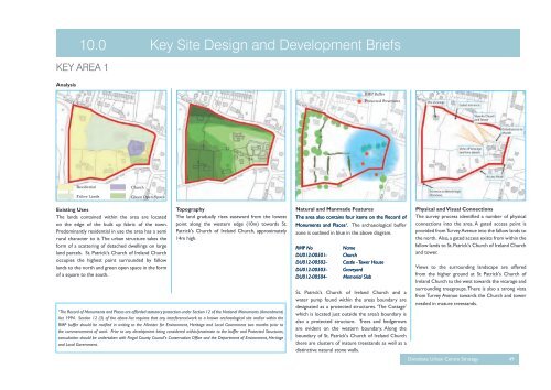
Existing Uses<br />
The lands contained within the area are located<br />
on the edge of the built up fabric of the town.<br />
Predominantly residential in use the area has a semi<br />
rural character to it. The urban structure takes the<br />
form of a scattering of detached dwellings on large<br />
land parcels. St. Patrick's Church of Ireland Church<br />
occupies the highest point surrounded by fallow<br />
lands to the north and green open space in the form<br />
of a square to the south.<br />
Topography<br />
The land gradually rises eastward from the lowest<br />
point along the western edge (10m) towards St.<br />
Patrick's Church of Ireland Church, approximately<br />
14m high.<br />
¹The Record of Monuments and Places are afforded statutory protection under Section 12 of the National Monuments (Amendment)<br />
Act 1994. Section 12 (3) of the above Act requires that any interference/work to a known archaeological site and/or within the<br />
RMP buffer should be notified in writing to the Minister for Environment, Heritage and Local Government two months prior to<br />
the commencement of work. Prior to any development being considered within/proximate to the buffer and Protected Structures,<br />
consultation should be undertaken with <strong>Fingal</strong> <strong>County</strong> <strong>Council</strong>'s Conservation Office and the Department of Environment, Heritage<br />
and Local Government.<br />
RMP Buffer<br />
Protected Structures<br />
Natural and Manmade Features<br />
The area also contains four items on the Record of<br />
Monuments and Places¹. The archaeological buffer<br />
zone is outlined in blue in the above diagram.<br />
RMP No Name<br />
DU012-00501- Church<br />
DU012-00502- Castle - Tower House<br />
DU012-00503- Graveyard<br />
DU012-00504- Memorial Slab<br />
St. Patrick's Church of Ireland Church and a<br />
water pump found within the areas boundary are<br />
designated as a protected structures. ‘The Cottage’<br />
which is located just outside the area’s boundary is<br />
also a protected structure. Trees and hedgerows<br />
are evident on the western boundary. Along the<br />
boundary of St. Patrick's Church of Ireland Church<br />
there are clusters of mature treestands as well as a<br />
distinctive natural stone walls.<br />
Physical and Visual Connections<br />
The survey process identified a number of physical<br />
connections into the area. A gated access point is<br />
provided from Turvey Avenue into the fallow lands to<br />
the north. Also, a gated access exists from within the<br />
fallow lands to St. Patrick's Church of Ireland Church<br />
and tower.<br />
Views to the surrounding landscape are offered<br />
from the higher ground at St Patrick's Church of<br />
Ireland Church to the west towards the vicarage and<br />
surrounding treegroups. There is also a strong vista<br />
from Turvey Avenue towards the Church and tower<br />
nestled in mature treestands.<br />
<strong>Donabate</strong> <strong>Urban</strong> <strong>Centre</strong> <strong>Strategy</strong> 49


