

Donabate Urban Centre Strategy Fingal County Council
Donabate Urban Centre Strategy Fingal County Council
Donabate Urban Centre Strategy Fingal County Council

Create successful ePaper yourself
Turn your PDF publications into a flip-book with our unique Google optimized e-Paper software.
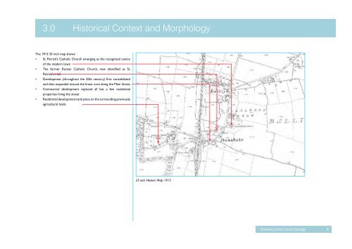
The 1913 25 inch map shows:<br />
•<br />
•<br />
•<br />
•<br />
•<br />
3.0 Historical Context and Morphology<br />
St. Patrick’s Catholic Church emerging as the recognised centre<br />
of the modern town<br />
The former Roman Catholic Church, now identified as St.<br />
Patrick's Hall.<br />
Development (throughout the 20th century) first consolidated<br />
and then expanded around the linear core along the Main Street.<br />
Commercial development replaced all but a few residential<br />
properties lining the street<br />
Residential development took place on the surrounding previously<br />
agricultural lands.<br />
25 inch Historic Map: 1913<br />
<strong>Donabate</strong> <strong>Urban</strong> <strong>Centre</strong> <strong>Strategy</strong> 8


