

Donabate Urban Centre Strategy Fingal County Council
Donabate Urban Centre Strategy Fingal County Council
Donabate Urban Centre Strategy Fingal County Council

Create successful ePaper yourself
Turn your PDF publications into a flip-book with our unique Google optimized e-Paper software.
3.0 Historical Context and Morphology<br />
3.1 Historical Context and <strong>Urban</strong> Morphology<br />
Although there is evidence of human habitation in the area from the<br />
Mesolithic period onwards, the present urban structure began to<br />
develop around the medieval ecclesiastical foundation in <strong>Donabate</strong><br />
townland, which was in existence by the early 13th century.<br />
A thriving economy based on fishing and limestone quarrying fuelled<br />
a period of significant development in the 18th century. The town<br />
underwent further significant change with the construction of the<br />
Dublin-Belfast railway line in the mid 19th century.<br />
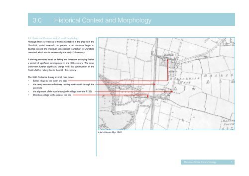
The 1841 Ordnance Survey six-inch map shows:<br />
• Ballisk village to the north and east<br />
• the newly constructed railway running north-south through the<br />
peninsula<br />
• the alignment of the road through the village (now the R126)<br />
• <strong>Donabate</strong> village to the west of the line<br />
6 inch Historic Map: 1841<br />
<strong>Donabate</strong> <strong>Urban</strong> <strong>Centre</strong> <strong>Strategy</strong> 7


