Leica GS09 GNSS Datasheet - Arctron
Leica GS09 GNSS Datasheet - Arctron
Leica GS09 GNSS Datasheet - Arctron

You also want an ePaper? Increase the reach of your titles
YUMPU automatically turns print PDFs into web optimized ePapers that Google loves.
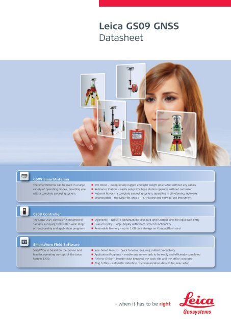
<strong>GS09</strong> SmartAntenna<br />
The SmartAntenna can be used in a large<br />
variety of operating modes, providing you<br />
with a complete surveying system.<br />
CS09 Controller<br />
The <strong>Leica</strong> CS09 controller is designed to<br />
suit any surveying task with a wide range<br />
of functionality and application programs.<br />
SmartWorx Field Software<br />
SmartWorx is based on the proven and<br />
familiar operating concept of the <strong>Leica</strong><br />
System 1200.<br />
<strong>Leica</strong> <strong>GS09</strong> <strong>GNSS</strong><br />
<strong>Datasheet</strong><br />
n RTK Rover – exceptionally rugged and light weight pole setup without any cables<br />
n Reference Station – easily setup RTK base station operates without controller<br />
n Network Rover – a complete surveying system, operating in all reference networks<br />
n SmartStation – the <strong>GS09</strong> fits onto a TPS creating one easy-to-use instrument<br />
n Ergonomic – QWERTY alphanumeric keyboard and function keys for rapid data entry<br />
n Colour Display – large display with touch screen functionality<br />
n Removable Memory – up to 1 GB data storage on CompactFlash card<br />
n Icon-based Menus – quick to learn, ensuring instant productivity<br />
n Application Programs – enable any survey task to be easily and efficiently completed<br />
n Field-to-Office – transfer data between the work site and the office computer<br />
n Plug & Play – automatic detection of communication devices for easy setup
<strong>Leica</strong> <strong>GS09</strong> SmartAntenna<br />
<strong>GNSS</strong> Technology Measurement Engine<br />
<strong>Leica</strong> patented SmartTrack+ • Jamming resistant measurements<br />
technology<br />
• High precision pulse aperture multipath correlator<br />
• Excellent low elevation tracking technology<br />
• Very low noise <strong>GNSS</strong> carrier phase measurements<br />
with
<strong>Leica</strong> CS09 Controller<br />
User Interface Standard software<br />
Operating system Microsoft Windows CE 5.0 software<br />
Application software <strong>Leica</strong> SmartWorx field software<br />
Terminal software<br />
Software control<br />
<strong>Leica</strong> GX1200 sensor control<br />
Display ¼ VGA colour, graphics capable<br />
Touch screen Toughened film on glass<br />
Keyboard 62 keys with QWERTY alphanumeric & function keys<br />
Illumination Backlight illuminated display and fully illuminated keys<br />
Hardware Physical<br />
Dimension 218 mm x 123 mm x 47 mm<br />
Weight of CS09 740 g including battery<br />
Weight of pole setup 3.47 kg for complete rover pole setup<br />
Weight of network rover 2.85 kg for complete network rover using a Bluetooth ® Interfaces<br />
mobile phone<br />
Data storage Removable CF card (256 MB and 1 GB available)<br />
Communication ports • Combined USB/Power port with 8-pin Lemo plug<br />
• 2 x Bluetooth ® ports Class 2<br />
• 7-pin clip on contacts for GHT56 SmartHolder connection<br />
Environmental Specifications<br />
Temperature, operating -30° C to +65° C (-22° F to +149° F) 3<br />
Temperature, storage -40° C to +80° C (-40° F to +176° F) 3<br />
Humidity 100% 4<br />
Sealed against water IP67: Temporary submersion into water (max. depth 1 m)<br />
Sealed against sand and dust Dust tight, protection against blowing dust<br />
Drops Withstands 1.5 m drop onto hard surface<br />
Vibration<br />
Power Management<br />
Withstands vibrations in compliance with ISO9022-36-08<br />
Supply Voltage Nominal 12 V DC, Range 11.5 – 28 V DC<br />
Power consumption Typically: 1.4 W, 120 mA<br />
Internal Power supply Removable & rechargable Li-Ion battery,<br />
GEB211 2.2 Ah / 7.4 V or GEB212 2.6 Ah / 7.4 V<br />
Operation time Up to 13 hours using GEB212 battery 5<br />
Communications RTK specifications<br />
Data Formats <strong>Leica</strong> propriety formats (<strong>Leica</strong>, <strong>Leica</strong> Lite, <strong>Leica</strong> 4G)<br />
Optional CMR, CMR+, RTCM 2.1, RTCM 2.3, RTCM 3.0, RTCM 3.1<br />
RTK baseline Optional 5 km maximum baseline or unlimited baseline lengths<br />
Position update rate 1 Hz standard. Optional 20 Hz (0.05 sec)<br />
Network Rover<br />
External Devices<br />
VRS, FKP, iMAX, MAX, Nearest station<br />
Radio Modem Satelline and Pacific Crest radios in GFU housing<br />
(connected using GHT56 SmartHolder)<br />
Mobile Phone • GSM / CDMA modules in GFU housing<br />
(connected using GHT56 SmartHolder)<br />
• Bluetooth ® mobile phones<br />
<strong>GS09</strong> SmartAntenna • Bluetooth ®<br />
• USB Cable<br />
PC with Microsoft Windows • USB data cable<br />
• CF-card reader<br />
Internet Mobile phone using FTP protocol<br />
1 Measurement precision, accuracy and reliability are dependent upon various factors including number of satellites, geometry,<br />
obstructions, observation time, ephemeris accuracy, ionospheric conditions, multipath etc. Figures quoted assume normal to<br />
favorable conditions. GPS and GLONASS can increase performance and accuracy by up to 30% relative to GPS only.<br />
2 May vary due to atmospheric conditions, multipath, obstructions, signal geometry and number of tracked signals.<br />
3 Compliance with ISO9022-10-08, ISO9022-11-special and MIL-STD-810F Method 502.4-II, MIL-STD-810F Method 501.4-II<br />
4 Compliance with ISO9022-13-06, ISO9022-12-04 and MIL-STD-810F Method 507.4-I<br />
5 May vary with temperature and battery age.
<strong>Leica</strong> SmartWorx Field Software<br />
Operation<br />
Reference Line<br />
Always in view status information bar<br />
Staking of line, arcs and polylines<br />
Permanent display of current positioning accuracy<br />
Staking of chainages<br />
Data import: ASCII, DXF, GSI, DTM models<br />
Staking of slopes<br />
Data export: Custom ASCII, DXF, XML, Raw data<br />
Quality comparison between stake and design<br />
Field-to-Office data transfer using ftp<br />
Graphical display of design<br />
Setup Reference<br />
RoadRunner<br />
Configuration of RTK base station for operation without requiring a controller Staking of alignments:<br />
Selection of antenna type<br />
Stringlines, single/double cross slopes, batters, surfaces<br />
Selection of radio channel<br />
Graphical staking and quality control<br />
Computation of navigated base position<br />
Alignments can be created in the field<br />
GPS Resection<br />
Importing of alignments from various design formats<br />
Provides a rapid localisation of a GPS job<br />
Comprehensive field report of completed work<br />
Positions onto existing control points<br />
Volume Calculations<br />
Uses a similar method as a TPS resection<br />
Computation of surface areas and volumes<br />
Requires no knowledge of coordinate systems<br />
Using imported or measured points<br />
Determine Coordinate Systems<br />
Graphical display of triangles<br />
For the conversion of <strong>GNSS</strong> positions to local coordinates<br />
DXF export of measured surfaces<br />
Provides a Onestep, Twostep or Classic 3D transformation type<br />
Comprehensive reporting<br />
One point localisation for rapid calibration<br />
DTM Stakeout<br />
Display and recording of parameters and residuals<br />
Staking out of heights based on a digital terrain model<br />
Automatic matching of measured and entered points<br />
Staking out of points with heights taken from the DTM<br />
Coordinate Geometry<br />
Various DTM layers can be selected for stakeout<br />
Inverse, intersections, line and arc related computations<br />
Can be used for quality control of design surface<br />
Calculations made from entered or measured points<br />
Functionality Options<br />
Graphical plot view of computations<br />
GLONASS satellite tracking<br />
Coding of calculated points<br />
Raw data logging for post-processing<br />
Immediate stakeout of calculated points<br />
RTK functionality with unlimited baseline length<br />
Survey<br />
Position and display update rate of 5 Hz (0.2 sec)<br />
Manual or automated point measurement<br />
Reference network access (includes unlimited baseline)<br />
Configurable display layout<br />
RTCM/CMR RTK data messages input<br />
Point, line, area or free coding<br />
Bluetooth<br />
Smart and Quick coding<br />
Measuring of hidden points using offset data<br />
Stakeout<br />
Orientation to north, point, line, sun or by arrow<br />
Quality comparison between stake and design<br />
Automatic selection of closest design point<br />
Graphical selection of point from map display<br />
Design height editing during stakeout<br />
® Standard features Optional features<br />
mobile phone connection<br />
NMEA out<br />
Illustrations, descriptions and technical data are not binding. All rights reserved. Printed in Switzerland –<br />
Copyright <strong>Leica</strong> Geosystems AG, Heerbrugg, Switzerland, 2009. 774769en – VII.11 – RDV<br />
<strong>Leica</strong> Geosystems AG<br />
Heerbrugg, Switzerland<br />
www.leica-geosystems.com<br />
Total Quality Management –<br />
our commitment to total<br />
customer satisfaction.<br />
The Bluetooth ® word mark and<br />
logos are owned by Bluetooth<br />
SIG, Inc. and any use of such<br />
marks by <strong>Leica</strong> Geosystems AG is<br />
under license.