Facts about Västernorrland 2009 Facts about Västernorrland 2009
Facts about Västernorrland 2009 Facts about Västernorrland 2009 Facts about Västernorrland 2009 Facts about Västernorrland 2009
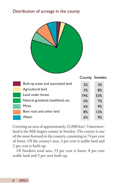
Distribution of acreage in the county 8 Built-up areas and associated land Agricultural land Land under forest Natural grassland, heathland, etc. Mires Bare rock and other land Water AREA County Sweden 2% 3% 3% 8% 74% 53% 0% 7% 6% 9% 8% 12% 6% 9% Covering an area of approximately 23,000 km 2 , Västernorrland is the fi fth largest county in Sweden. The county is one of the most forested in the country, consisting to 74 per cent of forest. Of the county’s area, 3 per cent is arable land and 2 per cent is built-up. Of Sweden’s total area, 53 per cent is forest, 8 per cent arable land and 3 per cent built-up.
Highest and lowest temperatures in the county Station Highest Highest Lowest Lowest 2008 since 1901 2008 since 1901 Junsele 30.1 32.2 -26.1 -45.8 Skagsudde 25.5 30.0 -13.3 -31.3 Härnösand 28.1 32.7 -17.9 -34.7 Torpshammar 32.3 34.6 -21.5 -42.0 Sundsvall 29.1 33.0 -17.3 -36.6 Västernorrland in comparison with Sweden Station Mean annual temp. C Annual precipitation mm 2008 Norm value 2008 Norm value 1961-90 1961-90 Kiruna -0.4 -1.9 627 500 Luleå 3.3 1.6 565 506 Junsele 3.3 1.5 511 551 Skagsudde 5.8 3.4 403 426 Härnösand 5.7 3.8 776 703 Sundsvall 5.1 3.1 615 539 Stockholm 8.5 6.6 634 539 Gothenburg 9.7 7.7 1,059 758 Lund 9.5 7.9 667 666 CLIMATE 99
- Page 1 and 2: Facts about Västernorrland 2009
- Page 3 and 4: Welcome to Västernorrland! Our cou
- Page 5 and 6: The High Coast Naturum Photo: Lena
- Page 7 and 8: engineering. Other important cluste
- Page 9: Västernorrland County Municipality
- Page 13 and 14: Population changes 2007-2008 Change
- Page 15 and 16: Net migration Västernorrland Count
- Page 17 and 18: 100 000 80 000 60 000 40 000 20 000
- Page 19 and 20: Length of roads, km State Roads 200
- Page 21 and 22: Commuting across municipality borde
- Page 23 and 24: Airport are state-maintained, and K
- Page 25 and 26: Photo: Ida Lundmark
- Page 27 and 28: Sundsvall inner harbour Photo: Anna
- Page 29 and 30: Electricity consumption per county
- Page 31 and 32: Municipal gross costs 2007, SEK/ in
- Page 33 and 34: Total earned income 2007 by age gro
- Page 35 and 36: Protected nature Skuleskogen Nation
- Page 37 and 38: Workplaces in Västernorrland Count
- Page 39 and 40: Newly-started companies, 2007 Count
- Page 41 and 42: Gainfully employed, 2007 (%) 5 40 4
- Page 43 and 44: Gainfully employed by sector in 200
- Page 45 and 46: Unemployment 2008 (%) In labour mar
- Page 47 and 48: 3.9 million overnight stays and 5.6
- Page 49 and 50: Commercial overnight stays 1988-200
- Page 51 and 52: Length of education of men and wome
- Page 53 and 54: Education There is a good teacher s
- Page 55 and 56: Photo: Michael Engman
- Page 57 and 58: kus Elvira and a vast world of amat
- Page 59 and 60: Use of arable land in Västernorrla
Distribution of acreage in the county<br />
8<br />
Built-up areas and associated land<br />
Agricultural land<br />
Land under forest<br />
Natural grassland, heathland, etc.<br />
Mires<br />
Bare rock and other land<br />
Water<br />
AREA<br />
County Sweden<br />
2% 3%<br />
3% 8%<br />
74% 53%<br />
0% 7%<br />
6% 9%<br />
8% 12%<br />
6% 9%<br />
Covering an area of approximately 23,000 km 2 , <strong>Västernorrland</strong><br />
is the fi fth largest county in Sweden. The county is one<br />
of the most forested in the country, consisting to 74 per cent<br />
of forest. Of the county’s area, 3 per cent is arable land and<br />
2 per cent is built-up.<br />
Of Sweden’s total area, 53 per cent is forest, 8 per cent<br />
arable land and 3 per cent built-up.


