

Dr. Norm Catto Coastal Erosion in NL.pdf - Atlantic Climate ...
Dr. Norm Catto Coastal Erosion in NL.pdf - Atlantic Climate ...
Dr. Norm Catto Coastal Erosion in NL.pdf - Atlantic Climate ...

Create successful ePaper yourself
Turn your PDF publications into a flip-book with our unique Google optimized e-Paper software.
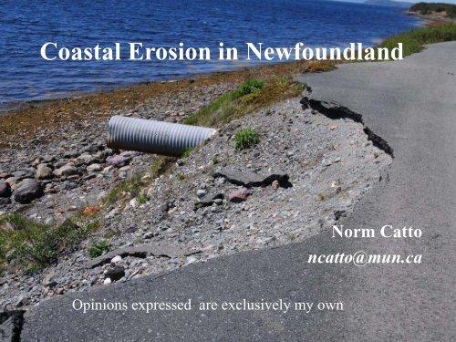
<strong>Coastal</strong> <strong>Erosion</strong> <strong>in</strong> Newfoundland<br />
Op<strong>in</strong>ions expressed are exclusively my own<br />
<strong>Norm</strong> <strong>Catto</strong><br />
ncatto@mun.ca
<strong>Coastal</strong> Zones<br />
Ris<strong>in</strong>g sea level & erosion are<br />
occurr<strong>in</strong>g<br />
If your property is erod<strong>in</strong>g, the cause is<br />
less important than is tak<strong>in</strong>g action<br />
Adaptive capacity exists & should be<br />
utilized
<strong>Coastal</strong> Zone - Research<br />
ongo<strong>in</strong>g monitor<strong>in</strong>g of sensitive coastal<br />
areas<br />
base-l<strong>in</strong>e data for coastal erosion<br />
<strong>in</strong>vestigation of the effects of<br />
storm surge activity<br />
analysis of wave &surge dynamics<br />
rates and processes of coastal bluff erosion<br />
consideration of the effectiveness of<br />
adaptation strategies
Study Parameters<br />
Newfoundland (<strong>in</strong>clud<strong>in</strong>g adjacent islands)<br />
122 1:50,000 scale maps<br />
Field, office, laboratory research May 2010-2012<br />
March 2011 summary report<br />
Detailed community reports – Ferryland, Corner Brook,<br />
Irishtown-Summerside, Fortune, Lumsden, Indian Bay,<br />
Logy Bay-Middle Cove-Outer Cove<br />
Ongo<strong>in</strong>g study of other <strong>in</strong>dividual locations
Components<br />
Shorel<strong>in</strong>e Classification of coastal geomorphology &<br />
sedimentology at ~50 m <strong>in</strong>tervals (~193,000 pts)<br />
Sensitivity to short-term coastal erosion, through new<br />
<strong>Coastal</strong> <strong>Erosion</strong> Index (CEI) (1472 locations)<br />
Sensitivity to long-term coastal erosion & sea-level rise,<br />
<strong>Coastal</strong> Sensitivity Index (CSI) (1472 locations)<br />
Petroleum Vulnerability Index (PVI) (1472 locations)
Shorel<strong>in</strong>e Classification System<br />
“Substrate”: rock and /or sediment<br />
Sediment type: by texture<br />
Width: “wide” > 30 m, “narrow” ≤ 30 m<br />
Steepness: “steep” > 20°; gentle ≤ 20°<br />
27 possible categories
Ferryland (S): 13, wide gravel flat
Fortune E:<br />
18, Steep Gravel & Sand Beach
<strong>Coastal</strong> <strong>Erosion</strong> Index<br />
sediment type (parameter values 1-4)<br />
shorel<strong>in</strong>e classification (1-5)<br />
sediment flux (1-5)<br />
aspect (1-5)<br />
extent of seasonal ice and snow cover (1-2)<br />
CEI = (product of five parameter values / 10)<br />
Higher CEI value <strong>in</strong>dicates greater sensitivity to shortterm<br />
coastal erosion
Corner Brook CEI = 8.0
Middle Cove CEI = 20
CEI<br />
Very Low Sensitivity: CEI 20.0<br />
Median for Newfoundland 10.3
<strong>Coastal</strong> Sensitivity Index<br />
sea-level change (amount of rise or fall per year) (1-5);<br />
Relief (1-5);<br />
mean annual maximum significant wave height;<br />
rock and/or sediment type exposed along the shore;<br />
landform type (e.g. cliff, beach, salt marsh);<br />
shorel<strong>in</strong>e displacement (laterally, expressed <strong>in</strong> m/a); and<br />
tidal range<br />
CSI = √ (product of scores of all 7 parameters/7)<br />
Higher CSI values <strong>in</strong>dicate sensitivity to long-term<br />
erosion
Fortune Head CSI =7.3
Lumsden E CSI = 39.4
CSI<br />
Very Low Sensitivity: CSI 35.0<br />
Median for Newfoundland: 18.5
Petroleum Exposure<br />
Mar<strong>in</strong>e Exposure (M) (1-5)<br />
Terrestrial Exposure (T) (1-2.5)<br />
Current Direction (D) (1-2)<br />
Maximum Exposure Value = M 2 *T*D = 125
Petroleum Sensitivity<br />
Shorel<strong>in</strong>e Class and sediment type (S) 1-5<br />
Energy Level (E)<br />
Energy Regime (R)<br />
Maximum Sensitivity Value = S *E* R = 125
Petroleum Vulnerability Index<br />
PVI = √{(S *E* R) (M 2 *T*D)}<br />
The maximum possible value for the PVI is √(125)*(125)<br />
= 125<br />
Median 17.1
PVI<br />
Very Low Sensitivity: PVI 35.0<br />
Median for Newfoundland 17.1
Site Shorel<strong>in</strong>e CEI CSI PVI<br />
Belloram Gravel and Sand<br />
Beach<br />
11.3<br />
moderate<br />
Boxey Gravel & Sand Flat 22.7<br />
very high<br />
Harbour<br />
Breton<br />
Gravel and Sand<br />
Beach and Flat<br />
Dawsons Cove Sand and Gravel<br />
Beach<br />
Gaultois Gravel Beach and<br />
Rock Cliff<br />
St. Alban’s Gravel and Sand<br />
Beach and Rock Cliff<br />
11.3<br />
moderate<br />
33.7<br />
extreme<br />
12.0<br />
moderate<br />
8.0<br />
low<br />
24.7<br />
high<br />
30.1<br />
high<br />
21.2<br />
moderate<br />
27.8<br />
high<br />
14.4<br />
low<br />
27.2<br />
high<br />
19.6<br />
low<br />
18.0<br />
low<br />
18.0<br />
low<br />
Island median --- 10.3 18.5 17.1<br />
22.0<br />
moderate<br />
14.7<br />
Very low<br />
23.2<br />
moderate
Site Shorel<strong>in</strong>e Classification CEI CSI PVI<br />
Ferryland N 6: Gravel Beach w. Rock Cliff<br />
8.4<br />
24.5<br />
14.7<br />
9: Gravel & Sand Beach with Rock Cliff<br />
low<br />
high<br />
very low<br />
Ferryland Head 6: Gravel Beach w. Rock Cliff<br />
6.4<br />
15.9<br />
12.3<br />
3: Rock Cliff<br />
low<br />
moderate very low<br />
Ferryland 15: Steep Gravel Beach<br />
32.0<br />
28.7<br />
13.9<br />
18: Steep Gravel & Sand Beach<br />
extreme<br />
high<br />
very low<br />
Ferryland S 13/14/15: Wide to Narrow Gravel Flat; Steep 14.4<br />
22.6<br />
14.7<br />
Gravel Beach<br />
6: Gravel Beach w. Rock Cliff<br />
moderate moderate very low
t LaHaye


