GEUS Bulletin no 5.pmd
GEUS Bulletin no 5.pmd
GEUS Bulletin no 5.pmd

You also want an ePaper? Increase the reach of your titles
YUMPU automatically turns print PDFs into web optimized ePapers that Google loves.
part, and are followed by mudstones of the Bernbjerg<br />
Formation that yield Upper Oxfordian – Lower Kimmeridgian<br />
ammonites (Surlyk 1978). The outcrops at<br />
Kulhus and Agnetesøelven expose the main part of<br />
the Jurassic succession in Hochstetter Forland. These<br />
localities were visited during fieldwork in 1987 in order<br />
to collect material for paly<strong>no</strong>logical analysis with<br />
the aim of refining the stratigraphy. The present paper<br />
describes for the first time the di<strong>no</strong>flagellate cyst floras<br />
from these <strong>no</strong>rthern outcrops close to the transition to<br />
the Boreal di<strong>no</strong>flagellate cyst province, for example in<br />
Peary Land (Håkansson et al. 1981) and on Svalbard<br />
(Århus 1988).<br />
90<br />
Agnetesø 2 3<br />
Kulhus<br />
1<br />
20ºW<br />
Agnetesøelven<br />
Na<strong>no</strong>k<br />
Søndre<br />
Muslingebjerg<br />
20 km<br />
N<br />
76º30'N<br />
Greenland<br />
HOCHSTETTER<br />
FORLAND 1: Milne Land<br />
2: Jameson Land<br />
3: Wollaston Forland<br />
4: Hochstetter Forland<br />
5: Store Koldewey<br />
6: Germania Land<br />
7: Peary Land<br />
Undifferentiated,<br />
mostly glacial deposits<br />
Cretaceous<br />
Jurassic<br />
Caledonian<br />
crystalline basement<br />
Locality<br />
Fault<br />
7<br />
6<br />
4<br />
3<br />
1<br />
500 km<br />
Material<br />
<strong>GEUS</strong> <strong>Bulletin</strong> <strong>no</strong> <strong>5.pmd</strong> 90<br />
29-10-2004, 11:14<br />
1<br />
5<br />
2<br />
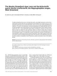
Fig. 1. Simplified sketch map of Hochstetter<br />
Forland illustrating the Jurassic<br />
outcrops and the sampled localities.<br />
The map is modified from Surlyk<br />
(1978, fig. 1).<br />
At Kulhus (Fig. 1; Locality 1), on the south coast of<br />
Hochstetter Forland west of Søndre Muslingebjerg, sand<br />
and coal seams were sampled during a ground stop<br />
on helicopter reconnaissance in 1987. Only one sample<br />
(GGU 351570) contains di<strong>no</strong>flagellate cysts. Two<br />
closely situated localities at Agnetesøelven were spotted<br />
from the air and visited during a short ground stop.<br />
The westernmost sandstone outcrop (Locality 2) was<br />
measured and two fine-grained samples with at least<br />
some potential for paly<strong>no</strong>logy were collected from two<br />
horizons (Fig. 2). Eastwards and down-river, the sandstone-dominated<br />
succession was seen to be faulted<br />
against a succession of laminated mudstones (Locality<br />
3), and this was closely sampled for paly<strong>no</strong>logy (Fig.<br />
3). Only a few, well-preserved di<strong>no</strong>flagellate cysts were<br />
recovered from the sand succession at Locality 2. By