GEUS Bulletin no 5.pmd
GEUS Bulletin no 5.pmd
GEUS Bulletin no 5.pmd

Create successful ePaper yourself
Turn your PDF publications into a flip-book with our unique Google optimized e-Paper software.
74°00'N<br />
■■ ■■ ■■<br />
73°55'N<br />
■■ ■■ ■■ ■■<br />
Spath Plateau<br />
■■ ■■<br />
3<br />
Stensiö<br />
Plateau<br />
■■ ■■ ■■<br />
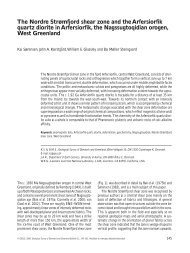
Fig. 2. Geological map of the <strong>no</strong>rthern Hold with Hope which illustrates the distribution of the studied Jurassic succession. Localities<br />
1, 2 and 3 are marked; the succession at Locality 1 has been compiled from a number of short laterally correlated sections (1A–1E).<br />
offshore mudstones that contrast with the generally<br />
coarse-grained sandstone facies of the Pelion Formation<br />
(Vosgerau et al. 2004, this volume). The succession<br />
on Hold with Hope resembles the well-k<strong>no</strong>wn<br />
Jurassic succession in the Wollaston Forland and<br />
Jameson Land Basins towards the <strong>no</strong>rth and south. The<br />
Middle Jurassic Pelion Formation is c. 190 m thick, the<br />
Upper Jurassic Payer Dal Formation is 50–80 m thick<br />
and the Bernbjerg Formation is estimated to be c. 130<br />
m thick (Fig. 4; Vosgerau et al. 2004, this volume).<br />
Samples and methods<br />
■■ ■■ ■■ ■■<br />
■■ ■■<br />
21°15'W<br />
The di<strong>no</strong>flagellate cysts have been studied in three<br />
sections (Fig. 4), in combination with a number of<br />
geographically and stratigraphically scattered samples<br />
1A<br />
Gulelv<br />
1B<br />
1C<br />
1D<br />
■■ ■■ ■■ ■■<br />
1E<br />
■■<br />
■■<br />
■■<br />
■■<br />
■■ ■■<br />
■■<br />
■■<br />
■■ ■■ ■■ ■■<br />
■■ ■■ ■■ ■■ ■■<br />
■■<br />
Sortelv<br />
■■<br />
2<br />
■■<br />
■■<br />
■■<br />
■■<br />
■■<br />
■■<br />
Ice<br />
Undifferentiated<br />
superficial deposits<br />
Dolerite sill<br />
Plateau basalt<br />
Paleocene<br />
Lower Cretaceous<br />
Middle and Upper Jurassic<br />
Lower Triassic<br />
Permian<br />
Crystalline basement<br />
2 km<br />
Steensby<br />
Bjerg<br />
■■ ■■<br />
■■ ■■ ■■<br />
21°00'<br />
Gael Hamke Bugt<br />
■■ ■■<br />
■■<br />
■■<br />
■■ ■■ ■■<br />
Normal fault<br />
Inferred fault<br />
Locality<br />
on <strong>no</strong>rthern Hold with Hope. The main area of exposure<br />
is located on the <strong>no</strong>rthern and western slopes of<br />
Steensby Bjerg towards Gael Hamke Bugt and along<br />
the Gulelv river (Fig. 2, Locality 1). Samples from a<br />
number of short, vertical sections are combined into a<br />
composite section representing the entire succession<br />
(Fig. 2, Locality 1, sections A–E). The Payer Dal Formation<br />
was also sampled at the Sortelv river, south of<br />
Steensby Bjerg (Fig. 2, Locality 2). Samples from a third<br />
section through the Pelion Formation at Stensiö Plateau<br />
(Fig. 2, Locality 3) provide good supplementary<br />
material from the lowermost part of the succession,<br />
which is poorly represented in the section at Steensby<br />
Bjerg. Most of the analysed samples are from finegrained<br />
thin beds or lamina in the otherwise coarsegrained,<br />
sandy Pelion and Payer Dal Formations. The<br />
number of samples and their stratigraphical distribu-<br />
■■<br />
■■<br />
3<br />
■■ ■■<br />
Diener Bjerg<br />
<strong>GEUS</strong> <strong>Bulletin</strong> <strong>no</strong> <strong>5.pmd</strong> 75<br />
29-10-2004, 11:14<br />
■■ ■■<br />
■■ ■■<br />
■■ ■■<br />
■■ ■■<br />
■■<br />
■■ ■■<br />
■■<br />
■■<br />
■■ ■■ ■■<br />
Hold<br />
with<br />
Hope<br />
75