GEUS Bulletin no 5.pmd
GEUS Bulletin no 5.pmd
GEUS Bulletin no 5.pmd

Create successful ePaper yourself
Turn your PDF publications into a flip-book with our unique Google optimized e-Paper software.
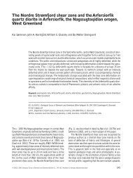
Fig. 1. Locality map of East Greenland and eastern North Greenland.<br />
The white region illustrates the permanent inland ice cap<br />
of Greenland, the grey areas are ice-free. Hold with Hope is<br />
located between 73ºN and 74ºN.<br />
74<br />
42°W 36°W 28°W 20°W 12°W<br />
Jameson<br />
Land<br />
Milne<br />
Land<br />
Scoresby Sund<br />
St. Koldewey<br />
Kuhn Ø<br />
Wollaston<br />
Forland<br />
Fig. 2<br />
Hold with Hope<br />
Geographical Society Ø<br />
Traill Ø<br />
28°W 20°W<br />
Hochstetter<br />
Forland<br />
200 km<br />
70°N<br />
improve the k<strong>no</strong>wledge of Jurassic di<strong>no</strong>flagellate cysts<br />
in this region in general. The results reported here<br />
allow correlation with corresponding assemblages from<br />
Store Koldewey and Hochstetter Forland in the <strong>no</strong>rth<br />
and Jameson Land – Milne Land in the south (Fig. 1).<br />
Geological setting<br />
<strong>GEUS</strong> <strong>Bulletin</strong> <strong>no</strong> <strong>5.pmd</strong> 74<br />
29-10-2004, 11:14<br />
82°N<br />
80°N<br />
12°W<br />
78°N<br />
76°N<br />
74°N<br />
72°N<br />
The Late Palaeozoic – Mesozoic extensional basin complex<br />
in East Greenland is approximately 700 km long<br />
in a <strong>no</strong>rth–south direction. Jurassic sediments are<br />
present and exposed from Jameson Land in the south<br />
to Store Koldewey in the <strong>no</strong>rth (Surlyk 1977). In the<br />
<strong>no</strong>rthern part of the rift system, e.g. the Wollaston Forland<br />
Basin, rifting was initiated in Middle Jurassic time,<br />
and marine Bajocian–Bathonian sandstones onlap Caledonian<br />
basement rocks or Permian carbonates (Vischer<br />
1943; Surlyk 1978). Deposition took place on the hangingwall<br />
of W–SW-tilted fault blocks. Jurassic rifting<br />
culminated in the Volgian with strong rotational block<br />
faulting (Surlyk 1978). During this episode the wide<br />
original fault blocks, defining the Wollaston Forland<br />
Basin, were divided into smaller blocks (Vischer 1943;<br />
Surlyk 1978). A similar tectonic development may have<br />
occurred in the Geographical Society Ø and Traill Ø<br />
area towards the south (Do<strong>no</strong>van 1957; Price & Whitham<br />
1997). The Cretaceous period was generally characterised<br />
by subsidence controlled by thermal contraction<br />
(Surlyk et al. 1981; Price & Whitham 1997). The<br />
East Greenland rift basin complex was uplifted during<br />
the Ce<strong>no</strong>zoic.<br />
Sediments of Jurassic age were first recognised on<br />
Hold with Hope by Stemmerik et al. (1997). They are<br />
limited to the <strong>no</strong>rth coast of Hold with Hope from<br />
Stensiö Plateau to Steensby Bjerg (Fig. 2), where they<br />
occur on the hangingwall of small fault blocks that dip<br />
mainly to the west and south-west. Bedding planes<br />
within the Triassic and Jurassic seem to be parallel,<br />
whereas the boundary with the overlying Cretaceous<br />
succession is an angular unconformity (Vosgerau et al.<br />
2004, this volume). The thickness of the Jurassic succession<br />
varies significantly depending on its position<br />
on the hangingwall and the depth of Cretaceous erosion.<br />
The Jurassic succession includes shallow marine<br />
sandstones of the Pelion and Payer Dal Formations<br />
(Vardekløft Group), and offshore transition – lower<br />
shoreface heteroliths and offshore mudstones of the<br />
Bernbjerg Formation, Hall Bredning Group (Fig. 3).<br />
The Spath Plateau Member of the Pelion Formation<br />
was erected to accommodate sandy heteroliths and