GEUS Bulletin no 5.pmd
GEUS Bulletin no 5.pmd
GEUS Bulletin no 5.pmd

You also want an ePaper? Increase the reach of your titles
YUMPU automatically turns print PDFs into web optimized ePapers that Google loves.
land Basin where deposition took place on the W–<br />
SW-tilted hangingwalls of major fault blocks and the<br />
elevated fault block crests formed elongated islands or<br />
peninsulas to the east (Vischer 1943; Maync 1947;<br />
Do<strong>no</strong>van 1957; Surlyk 1977; Surlyk et al. 1981; Surlyk<br />
& Clemmensen 1983). The presence of the marine<br />
Pelion and Payer Dal Formations in the vicinity of the<br />
block crest excludes the occurrence of a major land<br />
area during Callovian and Middle Oxfordian time when<br />
the crest probably only formed elongated islands or<br />
submarine shoals.<br />
68<br />
76ºN<br />
74ºN<br />
72ºN<br />
28ºW<br />
100 km<br />
24ºW<br />
Early–Middle Callovian<br />
Upper shoreface<br />
Lower shoreface<br />
Offshore<br />
Inferred coastline<br />
Main direction of<br />
sediment transport<br />
Jameson<br />
Land<br />
Basin<br />
20ºW 16ºW<br />
Traill Ø<br />
Hold with Hope<br />
Wollaston<br />
Forland Basin<br />
<strong>GEUS</strong> <strong>Bulletin</strong> <strong>no</strong> <strong>5.pmd</strong> 68<br />
29-10-2004, 11:14<br />
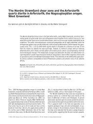
Fig. 13. Early–Middle Callovian palaeogeography<br />
and facies distribution in East<br />
Greenland. Based on Surlyk (1977),<br />
Engkilde & Surlyk (2003), Vosgerau et<br />
al. (2004, this volume), and new data<br />
from Hold with Hope.<br />
The Hold with Hope area is thus interpreted to have<br />
formed a narrow embayment which was open for<br />
marine circulation towards the south and, during periods<br />
of high sea level, eastwards across the elevated<br />
fault block crest. Farther towards the east, the fault<br />
block was most likely limited by the continuation of<br />
the Dombjerg–Clavering Fault, which was active during<br />
the Jurassic (Maync 1947; Surlyk 1977; Stemmerik<br />
et al. 1993). The narrow head of the rift-basin occurs<br />
in an intermediate position between the Wollaston<br />
Forland and Jameson Land Basins that are situated to