GEUS Bulletin no 5.pmd
GEUS Bulletin no 5.pmd
GEUS Bulletin no 5.pmd

Create successful ePaper yourself
Turn your PDF publications into a flip-book with our unique Google optimized e-Paper software.
Preface<br />
The Jurassic sedimentary succession in East and North-<br />
East Greenland reflects deposition during the early<br />
stages of rifting between Greenland and Norway. Jurassic<br />
sediments are exposed over a distance of more<br />
than 600 km, from Jameson Land in the south to Store<br />
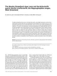
Koldewey in the <strong>no</strong>rth (Fig. 1), and form one of the<br />
best-k<strong>no</strong>wn exposed ancient rift successions. The sediments<br />
have been intensely studied over the last 25<br />
years and a synthesis of the Jurassic System in Greenland<br />
was recently given in Geological Survey of Denmark<br />
and Greenland <strong>Bulletin</strong> 1 (Surlyk 2003).<br />
This collection of papers deals with stratigraphic and<br />
depositional aspects of the Middle–Upper Jurassic sediments<br />
from isolated and less well-k<strong>no</strong>wn localities<br />
outside the main outcrop areas, and thus adds to the<br />
tremendous amount of new data generated from the<br />
classical Jurassic successions of Jameson Land and the<br />
Wollaston Forland area (Ineson & Surlyk 2003). Most<br />
papers are based on fieldwork in 1996 and 1997, carried<br />
out within the framework of the project ‘Resources<br />
of the sedimentary basins of North and East Greenland’<br />
supported by the Danish Research Councils (see<br />
Stemmerik et al. 1997). Papers dealing with the Jurassic<br />
at Store Koldewey and Hochstetter Forland are based<br />
on material collected during regional mapping in 1989<br />
(Stemmerik & Piasecki 1990).<br />
During Middle–Late Jurassic times, rifting took place<br />
along major N–S-trending synthetic faults that delimited<br />
wide westwards-tilted fault blocks (Surlyk 1977,<br />
2003). This resulted in the development of elongated<br />
marine embayments with major rivers entering from<br />
the <strong>no</strong>rth and dominantly axial sediment transport towards<br />
the south (Surlyk 1978, 2003; Engkilde & Surlyk<br />
2003). The Jurassic syn-rift succession on south-eastern<br />
Traill Ø is an exception to this general pattern<br />
(Vosgerau et al. 2004a, this volume). Sedimentation took<br />
place on an eastwards-tilted fault block; the succession<br />
shows an eastwards proximal–distal decrease in<br />
sandstone–mudstone ratio, reflecting increasing water<br />
depths to the east. On the adjacent fault block to the<br />
west, a new lithostratigraphic unit, the Bristol Elv Formation,<br />
has been erected to describe a succession of<br />
fluvio-lacustrine sediments at the base of the Middle<br />
Jurassic rift succession (Therkelsen & Surlyk 2004, this<br />
volume). The <strong>no</strong>n-marine succession is overlain by<br />
shallow marine sandstones of the Pelion Formation<br />
(Upper Bajocian), succeeded in turn by 25–30 m of<br />
black silty mudstones of the Fossilbjerget Formation<br />
6<br />
Greenland<br />
Jurassic<br />
Fault<br />
SAF<br />
Stauning<br />
Alper Fault<br />
Post-Devonian<br />
PDMF<br />
Main Fault<br />
Dombjerg<br />
DF<br />
Fault<br />
<strong>GEUS</strong> <strong>Bulletin</strong> <strong>no</strong> <strong>5.pmd</strong> 6<br />
29-10-2004, 11:13<br />
26°W<br />
28°W<br />
Milne<br />
Land<br />
22°W 20°W<br />
24°W<br />
SAF<br />
C C'<br />
Fig. 1. Simplified geological map of East and North-East Greenland<br />
showing the distribution of Jurassic sediments. Modified<br />
from Surlyk (2003).<br />
PDMF<br />
A<br />
DF<br />
Kong Oscar Fjord<br />
Jameson<br />
Land<br />
18°W 16°W<br />
Store<br />
Koldewey<br />
Hochstetter<br />
Forland<br />
Geographical<br />
Society Ø<br />
Traill Ø<br />
76°N<br />
Wollaston<br />
Forland<br />
74°N<br />
Hold with<br />
Hope<br />
72°N<br />
Liverpool<br />
Land<br />
26°W<br />
100 km<br />
24°W<br />
22°W