GEUS Bulletin no 5.pmd
GEUS Bulletin no 5.pmd
GEUS Bulletin no 5.pmd

Create successful ePaper yourself
Turn your PDF publications into a flip-book with our unique Google optimized e-Paper software.
E W<br />
Pb<br />
Geological setting<br />
The Late Palaeozoic – Mesozoic extensional basin complex<br />
in East Greenland is about 700 km long in a <strong>no</strong>rth–<br />
south direction. This complex is situated over structurally<br />
controlled en echelon troughs and forms a wedgeshaped<br />
embayment with the narrowest onshore part<br />
to the <strong>no</strong>rth. Jurassic sediments are present in the<br />
Wollaston Forland and Jameson Land Basins situated<br />
on the western margin of the rift complex. In both<br />
basins, sediment transport in Middle Jurassic time was<br />
mainly longitudinal from <strong>no</strong>rth to south along a low<br />
gradient basin floor, which was <strong>no</strong>t differentiated into<br />
a shelf, slope and deep-water basin (Surlyk 1977, 1990,<br />
1991; Surlyk et al. 1981; Surlyk & Clemmensen 1983).<br />
In the Wollaston Forland Basin, rifting was initiated<br />
in Middle Jurassic time, and marine Bajocian–Bathonian<br />
sandstones onlap weathered Caledonian basement<br />
rocks or Upper Permian carbonates. Deposition took<br />
place on the hangingwall of wide W–SW-tilted fault<br />
blocks. Jurassic rifting culminated in the Volgian with<br />
strong rotational block faulting associated with conglomeratic<br />
submarine fan sedimentation (Surlyk 1978).<br />
During this tectonic episode, the wide fault blocks originally<br />
defining the Wollaston Forland Basin were split<br />
into smaller blocks (Vischer 1943; Surlyk 1978).<br />
The Jurassic sediments on Hold with Hope occur<br />
54<br />
Tr<br />
LC<br />
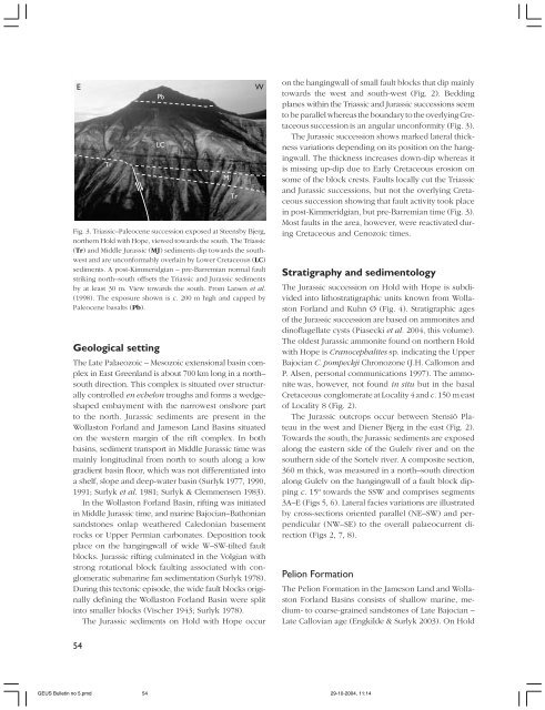
Fig. 3. Triassic–Paleocene succession exposed at Steensby Bjerg,<br />
<strong>no</strong>rthern Hold with Hope, viewed towards the south. The Triassic<br />
(Tr) and Middle Jurassic (MJ) sediments dip towards the southwest<br />
and are unconformably overlain by Lower Cretaceous (LC)<br />
sediments. A post-Kimmeridgian – pre-Barremian <strong>no</strong>rmal fault<br />
striking <strong>no</strong>rth–south offsets the Triassic and Jurassic sediments<br />
by at least 30 m. View towards the south. From Larsen et al.<br />
(1998). The exposure shown is c. 200 m high and capped by<br />
Paleocene basalts (Pb).<br />
MJ<br />
Tr<br />
on the hangingwall of small fault blocks that dip mainly<br />
towards the west and south-west (Fig. 2). Bedding<br />
planes within the Triassic and Jurassic successions seem<br />
to be parallel whereas the boundary to the overlying Cretaceous<br />
succession is an angular unconformity (Fig. 3).<br />
The Jurassic succession shows marked lateral thickness<br />
variations depending on its position on the hangingwall.<br />
The thickness increases down-dip whereas it<br />
is missing up-dip due to Early Cretaceous erosion on<br />
some of the block crests. Faults locally cut the Triassic<br />
and Jurassic successions, but <strong>no</strong>t the overlying Cretaceous<br />
succession showing that fault activity took place<br />
in post-Kimmeridgian, but pre-Barremian time (Fig. 3).<br />
Most faults in the area, however, were reactivated during<br />
Cretaceous and Ce<strong>no</strong>zoic times.<br />
Stratigraphy and sedimentology<br />
The Jurassic succession on Hold with Hope is subdivided<br />
into lithostratigraphic units k<strong>no</strong>wn from Wollaston<br />
Forland and Kuhn Ø (Fig. 4). Stratigraphic ages<br />
of the Jurassic succession are based on ammonites and<br />
di<strong>no</strong>flagellate cysts (Piasecki et al. 2004, this volume).<br />
The oldest Jurassic ammonite found on <strong>no</strong>rthern Hold<br />
with Hope is Cra<strong>no</strong>cephalites sp. indicating the Upper<br />
Bajocian C. pompeckji Chro<strong>no</strong>zone (J.H. Callomon and<br />
P. Alsen, personal communications 1997). The ammonite<br />
was, however, <strong>no</strong>t found in situ but in the basal<br />
Cretaceous conglomerate at Locality 4 and c. 150 m east<br />
of Locality 8 (Fig. 2).<br />
The Jurassic outcrops occur between Stensiö Plateau<br />
in the west and Diener Bjerg in the east (Fig. 2).<br />
Towards the south, the Jurassic sediments are exposed<br />
along the eastern side of the Gulelv river and on the<br />
southern side of the Sortelv river. A composite section,<br />
360 m thick, was measured in a <strong>no</strong>rth–south direction<br />
along Gulelv on the hangingwall of a fault block dipping<br />
c. 15º towards the SSW and comprises segments<br />
3A–E (Figs 5, 6). Lateral facies variations are illustrated<br />
by cross-sections oriented parallel (NE–SW) and perpendicular<br />
(NW–SE) to the overall palaeocurrent direction<br />
(Figs 2, 7, 8).<br />
Pelion Formation<br />
<strong>GEUS</strong> <strong>Bulletin</strong> <strong>no</strong> <strong>5.pmd</strong> 54<br />
29-10-2004, 11:14<br />
The Pelion Formation in the Jameson Land and Wollaston<br />
Forland Basins consists of shallow marine, medium-<br />
to coarse-grained sandstones of Late Bajocian –<br />
Late Callovian age (Engkilde & Surlyk 2003). On Hold