GEUS Bulletin no 5.pmd
GEUS Bulletin no 5.pmd
GEUS Bulletin no 5.pmd

You also want an ePaper? Increase the reach of your titles
YUMPU automatically turns print PDFs into web optimized ePapers that Google loves.
74º00'N<br />
■■ ■■ ■■<br />
73º55'N<br />
■■ ■■ ■■ ■■<br />
Spath Plateau<br />
2 km<br />
■■■■<br />
1<br />
■■ ■■ ■■<br />
Blåelv<br />
Stensiö<br />
Plateau<br />
■■ ■■ ■■ ■■<br />
■■ ■■<br />
21º15'W<br />
3A<br />
3B<br />
3C<br />
3D<br />
most likely that the absence was secondary owing to<br />
pre-Aptian erosion of the Jurassic rocks. Based on comparison<br />
with nearby Clavering Ø, Stemmerik et al.<br />
(1993) suggested that Middle–Upper Jurassic sediments<br />
were present in the subsurface east of the continuation<br />
of the Dombjerg–Clavering Fault on Hold with<br />
Hope (Fig. 1, DCF).<br />
The present investigations confirm that Hold with<br />
Hope formed a landmass between the Wollaston Forland<br />
and Jameson Land Basins during much of the<br />
Middle Jurassic time interval. The discovery on Hold<br />
with Hope of a marine succession of Early Callovian –<br />
Kimmeridgian age, however, shows that the land mass<br />
was flooded in late Middle Jurassic time and continued<br />
to be sea-covered for most of the remaining Jurassic<br />
period.<br />
Gulelv<br />
■■■■<br />
3E<br />
■■<br />
■■■■<br />
■■<br />
■■<br />
■■<br />
5<br />
4<br />
■■<br />
■■<br />
■■<br />
■■<br />
■■<br />
■■<br />
■■<br />
Sortelv<br />
■■<br />
■■<br />
■■<br />
■■<br />
2<br />
■■<br />
6<br />
■■<br />
7<br />
■■<br />
■■<br />
■■<br />
■■<br />
■■<br />
■■<br />
8<br />
■■<br />
■■<br />
Steensby<br />
Bjerg<br />
Ice<br />
Undifferentiated<br />
superficial deposits<br />
Dolerite sill<br />
Plateau basalt<br />
Paleocene<br />
Lower Cretaceous<br />
Middle and Upper Jurassic<br />
Lower Triassic<br />
Permian<br />
Crystalline basement<br />
■■<br />
■■<br />
■■■■ ■■<br />
21º00'W<br />
Gael Hamke Bugt<br />
■■<br />
■■<br />
9<br />
■■<br />
Normal fault<br />
Inferred fault<br />
Locality<br />
Cross-section (log panel)<br />
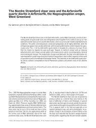
The Jurassic succession on Hold with Hope is subdivided<br />
into shallow marine sandstones of the Pelion<br />
and Payer Dal Formations (Vardekløft Group) and lower<br />
shoreface – offshore transition heteroliths and offshore<br />
mudstones of the Bernbjerg Formation (Hall Bredning<br />
Group). The Pelion Formation includes the new Spath<br />
Plateau Member, which contains abundant sandy heteroliths<br />
in contrast to the dominant clean sandstone lithology<br />
of the Pelion Formation. The sedimentary facies<br />
of the units are described and the depositional environments<br />
interpreted. The Jurassic succession is placed<br />
within a regional framework including the Wollaston<br />
Forland and Jameson Land Basins to the <strong>no</strong>rth and<br />
south, respectively.<br />
■■<br />
■■<br />
3<br />
■■■■<br />
■■ ■■<br />
Diener Bjerg<br />
Fig. 2. Geological map of part of <strong>no</strong>rthern Hold with Hope including position of localities mentioned in text. The composite section<br />
from Gulelv (Fig. 5) was compiled from five part-sections (A–E). The solid lines show schematically the orientation of the NE–SW<br />
and NW–SE log panels in Figures 7 and 8, respectively.<br />
<strong>GEUS</strong> <strong>Bulletin</strong> <strong>no</strong> <strong>5.pmd</strong> 53<br />
29-10-2004, 11:14<br />
■■ ■■<br />
■■<br />
■■<br />
■■ ■■<br />
■■ ■■<br />
■■<br />
■■ ■■<br />
Fosdalen<br />
■■<br />
■■<br />
■■ ■■ ■■<br />
Hold<br />
with<br />
Hope<br />
53