GEUS Bulletin no 5.pmd
GEUS Bulletin no 5.pmd
GEUS Bulletin no 5.pmd

You also want an ePaper? Increase the reach of your titles
YUMPU automatically turns print PDFs into web optimized ePapers that Google loves.
76<br />
75<br />
A new Middle–Upper Jurassic succession, up to 360 m<br />
thick, was found recently on <strong>no</strong>rthern Hold with Hope,<br />
North-East Greenland (Fig. 1; Stemmerik et al. 1997;<br />
Kelly et al. 1998; Larsen et al. 1998). It spans the Early<br />
Callovian – Early Kimmeridgian time interval as indicated<br />
by di<strong>no</strong>flagellate cysts and ammonites, and consists<br />
of coarse-grained sandstones overlain by heteroliths<br />
and mudstones. The sandstone-dominated lower<br />
part of the succession assigned here to the Pelion Formation<br />
was originally studied by Koch (1932) and<br />
Maync (1949) and was tentatively given an Early Cre-<br />
52<br />
Greenland<br />
28<br />
Milne<br />
Land<br />
24ºW<br />
PDMF<br />
Jameson<br />
Land<br />
DCF<br />
Traill Ø<br />
20ºW 16ºW<br />
Kuhn Ø<br />
Store<br />
Koldewey<br />
Wollaston<br />
Forland<br />
Clavering Ø<br />
Fig. 2<br />
Hold with Hope<br />
Geographical Society Ø<br />
DCF<br />
PDMF<br />
76ºN<br />
74ºN<br />
72ºN<br />
Jurassic<br />
Fault<br />
Dombjerg–Clavering Fault<br />
Post-Devonian Main Fault<br />
100 km<br />
<strong>GEUS</strong> <strong>Bulletin</strong> <strong>no</strong> <strong>5.pmd</strong> 52<br />
29-10-2004, 11:14<br />
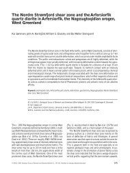
Fig. 1. Map of East Greenland showing<br />
the distribution of Jurassic sediments<br />
and major faults. Rectangle marks the<br />
investigated area on <strong>no</strong>rthern Hold with<br />
Hope, shown in more detail in Figure 2.<br />
Modified from Koch & Haller (1971)<br />
and Surlyk et al. (1973).<br />
taceous age, although W. Maync <strong>no</strong>ted the resemblance<br />
to the Middle Jurassic succession on Wollaston Forland.<br />
The apparent absence of Jurassic sediments in the<br />
Hold with Hope area was explained differently by<br />
Maync (1947), Do<strong>no</strong>van (1957), Surlyk (1977) and Stemmerik<br />
et al. (1993). Maync (1947) and Surlyk (1977)<br />
suggested that during the Jurassic the area formed a<br />
landmass between the Wollaston Forland Basin to the<br />
<strong>no</strong>rth and the Jameson Land Basin to the south, implying<br />
that the lack of sediments was primarily due to<br />
<strong>no</strong>n-deposition. Do<strong>no</strong>van (1957) in contrary found it