GEUS Bulletin no 5.pmd
GEUS Bulletin no 5.pmd
GEUS Bulletin no 5.pmd

Create successful ePaper yourself
Turn your PDF publications into a flip-book with our unique Google optimized e-Paper software.
ment of the active channels, which in a relatively short<br />
time shifted to a position farther away.<br />
Floodplains in braided river systems are <strong>no</strong>t commonly<br />
described in the literature, but studies by<br />
Reinfelds & Nanson (1993) of the Waimakariri River,<br />
New Zealand, show that braided rivers, contrary to the<br />
common conception, may include large areas of finegrained<br />
floodplains. During avulsion events, extensive<br />
wetland areas were established and contributed greatly<br />
to trapping and deposition of large volumes of finegrained<br />
material (e.g. Smith et al. 1989). A similar situation<br />
may have occurred at least twice during the lifetime<br />
of the Bristol Elv Formation river system, as shown<br />
by the occurrence of 3–6 m thick floodplain mudrocks<br />
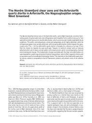
in the section on the south coast of Traill Ø (Figs 1, 6).<br />
The presence of root horizons and thin coal beds shows<br />
that the floodplain was densely vegetated and developed<br />
into peat swamps, before the river channel migrated<br />
back over the area and peat formation ceased.<br />
Fine-grained sediment present in the middle part of<br />
26<br />
W E<br />
20 m<br />
Fig. 6. Fluvial, floodplain and lacustrine deposits on the south coast of Traill Ø (Locality 1). Note the 20 m thick sandstone body in<br />
the centre (see Fig. 3, 134–153 m in log) showing down-stream or lateral accretion structures (dashed lines) with bedforms dipping<br />
gently to the right (east). The sandstone body overlies dark floodplain mudstones. Type section of the Bristol Elv Formation.<br />
<strong>GEUS</strong> <strong>Bulletin</strong> <strong>no</strong> <strong>5.pmd</strong> 26<br />
29-10-2004, 11:14<br />
the type section in Svinhufvud Bjerge is interpreted to<br />
have been deposited in a lacustrine/backswamp environment.<br />
Fine-grained sandstones intercalated with<br />
black and dark grey mudstone in the lower part of this<br />
lacustrine/backswamp unit show swaley cross-stratification<br />
and wave ripple cross-lamination associated with<br />
a pebble lag (Figs 3, 7). Swaley cross-stratification is<br />
interpreted as the result of storm-wave deposition above<br />
fairweather wave base and has been described from<br />
very shallow depths in the large Lake Superior (Greenwood<br />
& Sherman 1986; Sherman & Greenwood 1989).<br />
The wave ripple cross-lamination shows that some vigorous<br />
agitation must have occurred, probably during<br />
storm events (e.g. Allen 1982). The structures and the<br />
associated pebble lag are probably the result of shoreface<br />
erosion during storms, and subsequent transport<br />
into deeper waters by storm-induced currents (cf. Dam<br />
& Surlyk 1992, 1993). In the uppermost part of the<br />
lacustrine succession, the occurrence of a unit that<br />
shows coarsening-upwards from mudstone to very fine-