GEUS Bulletin no 5.pmd
GEUS Bulletin no 5.pmd
GEUS Bulletin no 5.pmd

Create successful ePaper yourself
Turn your PDF publications into a flip-book with our unique Google optimized e-Paper software.
the Pelion Formation. The mudstone–sandstone boundary<br />
in parasequence set 6 is characteristically sharp<br />
and is well suited as a lithostratigraphic boundary. The<br />
mudstone of the lower part of parasequence set 7 forms<br />
the top tongue of the Fossilbjerget Formation (Alsen &<br />
Surlyk 2004, this volume). The Olympen Formation<br />
comprises the sandstone-dominated upper part of parasequence<br />
set 7 and parasequence set 8 (Fig. 3).<br />
The ages of the three formations, as here defined,<br />
fit well with other areas in East Greenland. The base<br />
of the Pelion Formation is <strong>no</strong>t exposed or has <strong>no</strong>t<br />
yielded any fossils but is thought to belong to the Upper<br />
Bajocian Cadoceras borealis Chro<strong>no</strong>zone, in agreement<br />
with evidence from nearby areas in central Traill Ø.<br />
Parasequence sets 4 and 5 from the upper part of the<br />
formation belong to the C. pompeckji and C. apertum<br />
Chro<strong>no</strong>zones, and the top of the formation (Parnas<br />
Member) falls in the basal part of the C. <strong>no</strong>rdenskjoeldi<br />
Chro<strong>no</strong>zone (Fig. 3). The lower wedge of the Fossilbjerget<br />
Formation is only 25 m thick and belongs to<br />
the C. apertum Chro<strong>no</strong>zone. The age of the top wedge<br />
of the Fossilbjerget Formation (base of parasequence<br />
set 7) is poorly constrained but is probably still<br />
Callovian. This development is similar to that found in<br />
nearby Bjørnedal (Alsen & Surlyk 2004, this volume)<br />
and in central Jameson Land (Engkilde & Surlyk 2003).<br />
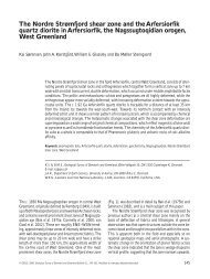
Palaeogeographic implications<br />
The south-eastwards down-dip palaeocurrent directions<br />
and proximal to distal facies changes of the Jurassic<br />
succession on the Bjørnedal Block indicate that the<br />
sea was open and deepest towards the east (Fig. 6).<br />
This contrasts with the adjacent parts of the Middle<br />
Jurassic basin of East Greenland which are characterised<br />
by N–S-oriented marine embayments limited to<br />
the east by elongated peninsulas, islands or submarine<br />
shoals formed by uplifted crests of westwardstilted<br />
blocks. These embayments were open and deepest<br />
towards the south as shown by overall southwardsdirected<br />
palaeocurrents and decrease in grain size<br />
(Surlyk 1977b, 1978, 2003; Surlyk & Clemmensen 1983).<br />
Conclusions<br />
The Bjørnedal Block was formed during rifting initiated<br />
in Late Bajocian time (Carr 1998). The block is<br />
bounded to the west by the west-dipping Vælddal Fault<br />
and is tilted towards the east in contrast to the Middle–<br />
28°W<br />
Land<br />
Sandstone with<br />
conglomerate<br />
Sandstone<br />
Sandstone and<br />
sandy mudstone<br />
Silty mudstone<br />
<strong>GEUS</strong> <strong>Bulletin</strong> <strong>no</strong> <strong>5.pmd</strong> 17<br />
29-10-2004, 11:14<br />
24°W<br />
20°W<br />
Traill Ø<br />
50 km<br />
73°N<br />
Geographical<br />
Society Ø<br />
Jameson<br />
Land<br />
Inferred coastline<br />
Hypothetical<br />
coastline<br />
Main direction of<br />
sediment transport<br />
Vælddal Fault<br />
72°N<br />
71°N<br />
Fig. 6. Generalised Bathonian (Middle Jurassic) palaeogeography<br />
and facies distribution in the Geographical Society Ø, Traill<br />
Ø and Jameson Land region. The sea was open towards east in<br />
the area comprising south-eastern Traill Ø and <strong>no</strong>rth-eastern<br />
Jameson Land due to the east-dipping nature of the more than<br />
30 km wide Bjørnedal Block, which was formed during early<br />
rifting. This contrasts with the remaining parts of the Jurassic<br />
basin of East Greenland where N–S-oriented marine embayments<br />
were limited to the east by elongated peninsulas, islands or<br />
submarine shoals formed by uplifted crests of westwards-tilted<br />
blocks. Based on Surlyk (1977b).<br />
Late Jurassic west-dipping blocks characterising the rest<br />
of the Jurassic basin of East Greenland. The Middle –<br />
lower Upper Jurassic succession in East Greenland<br />
shows mainly axial, southwards-directed palaeocurrents<br />
and sediment entered the basins at the head of faultcontrolled<br />
embayments. The succession on the<br />
Bjørnedal Block differs in showing east- and southeast-directed<br />
palaeocurrents and associated proximal<br />
17