GEUS Bulletin no 5.pmd
GEUS Bulletin no 5.pmd
GEUS Bulletin no 5.pmd

Create successful ePaper yourself
Turn your PDF publications into a flip-book with our unique Google optimized e-Paper software.
NW SE<br />
m<br />
1000<br />
500<br />
0<br />
NW SE<br />
m<br />
1000<br />
500<br />
0<br />
Månedal<br />
Fault zone<br />
Bordbjerg Fault<br />
Månedal Fault<br />
Syenitic plutons<br />
Basaltic sills<br />
Cretaceous<br />
progressively backstepped during the Bathonian and<br />
was eventually drowned in the Late Callovian due to<br />
increased rates of extension and a long-term eustatic<br />
rise in sea level (Engkilde & Surlyk 2003; Surlyk 2003).<br />
An exception to this simple pattern is found in southeastern<br />
Traill Ø, where an east-dipping fault block,<br />
more than 30 km wide, was formed during early rifting<br />
(Figs 1, 2; Carr 1998). It was limited to the west by the<br />
west-dipping Vælddal Fault (Do<strong>no</strong>van 1953; Carr 1998).<br />
The block, which is here termed the Bjørnedal Block,<br />
South coast, Traill Ø (Section A)<br />
Vælddal<br />
Vælddal Fault<br />
Steenstrup Dal<br />
Forchhammer Dal<br />
Rold Bjerge – Mols Bjerge (Section B)<br />
Upper Jurassic<br />
Middle Jurassic<br />
Triassic<br />
?<br />
Bjørnedal Block<br />
Upper Permian<br />
Carboniferous<br />
Drømmebugten<br />
Mols Bjerge Fault<br />
Fault, arrows indicate<br />
direction of movement<br />
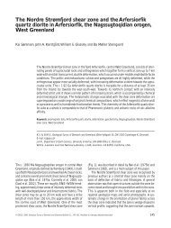
Fig. 2. NW–SE-oriented cross-sections showing the geological structure of eastern Traill Ø. Note the west-dipping Vælddal Fault,<br />
which forms the western limit of the Bjørnedal Block. Virtually all other Mesozoic faults in East Greenland dip towards the east and<br />
delimit westwards-tilted blocks. The positions of the sections are indicated on Fig. 1. Based on Koch & Haller (1971).<br />
Facing page:<br />
Fig. 1. Map of Traill Ø area showing the main faults and outcrops<br />
of the Jurassic succession. Positions of the structural<br />
cross sections (A, B) on Fig. 2 are indicated. Inset map (B)<br />
shows location of measured sedimentological sections (1–5).<br />
<strong>GEUS</strong> <strong>Bulletin</strong> <strong>no</strong> <strong>5.pmd</strong> 11<br />
29-10-2004, 11:14<br />
?<br />
Forårsdal<br />
5 km<br />
probably continues southwards into <strong>no</strong>rthern Jameson<br />
Land where poorly exposed east-dipping correlative<br />
strata occur on the south side of Kong Oscar Fjord<br />
(Fig. 1).<br />
The aim of this study is to compare and contrast the<br />
syn-rift Middle–Late Jurassic stratigraphic syn-rift development<br />
on the eastwards-dipping Bjørnedal Block<br />
on south-east Traill Ø with the rest of the Jurassic basin<br />
of East Greenland, which is characterised by westwards-tilted<br />
blocks.<br />
11