- Page 1 and 2:
ANNUAL DANISH INFORMATIVE INVENTORY
- Page 3 and 4:
AU ANNUAL DANISH INFORMATIVE INVENT
- Page 5 and 6:
$POUFOUT "DLOPXMFEHFNFOUT 4VNNBSZ *
- Page 7 and 8:
1SPKFDUJPOT "HSJDVMUVSF 8BTUF 3FGFS
- Page 9:
à à à à à à à à à à à Ã
- Page 12 and 13:
4VNNBSZ * #BDLHSPVOE JOGPSNBUJPO PO
- Page 14 and 15:
0UIFS BJS QPMMVUBOUT /PO NFUIBOF WP
- Page 16 and 17:
Wood combustion in residential plan
- Page 18 and 19:
to an error F28 was previously used
- Page 20 and 21:
eduction in emission of about 50 %
- Page 22 and 23:
elative bidrag for SO2, NOx og NH3
- Page 24 and 25:
holdningsanlæg (78 % i 2010). Emis
- Page 26 and 27:
tige syn i 2008. Opdaterede oplysni
- Page 28 and 29:
*OUSPEVDUJPO #BDLHSPVOE JOGPSNBUJPO
- Page 30 and 31:
QA/QC plan (Chapter 1.5), the data
- Page 32 and 33:
#SJFG EFTDSJQUJPO PG NFUIPEPMPHJFT
- Page 34 and 35:
of round trips per ferry, engine si
- Page 36 and 37:
sion. Simple mass balances for calc
- Page 38 and 39:
The Other Waste category includes c
- Page 40 and 41:
à *OEVTUSJBM QSPDFTTFT Categories
- Page 42 and 43:
Nielsen, O.-K., Mikkelsen, M.H., Ho
- Page 44 and 45:
42 Figure 2.1 Emissions of NH3, NOX
- Page 46 and 47:
44 Figure 2.4 NH3 emissions. Distri
- Page 48 and 49:
46 Figure 2.8 PM2.5 emissions. Dist
- Page 50 and 51:
48 Figure 2.11 Pb emissions. Time s
- Page 52 and 53:
&OFSHZ /'3 TFDUPS 0WFSWJFX PG UIF T
- Page 54 and 55:
Table 3.2 SO2, NOx, NMVOC, CO and P
- Page 56 and 57:
à ÃÃÃà 1A1c Manufacture of sol
- Page 58 and 59:
Fuel consumption, PJ Fuel consumpti
- Page 60 and 61:
creased 6 % since 2009. The biomass
- Page 62 and 63:
&NJTTJPOT 40 Stationary combustion
- Page 64 and 65:
emission from electricity and heat
- Page 66 and 67:
NMVOC, Gg 25 20 15 10 5 0 1985 1986
- Page 68 and 69:
accounting for 94 % of the PM2.5 em
- Page 70 and 71:
PM, Gg PM 2.5, Gg 30 25 20 15 10 5
- Page 72 and 73:
ÃÃÃÃÃÃÃÃÃÃ Ã ÃÃÃÆÃ
- Page 74 and 75:
à à 1") Stationary combustion pla
- Page 76 and 77:
à à à à %JPYJO Stationary combu
- Page 78 and 79:
à ÃÃÃÃÃÃÃÃÃà à Ãà Ã
- Page 80 and 81:
200 180 Ã 160 140 120 100 80 60
- Page 82 and 83:
à 0.025 0.020 à 0.015 à 0.010
- Page 84 and 85:
à à 25 20 à à 15 10 Ã
- Page 86 and 87:
The total fuel consumption in indus
- Page 88 and 89:
0.4 Ã 0.3 Ã 0.2 0.1 Ã Ã
- Page 90 and 91:
0.035 0.030 0.025 Ã 0.020 Ã 0.0
- Page 92 and 93:
à 0.30 à à 0.25 0.20
- Page 94 and 95:
à 6 à à 5 4 3 Ã
- Page 96 and 97:
à 60 à à 50 40 30 Ã
- Page 98 and 99:
14 12 Ã 10 8 6 4 2 0 10
- Page 100 and 101:
6 5 4 Ã Ã 3 2 É 1 0 6
- Page 102 and 103:
120 Ã 100 80 60 Ã 40
- Page 104 and 105:
16 Ã 14 12 10 8 Ã 6
- Page 106 and 107:
• Emission data reported from ind
- Page 108 and 109:
Due to the scarce data available an
- Page 110 and 111:
• Research carried out by TNO (Be
- Page 112 and 113:
à ÃÃÃÃÃÃÃÃÃÃà à à Ã
- Page 114 and 115:
Christiansen, B.H., Evald, A., Baad
- Page 116 and 117:
Danish Environmental Protection Age
- Page 118 and 119:
5SBOTQPSU BOE PUIFS NPCJMF TPVSDFT
- Page 120 and 121:
à 160 140 120 100 80 60 40 20 0
- Page 122 and 123:
à à Gasoline PC 36% Gasoline LDV
- Page 124 and 125:
3- 5 4,5 4 3,5 3 2,5 2 1,5 1 0,5 0
- Page 126 and 127:
à à ÃÃÃÃÃÃÃÃÃÃÃÃÃÃ
- Page 128 and 129:
7RQQHV 600000 500000 400000 300000
- Page 130 and 131:
à 7RQQHV 8000 7000 6000 5000 4000
- Page 132 and 133:
à à à à ment in emission factor
- Page 134 and 135:
à à ÃÃÃÃÃÃÃÃÃÃÃÃÃÃ
- Page 136 and 137:
ÃÉÃ ÃÉÃ Passenger cars 69% 2-
- Page 138 and 139:
à à à à 7RQQHV 250000 200000 15
- Page 140 and 141:
à à à Residential (1A4b) 2% Rail
- Page 142 and 143:
à à 763 HPLVVLRQV LQWHUQDWLRQDO E
- Page 144 and 145:
à 1200 1000 à 800 à 600 Ã
- Page 146 and 147:
à 2000 1600 à à 1200 à 800
- Page 148 and 149:
à ÃÃÃÃÃÃÃÃÃÃÃÃÃÃÃ
- Page 150 and 151:
For all vehicle categories/technolo
- Page 152 and 153:
For catalyst vehicles the cold extr
- Page 154 and 155:
à '($ 1(5, IXHO UDWLR 1,30 1,25 1,
- Page 156 and 157:
(EMEP/EEA, 2009) for air traffic, o
- Page 158 and 159:
Agricultural tractors (diesel) < 80
- Page 160 and 161:
à Ãà No. 12000 10000 8000 6000 4
- Page 162 and 163:
à ÃÃÃÉÃÃà The 1985-2010 sto
- Page 164 and 165:
Ã
- Page 166 and 167:
à 1R RI URXQG WULSV 1R RI URXQG WU
- Page 168 and 169:
à &NJTTJPO MFHJTMBUJPO For non-roa
- Page 170 and 171:
total emissions (in grams) from the
- Page 172 and 173:
à Further, the Marine Environment
- Page 174 and 175:
European measurement programmes; se
- Page 176 and 177:
Where FC = fuel consumption (kg), m
- Page 178 and 179:
Where EEvap,fueling, = hydrocarbon
- Page 180 and 181:
For gasoline, the DEA residential s
- Page 182 and 183:
The time series of emissions for mo
- Page 184 and 185:
ICAO Annex 16: "International stand
- Page 186 and 187:
Wismann, T. 2001: Energiforbrug og
- Page 188 and 189:
ÃÃÃÃÃÃÃÃÃÃÃÃÃÃÃÃ Ã
- Page 190 and 191:
à à à à à à à à à Éà Ã
- Page 192 and 193:
where EMFreloading is the emission
- Page 194 and 195:
à Number of platforms 60 50 40 30
- Page 196 and 197:
ÃÃÃÃÃÃÃÃÃÃÃÃÃÃÃÃÃ
- Page 198 and 199:
Flaring in gas treatment and storag
- Page 200 and 201:
à ÃÃÃÃÃÃÃÃÃÃÃÃà Ã
- Page 202 and 203:
à à ÃÃÃÃÃÃÃÃà à à Ã
- Page 204 and 205:
à à ÃÃÃÃÃÃÃÃÃÃÃÃÃÃ
- Page 206 and 207:
à ÃÃÃÃÃÃÃÃà à Ã
- Page 208 and 209:
• Check of units for fuel rate, e
- Page 210 and 211:
4PVSDF TQFDJGJD SFDBMDVMBUJPOT In t
- Page 212 and 213:
Fenhann, J. & Kilde, N.A. 1994: Inv
- Page 214 and 215:
ÃÃÃÃÃÃÃÃÃÃÃÃÃÃÃÃÃ
- Page 216 and 217:
à ÃÃÃÃÃÃÃÃÃÃÃÃÉÃÃÃ
- Page 218 and 219:
à 4PVSDF TQFDJGJD SFDBMDVMBUJPOT P
- Page 220 and 221:
emission factor based on 2000 figur
- Page 222 and 223:
Danish Foundries. The emission of T
- Page 224 and 225:
à FUIPEPMPHJDBM JTTVFT The emissio
- Page 226 and 227:
à 0UIFS QSPEVDUJPO DPOTVNQUJPO TUP
- Page 228 and 229:
IPCC, 1997: Revised 1996 IPCC Guide
- Page 230 and 231:
228 Emission modelling of solvents
- Page 232 and 233:
230 ends in waste water, e.g. ethan
- Page 234 and 235:
à à à à 232 ÃÃÃÃÃÃÃÃÃ
- Page 236 and 237:
234 ÃÃÃÃÃÃÃÃÃ Ã ÃÃ ÃÃ
- Page 238 and 239:
ÃÃÃÃÃÃÃÃÃÃÃ Ã Ã Ã Ã
- Page 240 and 241:
238 confidentiality or that the amo
- Page 242 and 243:
240 • Inclusion of NMVOC use and
- Page 244 and 245:
242 Oertzen, Bundesanstalt für Mat
- Page 246 and 247:
"HSJDVMUVSF /'3 TFDUPS 0WFSWJFX PG
- Page 248 and 249:
only 18 % and 5 % respectively. Mos
- Page 250 and 251:
DCE - the Danish Centre for Environ
- Page 252 and 253:
à 100 90 80 70 60 50 40 30 20 10
- Page 254 and 255:
ÃÃÃÃÃÃÃÃÃÃÃÃÃÃÃÃÃ
- Page 256 and 257:
à The implied emission factors rel
- Page 258 and 259:
à In 2010 the PM emission from hou
- Page 260 and 261:
ÃÃÃÃÃÃÃÃÃÃÃÃÃ Ã Ã Ã
- Page 262 and 263: EEA guidebook (EMEP/EEA, 2009) defa
- Page 264 and 265: ased on EMEP/EEA guidebook. All unc
- Page 266 and 267: The emission of NMVOC from crops ha
- Page 268 and 269: Ã 8BTUF /'3 TFDUPS The waste secto
- Page 270 and 271: Ã ÃÃÃÃÃÃÃÃÃ ÃÃÃÆÃÃ
- Page 272 and 273: Ã sions is based on emission facto
- Page 274 and 275: ÃÃÃÃÃÃÃÃÃÃÃ Ã
- Page 276 and 277: Ã Ã ity from these facilities. Th
- Page 278 and 279: Ã ÃÃÃÃÃÃÃÃÃÃÃÃ Ã Ã
- Page 280 and 281: 0UIFS XBTUF This category is a catc
- Page 282 and 283: Ã Ã Petersen (2001) and Petersen
- Page 284 and 285: Ã ÃÃÃÃÃÃÃÃÃÃ ÃÃ Ã
- Page 286 and 287: Ã describes the average share of b
- Page 288 and 289: Ã ÃÃÃÃÃÃÃÃ Ã Ã Ã Ã Ã
- Page 290 and 291: Ã The last three sources that were
- Page 292 and 293: Ã FUIPEPMPHZ Emissions from vehicl
- Page 294 and 295: Ã Ã ÃÃÃÃÃÃÃÃÃÃÃÃÃÃ
- Page 296 and 297: Ã &NJTTJPO GBDUPST In the process
- Page 298 and 299: ÃÃÃÃÃÃÃÃ Ã Ã Ã Ã
- Page 300 and 301: Ã ÃÃÃÃÃÃÃÃÃÃÆÃ Ã
- Page 302 and 303: Ã ÃÃÃÃÃÃÃÃÃ Ã ÃÃ ÃÃ
- Page 304 and 305: http://www2.mst.dk/udgiv/publikatio
- Page 306 and 307: Lemieux, P.M., Lutes, C.C. & Santoi
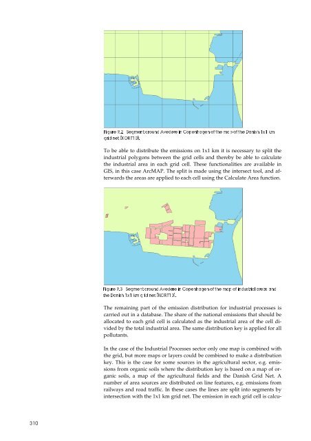
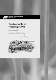
- Page 308 and 309: 0UIFS BOE OBUVSBM FNJTTJPOT Denmark
- Page 310 and 311: http://cdr.eionet.europa.eu/dk/Air_
- Page 314 and 315: ÃÃÃÃÃÃÃÃÃÃÃÃÃ ÃÃ Ã
- Page 316 and 317: 0 Ã The major GNFR source to NOx e
- Page 318 and 319: 3FDBMDVMBUJPOT BOE *NQSPWFNFOUT In
- Page 320 and 321: craft which cannot represent these
- Page 322 and 323: too high. The addition of the categ
- Page 324 and 325: "OOFY ,FZ DBUFHPSZ BOBMZTJT Due to
- Page 326 and 327: "OOFY " $PSSFTQPOEFODF MJTU GPS 4/"
- Page 328 and 329: Ã ÃÃÃÃÃÉÃ ÃÃ Ã Ã ÃÃÃ
- Page 330 and 331: ÃÃ ÃÃÃ Ã Ã Ã Ã Ã Ã Ã Ã
- Page 332 and 333: Ã Ã Ã Ã Ã Ã Ã Ã Ã Ã Ã Ã
- Page 334 and 335: Ã Ã Ã Ã Ã Ã Ã Ã Ã Ã Ã Ã
- Page 336 and 337: Ã Ã Ã Ã Ã Ã Ã Ã Ã Ã Ã Ã
- Page 338 and 339: Ã Ã Ã Ã Ã Ã Ã Ã Ã Ã Ã Ã
- Page 340 and 341: Ã Ã Ã Ã Ã Ã Ã Ã Ã Ã Ã Ã
- Page 342 and 343: Ã Ã Ã Ã Ã Ã Ã Ã Ã Ã Ã Ã
- Page 344 and 345: Ã Ã Ã Ã Ã Ã Ã Ã Ã Ã Ã Ã
- Page 346 and 347: Ã Ã Ã Ã ÃÃ Ã Ã Ã Ã Ã Ã
- Page 348 and 349: Ã Ã Ã Ã ÃÃ Ã Ã Ã Ã Ã Ã
- Page 350 and 351: "OOFY " %FGBVMU -PXFS $BMPSJGJD 7BM
- Page 352 and 353: ÃÃ ÃÃÃ Ã Ã Ã Ã Ã Ã Ã Ã
- Page 354 and 355: "OOFY " &NJTTJPO GBDUPST ÃÃÃÃ
- Page 356 and 357: Ã ÃÃ ÃÃ ÃÃ Ã Ã Ã Ã Ã
- Page 358 and 359: ÃÃÃÃÃÃÃÃÃÆÃÉÃÃÃÃÃ
- Page 360 and 361: Ã Ã Ã Ã Ã Ã Ã Ã Ã Ã Ã Ã
- Page 362 and 363:
à à à à à à à à à à à Ã
- Page 364 and 365:
à à à à à à à à à à à Ã
- Page 366 and 367:
à à à à à à à à à à à Ã
- Page 368 and 369:
à à à à à à à à à à à Ã
- Page 370 and 371:
à à à à à à à à à à à Ã
- Page 372 and 373:
à à à à à à à à à à à Ã
- Page 374 and 375:
ÃÃ ÃÃ ÃÃ ÃÃ Ã Ã Ã Ã Ã
- Page 376 and 377:
ÃÃÃÃÃÃÃÃÃÃÃÃÃÃ Ã Ã
- Page 378 and 379:
ÃÃÃÃÃÃÃÃÃÃÃÃÃÃ Ã Ã
- Page 380 and 381:
ÃÃÃÃÃÃÃÉÃÃÃÃÃÃ Ã Ã
- Page 382 and 383:
à à à à à à à à à à à Ã
- Page 384 and 385:
à à à à à à à à à à à Ã
- Page 386 and 387:
à à à à à à à à à à à Ã
- Page 388 and 389:
à à à à à à à à à à à Ã
- Page 390 and 391:
à à à à à à à à à à à Ã
- Page 392 and 393:
à à à à à à à à à à à Ã
- Page 394 and 395:
Ã Ã Ã Ã Ã É Ã Ã É Ã Ã É
- Page 396 and 397:
ÃÃÃÃÃÃÃÃÃÃÃÃÃÃÃÃÃ
- Page 398 and 399:
ÃÃÃÃÃÃÃÃÃÃÃÃÃÃÃÃÃ
- Page 400 and 401:
ÃÃÃÃÃÃÃÃÃÃ Ã Ã Ã Ã Ã
- Page 402 and 403:
ÃÃÃÃÃÃÃÃÃÃÃÃÃÃÃÃ Ã
- Page 404 and 405:
ÃÃÃÃÃÃÃÃ ÃÃ ÃÃ ÃÃ Ã
- Page 406 and 407:
"OOFY " -BSHF QPJOU TPVSDFT ÃÃÃ
- Page 408 and 409:
à à à Ãà à Ãà à à à ÃÃ
- Page 410 and 411:
à à Ãà à à à à à à à Ã
- Page 412 and 413:
"OOFY " 6ODFSUBJOUZ FTUJNBUFT ÃÃ
- Page 414 and 415:
à à ÃÃà ÃÃà à à à à Ã
- Page 416 and 417:
à à ÃÃà ÃÃà à à à à Ã
- Page 418 and 419:
à à ÃÃà ÃÃà à à à à Ã
- Page 420 and 421:
à à ÃÃà ÃÃà à à à à Ã
- Page 422 and 423:
à à à à à à ÃÃà ÃÃà Ã
- Page 424 and 425:
à Ãà à à à à à à Ãà Ã
- Page 426 and 427:
"OOFY " %FTDSJQUJPO PG UIF %BOJTI F
- Page 428 and 429:
ÃÃÃÃÃÃÃÃÃÃÃÃÃÃÃÉÃ
- Page 430 and 431:
ÃÃ Ã Ã Ã Ã Ã Ã Ã ÃÉÃÃ
- Page 432 and 433:
ÃÃ Ã Ã Ã Ã Ã Ã Ã ÃÉÃÃ
- Page 434 and 435:
NMVOC, Gg CO, Gg 25 20 15 10 5 0 18
- Page 436 and 437:
ÃÃ ÃÃ Ã ÃÃÃÃÃÃ ÃÃ ÃÃ
- Page 438 and 439:
ÃÃ Ã Ã ÃÃÃÃÃÃÃ ÃÃ ÃÃ
- Page 440 and 441:
à à Ãà à à Ãà à à Ãà Ã
- Page 442 and 443:
440 "OOFY # 5SBOTQPSU -JTU PG DPOUF
- Page 444 and 445:
442 ÃÃ ÃÃÃ ÃÃ Ã Ã Ã Ã Ã
- Page 446 and 447:
444 ÃÃÃ ÃÃÃÃÃ ÃÃ Ã Ã Ã
- Page 448 and 449:
446 Ã Ã ÃÃ Ã Ã Ã Ã Ã Ã Ã
- Page 450 and 451:
448 ÃÃÃ ÃÃÃÃÃÃ ÃÃ Ã Ã
- Page 452 and 453:
450 Ã ÃÃÃ ÃÃ Ã Ã Ã Ã Ã
- Page 454 and 455:
452 ÃÃ ÃÃÃ ÃÃ Ã Ã Ã Ã Ã
- Page 456 and 457:
454 ÃÃÃ ÃÃÃ ÃÃ Ã Ã Ã Ã
- Page 458 and 459:
456 Ã ÃÃÃ ÃÃ Ã Ã Ã Ã Ã
- Page 460 and 461:
458 ÃÃÃ ÃÃÃÃÃ ÃÃ Ã Ã Ã
- Page 462 and 463:
460 Ã ÃÃÃÃ Ã Ã Ã Ã Ã Ã
- Page 464 and 465:
462 "OOFY # &6 EJSFDUJWF FNJTTJPO M
- Page 466 and 467:
"OOFY # #BTJT FNJTTJPO GBDUPST H QS
- Page 468 and 469:
ÃÃÃ ÃÃÃÃÃ ÃÃ Ã Ã
- Page 470 and 471:
à Ãà à à à à Ã
- Page 472 and 473:
ÃÃ ÃÃÃ ÃÃ Ã Ã
- Page 474 and 475:
ÃÃÃ ÃÃÃÃÃ ÃÃ Ã
- Page 476 and 477:
"OOFY # 3FEVDUJPO GBDUPST Ã Ã Ã
- Page 478 and 479:
ÃÃÃ ÃÃÃÃÃ ÃÃ Ã Ã Ã Ã
- Page 480 and 481:
à ÃÃÃà à à à à à à à Ã
- Page 482 and 483:
"OOFY # %FUFSJPSBUJPO GBDUPST Ã Ã
- Page 484 and 485:
"OOFY # 'VFM DPOTVNQUJPO GBDUPST +
- Page 486 and 487:
ÃÃÃ Ã Ã Ã Ã Ã Ã Ã Ã Ã
- Page 488 and 489:
à à à à à à à à à à à Ã
- Page 490 and 491:
ÃÃÃ Ã Ã Ã Ã Ã Ã Ã Ã Ã
- Page 492 and 493:
à à à à à à à à à à à Ã
- Page 494 and 495:
492 ÃÃÃ Ã Ã Ã Ã Ã Ã Ã Ã
- Page 496 and 497:
494 Ã Ã Ã Ã Ã Ã Ã Ã Ã Ã
- Page 498 and 499:
496 "OOFY # $01&35 *7 %&" TUBUJTUJD
- Page 500 and 501:
ÃÃÃÃÃÃÃÃ Ã Ã Ã ÃÃ ÃÃ
- Page 502 and 503:
500 ÃÃÃÃÃÃÃÃ ÃÃ ÃÃ Ã
- Page 504 and 505:
à à à à 502 ÃÃÃÃÃà à Ã
- Page 506 and 507:
504 ÃÃÃÃÃ ÃÃ ÃÃ Ã Ã Ã
- Page 508 and 509:
506 "OOFY # 4UPDL EBUB GPS OPO SPBE
- Page 510 and 511:
508 ÃÉÃ ÃÃ Ã Ã Ã Ã Ã Ã
- Page 512 and 513:
510 ÃÃÃÃÃÃ ÃÉÃ ÃÃ
- Page 514 and 515:
512 Ã Ã Ã Ã Ã Ã Ã ÃÃ ÃÃ
- Page 516 and 517:
514 Ã Ã ÃÃ Ã Ã Ã Ã Ã Ã
- Page 518 and 519:
516 ÃÃÃÉÃÃ Ã Ã Ã Ã Ã Ã
- Page 520 and 521:
518 ÃÃ Ã Ã Ã Ã Ã Ã Ã Ã Ã
- Page 522 and 523:
ÃÃÃÃÃÃÃ Ã ÃÉÃ ÃÃ Ã Ã
- Page 524 and 525:
à ÃÉà à à à à à à à Ã
- Page 526 and 527:
524 ÃÃÃÃÃÃÃÃÃ Ã Ã ÃÃ
- Page 528 and 529:
526 "OOFY # 5SBGGJD EBUB BOE EJGGFS
- Page 530 and 531:
528 Ã ÃÃ Ã Ã ÃÃÉÃ Ã Ã Ã
- Page 532 and 533:
à Ãà à à à à à à à à Ã
- Page 534 and 535:
à Ãà à à à à à à à à Ã
- Page 536 and 537:
ÃÃÃÃÃÉÆÃ ÃÃ ÃÃ Ã Ã Ã
- Page 538 and 539:
à à à à à à à à à à à Ã
- Page 540 and 541:
538 Ã ÃÃ ÃÃ ÃÃ ÃÃ ÃÃ Ã
- Page 542 and 543:
à à 540 à Ãà Ãà Ãà Ãà Ã
- Page 544 and 545:
542 Ã ÃÃ Ã Ã Ã Ã Ã Ã Ã Ã
- Page 546 and 547:
ÃÃÃ Ã Ã Ã Ã Ã Ã Ã Ã Ã
- Page 548 and 549:
546 Ã Ã Ã Ã Ã Ã Ã Ã Ã Ã
- Page 550 and 551:
548 ÃÃÃÃÃÃ Ã Ã Ã Ã Ã Ã
- Page 552 and 553:
550 Ã Ã Ã Ã Ã Ã Ã Ã Ã Ã
- Page 554 and 555:
552 Ã Ã Ã ÃÃ Ã Ã Ã Ã Ã Ã
- Page 556 and 557:
554 Ã Ã Ã ÃÃ Ã Ã Ã Ã Ã Ã
- Page 558 and 559:
à 556 à à à ÃÃà Ãà Ãà Ã
- Page 560 and 561:
558 Ã Ã Ã ÃÃÃÃÃÃ Ã Ã Ã
- Page 562 and 563:
560 Ã Ã Ã ÃÃÃÃÃÃ Ã Ã Ã
- Page 564 and 565:
562 Ã Ã Ã ÃÃ Ã Ã Ã Ã Ã Ã
- Page 566 and 567:
564 Ã Ã Ã ÃÃ Ã Ã Ã Ã Ã Ã
- Page 568 and 569:
566 Ã Ã Ã ÃÃ Ã Ã Ã Ã Ã Ã
- Page 570 and 571:
568 Ã Ã Ã ÃÃ Ã Ã Ã Ã Ã Ã
- Page 572 and 573:
570 Ã Ã Ã ÃÃ Ã Ã Ã Ã Ã Ã
- Page 574 and 575:
572 Ã Ã Ã ÃÃ Ã Ã Ã Ã Ã Ã
- Page 576 and 577:
à à à à à à à à à à Ã
- Page 578 and 579:
576 Ã Ã Ã Ã Ã Ã Ã Ã Ã Ã
- Page 580 and 581:
à ÃÃÉà à Ãà à à Ãà Ã
- Page 582 and 583:
à ÃÃÉÃà à Ãà à à Ãà Ã
- Page 584 and 585:
à ÃÃÉÃà à Ãà à à Ãà Ã
- Page 586 and 587:
à ÃÃÉ Ã Ã Ãà à à Ãà Ã
- Page 588 and 589:
à ÃÃÃÃÉà Ãà à Ãà à Ã
- Page 590 and 591:
à ÃÃÃÃÉà Ãà à Ãà à Ã
- Page 592 and 593:
ÉÃÃ ÃÃÉÃ Ã ÃÃ Ã Ã ÃÃ
- Page 594 and 595:
à ÃÃÉÃà à à ÃÃ
- Page 596 and 597:
à ÃÃÃà à à ÃÃÃ
- Page 598 and 599:
à ÃÃÃÇÃà à à Ã
- Page 600 and 601:
à ÃÃÃà à à ÃÃÃ
- Page 602 and 603:
à ÃÃÉÃà à à ÃÃ
- Page 604 and 605:
ÉÃÃ ÃÃÃÃ Ã ÉÃ
- Page 606 and 607:
ÉÃÃ ÃÃ Ã ÉÃÃ Ã
- Page 608 and 609:
ÃÃÃ Ã Ã Ã Ã Ã Ã
- Page 610 and 611:
ÃÃÃ Ã 608 Ã Ã Ã Ã
- Page 612 and 613:
ÃÃÃ Ã 610 Ã Ã Ã Ã
- Page 614 and 615:
ÃÃÃ Ã 612 Ã Ã Ã Ã
- Page 616 and 617:
ÃÃÉÃÃ Ã Ã Ã Ã Ã
- Page 618 and 619:
"OOFY $ "HSJDVMUVSF "OOFY $ #BDLHSP
- Page 620 and 621:
on information from the Danish Plan
- Page 622 and 623:
ÃÃÃÃÃÃÃÃÃÃ Ã Ã ÃÃ Ã
- Page 624 and 625:
à "OOFY $ #BDLHSPVOE JOGPSNBUJPO /
- Page 626 and 627:
3FGFSFODFT Andersen, J.M., Sommer,
- Page 628 and 629:
"OOFY % )VNBO DSFNBUJPO BDUJWJUZ EB
- Page 630 and 631:
"OOFY % &NJTTJPOT GSPN IVNBO DSFNBU
- Page 632 and 633:
ÃÃÃÃÃÃÃÃÃÃÃÃÃÃÃ ÃÃ
- Page 634 and 635:
"OOFY % &NJTTJPOT GSPN BOJNBM DSFNB
- Page 636 and 637:
ÃÃÃÃÃÃÃÃÃÃÃÃÃÃÃÃ Ã
- Page 638 and 639:
"OOFY % $PNQPTU QSPEVDUJPO BDUJWJUZ
- Page 640 and 641:
"OOFY % 0DDVSSFODF PG BMM GJSFT CVJ
- Page 642 and 643:
"OOFY % &NJTTJPO GBDUPST GPS BDDJEF
- Page 644 and 645:
"OOFY % &NJTTJPO GBDUPST GPS BDDJEF
- Page 646 and 647:
"OOFY % &NJTTJPO GBDUPST GPS BDDJEF
- Page 648 and 649:
"OOFY % "WFSBHF CVJMEJOH GMPPS TQBD
- Page 650 and 651:
ÃÃÃÃÃÃÃÃÃÃ Ã Ã
- Page 652 and 653:
ÃÃÃÃÃÃÃÃÃÃÃÃÃÃÃ Ã
- Page 654 and 655:
"OOFY % "WFSBHF WFIJDMF XFJHIU ÃÃ
- Page 656 and 657:
ÃÃÃÃÃÃÃÃÃÃÃÃ ÃÃ Ã Ã
- Page 658 and 659:
ÃÃÃÃÃÃÃÃÃÃÃÃÃ Ã Ã Ã
- Page 660 and 661:
"OOFY & /70$ FNJTTJPOT ÃÃÃÃÃÃ
- Page 662 and 663:
"OOFY & &NJTTJPOT GSPN VTF PG GJSFX
- Page 664 and 665:
ÃÃÃÃÃÃÃÃÃ Ã Ã Ã Ã
- Page 666 and 667:
"OOFY & &NJTTJPOT GSPN CBSCFRVJOH
- Page 668 and 669:
"OOFY & "DUJWJUZ EBUB GPS PUIFS QSP
- Page 670 and 671:
"HSJDVMUVSF NMVOC from animal husba
- Page 672:
ANNUAL DANISH INFORMATIVE INVENTORY