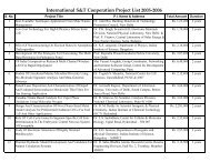
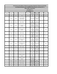
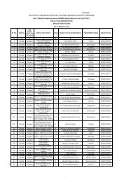
List of Projects Sanctioned for the year 2009 - Department of ...
List of Projects Sanctioned for the year 2009 - Department of ...
List of Projects Sanctioned for the year 2009 - Department of ...

Create successful ePaper yourself
Turn your PDF publications into a flip-book with our unique Google optimized e-Paper software.
<strong>List</strong> <strong>of</strong> <strong>Projects</strong> <strong>Sanctioned</strong> <strong>for</strong> <strong>the</strong> <strong>year</strong> <strong>2009</strong>-2010<br />
S.No Title <strong>for</strong> <strong>the</strong> project Name & Address <strong>of</strong><br />
PI<br />
1 Integration <strong>of</strong> Bio-geo data and<br />
modeling <strong>for</strong> run<strong>of</strong>f, soil loss, growth <strong>of</strong><br />
bio resources and effect <strong>of</strong> climate<br />
change<br />
2 An Operational Marine GIS Expert<br />
System <strong>for</strong> Mapping <strong>of</strong> Non-living<br />
Resources<br />
3 Geological Geo-morphological and<br />
Geotechnical Studies <strong>for</strong> Landslide<br />
Assessment along Ghat Road from 0<br />
Km <strong>of</strong> Kolli Hills, Tamil Nadu<br />
4 Management <strong>of</strong> Water logging and<br />
Salinity in Central Haryana using Geoin<strong>for</strong>matics<br />
5 Surveying and Mapping <strong>of</strong> <strong>the</strong><br />
Landslide Prone Area between Rampur<br />
to Jhakri along with <strong>the</strong> Highway NH -<br />
22 in H.P.<br />
6 Landslide Hazard Mitigation and<br />
Mapping Along Corridor <strong>of</strong> Road<br />
Section National Highway No. 109 from<br />
Rudraprayag to Kedarnath and Micro<br />
Zonation <strong>of</strong> <strong>the</strong> Region on GIS Plat<strong>for</strong>m<br />
using RS & GPS<br />
7 Application <strong>of</strong> Joint / 3D Fault<br />
De<strong>for</strong>meter in Predicting <strong>the</strong> Slope<br />
Failure along <strong>the</strong> Tectonically Active<br />
Churachandpur - Mao Thrust (CMT) in<br />
Manipur<br />
8 Landslide Risk Analysis <strong>of</strong> Road cut hill<br />
slopes near Mahabaleshwar, Along <strong>the</strong><br />
State Highway via Poladpur, Satara<br />
District, Maharashtra<br />
Pr<strong>of</strong>. S.C. Patra, North<br />
Eastern Regional<br />
Institute <strong>of</strong> Water and<br />
Land Management,<br />
Dolabari, PO<br />
Kaliabhomora , Tezpur<br />
– 784 027<br />
Dr. N. Chandrasekar,<br />
Centre <strong>for</strong> Geo<br />
Technology,<br />
Manonmaniam<br />
Sundaranar University,<br />
Tirunelveli<br />
Dr. S. Anbazhagan,<br />
Periyar University,<br />
Salem<br />
Dr. Ramesh.S. Hooda,<br />
Haryana Space<br />
Application Centre<br />
(HARSAC), CCS HAU<br />
Campus, Hissar<br />
Dr. G.S. Gill, Punjab<br />
University, Chandigarh<br />
Dr. Mohan Singh<br />
Panwar, HNB Garhwal<br />
University Central<br />
Campus, Garhwal<br />
Dr. Arun Kumar,<br />
Manipur University,<br />
Chanchipur, Imphal<br />
Pr<strong>of</strong>. T.N. Singh,<br />
Indian Institute <strong>of</strong><br />
Technology, Mumbai<br />
Amount Duration<br />
<strong>Sanctioned</strong><br />
( Rs. )<br />
34,52,100 5 Years<br />
16,97,975 3 Years<br />
11,63,000 2 Years<br />
24,90,000 3 Years<br />
17,21,000 2 Years<br />
11,26,000 2 Years<br />
12,00,000 2 Years<br />
39,73,200 3 Years
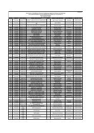
9 Comprehensive Geo-visualization <strong>of</strong><br />
water resource data pertaining to Vatrak<br />
sub watershed fo Sabarmati river basin,<br />
Sabarkantha District, Gujarat <strong>for</strong> multi<br />
purpose applications<br />
10 A Geotechnical Model <strong>for</strong> Landslide<br />
Remediation at Darjeeling Area using<br />
Soil Nails<br />
11 Topographical and Geological Mapping<br />
<strong>of</strong> Jalan Slide, Near Dadahu on Nahan-<br />
Renuka Road, Sirmour District H.P<br />
12 Modeling <strong>of</strong> Landslide Hazard Among<br />
Identified Zones <strong>of</strong> Sirumalai area <strong>of</strong><br />
Dindigul District, Tamilnadu using GI<br />
Technologies<br />
13 A Decision Support In<strong>for</strong>mation System<br />
<strong>for</strong> Water Resources Evaluation and<br />
Management in Narava and Pulivendula<br />
Micro Watershed in AP<br />
14 Development <strong>of</strong> Geo-visualization Tool<br />
<strong>for</strong> Ground Water Resource<br />
Management<br />
15 Development <strong>of</strong> North Eastern Spatial<br />
Data Infrastructure (NESDI)<br />
16 Geo-visualization <strong>of</strong> Landscape and elearning<br />
Course<br />
17 Streng<strong>the</strong>ning <strong>the</strong> Role <strong>of</strong> PRIs in Water<br />
Resources Inventory and Development<br />
Planning in Almora District,<br />
Uttarakhand<br />
18 Integrated Flood Assessment Modeling<br />
<strong>for</strong> Urban Watersheds Using Finite<br />
Element Method, GIS and Remote<br />
Sensing<br />
Dr. V.H. Patel,<br />
Bhaskaracharya<br />
Institute <strong>for</strong> Space<br />
Applications and Geoin<strong>for</strong>matics<br />
(BISAG),<br />
Gandhinagar<br />
Dr. Chittaranjan Patra,<br />
National Institute <strong>of</strong><br />
Technology, Rourkela<br />
Dr. Naval Kishore,<br />
Punjab University,<br />
Chandigarh<br />
Dr. G. Arivarignan,<br />
Madhurai Kamraj<br />
University, Madhurai<br />
Pr<strong>of</strong>. NVBSS Prasad,<br />
Andhra University,<br />
Visakhapatanam and<br />
SV University, Tirupati<br />
Dr. R.D. Garg, Indian<br />
Institute <strong>of</strong><br />
Technology, Roorkee<br />
Dr. S.C. Patra, North<br />
Eastern Regional<br />
Institute <strong>of</strong> Water and<br />
Land Management<br />
(NERIWALM),<br />
Tezpur, Assam<br />
Dr. Milap Punia,<br />
School <strong>of</strong> Social<br />
Sciences, Jawaharlal<br />
Nehru University, New<br />
Delhi<br />
Ms. M.S. Vani,<br />
Development Centre<br />
<strong>for</strong> Alternative Policies<br />
(DCAP), New Delhi<br />
Pr<strong>of</strong>. Eldho T.I, Indian<br />
Institute <strong>of</strong><br />
Technology, Bombay,<br />
Mumbai<br />
25,00,000 2 Years<br />
20,66,000 2 Years<br />
14,25,000 2 Years<br />
12,48,000 2 Years<br />
40,12,000 2 Years<br />
25,38,600 2 Years<br />
2,45,89,400 3 Years<br />
Contributio<br />
n <strong>of</strong> :<br />
DST<br />
2,10,89,400<br />
NEC :<br />
35,00,000<br />
38,84,000 3 Years<br />
71,90,000 3 Years<br />
40,46,760 3 Years
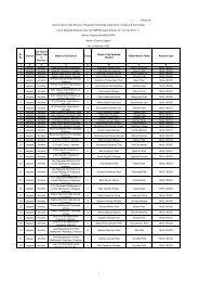
19 "Gender Atlas" Pr<strong>of</strong>. Saraswati Raju,<br />
School <strong>of</strong> Social<br />
Sciences, Jawaharlal<br />
Nehru University,<br />
New Delhi<br />
20 Setting up <strong>of</strong> Centre <strong>of</strong> Excellence <strong>for</strong><br />
NRDMS in Uttarakhand<br />
21 Two Days Workshop on Sensor<br />
Networks & Web Enablement<br />
22 Advanced Research Lab <strong>for</strong> Geospatial<br />
In<strong>for</strong>mation Science and Engineering<br />
23 Mapping <strong>of</strong> 1:10K scale using High<br />
Resolution Stereo Satellite Image – as<br />
pilot study in sheet No. 56N/1 by<br />
ARSRAC, Hyderabad<br />
24 Spatial Distribution <strong>of</strong> Genetic Diversity<br />
<strong>of</strong> Traditional Farmer's Varieties – A<br />
Pilot Study from Nagapattinam Distt<br />
Tamilnadu<br />
25 Integrated Hydrological Appraisal <strong>of</strong><br />
Dabka micro-watershed (Nainital) :<br />
Surface run<strong>of</strong>f and Spring Flow<br />
Modeling<br />
26 Restoration and Rehabliitation <strong>of</strong><br />
Tsunami affected eco-system through<br />
Alternate Livelihood involving<br />
Agriculture, Animal Husbandry and<br />
Fisheries - reg<br />
27 Development <strong>of</strong> LZH and study <strong>of</strong> slide<br />
zone and o<strong>the</strong>r problems <strong>the</strong>re<strong>of</strong> around<br />
Rawana Village, Raigarh Tehsil, Sirmur<br />
District, HP<br />
Pr<strong>of</strong>. J.S. Rawat,<br />
Kumaun University,<br />
Almora<br />
Pr<strong>of</strong>. Santanu<br />
Chaudhury, IIT Delhi<br />
Pr<strong>of</strong>. N.L. Sarda, IIT<br />
Bombay, Powai,<br />
Mumbai<br />
Dr. K. Mruthyunjaya<br />
Reddy, Andhra Pradesh<br />
State Remote Sensing<br />
Application Centre<br />
(APSRAC), Hyderabad<br />
Dr. S Vincent, Loyola<br />
College Nugambakkam<br />
Tamilnadu<br />
Dr. M K Jain, Dept <strong>of</strong><br />
Hydrology, IIT,<br />
Roorkee<br />
Dr E Eashwaran<br />
Annamalai University,<br />
Annamalainagar<br />
608 002<br />
Shri SC Nagpal Global<br />
Hydrological Solutions<br />
(GHS),<br />
G-66, Vikaspuri, New<br />
Delhi - 110018<br />
Training/Awareness Programmes/Workshops Supported :<br />
28 Workshop on "Landslide in Lesser and<br />
Higher Central Himalaya with special<br />
reference to important landslides along<br />
National Highway-58 and 109<br />
29 Awareness Programme cum Seminar on<br />
'Restoration <strong>of</strong> Village Farm Ponds <strong>for</strong><br />
Better Availability <strong>of</strong> Water in Chaupal<br />
Tehsil <strong>of</strong> Shimla District'.<br />
Pr<strong>of</strong>. Y.P. Sundriyal,<br />
HNB Garhwal<br />
University, Garhwal<br />
Manav Kalyan Seva<br />
Samiti, Karai, Chaupal<br />
Tehsil <strong>of</strong> Shimla<br />
District<br />
47,74,000 3 Years<br />
1,00,00,000 3 Years<br />
4,00,000 2 Days<br />
11,85,00,00<br />
0<br />
5 Years<br />
10,00,000 1 Month<br />
13,80,050 2 Years<br />
11,36,600 2 Years<br />
23,20,010 2 Years<br />
28,02,200 2 Years<br />
4,00,000 20 th -30 th<br />
June,<br />
<strong>2009</strong><br />
2,00,000 June/ July<br />
<strong>2009</strong>
30 Data User's workshop <strong>for</strong> Senior<br />
Secondary School, Teachers <strong>of</strong> NCR<br />
region<br />
31 Week end course in GST <strong>for</strong> working<br />
Pr<strong>of</strong>essionals <strong>of</strong> User <strong>Department</strong>s at<br />
Sathyabama University<br />
32 Data User's Workshop <strong>for</strong> Senior<br />
Secondary School Teachers <strong>of</strong><br />
Dehradun Area<br />
33 Awareness Workshop about 'Capacity<br />
Building Initiatives' <strong>of</strong> NRDMS<br />
Division<br />
34 Workshop on Digital Hampi Project<br />
Development at NIAS, Bangalore<br />
35 Emerging Trends in Remote Sensing:<br />
Imaging Spectroscopy and Natural<br />
Resource Mapping - HYPERSPECTRA<br />
<strong>2009</strong><br />
36 Application <strong>of</strong> advanced s<strong>of</strong>t computing<br />
techniques in Geo-spatial data analysis<br />
37 Two days Interactive Meet on Geo-<br />
Spatial Technologies, Dynamic Models<br />
and Sensor Networks at IRS, Anna<br />
University<br />
38 GeoICT - IDH Hampi - Capacity<br />
Building and Training<br />
39 Two days Brain Storming Session on<br />
Satellite Geodessy at IIS&M,<br />
Hyderabad<br />
Ms. Sulagna<br />
Chattopadhayay,<br />
LIGHTS<br />
Dr. N Manoharan, PG<br />
Studies & Research<br />
Sathyabama<br />
University, Chennai<br />
Ms. Sulagna<br />
Chattopadhayay,<br />
LIGHTS<br />
Dr. M. Anji Reddy,<br />
Jawaharlal Nehru<br />
Technological<br />
University, Kukatpally,<br />
Hyderabad<br />
Pr<strong>of</strong>. S. Ranganathan,<br />
School <strong>of</strong> Humanities,<br />
Indian Institute <strong>of</strong><br />
Science Campus,<br />
Bangalore<br />
Dr. D. Ramakrishnan,<br />
IIT Bombay, Powai<br />
Pr<strong>of</strong>. Ashu Jain, IIT<br />
Kanpur<br />
Institute <strong>of</strong> Remote<br />
Sensing, Anna<br />
University, Chennai<br />
IIT Delhi, ISI Calcutta<br />
and BVBCET Hubli<br />
Institute <strong>of</strong> Survey &<br />
Mapping (IIS&M),<br />
Uppal 'X' Road,<br />
Hyderabad<br />
1,70,000 1 day<br />
5,50,000 5 week<br />
ends<br />
1,50,000 2 Days<br />
2,75,000 2 Days<br />
3,00,000 1 Day<br />
4,38,000 2 weeks<br />
4,50,000 Two days<br />
workshop<br />
2,40,000 2 days<br />
workshop<br />
12,90,000 45 Days<br />
3,40,000 2 Days