Lewisburg Walking Tour - Bucknell University
Lewisburg Walking Tour - Bucknell University
Lewisburg Walking Tour - Bucknell University

You also want an ePaper? Increase the reach of your titles
YUMPU automatically turns print PDFs into web optimized ePapers that Google loves.
<strong>Walking</strong> tour of <strong>Lewisburg</strong><br />
by Janet Jones & Ben Marsh<br />
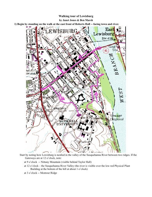
1) Begin by standing on the walk at the east front of Roberts Hall -- facing town and river.<br />
Start by noting how <strong>Lewisburg</strong> is nestled in the valley of the Susquehanna River between two ridges. If the<br />
Gateways are at 12 o’clock, note:<br />
at 9 o’clock -- Nittany Mountain (visible behind Taylor Hall)<br />
at 12 o’clock – the Susquehanna River Valley (the river is visible over the low red Physical Plant<br />
Building at the bottom of the hill at about 1 o’clock)<br />
at 3 o’clock -- Montour Ridge
Now note the details of the scene before you:<br />
at 6 o’clock – Roberts Hall (the second oldest college building, dedicated in 1850) which was<br />
originally called Main Building and then “Old Main”. It contained recitation rooms, a chapel, a<br />
library, meeting rooms, and a Commencement Hall on the third floor, which was the site of early<br />
commencements. The wings contained study rooms and dormitories. You are standing on the east<br />
side which was once the principle façade of the structure but which is now mostly forgotten as the<br />
campus has turned its focus away from town and toward Highway 15.<br />
at 9 o’clock -- Taylor Hall (the oldest building on campus, opened in 1849) to which the newly<br />
founded college moved from the basement of the Baptist meeting house in <strong>Lewisburg</strong><br />
at 10 o’clock – <strong>Bucknell</strong> Hall (dedicated in 1868) and used as the campus chapel for decades; it is<br />
now a recital hall and home of the Stadler Poetry Center.<br />
at 11 o’clock – <strong>University</strong> Ave., once the principle access to campus when the college was more<br />
closely tied to the town for both its students and its identity; it is now still the ceremonial entrance<br />
to campus from the town side -- What is the principal formal entrance to campus now? and what<br />
does this say about the orientation of the college? what is the principal informal entrance to the<br />
college and why is it so heavily traveled?<br />
at 12 o’clock – the Gateways stand over the site of the original football field<br />
2) Walk down three short sections of staircase and turn left down the walkway to the bottom the hill.<br />
Stop at the flagpole between the gateposts and face down <strong>University</strong> Ave.<br />
You are now standing at the original entrance to campus looking down the wide ceremonial avenue which<br />
led to “The Hill” as it was known. Note that <strong>University</strong> Ave. cuts diagonally toward campus defying<br />
the rectilinear plan of most town streets (take this occasion to have a good look at your copy of the<br />
town plan, the layout should be very familiar to you) and self-consciously connecting the town to the<br />
periphery and to the isolated academics who had taken residence on the hill to the south of town.<br />
To your left on the far corner is the President’s House. It was built in 1855 by Rev. Justin R. Loomis,<br />
Professor of Natural Sciences and President who bought a one-acre lot from the Trustees for $ 400.00<br />
and built the Gothic Revival house. In 1879, the <strong>University</strong> bought the house and enlarged it for<br />
David J. Hill, who was President from 1879 to 1888. It has been the home of <strong>Bucknell</strong> presidents ever<br />
since.<br />
To your right on the far corner is the Lowry House bought by the university and renovated in 1985 to<br />
house Psychological Services. It was the home of the famous hymn writer (“Shall We Gather at the<br />
River”) Rev. Robert Lowry, Class of 1854, Professor of Rhetoric, and pastor of the First Baptist<br />
Church from 1869 to 1875. Read the Historical Marker.<br />
3) Walk down <strong>University</strong> Avenue, noting as you pass:<br />
Cooley Hall (the 1890’s Italianate mansion on the right at the corner of <strong>University</strong> Ave. and Malcolm St.)<br />
and surrounding buildings in which the machines of <strong>University</strong> Relations (e.g. alumni relations, fund<br />
raising) hum away at a distance from the academic programs.<br />
#63 <strong>University</strong> Avenue (on left) current home (Victorian/Queen Ann/Eclectic style) of Judge McClure and<br />
noted as the location (in the carriage house) of a stop on the Underground Railroad. Read the<br />
Historical Marker as you pass.<br />
Bull Run (running under <strong>University</strong> Avenue) a quaint, but deadly creek which flows into the Susquehanna<br />
River just out of sight to the right. Many of you are familiar with its dangers from the September flood<br />
of 1999.<br />
The Civil War monument at the end of <strong>University</strong> Avenue on the right which commemorates the town’s<br />
terrible losses typical of those suffered by small towns all over during the Civil War.<br />
4) Turn right down Mill St., the little one-way connector road just before the Civil War Monument, cross<br />
Third St., then Brown St., to the Historical Marker just to the left of the Derr House (the large white<br />
house set back from Brown St.).
The Derr House was originally the home of Ludwig Derr, founder of <strong>Lewisburg</strong> in 1785. He purchased a<br />
large parcel of land on the banks of the Susquehanna where he built a profitable grist mill, surveyed<br />
the parcel for settlement using the grid plan with which we are familiar, and died as early plans for the<br />
settlement were going forward.<br />
If you look to the right (east) you see Mill St. headed toward the river and, tracing it back the way you have<br />
just come, you are actually seeing the path of the old mill race for the grist mill which took its water<br />
from a weir on Bull Run.<br />
5) Walk up Brown St. noting as you pass:<br />
The typical college town combination of student, faculty, and other local resident housing.<br />
6) Turn right and walk down St. George, noting as you pass:<br />
The “flood proof” condominium group recently built along lower St. George which appear to be normal<br />
townhouses until….(to be continued below)<br />
The flood gauge painted on the street sign at the corner with Front St. (for reference, the 1973 flood was 34<br />
ft., the January flood of 1996 was 25 ft).<br />
The town boat launch at the end of the St. George St.<br />
7) Walk back up St. George and turn right up the alley, noting:<br />
…the back of the townhouses which are built so that the entire first floor is garage and non-living space in<br />
case of (almost certain) flooding.<br />
The arrangement of the typical <strong>Lewisburg</strong> residential lot with a house fronting on the street (usually not set<br />
back to any degree), a long narrow yard, and a garage on the alley.<br />
All blocks in the area of the original town survey were split by an alley running north/south (parallel to the<br />
river) except the blocks fronting on Market St. in which the alley runs east/west.<br />
8) Turn left up St. Catherine, turn right on Second St. and walk up to the Union County Courthouse.<br />
Stand on the sidewalk in front of the Cronrath Funeral Home and note the neo-Classical east façade of the<br />
courthouse in the Ionic order, rendered in wood. What “feeling” was the architect trying to induce in<br />
the observer with the use of this style?<br />
9) Turn right down St. Louis and walk toward the river.<br />
Look to the left and the right at the alley to see again the typical arrangement of alleys running north/south<br />
behind the houses.<br />
10) Near the corner of St. Louis and Front St. note:<br />
To the right, the Tasker Bliss House (just down Front St. a half block) – see the Historical Marker for<br />
details of another sidelight to <strong>Lewisburg</strong> history.<br />
To the left, signs of the “gentrification” (i.e. reconfiguring historic, traditional, and often somewhat rundown<br />
houses and neighborhoods to suit the need of the new “gentry”) of the <strong>Lewisburg</strong> housing<br />
market. Well-off doctors from the Geisinger Medical Center in Danville or other professionals<br />
working outside of <strong>Lewisburg</strong> have chosen the town as a residence for its atmosphere and poured<br />
money into the nicer homes in the town (note the custom-made orange shutters at 31 S. Front St.). In<br />
front of these houses, and in various other locations around town you can still see the stone used to<br />
help in mounting horses. See more on the gentrification of <strong>Lewisburg</strong> below.<br />
11) Continue down toward the river … at the corner of St. Louis and S. Water St. note:<br />
In the river, the remnants of the slackwater dam just south (right .. downstream) of the Water St. corner,<br />
extending all the way across the river and visible only in low water. This dam pooled the water so that<br />
canal boats could cross to <strong>Lewisburg</strong> from the Pennsylvania Canal which ran up the east side of the<br />
river. Canal boats were the first exportable product of the town and that industry was the antecedent<br />
of Pennsylvania House Furniture, <strong>Lewisburg</strong>’s most noted industry. (Where are they getting the wood<br />
over time and how were they transporting it?)
12) Walk up S. Water St., noting:<br />
The houses at #s 37 & 27 S. Water St. These are two of the earliest houses in <strong>Lewisburg</strong> (dated to 1786 and<br />
1789 respectively). #37 was the first store and school. Note the orientation of these houses toward the<br />
river. (Look at the houses across the street at #24 & 26 [built in the 1850s] and #18 & 20 [built in the<br />
1860s] -- which way do these houses face? what does this say about the importance of the river and<br />
the outlook of the town 60 years later? Why didn’t people love the river then? where did their sewage<br />
go? )<br />
The east/ west alley on the left runs parallel to Market St. rather than at a right angle to it.<br />
The flood gauge on the back of the garage nearest to S. Water St. (remember 34 ft. was the height of the<br />
1973 flood – now look at the level of the houses on the river side of the road nearby. Hmmm.)<br />
13) Turn right and walk out on the bridge (Market St. / PA Route 45) until you are standing over the<br />
river’s edge.<br />
Note that the houses along the river have no alley or garages, in fact, their yards (and first floors,<br />
sometimes) lie within the flood plain of the river. The river rose over the lower yards of these houses<br />
in January 1996.<br />
Depending on the time of day you are here, you should be able to notice the high level of traffic (especially<br />
truck traffic) across this bridge and through downtown <strong>Lewisburg</strong>. The passage of Rt. 45, an important<br />
east/west corridor, through town is both a blessing and a curse -- good for business, bad for sleeping.<br />
14) Walk back off the bridge and down Market St. away from the river, noting:<br />
Soldiers Memorial Park upstream of the bridge, with round twin foundations of water towers by the bridge,<br />
and the low, red former factory building of Pennsylvania House behind the railroad grade just beyond<br />
the park. Established at the site of a canal boat works, this was the “Chair Factory” for decades, and<br />
has become an antique mall in the last few years … it’s the pre industrial, industrial, and postindustrial<br />
story of the town in one building.<br />
The Ionic architecture of the neo-classical Presbyterian church building on the right between Water and<br />
Front Sts.<br />
The large houses of the wealthy lining this main artery leading to the commercial district of town.<br />
The town is giving lessons in gentrification. Beyond Front St. look for the earring store, the glass gold<br />
jewelry and leather wallet store, the Celtic everything store, the fly fishing and mountain bike store,<br />
the “collectibles” store, and, in recent memory, the cigar store, the gourmet coffee and new age<br />
personal growth bookstore, the pricey camera equipment store, the Italian ices store (oops -- now a<br />
chiropractor’s office), and the ammunition store. Interspersed with these are the fewer longtime local<br />
stores -- two framing galleries, a stationery store, a bargain priced movie theater, and the downtown<br />
grocery -- but lost in recent memory is the local butcher, the old time drugstore, and (several<br />
generations of bank buy-outs ago) all the local banks (e.g. <strong>Lewisburg</strong> National, <strong>Lewisburg</strong> Trust).<br />
15) At the corner of Market and Second St., note:<br />
The next two blocks of Market St. were the original market area of town – what does Market St. do here<br />
that reveals this?<br />
The <strong>Lewisburg</strong> Hotel built in 1831 just as the canal and the railroad brought big business to town.<br />
16) At the corner of Market and Third St., note:<br />
Here the two main avenues of <strong>Lewisburg</strong> intersect. Market and Third Streets are wider than the other<br />
streets of town and were planned as the principal east/west and north/south corridors. For residents of<br />
<strong>Lewisburg</strong>, this is the main intersection of town – interestingly, when I have asked students (several<br />
hundred over 10 years) to identify the main intersection of town they have rarely listed this<br />
intersection, seeing Rt. 15 & Market St, or 7th & Market as the main intersection – what does this<br />
reveal about the geographical picture that students have formed of the town?
Note the Doric architecture (and pronounced entasis of the columns) on the Sovereign Bank, the Doric<br />
porches on the Post Office, and the Ionic architecture of the Mellon Bank.<br />
Detour south one block to the intersection of Third and St. Louis where there are churches on three of four<br />
corners – what does this say about the spatial arrangement of <strong>Lewisburg</strong> as compared to an ancient<br />
city?<br />
On the way back to Market St. note the pier of the old Opera House (1869) at the entrance to the town<br />
parking lot on the left (west) side of the street. This parking lot preserves the footprint of this<br />
important communal entertainment structure which burned early in the 20 th century.<br />
Note the ugly structure which now houses the CVS — this was built to replace an imposing structure which<br />
burned (see illustration of Market St. at top.)<br />
Continue west on Market St.<br />
17) Cross Market St. and walk up the north (CVS) side of Market. Stop at the corner of Market and<br />
Fourth Sts. and note:<br />
Market St. does again what it did at Market and Second, marking the end of the central market area.<br />
The Ionic architecture of the M&T bank.<br />
The orange and blue tiled, Art-Deco “Campus Theatre” where you can still see first runs in a spacious old<br />
time theater at small town prices and walk home at 11pm feeling reasonably safe. It’s recently under<br />
new management and showing more interesting films while retaining its small town feel.<br />
At the corner of Market and 5 th Sts, Subway is situated in a magnificent example of late 19 th C commercial<br />
architecture – the façade of this building is cast iron.<br />
18) Walk to the railroad tracks, turn right and walk down the tracks to Roller Mill (the large red<br />
building on the left almost to St. Mary).<br />
This area represents the second major phase of industrial development at <strong>Lewisburg</strong>, the railroad based<br />
industrial center (as opposed to the early mills and factory by the river which represent the first phase<br />
of industrial development — river based industrial center). You will find the newer, road based<br />
industrial centers along Rt. 192 exemplified by the huge PlayWorld headquarters building, or JPM<br />
Industries and the old International Paper factory along Rt. 15.<br />
Note:<br />
• on the left the warehouse structures ranging along the tracks toward Rt. 15.<br />
• the large mill at the junction of the two rail lines — one line runs north/south along the river; the<br />
other runs east/west crossing the river, running along the line of present St. John and then west to<br />
Mifflinburg and beyond. Note the two sidings curving to join the n/s line; one is represented by<br />
multiple concrete piers in the low area to the south of the mill<br />
• Bechtels, the <strong>Lewisburg</strong> dairy, has its plant and warehouses farther up the tracks, near Rt. 15.<br />
19) Walk back and turn right on Market St.; stop just past the Lilac Moon Restaurant, and note:<br />
Hufnagle Park, the large open area across the street. This once was a block of structures similar to the<br />
others, but many structures here by the creek (note how Market St. slopes down to Bull Run) were<br />
razed after the flood in 1972 and a park was established in the flood plain. It was named in honor of<br />
the former <strong>Lewisburg</strong> chief of police who died here trying to rescue someone from rising water in<br />
1972.<br />
In the middle distance – at St. Louis and Fifth Sts. – is the Borough Office building in the old railroad<br />
terminal. Generations of <strong>Bucknell</strong> students arrived in <strong>Lewisburg</strong> at this spot.<br />
In the distance, the large (some would say too large) PlayWorld castle funded through donations and set up<br />
in the fall of 2000 by local volunteers including <strong>Bucknell</strong> students. It replaces a smaller wooden<br />
“climber” which was considered outdated, unsafe, and decrepit. PlayWorld is an international supplier<br />
of playground equipment which recently set up a large headquarters building and factory in<br />
<strong>Lewisburg</strong>.
The bandstand in the park, site of numerous touching small town communal events — the Christmas tree<br />
lighting, the 4 th of July band music concert, music in the park on summer evenings, peace rallies, etc.<br />
It is also popular with local skateboarders.<br />
20) Walk on to the bridge over Bull Run and note<br />
The rip-rapping of Bull Run to stabilize the stream bank against flood erosion.<br />
The bridge small footbridge to the right constructed by a <strong>Bucknell</strong> civil engineering class.<br />
21) Continue up Market St. noting the signs that you are nearing the college:<br />
Multiple pizza places and bars.<br />
For rent signs in ill-kept properties (there are no “condemned” signs in sight at the moment) advertising<br />
vacancies two years from now.<br />
22) Walk up to the intersection of Market (Rt. 45) and Rt. 15:<br />
This is the high traffic intersection in town. Looking at the properties on the 4 corners of this intersection<br />
and the degree of access to them, why would you say that several of the businesses here have gone out<br />
of business several times. What businesses work best here? Who are they aimed at — local residents or<br />
passers through?<br />
Note how Rt. 45 changes orientation after it crosses Rt. 15 heading west into the Linntown area. Look at<br />
your town map and note how this affects the planning of the grid as settlement extended toward the<br />
west.<br />
23) Walk back to 8th St., turn right and walk to the cemetery, noting:<br />
The quiet, residential street just a block off of raucous, busy 7 th St.<br />
The large town cemetery which, like most town cemeteries of the 1820s AD or 600s BC, was built at the<br />
far periphery, or just outside, of the town. Most ancient cemeteries which were engulfed like this<br />
vanished.<br />
24) Walk back to campus through the cemetery on the small road which continues the line of 8 th St.:<br />
Read some of the tomb stones — what is the earliest date you can find on this route? Remember that town<br />
was founded in 1785, so some of these folks were first generation residents.